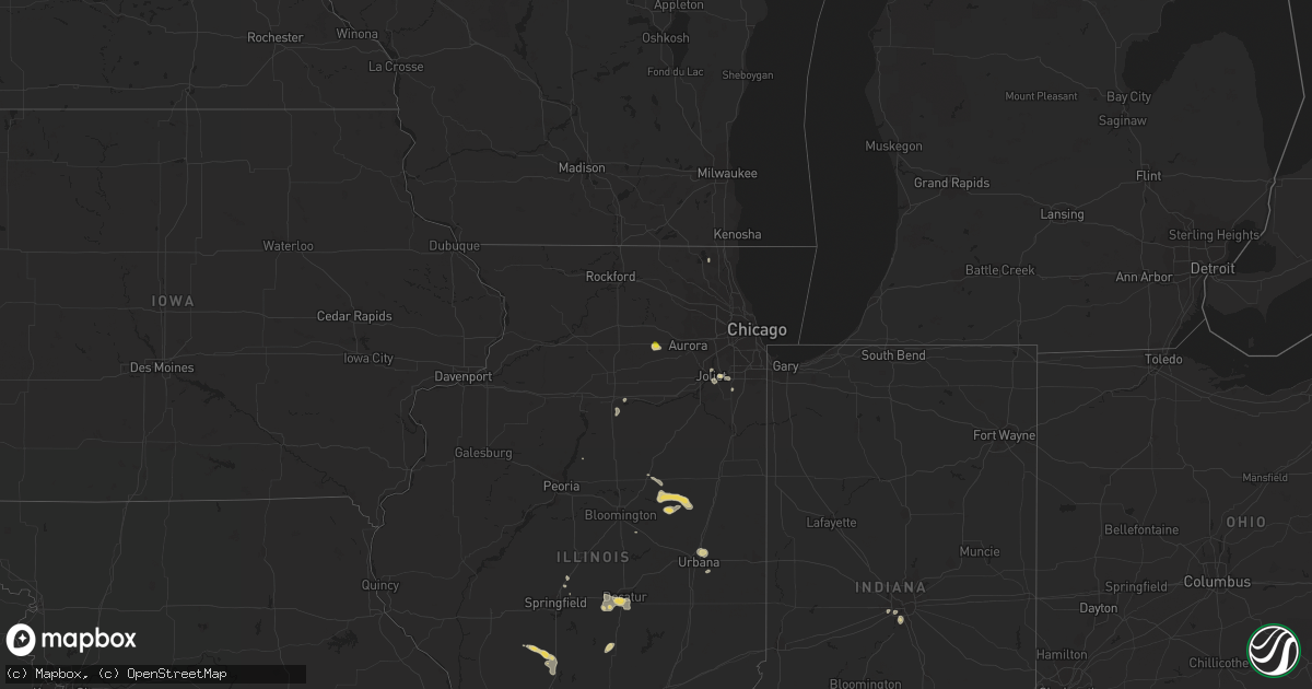
Hail Map on August 28, 2017
Get this storm
August 28 map
$229
one time, instant access
Download today. No call, no setup
Keep the $229
Bought the map and want the full workflow? Apply the entire $229 to a subscription within 7 days. None of it is wasted.
Every map, not just this one
This buys you this map. Subscription and you get every map we run, in the markets you choose from a few cities to whole states to nationwide. Plus real-time alerts the moment a storm fires.
Contact data
Name, contact info, occupancy, even credit band for addresses in the footprint. You go from where it hit to who to call.
Become the source they trust
Unlimited branding weather history reports on demand. You already have the documented answer ready for the property owner, and you are the one who showed up with it.
Property data and RoofTrace estimates
Pull up any address you have got, its value and the exact code rules for that jurisdiction, straight from One Click Code. Then RoofTrace estimates the squares, pitch, and roof value, priced the way you price.
States Impacted by Hail Map on August 28, 2017
Storm reports
New Mexico
| Date | Description |
|---|---|
| 08/28/20176:30 PM CDT | A local report indicates 65 MPH wind near CHAMIZAL |
Texas
| Date | Description |
|---|---|
| 08/28/20179:49 AM CDT | Sheriffs dept reports tree down. |
Louisiana
| Date | Description |
|---|---|
| 08/28/201712:11 PM CDT | Sheriffs dept reports trees down on catahoula hwy near st martinville. |
Indiana
| Date | Description |
|---|---|
| 08/28/20175:30 AM CDT | A tree and a large limb down. |
Cities Impacted by Hail Map on August 28, 2017
- Tijeras, NM
- Polvadera, NM
- Las Vegas, NM
- Mora, NM
- Cleveland, NM
- Urbana, IL
- Decatur, IL
- Macon, IL
- Modesto, IL
- Waggoner, IL
- Litchfield, IL
- Girard, IL
- Raymond, IL
- Carlinville, IL
- Nilwood, IL
- Palmyra, IL
- Big Rock, IL
- Hinckley, IL
- Greenwood, IN
- Indianapolis, IN
- Trementina, NM
- Colfax, IL
- Cropsey, IL
- Sibley, IL
- Blue Mound, IL
- Ferdinand, IN
- Dale, IN
- Santa Claus, IN
- Lamar, IN
- Los Lunas, NM
- New Lenox, IL
- Champaign, IL
- Pecos, NM
- Joliet, IL
- Springer, NM
- Sidney, IL
- Littlefield, TX
- Garita, NM
- Ingleside, IL
- Round Lake, IL
- Lake Villa, IL
- Mokena, IL
- Raton, NM
- Lemitar, NM
- Niantic, IL
- Mt Zion, IL
- Boody, IL
- Mount Auburn, IL
- Anchor, IL
- Saybrook, IL
- Gibson City, IL
- Williamsville, IL
- Elwood, IL
- Pana, IL
- Frankfort, IL
- Monee, IL
- Utica, IL
- Ottawa, IL
- Seymour, IN
- Amherst, TX
- Tererro, NM
- Assumption, IL
- Oglesby, IL
- Tonica, IL
- Estancia, NM
- Albuquerque, NM
- Washburn, IL
- Rociada, NM
- Elkhart, IL
- Strawn, IL
- Melvin, IL
- Fairbury, IL
- Glorieta, NM
- Ute Park, NM
- Edgewood, NM
- Chenoa, IL
- Lockport, IL
- Crest Hill, IL
- Holman, NM
- Wagon Mound, NM
- Valmora, NM
- Silver City, NM