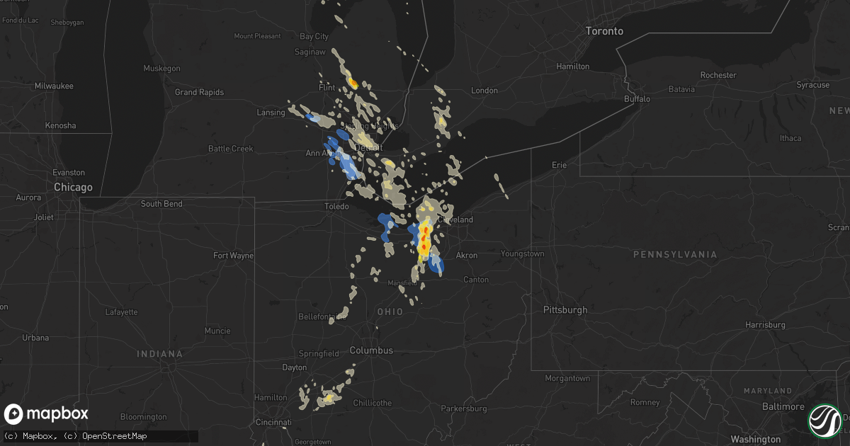
Hail Map on August 23, 2023
Get this storm
August 23 map
$229
one time, instant access
Download today. No call, no setup
Keep the $229
Bought the map and want the full workflow? Apply the entire $229 to a subscription within 7 days. None of it is wasted.
Every map, not just this one
This buys you this map. Subscription and you get every map we run, in the markets you choose from a few cities to whole states to nationwide. Plus real-time alerts the moment a storm fires.
Contact data
Name, contact info, occupancy, even credit band for addresses in the footprint. You go from where it hit to who to call.
Become the source they trust
Unlimited branding weather history reports on demand. You already have the documented answer ready for the property owner, and you are the one who showed up with it.
Property data and RoofTrace estimates
Pull up any address you have got, its value and the exact code rules for that jurisdiction, straight from One Click Code. Then RoofTrace estimates the squares, pitch, and roof value, priced the way you price.
Storm reports
Michigan
| Date | Description |
|---|---|
| 08/23/20238:28 AM CDT | Picture sent on social media of hail near ping-pong ball and quarter size. |
| 08/23/20232:53 AM CDT | Mdot reported tree down at telegraph rd and erie rd. |
| 08/23/20232:12 AM CDT | Image of downed power lines on haggerty and w maple rd. |
| 08/23/20231:48 AM CDT | Mdot reported tree down at telegraph rd and stein rd. |
| 08/23/20231:20 AM CDT | Huron charter township police department reported multiple trees and power lines down throughout the city. |
| 08/23/20231:12 AM CDT | Dispatch reported trees down across the whole county. |
| 08/23/202312:45 AM CDT | South lyon fire reported trees down near whipple st and hagadorn st. |
| 08/22/202310:50 PM CDT | Pictures sent of large tree limbs downed at 16th and pine in wyandotte. |
North Dakota
| Date | Description |
|---|---|
| 08/22/20238:31 PM CDT | Heavy rain with wind gusts 40 to 45. |
Florida
| Date | Description |
|---|---|
| 08/22/20237:14 PM CDT | A tree was blown down near the intersection of lisenby ave and airport rd. |
Colorado
| Date | Description |
|---|---|
| 08/22/20237:00 PM CDT | Power lines down. Row of trees knocked over. Estimated 70 mph winds. |
Ohio
| Date | Description |
|---|---|
| 08/23/20231:38 PM CDT | Report from mping: 1-inch tree limbs broken; shingles blown off. |
| 08/23/20231:38 PM CDT | Steeple blown off church and several barn roofs partially blown off. |
| 08/23/20231:25 PM CDT | Report from mping: 1-inch tree limbs broken; shingles blown off. |
| 08/23/20236:16 AM CDT | Awos station ksgh springfield-beckley airport. |
| 08/23/20235:39 AM CDT | Trees and wires down. House lost part of a roof with debris on roadway. |
| 08/23/20234:50 AM CDT | Several large tree branches down and at least 1 large tree uprooted. |
| 08/23/20234:35 AM CDT | Large tree down on u.s. 50. |
| 08/23/20234:32 AM CDT | Tree down on route 134. |
| 08/23/20234:28 AM CDT | Partial sheet metal roof removed from outbuilding. Time estimated by radar. |
| 08/23/20233:47 AM CDT | Several trees downed in washington courthouse and jeffersonville areas. Time estimated by radar. |
| 08/23/20232:47 AM CDT | Large tree downed along riverside road. Time estimated by radar. |
| 08/23/20231:48 AM CDT | Photo on twitter of a few large tree limbs down on main street in bluffton. |
| 08/23/20231:19 AM CDT | Tree blown down over road in patterson. Time estimated from radar. |
| 08/23/20231:00 AM CDT | Power pole downed. |
| 08/23/202312:55 AM CDT | Power pole downed. |
| 08/22/202311:51 PM CDT | Tree and wires down in martin township. |
| 08/22/202311:30 PM CDT | Tree downed onto a porch. |
| 08/22/202311:15 PM CDT | A local report indicates 60 MPH wind near Vickery |
| 08/22/202310:27 PM CDT | Large tree down across road. |
| 08/22/202310:00 PM CDT | A couple trees were blown down on south bass island. |
| 08/22/20239:56 PM CDT | Ottawa county ema reporting multiple large trees blown down near catawba and port clinton. |
| 08/22/20239:56 PM CDT | Port clinton asos measured a 60 mph wind gust. |
| 08/22/20239:53 PM CDT | A local report indicates 1.25 inch wind near 2 S Ashland |
| 08/22/20239:49 PM CDT | *** 2 inj *** erie county em reporting a large tree into a house with injuries. |
| 08/22/20239:41 PM CDT | Multiple large tree limbs blown down in sandusky. |
| 08/22/20239:35 PM CDT | Awos station kpcw port clinton. |
| 08/22/20239:20 PM CDT | Us42 and tr810 trailer park garage blown off and into mobile home. Fd called for persons trapped inside house. Time estimated via radar. |
| 08/22/20238:41 PM CDT | Golf ball size hail reported in wellington... Oh. |
| 08/22/20238:24 PM CDT | Tree down and transformer on fire. |
| 08/22/20238:18 PM CDT | Corrects previous flash flood report from 2 n lorain. Numerous trees down across the city of lorain. |
| 08/22/20238:00 PM CDT | A local report indicates 1.00 inch wind near 1 NE Lorain |
| 08/22/20237:54 PM CDT | Two minutes of hail ranging from quarter to golf ball sized in elyria twp. |
| 08/22/20237:48 PM CDT | Picture from social media of quarter size hail. |
| 08/22/20237:48 PM CDT | Telephone or power pole blown down in lorian near orchard hill and cooper foster. |
| 08/22/20237:46 PM CDT | Multiple reports received on social media of at least quarter size hail between lorain and sheffield lake. |
Utah
| Date | Description |
|---|---|
| 08/22/20238:10 PM CDT | Mesonet station utdol dolomite. |
Indiana
| Date | Description |
|---|---|
| 08/23/20236:45 AM CDT | Large tree branches down in marion. |
| 08/23/20235:40 AM CDT | Abc21 reports a downed large tree limb resulted in a power outage to about 800 customers. |
Cities Impacted by Hail Map on August 23, 2023
- Lapeer, MI
- Attica, MI
- Harsens Island, MI
- Vassar, MI
- Ortonville, MI
- Hubbard Lake, MI
- Curran, MI
- Mikado, MI
- Oscoda, MI
- Clarkston, MI
- Washington, MI
- Romeo, MI
- Leonard, MI
- Sebewaing, MI
- Prescott, MI
- Whittemore, MI
- Rochester, MI
- Tawas City, MI
- Au Gres, MI
- Millington, MI
- New Baltimore, MI
- Macomb, MI
- Hamtramck, MI
- Detroit, MI
- Hazel Park, MI
- Ferndale, MI
- Highland Park, MI
- Warren, MI
- Pleasant Ridge, MI
- Madison Heights, MI
- Royal Oak, MI
- Oakland, MI
- Armada, MI
- Ray, MI
- Oxford, MI
- Dryden, MI
- Metamora, MI
- Utica, MI
- Allenton, MI
- Almont, MI
- Hale, MI
- Otisville, MI
- Otter Lake, MI
- Mayville, MI
- Fostoria, MI
- Reese, MI
- Columbiaville, MI
- North Branch, MI
- Turner, MI
- Omer, MI
- Twining, MI
- Imlay City, MI
- Auburn Hills, MI
- Pontiac, MI
- Berkley, MI
- Grosse Pointe, MI
- Franklin, MI
- Oak Park, MI
- Southfield, MI
- Bloomfield Hills, MI
- Huntington Woods, MI
- Clawson, MI
- Birmingham, MI
- Troy, MI
- Spencer, OH
- Lodi, OH
- Medina, OH
- Burbank, OH
- Westfield Center, OH
- Creston, OH
- Homerville, OH
- Seville, OH
- West Salem, OH
- Wooster, OH
- Smithville, OH
- Sterling, OH
- Austinburg, OH
- Rock Creek, OH
- Geneva, OH
- Jefferson, OH
- Crosby, ND
- Noonan, ND
- Columbus, ND
- Port Sanilac, MI
- Carsonville, MI
- Peach Springs, AZ
- Lignite, ND
- Portal, ND
- Sheffield Lake, OH
- Avon, OH
- Lorain, OH
- Avon Lake, OH
- Vermilion, OH
- Wakeman, OH
- Amherst, OH
- Elyria, OH
- Oberlin, OH
- Lagrange, OH
- Grafton, OH
- Kipton, OH
- Wellington, OH
- Minot, ND
- Norwich, ND
- Sawyer, ND
- Velva, ND
- Sullivan, OH
- New London, OH
- Nova, OH
- Voltaire, ND
- Lakeside Marblehead, OH
- Sandusky, OH
- Huron, OH
- Port Clinton, OH
- Castalia, OH
- Bellevue, OH
- Monroeville, OH
- Kenmare, ND
- Donnybrook, ND
- Butte, ND
- Berthold, ND
- Ashland, OH
- Grantsville, UT
- Litchfield, OH
- Powers Lake, ND
- Lynn Haven, FL
- Panama City, FL
- Palermo, ND
- Lakewood, OH
- Burlington, ND
- Flaxton, ND
- Collins, OH
- Greenwich, OH
- Shiloh, OH
- Stanley, ND
- Plaza, ND
- Polk, OH
- Jeromesville, OH
- Valley City, OH
- Columbia Station, OH
- Clinton Township, MI
- Des Lacs, ND
- Lake Orion, MI
- Goodrich, MI
- North Ridgeville, OH
- South Lyon, MI
- Northville, MI
- Plymouth, MI
- Howell, MI
- Romulus, MI
- Belleville, MI
- Wayne, MI
- New Boston, MI
- Fenton, MI
- Carleton, MI
- Flat Rock, MI
- Taylor, MI
- South Rockwood, MI
- Newport, MI
- Rockwood, MI
- Canton, MI
- Ypsilanti, MI
- Monroe, MI
- Trenton, MI
- Fowlerville, MI
- Ann Arbor, MI
- Walled Lake, MI
- Wixom, MI
- Novi, MI
- Farmington, MI
- Livonia, MI
- Whitmore Lake, MI
- Milan, MI
- Willis, MI
- Holly, MI
- Highland, MI
- Davisburg, MI
- Ruso, ND
- Tiffin, OH
- New Riegel, OH
- Davison, MI
- Richwood, OH
- La Rue, OH
- Byron, MI
- Morrice, MI
- Bancroft, MI
- Perry, MI
- Laingsburg, MI
- Sterling Heights, MI
- Fraser, MI
- Galena, OH
- Morral, OH
- Harpster, OH
- Redford, MI
- Dearborn Heights, MI
- Dearborn, MI
- Westland, MI
- Upper Sandusky, OH
- Sycamore, OH
- Carey, OH
- North Fairfield, OH
- Norwalk, OH
- Willard, OH
- Danville, OH
- Perrysville, OH
- Loudonville, OH
- Marion, OH
- Williamston, MI
- Webberville, MI
- Butler, OH
- Bellville, OH
- Allen Park, MI
- River Rouge, MI
- Melvindale, MI
- Wyandotte, MI
- Lincoln Park, MI
- Ecorse, MI
- Mount Clemens, MI
- Brighton, MI
- Milford, MI
- Clyde, OH
- Fremont, OH
- Green Springs, OH
- Clio, MI
- Riverview, MI
- Southgate, MI
- Howard, OH
- Mount Vernon, OH
- Center Line, MI
- West Bloomfield, MI
- New Washington, OH
- Bucyrus, OH
- Bloomville, OH
- Harrison Township, MI
- Saint Clair Shores, MI
- New Bloomington, OH
- Hartland, MI
- Linden, MI
- Mansfield, OH
- Mcclusky, ND
- Raymond, OH
- West Mansfield, OH
- Marysville, OH
- Mount Sterling, OH
- Sabina, OH
- Leesburg, OH
- Wilmington, OH
- New Vienna, OH
- Waterford, MI
- Commerce Township, MI
- White Lake, MI
- Washington Court House, OH
- East Liberty, OH
- West Liberty, OH
- Zanesfield, OH
- Lynchburg, OH
- Blanchester, OH
- Midland, OH
- McCutchenville, OH
- New Holland, OH
- Waynesville, OH
- Clarksville, OH
- Hillsboro, OH
- Greenfield, OH
- Martinsville, OH
- Westlake, OH
- North Olmsted, OH
- Foster, KY
- Falmouth, KY
- Strongsville, OH
- Bloomingburg, OH
- Brooksville, KY
- Flushing, MI
- Flint, MI
- Goshen, OH
- Morrow, OH
- Oregonia, OH
- Pleasant Plain, OH
- Lebanon, OH
- Bay Village, OH
- Rocky River, OH
- Cleveland, OH
- Melbourne, KY
- Orient, OH
- Cincinnati, OH
- Xenia, OH
- Berry, KY
- Verona, KY
- Dry Ridge, KY