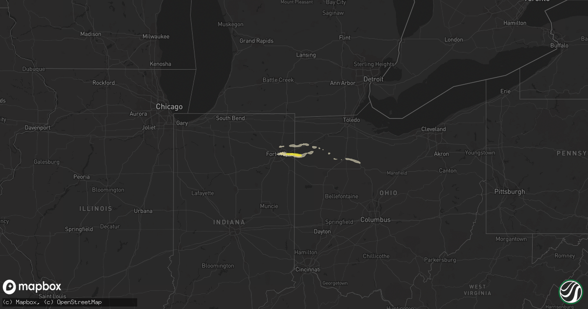
Hail Map on August 23, 2015
Get this storm
August 23 map
$229
one time, instant access
Download today. No call, no setup
Keep the $229
Bought the map and want the full workflow? Apply the entire $229 to a subscription within 7 days. None of it is wasted.
Every map, not just this one
This buys you this map. Subscription and you get every map we run, in the markets you choose from a few cities to whole states to nationwide. Plus real-time alerts the moment a storm fires.
Contact data
Name, contact info, occupancy, even credit band for addresses in the footprint. You go from where it hit to who to call.
Become the source they trust
Unlimited branding weather history reports on demand. You already have the documented answer ready for the property owner, and you are the one who showed up with it.
Property data and RoofTrace estimates
Pull up any address you have got, its value and the exact code rules for that jurisdiction, straight from One Click Code. Then RoofTrace estimates the squares, pitch, and roof value, priced the way you price.
States Impacted by Hail Map on August 23, 2015
Storm reports
Arizona
| Date | Description |
|---|---|
| 08/23/20155:30 PM CDT | Yavapai county em reported 41 structures with minor dmg...6 structures with major dmg...power poles and trees snapped...2300 without power |
Ohio
| Date | Description |
|---|---|
| 08/23/20156:25 PM CDT | Gas station attendant reported quarter sized hail during storm. |
| 08/23/20154:43 PM CDT | Report of trees down on homes. Time estimated from radar. |
| 08/23/20154:35 PM CDT | Several trees downed. Antenna broken. Metal roofing material removed from home on rt 111. One wall collapsed and portion of roof removed from a pole barn along krouse r |
| 08/23/20154:34 PM CDT | Two large trees down onto power lines. Time estimated from radar. |
| 08/23/20154:32 PM CDT | A local report indicates 1.00 inch wind near 2 WSW PAYNE |
| 08/23/20154:06 PM CDT | Report of large limbs down on top of two homes. Time estimated from radar. |
Georgia
| Date | Description |
|---|---|
| 08/23/20154:40 PM CDT | Tree down on top of garage in the 1800 block of bowen street. Time of event estimated by radar. |
| 08/23/20154:21 PM CDT | Tree down in the laurel island subdivision. Time estimated by radar. |
| 08/23/20153:35 PM CDT | Tree and power line down on swamp road. Time estimated by radar. |
| 08/23/20152:45 PM CDT | Several reports of trees and power lines down in and around the waycross area. Some locations included north mcdonald road and also frank cowart lane. A small tree fell |
| 08/23/20152:30 PM CDT | Numerous...on the order of several dozen...reports of trees and power lines down across lanier county. One tree was blown onto a power line...and both fell on a house. |
| 08/23/20152:28 PM CDT | Trees blown down blocking highway 135 north. |
| 08/23/20152:23 PM CDT | Trees down blocking giddens lane. |
| 08/23/20152:04 PM CDT | Two trees down in the clyattville area. |
| 08/23/20151:30 PM CDT | Sylvania fire dept reports multiple trees down on private property in the sylvan heights neighborhood. Time estimated from radar |
| 08/23/20159:30 AM CDT | 911 call center received reports of numerous trees and powerlines down across fort valley. Some locations include west church st...knoxville st...north jones st...and w |
Indiana
| Date | Description |
|---|---|
| 08/23/20154:05 PM CDT | 2-3 ft diameter limbs down and partial barn roof blown off. Time estimated from radar. |
Florida
| Date | Description |
|---|---|
| 08/23/20155:15 PM CDT | Central dispatch reported a tree down on a home off of underhill drive in the arlington area. |
| 08/23/20155:06 PM CDT | Central dispatch reported a tree down on a power line and on fire on lyle lane near the ortega area. |
| 08/23/20154:57 PM CDT | Central dispatch reported a tree down on power lines at palmdale street and lake park drive. |
| 08/23/20154:52 PM CDT | Tree and power line down on beech street in fernandina beach. Time estimated by radar. |
| 08/23/20154:50 PM CDT | Central dispatch reported a tree down on power lines on pitts road. |
| 08/23/20154:35 PM CDT | Tree down on brandies ave. Time estimated by radar. |
| 08/23/20154:16 PM CDT | Multiple trees reported down in the glen saint mary area. Time estimated by radar. |
| 08/23/20153:57 PM CDT | Tree down on county road 250. Time estimated by radar. |
| 08/22/20157:00 PM CDT | Several trees down in palm coast. Estimated wind speed 50 mph. |
Texas
| Date | Description |
|---|---|
| 08/23/20155:50 PM CDT | 50 to 60 mph wind gusts estimated in westover. |
| 08/23/201512:40 PM CDT | Large tree fell and damaged fence. Dime size hail and about 1 inch of rain. |
Cities Impacted by Hail Map on August 23, 2015
- Ringgold, TX
- Bellevue, TX
- Olney, TX
- Sweetwater, TX
- Roby, TX
- Odessa, TX
- Ty Ty, GA
- Sumner, GA
- Andrews, TX
- Seminole, TX
- Payson, AZ
- Throckmorton, TX
- Nashville, AR
- Roscoe, TX
- Sells, AZ
- Pecos, TX
- Grabill, IN
- Antwerp, OH
- Harlan, IN
- Cecil, OH
- Omega, GA
- Norman Park, GA
- Lenox, GA
- Rotan, TX
- High Springs, FL
- Alachua, FL
- Haviland, OH
- Payne, OH
- Avoca, TX
- Cove, AR
- Stanton, TX
- Windthorst, TX
- Scotland, TX
- Henrietta, TX
- Seymour, TX
- Stamford, TX
- Hermleigh, TX
- Midland, TX
- Garden City, TX
- Big Lake, TX
- Holliday, TX
- Newcastle, TX
- Woodburn, IN
- Melrose, OH
- Fort Wayne, IN
- New Haven, IN
- Monroeville, IN
- Paulding, OH
- Oakwood, OH
- Tonto Basin, AZ
- Lueders, TX
- Fitzgerald, GA
- Ocilla, GA
- Fort Stockton, TX
- Palatka, FL
- Sopchoppy, FL
- Crawfordville, FL
- Ottawa, OH
- Leipsic, OH
- Dawson, GA
- Bainbridge, GA
- Loving, NM
- Eustis, FL
- Mount Dora, FL
- Trenton, FL
- Lakeland, FL
- Loxahatchee, FL
- Abbeville, GA
- Quitman, GA
- Carey, OH
- Richmond, TX
- Lamesa, TX
- Tarzan, TX
- Rimrock, AZ
- Goldsmith, TX
- Defiance, OH
- Pine, AZ
- Pandora, OH
- Mount Cory, OH
- Albany, GA
- Marshallville, GA
- Fort Valley, GA
- Vanlue, OH
- Mount Blanchard, OH
- Findlay, OH
- Arlington, OH
- Elko, GA
- Kermit, TX
- Pineview, GA
- Rochelle, GA
- Snyder, TX
- Sulphur Springs, TX
- Fargo, GA
- Umatilla, FL
- Wichita Falls, TX
- Hawkinsville, GA
- Vandervoort, AR
- Plant City, FL
- Polk City, FL
- Lithia, FL
- Carlsbad, NM
- Anson, TX
- Nowata, OK
- Carrabelle, FL
- Continental, OH
- New Bavaria, OH
- Globe, AZ
- Miami, AZ
- Rawson, OH
- Sallisaw, OK
- Alapaha, GA
- Panacea, FL
- Loving, TX
- Adel, GA