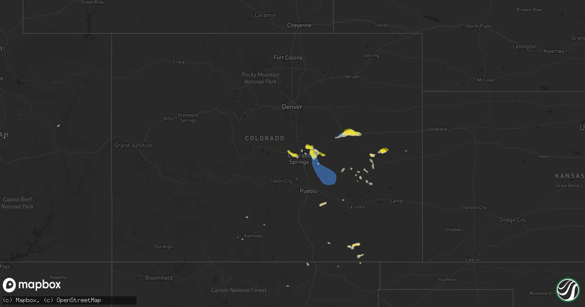
Hail Map on August 20, 2024
Get this storm
August 20 map
$229
one time, instant access
Download today. No call, no setup
Keep the $229
Bought the map and want the full workflow? Apply the entire $229 to a subscription within 7 days. None of it is wasted.
Every map, not just this one
This buys you this map. Subscription and you get every map we run, in the markets you choose from a few cities to whole states to nationwide. Plus real-time alerts the moment a storm fires.
Contact data
Name, contact info, occupancy, even credit band for addresses in the footprint. You go from where it hit to who to call.
Become the source they trust
Unlimited branding weather history reports on demand. You already have the documented answer ready for the property owner, and you are the one who showed up with it.
Property data and RoofTrace estimates
Pull up any address you have got, its value and the exact code rules for that jurisdiction, straight from One Click Code. Then RoofTrace estimates the squares, pitch, and roof value, priced the way you price.
States Impacted by Hail Map on August 20, 2024
Storm reports
Colorado
| Date | Description |
|---|---|
| 08/20/20246:42 PM CDT | Report from mping: quarter |
| 08/19/20249:15 PM CDT | Asos station klic limon. |
| 08/19/20247:31 PM CDT | Report from mping: quarter |
| 08/19/20247:30 PM CDT | A local report indicates 1.00 inch wind near 4 ESE Falcon |
| 08/19/20247:29 PM CDT | A local report indicates 1.00 inch wind near 3 E Falcon |
Montana
| Date | Description |
|---|---|
| 08/20/20246:09 PM CDT | Personal weather station. |
| 08/20/20245:45 PM CDT | Delayed report. Public report of wheat fields damaged by quarter size hail. Time/location estimated. |
| 08/20/20245:30 PM CDT | Mesonet station mtbzh bozeman pass |
| 08/20/20245:14 PM CDT | Ambient weather sensor in bozeman. |
| 08/20/20244:10 PM CDT | Trained spotter reports hail up to quarter sized. |
| 08/20/20243:30 PM CDT | Corrects time on previous hail report from 2 e sheridan. Trained spotter reports hail between one and two inches in diameter. Hail shattered/splattered on impact. |
| 08/20/20243:20 PM CDT | Trained spotter reports half dollar sized hail while driving through sheridan. Time estimated using radar. |
| 08/20/20243:20 PM CDT | Trained spotter reports hail between one and two inches in diameter. Hail shattered/splattered on impact. |
| 08/19/202411:15 PM CDT | Mesonet station mtlnd 7.9 nw lindsay |
| 08/19/202411:00 PM CDT | Asos station kggw glasgow airport |
South Carolina
| Date | Description |
|---|---|
| 08/20/20244:47 PM CDT | Golf bail sized hail at connecticut avenue and highway 261. Wind snapping small tree branches. |
| 08/20/20243:49 PM CDT | Railroad crossing gates damaged by winds near 9 mile curve on georgetown highway. |
Cities Impacted by Hail Map on August 20, 2024
- Grouse Creek, UT
- Dubois, ID
- Jamestown, SC
- Ute Park, NM
- Twin Bridges, MT
- Sheridan, MT
- Georgetown, SC
- Norris, MT
- Alder, MT
- Virginia City, MT
- Hemingway, SC
- Longs, SC
- Fairburn, SD
- McAllister, MT
- Model, CO
- Little River, SC
- Rio Rico, AZ
- Kim, CO
- Benson, AZ
- Calabash, NC
- Tuba City, AZ
- Longwood, NC
- Tabor City, NC
- Ash, NC
- Bozeman, MT
- Livingston, MT
- Gallatin Gateway, MT
- Mosca, CO
- Branson, CO
- Ocean Isle Beach, NC
- Sunset Beach, NC
- Rapelje, MT
- Nakina, NC
- Conway, SC
- La Jara, CO
- Ryegate, MT
- Heber, AZ
- Chester, MT
- Bolton, NC
- Colorado Springs, CO
- Woodland Park, CO
- Elbert, CO
- Tucson, AZ
- Peyton, CO
- Green Mountain Falls, CO
- Cascade, CO
- Pawleys Island, SC
- Calhan, CO
- Myrtle Beach, SC
- Leland, NC
- Delco, NC
- Manitou Springs, CO
- Patagonia, AZ
- Green River, UT
- Nogales, AZ
- Billings, MT
- Karval, CO
- Hardin, MT
- Kit Carson, CO
- Manhattan, MT
- Haswell, CO
- Yoder, CO
- Boone, CO
- Limon, CO
- Olney Springs, CO
- Matheson, CO
- Cohagen, MT
- Manzanola, CO
- Rocky Ford, CO
- Genoa, CO
- Forsyth, MT
- Hugo, CO
- Fort Peck, MT
- Rudyard, MT
- Loring, MT
- Brockway, MT
- Glasgow, MT
- Nashua, MT
- Lindsay, MT
- Terry, MT
- Circle, MT
- Bloomfield, MT
- Glendive, MT
- Beaumont, TX
- Hamshire, TX
- Winnie, TX
- Buffalo, SD