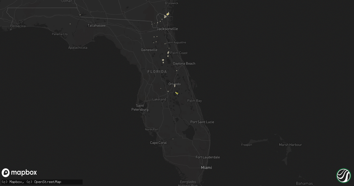
Hail Map on August 20, 2015
Get this storm
August 20 map
$229
one time, instant access
Download today. No call, no setup
Keep the $229
Bought the map and want the full workflow? Apply the entire $229 to a subscription within 7 days. None of it is wasted.
Every map, not just this one
This buys you this map. Subscription and you get every map we run, in the markets you choose from a few cities to whole states to nationwide. Plus real-time alerts the moment a storm fires.
Contact data
Name, contact info, occupancy, even credit band for addresses in the footprint. You go from where it hit to who to call.
Become the source they trust
Unlimited branding weather history reports on demand. You already have the documented answer ready for the property owner, and you are the one who showed up with it.
Property data and RoofTrace estimates
Pull up any address you have got, its value and the exact code rules for that jurisdiction, straight from One Click Code. Then RoofTrace estimates the squares, pitch, and roof value, priced the way you price.
States Impacted by Hail Map on August 20, 2015
Storm reports
Virginia
| Date | Description |
|---|---|
| 08/20/20155:48 PM CDT | Tree down on sinclair mill road just off of dumfries road. |
Georgia
| Date | Description |
|---|---|
| 08/20/20154:50 PM CDT | Multiple large tree branches and wires down in the sugarmill subdivision. Time estimated by radar. |
| 08/20/20154:45 PM CDT | Multiple large tree branches reported down in the laurel island and the lakes subdivisions. Time estimated by radar. |
Florida
| Date | Description |
|---|---|
| 08/20/20156:23 PM CDT | Wilson boulevard is closed in both directions at old middleburg road due to power lines down. |
| 08/20/20154:20 PM CDT | Broadcast media relayed a report of a large tree down at jammes road and turknett road between blanding and i-295. Possible vehicle involved with injuries. |
| 08/20/20154:15 PM CDT | Wilson boulevard is closed in both directions at old middleburg road due to power lines down. |
| 08/20/20154:12 PM CDT | Large tree down near the intersection of north hwy 314a and east hwy 40. Time estimated by radar. |
South Carolina
| Date | Description |
|---|---|
| 08/20/20151:50 PM CDT | Large tree down on house on taft street near the intersection of old jericho rd. Time estimated from radar |
New Jersey
| Date | Description |
|---|---|
| 08/19/201511:30 PM CDT | 40 section of a tree and telephone pole knocked over. |
Texas
| Date | Description |
|---|---|
| 08/19/201511:55 PM CDT | A local report indicates 64 MPH wind near 4 N PRESIDIO |
Pennsylvania
| Date | Description |
|---|---|
| 08/20/20155:05 PM CDT | Possible tornado damage intersection of rte 304 and red ridge road. |
| 08/20/20154:45 PM CDT | Limb down on road in millerstown. |
| 08/20/201512:46 PM CDT | Wires down in conewago twp. In two locations |
Arizona
| Date | Description |
|---|---|
| 08/20/20155:15 PM CDT | Power poles down... Mud and debris across road causing road closures. |
| 08/20/20153:08 PM CDT | A local report indicates 60 MPH wind near 2 S FORT HUACHUCA |
Cities Impacted by Hail Map on August 20, 2015
- Medina, TX
- Tarpley, TX
- Sonoita, AZ
- Elgin, AZ
- Elfrida, AZ
- Fort Davis, TX
- Bisbee, AZ
- Marana, AZ
- Jourdanton, TX
- Townsend, GA
- Saint Marys, GA
- Kingsland, GA
- Willcox, AZ
- Loving, NM
- Alpine, TX
- Marathon, TX
- Patagonia, AZ
- Tucson, AZ
- Amado, AZ
- Rio Rico, AZ
- Nogales, AZ
- Poteet, TX
- Bigfoot, TX
- Demopolis, AL
- Sierra Vista, AZ
- Rixeyville, VA
- Boston, VA
- Castleton, VA
- Stonewall, MS
- Enterprise, MS
- Hilliard, FL
- Yulee, FL
- Gainesville, VA
- Warrenton, VA
- Broad Run, VA
- Nokesville, VA
- Sells, AZ
- Atkinson, NE
- Brandon, MS
- Green Cove Springs, FL
- Santa Fe, TX
- Gallion, AL
- Linden, AL
- Tumacacori, AZ
- Tubac, AZ
- The Plains, VA
- Haymarket, VA
- Carrizozo, NM
- Goliad, TX
- Rio Grande City, TX
- Hattiesburg, MS
- Seadrift, TX
- Green Valley, AZ
- Lake City, FL
- Utopia, TX
- Citronelle, AL
- Woodbine, GA
- Labelle, FL
- Metter, GA
- Lucedale, MS
- Callahan, FL
- Kissimmee, FL
- San Antonio, TX
- Von Ormy, TX
- Hereford, AZ
- Kenedy, TX
- Lawtey, FL
- Riceboro, GA
- Lake, MS
- Fort McCoy, FL
- Amelia, NE
- Thomaston, AL
- Somerset, TX
- Hampton, FL
- Amissville, VA
- Charlotte, TX
- Deland, FL
- Orange City, FL
- Mount Hermon, LA
- Franklinton, LA
- Saint Cloud, FL
- East Palatka, FL
- Bainbridge, GA
- Safford, AL
- Marion Junction, AL
- Lisman, AL
- Satsuma, FL
- San Mateo, FL
- Pomona Park, FL
- Crescent City, FL
- Fort Huachuca, AZ
- Orlando, FL
- Altha, FL
- Meridian, MS
- Arivaca, AZ
- Marshall, VA