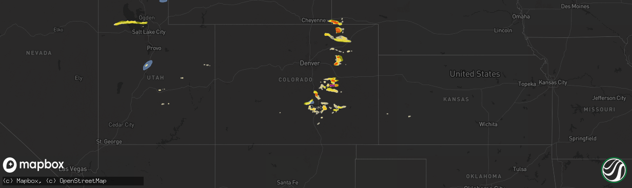
Hail Map on August 19, 2024
The weather event on August 19, 2024 includes Hail, Wind, and Tornado maps. 13 states and 266 cities were impacted and suffered possible damage. The total estimated number of properties impacted is 79,117.
Want more than just the map?
Turn this storm into a full workflow.
- Owner + property data so you know who to knock
- OnDemand branded weather history reports to win the "did we even have hail?" argument
- RoofTrace estimate so reps stop guessing numbers at the door
Bought this map? Upgrade within 7 days and we'll credit the $230. (10-15 min setup call)
Hail
Wind
Tornado
79,117
Estimated number of impacted properties by a 1.00" hail or larger11,115
Estimated number of impacted properties by a 1.75" hail or larger127
Estimated number of impacted properties by a 2.50" hail or largerStates Impacted by Hail Map on August 19, 2024
Storm reports
Colorado
| Date | Description |
|---|---|
| 08/19/20246:43 PM CDT | Report from mping. |
| 08/19/20246:38 PM CDT | Report from mping: quarter |
| 08/19/20246:36 PM CDT | A local report indicates 1.00 inch wind near 7 ENE Antelope Springs |
| 08/19/20246:33 PM CDT | Report relayed via nws bou. |
| 08/19/20246:31 PM CDT | A local report indicates 1.50 inch wind near 6 NE Kutch |
| 08/19/20246:12 PM CDT | Report from mping: quarter |
| 08/19/20246:12 PM CDT | Report from mping: quarter |
| 08/19/20245:58 PM CDT | Mesonet station co132 050e290 penrose. |
| 08/19/20245:30 PM CDT | Via social media with picture. |
| 08/19/20245:18 PM CDT | Report from mping: ping pong ball |
| 08/19/20244:03 PM CDT | Large tree limb... 6 inches in diameter... Snapped. Marble hail and torrential rain. |
| 08/19/20244:00 PM CDT | A local report indicates 60 MPH wind near 8 S Shamrock |
| 08/19/20243:55 PM CDT | Location approximate. |
| 08/19/20243:21 PM CDT | Report from mping: ping pong ball |
| 08/19/20243:04 PM CDT | Landspout. Estimated to be 4-5 miles south/southeast of prospect rd and cr 152 in eastern adams county. |
| 08/18/20249:15 PM CDT | A local report indicates 1.50 inch wind near Avondale |
| 08/18/20248:51 PM CDT | Tree limbs down. |
| 08/18/20248:40 PM CDT | Relayed via broadcast media. |
| 08/18/20247:12 PM CDT | Report from mping. |
Wyoming
| Date | Description |
|---|---|
| 08/19/20246:50 PM CDT | *** 1 inj *** person suffered elbow contusion from flying debris at campground and had to receive medical attention. Numerous reports of broken windows... Building dama |
| 08/19/20246:50 PM CDT | Reports of trees down and broken windows. |
| 08/19/20246:50 PM CDT | Hail is over a foot deep. |
| 08/19/20246:50 PM CDT | Multiple powerline poles are down in the hullett and oshoto area. |
| 08/19/20246:50 PM CDT | Numerous reports of broken windows... Building damage... Extensive camper/vehicle damage... And extensive tree damage throughout the devils tower area. |
| 08/19/20246:50 PM CDT | Wind driven baseball size hail broke out windows on vehicles... Buildings... And campers. |
| 08/19/20245:10 PM CDT | Report from mping: 3-inch diameter tree limbs broken; power poles broken. |
| 08/19/20245:04 PM CDT | Corrects previous tstm wnd dmg report from 7 sw pine bluffs. Report from mping: 3-inch diameter tree limbs broken; power poles broken. |
| 08/18/20249:10 PM CDT | Large accumulations of hail... Varying in size from 0.5 to 1.00 inch. Pictures showed accumulations of 1 to 2 inches of hail on the ground. |
| 08/18/20247:30 PM CDT | Hail is covering the ground. |
Arizona
| Date | Description |
|---|---|
| 08/19/20246:36 PM CDT | Video and comment on social media showing heavy rain and hail with an estimated size of 1 inch diameter. |
| 08/19/20243:54 PM CDT | Asos station kols nogales international airport. |
Utah
| Date | Description |
|---|---|
| 08/19/20246:50 PM CDT | Measured at the nephi west pacificorp site. |
| 08/19/202412:45 AM CDT | Mesonet station otru1 otter creek. |
| 08/18/202411:45 PM CDT | A tree fell through the roof of a home... Rendering it unlivable. Time estimated by radar and nearby observations. |
| 08/18/20249:45 PM CDT | Lakeside mountain mesonet site lmr. |
Montana
| Date | Description |
|---|---|
| 08/19/20246:48 PM CDT | Public weather station. |
| 08/19/20245:58 PM CDT | A local report indicates 1.00 inch wind near 5 NNE Huson |
| 08/19/20244:30 PM CDT | A local report indicates 1.75 inch wind near 7 E Polaris |
| 08/18/202410:10 PM CDT | A local report indicates 62 MPH wind near 4 W Havre |
| 08/18/202410:00 PM CDT | Delayed report. Wunderground sensor kmtchest53. |
| 08/18/20249:45 PM CDT | Mesonet station mtswt sweetgrass |
| 08/18/20249:45 PM CDT | Mesonet station gw3530 rudyard eleven south. |
| 08/18/20249:25 PM CDT | Mesonet station gw3862 loma eighteen nw. |
| 08/18/20249:25 PM CDT | Mesonet station jpkm8 judith peak raws. Time estimated via radar given raws reports once per hour. |
| 08/18/20249:15 PM CDT | Delayed report. Wunderground sensor kmtchest53. |
| 08/18/20249:15 PM CDT | Mesonet station gw3478 tctiber. |
| 08/18/20249:06 PM CDT | Spotter traveling northbound on highway 87 noted two snapped power poles near mile marker 31. Confirmed power outages in the area. |
| 08/18/20249:00 PM CDT | Mesonet station mtden denton |
| 08/18/20249:00 PM CDT | A local report indicates 65 MPH wind near Lewistown |
| 08/18/20248:55 PM CDT | Mesonet station gw1987 ethridge three se. |
| 08/18/20248:43 PM CDT | A local report indicates 1.00 inch wind near 1 W Columbia Falls |
| 08/18/20248:25 PM CDT | A local report indicates 59 MPH wind near 4 SSW Valier |
| 08/18/20248:20 PM CDT | A local report indicates 63 MPH wind near 7 E Brady |
| 08/18/20248:11 PM CDT | Corrects previous non-tstm wnd gst report from 5 wsw great falls. Asos station kgtf great falls airport. |
| 08/18/20248:00 PM CDT | A local report indicates 1.50 inch wind near 3 ESE Bigfork |
| 08/18/20247:40 PM CDT | Hail fell for about 10 minutes. |
| 08/18/20247:06 PM CDT | Two rounds of hail in and around the bison range. Gusts to 53 mph with the first round of hail. |
| 08/18/20247:00 PM CDT | Corrects previous non-tstm wnd gst report from 6 ese east helena. Mesonet station mtspk spokane creek us-287 mp 55.7. |
Nebraska
| Date | Description |
|---|---|
| 08/19/20245:15 PM CDT | Radar estimated time of trained storm spotter report of golf ball sized hail occurring. |
| 08/19/20245:00 PM CDT | Awos station k1ew 6 se pine bluffs. |
North Carolina
| Date | Description |
|---|---|
| 08/19/20245:34 PM CDT | One tree down on pineville-matthews rd near fire station 24. |
| 08/19/20245:00 PM CDT | Tree down at 1931 south point rd. |
| 08/19/20244:52 PM CDT | Large tree limbs down on 226 king george lane. |
| 08/19/20243:39 PM CDT | Fallen trees caused power outage south of nc-62 near bowman dairy rd. |
| 08/19/20243:39 PM CDT | Multiple reports of quarter sized hail near the julian... Nc area. |
| 08/19/20243:28 PM CDT | Numerous trees down in and just north of stony point. Tree fell on a building on alexander rd and trapped animals inside. |
| 08/19/20243:23 PM CDT | Trees and lines down at cheatham ford rd and lawzyday farm dr. Time estimated. |
| 08/19/20243:20 PM CDT | Trees down on stikeleather rd just on iredell side of county line. Time estimated. |
| 08/19/20243:15 PM CDT | Trees down on cool springs rd. |
| 08/19/20242:53 PM CDT | Tree and power lines fell on a vehicle on dyson rd and trapped occupant. Time estimated. |
South Dakota
| Date | Description |
|---|---|
| 08/19/202412:06 AM CDT | A local report indicates 60 MPH wind near 3 NW Wasta |
| 08/18/202411:50 PM CDT | A local report indicates 1.00 inch wind near Box Elder |
| 08/18/202411:25 PM CDT | A local report indicates 60 MPH wind near 14 SSE Hereford |
| 08/18/202411:00 PM CDT | A local report indicates 1.75 inch wind near 9 NE Tilford |
| 08/18/202411:00 PM CDT | Winds estimated to be at least 80 mph |
| 08/18/202411:00 PM CDT | Severe barn damage... Numerous trees down. Winds estimated to be at least 80 mph. |
| 08/18/202410:35 PM CDT | A local report indicates 60 MPH wind near 12 WSW Hereford |
| 08/18/202410:15 PM CDT | A local report indicates 1.00 inch wind near 3 W Galena |
| 08/18/20249:38 PM CDT | A local report indicates 1.25 inch wind near Tilford |
| 08/18/20249:01 PM CDT | A local report indicates 2.00 inch wind near Brownsville |
| 08/18/20249:00 PM CDT | A local report indicates 1.75 inch wind near 2 SW Galena |
| 08/18/20248:45 PM CDT | A local report indicates 1.00 inch wind near Deadwood |
| 08/18/20248:45 PM CDT | A local report indicates 2.00 inch wind near 3 ESE Cheyenne Crossing |
| 08/18/20248:45 PM CDT | A local report indicates 1.75 inch wind near Deadwood |
| 08/18/20248:32 PM CDT | A local report indicates 1.00 inch wind near Dwtn Spearfish |
Virginia
| Date | Description |
|---|---|
| 08/19/20245:15 PM CDT | Personal weather station gusted to 63 mph. |
| 08/19/20244:40 PM CDT | Tree down on route 17 near yorktown high school. |
| 08/19/20244:35 PM CDT | Tree down near the american revolution museum in yorktown. |
| 08/19/20244:24 PM CDT | Tree down on woodyard rd. Time estmated from radar. |
| 08/19/20244:03 PM CDT | 2 trees down on prince george drive. |
| 08/19/20243:42 PM CDT | Tree down on sturgeon point rd near the glebe lane. |
| 08/19/20243:42 PM CDT | Large tree limbs down. |
| 08/19/20243:39 PM CDT | Tree down along alpine road. |
| 08/19/20243:39 PM CDT | Multiple trees and power lines down along route 5. Time estimated from radar. |
| 08/19/20243:29 PM CDT | Trees down. |
| 08/19/20243:29 PM CDT | Trees and power lines down in the road. |
| 08/19/20243:29 PM CDT | Tree down near intersection of barnetts rd and church lane. |
| 08/19/20243:26 PM CDT | Tree down across old union rd near perks lane. |
| 08/19/20243:20 PM CDT | Tree and powerlines down along poplar springs road. |
| 08/19/20242:58 PM CDT | Tree down on power line at intersection of beach rd and otterdale rd. Time estimated from radar. |
| 08/19/20242:50 PM CDT | Tree down on power lines near river rd. Time estimated from radar. |
| 08/19/20242:50 PM CDT | Tree down across road at intersection of nailor way and newberg lane. Time estimated by radar. |
| 08/19/20242:50 PM CDT | A coop observer reported a large tree snapped and fallen over in ashland. The tree appeared to be rotten on the inside. |
| 08/19/20242:10 PM CDT | A tree has fallen across the road onto power lines. |
Cities Impacted by Hail Map on August 19, 2024
- Malta, MT
- Ingomar, MT
- Forsyth, MT
- Sand Springs, MT
- Cohagen, MT
- Ramah, CO
- Simla, CO
- Rosebud, MT
- Blanch, NC
- Harmony, NC
- Statesville, NC
- Fort Morgan, CO
- Roxboro, NC
- Semora, NC
- Leasburg, NC
- Agate, CO
- Woodrow, CO
- Whitsett, NC
- Calhan, CO
- Julian, NC
- Greensboro, NC
- Matheson, CO
- Havelock, NC
- Liberty, NC
- Helena, MT
- Sonoita, AZ
- Burgess, VA
- Reedville, VA
- Baskerville, VA
- South Hill, VA
- Limon, CO
- Douglas, AZ
- Ramseur, NC
- Rio Rico, AZ
- Deer Trail, CO
- Brodnax, VA
- La Crosse, VA
- Staley, NC
- Patagonia, AZ
- Pine Bluffs, WY
- Huachuca City, AZ
- Wise River, MT
- Divide, MT
- Bushnell, NE
- Hemingford, NE
- Darby, MT
- Decker, MT
- Sheridan, WY
- Conner, MT
- Savage, MT
- Sidney, MT
- Hanksville, UT
- Briggsdale, CO
- Elgin, AZ
- Manhattan, MT
- Kimball, NE
- Belvidere, NC
- Elizabeth City, NC
- New Raymer, CO
- Vail, AZ
- Weston, CT
- Fairfield, CT
- Westport, CT
- Easton, CT
- Elbert, CO
- Weston, WY
- Colorado Springs, CO
- Whitehall, MT
- Melfa, VA
- Painter, VA
- Onancock, VA
- Hacksneck, VA
- Belle Haven, VA
- Exmore, VA
- Accomac, VA
- Onley, VA
- Quinby, VA
- Padroni, CO
- Stoneham, CO
- Alberton, MT
- Frenchtown, MT
- Philipsburg, MT
- Florence, CO
- Penrose, CO
- Fountain, CO
- Rockvale, CO
- Coal Creek, CO
- Alliance, NE
- Peyton, CO
- Ferron, UT
- Whitney, NE
- Merino, CO
- Pueblo, CO
- Dillon, MT
- Boulder, MT
- Moorcroft, WY
- Devils Tower, WY
- Chadron, NE
- Mount Lemmon, AZ
- McLeod, MT
- Nye, MT
- Tucson, AZ
- Dix, NE
- Canon City, CO
- Hulett, WY
- Yoder, CO
- Tarboro, NC
- Nephi, UT
- Dixon, MT
- Charlo, MT
- Lucama, NC
- Clancy, MT
- Jefferson City, MT
- East Helena, MT
- Malta, ID
- Beulah, CO
- Rush, CO
- Sundance, WY
- Willcox, AZ
- Fremont, NC
- Wilson, NC
- Elk City, ID
- Snyder, CO
- Stanford, MT
- Alva, WY
- Geyser, MT
- Polson, MT
- Brockton, MT
- Hobson, MT
- Sterling, CO
- Hugo, CO
- Big Timber, MT
- Big Arm, MT
- Mona, UT
- Wiggins, CO
- Geraldine, MT
- Two Dot, MT
- Benson, AZ
- Beulah, WY
- Akron, CO
- Aladdin, WY
- Lolo, MT
- Plains, MT
- Ronan, MT
- Choteau, MT
- Karval, CO
- Bigfork, MT
- Lakeside, MT
- Williamston, NC
- Raynesford, MT
- Saint Ignatius, MT
- Dutton, MT
- Rockland, ID
- Spearfish, SD
- Olney Springs, CO
- Ravalli, MT
- Arlee, MT
- Rollins, MT
- Conrad, MT
- Shelby, MT
- Ledger, MT
- Cascade, MT
- Great Falls, MT
- Brady, MT
- Fairfield, NC
- Lead, SD
- Ordway, CO
- Chocowinity, NC
- Belt, MT
- Sand Coulee, MT
- Black Eagle, MT
- Fort Benton, MT
- Floweree, MT
- Highwood, MT
- Deadwood, SD
- Whitewood, SD
- Kalispell, MT
- Manzanola, CO
- Brush, CO
- Boone, CO
- Avondale, CO
- Blounts Creek, NC
- Coffee Creek, MT
- Somers, MT
- Columbia Falls, MT
- Wendover, UT
- Sugar City, CO
- Belle Fourche, SD
- Engelhard, NC
- Sturgis, SD
- Denton, MT
- Nemo, SD
- Cut Bank, MT
- Ethridge, MT
- Valier, MT
- Pendroy, MT
- Oilmont, MT
- Kevin, MT
- Galata, MT
- Bynum, MT
- Crowley, CO
- Carter, MT
- Kaycee, WY
- Burley, ID
- Midwest, WY
- Black Hawk, SD
- Piedmont, SD
- Arlington, CO
- Glenrock, WY
- Grouse Creek, UT
- Gillette, WY
- Nisland, SD
- Vale, SD
- Moccasin, MT
- Buffalo, MT
- Moore, MT
- Lewistown, MT
- Hilger, MT
- Winifred, MT
- Roy, MT
- Grass Range, MT
- Inverness, MT
- Rudyard, MT
- Big Sandy, MT
- Loma, MT
- Chester, MT
- Joplin, MT
- Hingham, MT
- Hungry Horse, MT
- Douglas, WY
- Heyburn, ID
- Whitefish, MT
- Fowler, CO
- Sweet Grass, MT
- Sunburst, MT
- Gildford, MT
- Whitlash, MT
- Havre, MT
- Box Elder, MT
- Kremlin, MT
- Chinook, MT
- Box Elder, SD
- New Underwood, SD
- Magna, UT
- Syracuse, UT
- Layton, UT
- Kaysville, UT
- Wasta, SD
- Owanka, SD
- Ellsworth Afb, SD
- Rapid City, SD
- Eagle Butte, SD
- Wall, SD
- Quinn, SD
- Philip, SD
- Polaris, MT
- Kadoka, SD
- Mobeetie, TX
- Laketown, UT
- Randolph, UT
- Kendall, KS
- Clarendon, TX
- Pampa, TX
- Garden City, KS
- Groom, TX
- Miami, TX