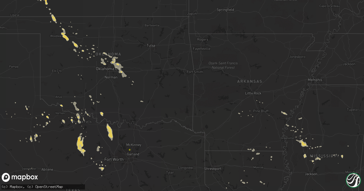
Hail Map on August 18, 2012
Get this storm
August 18 map
$229
one time, instant access
Download today. No call, no setup
Keep the $229
Bought the map and want the full workflow? Apply the entire $229 to a subscription within 7 days. None of it is wasted.
Every map, not just this one
This buys you this map. Subscription and you get every map we run, in the markets you choose from a few cities to whole states to nationwide. Plus real-time alerts the moment a storm fires.
Contact data
Name, contact info, occupancy, even credit band for addresses in the footprint. You go from where it hit to who to call.
Become the source they trust
Unlimited branding weather history reports on demand. You already have the documented answer ready for the property owner, and you are the one who showed up with it.
Property data and RoofTrace estimates
Pull up any address you have got, its value and the exact code rules for that jurisdiction, straight from One Click Code. Then RoofTrace estimates the squares, pitch, and roof value, priced the way you price.
States Impacted by Hail Map on August 18, 2012
Storm reports
New Mexico
| Date | Description |
|---|---|
| 08/17/20127:00 PM CDT | White sands missile range - phillips hill. |
Mississippi
| Date | Description |
|---|---|
| 08/18/20122:02 PM CDT | Minor shingle damage was reported and the tops of a few pine trees were blown off. |
| 08/18/20121:20 PM CDT | Trees downed near highway 433 and scotland road |
| 08/18/20121:20 PM CDT | Trees downed near highway 433 and scotland road |
Alabama
| Date | Description |
|---|---|
| 08/18/20126:07 PM CDT | About one dozen large hardwood trees uprooted or snapped in the city of linden. A few snapped trees were also visible on county road 44 5.5 miles northeast of linden. E |
Kansas
| Date | Description |
|---|---|
| 08/18/20128:55 AM CDT | A local report indicates 1.75 inch wind near 3 NE BLOOM |
| 08/18/20128:45 AM CDT | A local report indicates 1.00 inch wind near 4 NNW BLOOM |
| 08/18/20128:30 AM CDT | Dime size hail was also reported around this time and location. |
| 08/18/20128:30 AM CDT | A local report indicates 60 MPH wind near 5 W PROTECTION |
| 08/18/20128:30 AM CDT | A 24 foot stock trailer and a 500 bushel grain cart were blown over. |
| 08/18/20128:22 AM CDT | A local report indicates 60 MPH wind near 2 NW DODGE CITY |
| 08/18/20128:20 AM CDT | A local report indicates 60 MPH wind near DODGE CITY |
| 08/18/20128:15 AM CDT | A 4 inch diameter tree limb was downed on the north side of town. |
| 08/18/20128:02 AM CDT | Thunderstorms were reported to have destroyed a shed and broken a few windows in homes on the east side of town. A 2000 gallon empty fuel tank was blown into farm equip |
| 08/18/20127:44 AM CDT | A local report indicates 59 MPH wind near 5 NNW PIERCEVILLE |
Texas
| Date | Description |
|---|---|
| 08/18/20126:17 PM CDT | Trees down near the intersection of fm 1774 and fm 1488. |
| 08/18/20126:11 PM CDT | 3 to 5 inch diameter tree limbs down in hunsley hills |
| 08/18/20126:06 PM CDT | Law enforcement reported quarter sized hail in marfa. |
| 08/18/20125:56 PM CDT | Schoolnet site at midway alternative. |
| 08/18/20125:50 PM CDT | Power line down at hwy 380 and coy rd |
| 08/18/20124:37 PM CDT | Measured with handheld anemometer. |
| 08/18/20123:50 PM CDT | Medium sized limbs down and occasional roof damage in town. |
| 08/18/20123:10 PM CDT | Residential fences down on hideaway bay ct. |
| 08/17/201210:00 PM CDT | A local report indicates 59 MPH wind near 1 ENE MORTON |
| 08/17/20129:33 PM CDT | Large tree uprooted... Significant tree damage... Tin peeled off barn roof... Heavy rain |
| 08/17/20128:20 PM CDT | A local report indicates 62 MPH wind near 2 NE FRIONA |
| 08/17/20127:00 PM CDT | 6 inch diamter limbs down near moran along state highway 6 |
Cities Impacted by Hail Map on August 18, 2012
- Belzoni, MS
- Isola, MS
- Viking, MN
- Greenville, AL
- Uniontown, AL
- Buffalo, OK
- Mayer, AZ
- Devol, OK
- Loveland, OK
- Grandfield, OK
- Canyon, TX
- Graford, TX
- Loving, TX
- Olney, TX
- Newcastle, TX
- Windthorst, TX
- Bryson, TX
- Graham, TX
- Byers, TX
- Kenly, NC
- Crescent, OK
- Hennessey, OK
- Guthrie, OK
- Ensign, KS
- Minneola, KS
- Claude, TX
- Amarillo, TX
- Fairview, OK
- Chester, OK
- Seiling, OK
- Shaw, MS
- Superior, WI
- Shorter, AL
- Cecil, AL
- Pike Road, AL
- Rosanky, TX
- Luther, OK
- Wellston, OK
- Jones, OK
- Harrah, OK
- Camden, MS
- Arcadia, OK
- Edmond, OK
- Morton, TX
- Buckhorn, NM
- Mer Rouge, LA
- Oklahoma City, OK
- Yukon, OK
- Mansura, LA
- Marksville, LA
- Waelder, TX
- Harwood, TX
- Crowell, TX
- Weatherford, TX
- Cornville, AZ
- Sedona, AZ
- Rimrock, AZ
- Philadelphia, MS
- Farmerville, LA
- Ash Fork, AZ
- Dozier, AL
- Brantley, AL
- Piedmont, OK
- Hereford, TX
- Carrizozo, NM
- Canton, MS
- Waynoka, OK
- San Simon, AZ
- Fowler, KS
- Matador, TX
- Earth, TX
- Springlake, TX
- Amherst, TX
- Sudan, TX
- Cimarron, KS
- Jetmore, KS
- Dodge City, KS
- Elmer, OK
- Electra, TX
- Denham Springs, LA
- Iowa, LA
- Granbury, TX
- Smithville, TX
- Marion, LA
- Lake Worth Beach, FL
- Palm Beach, FL
- Tichnor, AR
- Bastrop, TX
- Giddings, TX
- Happy, TX
- Muenster, TX
- Saint Jo, TX
- Campbell, AL
- Silver City, NM
- Arenas Valley, NM
- Greenwood, MS
- Sidon, MS
- Iowa Park, TX
- Ruleville, MS
- Watonga, OK
- Itta Bena, MS
- Waurika, OK
- Ringling, OK
- Ryan, OK
- Bridgeport, TX
- Hammond, LA
- Girard, TX
- Seminole, OK
- Baton Rouge, LA
- Dimmitt, TX
- Banks, AL
- Poolville, TX
- Springtown, TX
- Fort Davis, TX
- Leola, AR
- Lawton, OK
- Duncan, OK
- Seymour, TX
- Lexington, MS
- Kingfisher, OK
- Shawnee, OK
- Comanche, OK
- Drew, MS
- Tutwiler, MS
- Konawa, OK
- Cleveland, MS
- Boyle, MS
- Indiahoma, OK
- Florien, LA
- Durant, MS
- Rosston, TX
- Era, TX
- Forestburg, TX
- Decatur, TX
- Prattville, AL
- Autaugaville, AL
- Citronelle, AL
- Aline, OK
- Old Glory, TX
- Lipan, TX
- Wichita Falls, TX
- Holliday, TX
- Mooreland, OK
- Mcloud, OK
- Payson, AZ
- Forest Home, AL
- Winslow, AZ
- Robeline, LA
- Provencal, LA
- Mule Creek, NM
- San Augustine, TX
- Whatley, AL
- Ford, KS
- South Range, WI
- Tecumseh, OK
- Meridian, OK
- Meeker, OK
- Choctaw, OK
- Ruston, LA
- Pickens, MS
- Sunflower, MS
- Carthage, MS
- Maud, OK
- Quitman, MS
- Flagstaff, AZ
- Meridian, MS
- Burkburnett, TX
- Yazoo City, MS
- Winston, NM
- Grady, AR
- Jasper, TX
- Nocona, TX
- Calumet, OK
- Ragley, LA
- Fremont, NC
- Pikeville, NC
- Winnsboro, LA
- De Witt, AR
- Rison, AR
- Longdale, OK
- Demopolis, AL
- Sanger, TX
- San Antonio, TX
- Pleasanton, TX
- Ashland, KS
- Union, MS
- Inverness, MS
- Cameron, LA
- Georgetown, TX
- Ringwood, OK
- Singer, LA
- Gainestown, AL
- Frisco City, AL
- Paducah, TX
- Hayneville, AL
- Lowndesboro, AL
- Bell City, LA
- Glen Rose, TX
- Rush Springs, OK
- Marlow, OK
- Dodson, LA
- Dacoma, OK
- Randlett, OK
- Hamburg, AR
- Strong, AR
- Goldsboro, NC
- Monroeville, AL
- Peterman, AL
- Millsap, TX
- Carnegie, OK
- Longville, LA
- Livingston, AL
- Frederick, OK
- Bentonia, MS
- Cloudcroft, NM
- Childress, TX
- Cresson, TX
- Okeene, OK
- Coushatta, LA
- Cottonwood, AZ
- Beatrice, AL
- Red Level, AL
- Petrolia, TX
- Hanover, NM
- Sweetwater, TX
- Aspermont, TX
- Leroy, AL
- Port Arthur, TX
- Okarche, OK
- Cashion, OK
- Muleshoe, TX
- Safford, AL
- Mescalero, NM
- Oakwood, OK
- Gainesville, TX
- Castroville, TX
- Elgin, OK
- Bernice, LA
- Butler, AL
- Huttig, AR
- Canton, OK
- Tchula, MS
- Indianola, MS
- Cee Vee, TX
- Tucker, AR
- Henrietta, TX
- Temple, OK
- Von Ormy, TX
- Vaughan, MS
- Sweet Water, AL
- Starks, LA
- Merryville, LA
- Paige, TX
- Flatonia, TX
- Kendalia, TX
- Converse, TX
- Camp Verde, AZ
- Cliff, NM
- Sikes, LA
- Paradise, TX
- Enterprise, MS
- Columbia, LA
- Coalgate, OK
- Woodland, AL
- Franklin, GA
- Seguin, TX
- Holden, LA
- Albany, LA
- Moorhead, MS
- Bellamy, AL
- Mineral Wells, TX
- Hurley, NM
- Sheridan, AR
- England, AR
- Many, LA
- Rohwer, AR
- Beulah, MS
- Rosedale, MS
- Plano, TX