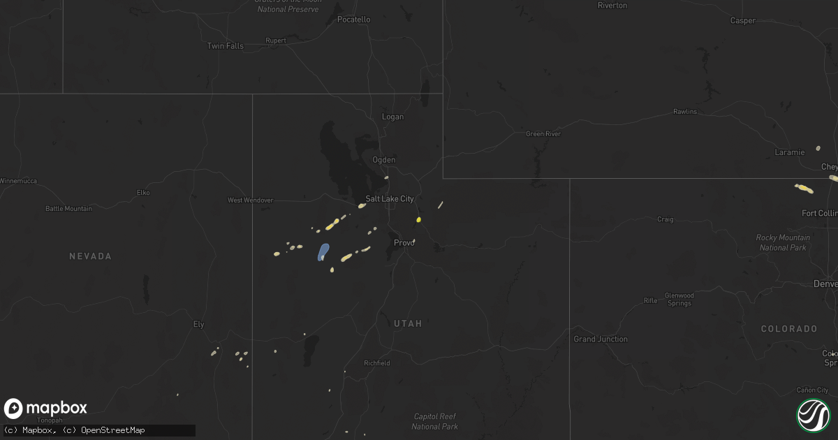
Hail Map on August 12, 2024
Get this storm
August 12 map
$229
one time, instant access
Download today. No call, no setup
Keep the $229
Bought the map and want the full workflow? Apply the entire $229 to a subscription within 7 days. None of it is wasted.
Every map, not just this one
This buys you this map. Subscription and you get every map we run, in the markets you choose from a few cities to whole states to nationwide. Plus real-time alerts the moment a storm fires.
Contact data
Name, contact info, occupancy, even credit band for addresses in the footprint. You go from where it hit to who to call.
Become the source they trust
Unlimited branding weather history reports on demand. You already have the documented answer ready for the property owner, and you are the one who showed up with it.
Property data and RoofTrace estimates
Pull up any address you have got, its value and the exact code rules for that jurisdiction, straight from One Click Code. Then RoofTrace estimates the squares, pitch, and roof value, priced the way you price.
States Impacted by Hail Map on August 12, 2024
Storm reports
Utah
| Date | Description |
|---|---|
| 08/12/20245:10 PM CDT | Mesonet station dpg05 white sage. |
| 08/12/20244:50 PM CDT | Mesonet station dpg23 lower cedar mtn. |
| 08/12/20244:14 PM CDT | A local report indicates 1.00 inch wind near Heber City |
| 08/12/20244:00 PM CDT | Mesonet station dpg18 causeway. |
| 08/12/20244:00 PM CDT | Power pole |
| 08/12/20242:50 PM CDT | Mesonet station dpg22 nw decon pad. |
| 08/12/20242:45 PM CDT | Mesonet station dpg05 white sage. |
| 08/12/20242:35 PM CDT | Mesonet station dpg11 tower grid. |
| 08/11/20247:40 PM CDT | Mesonet station pc347 alta aquaduct. |
Colorado
| Date | Description |
|---|---|
| 08/12/20246:30 PM CDT | A local report indicates 2.00 inch wind near 3 NE Pawnee Buttes |
| 08/12/20245:52 PM CDT | Corrects previous hail report from 11 n pawnee buttes. |
| 08/11/20249:06 PM CDT | Windows blown out in brush... Estimated due to high straight line winds. |
| 08/11/20248:27 PM CDT | Reports of apparent tornado damage. Powerlines and trees down. |
| 08/11/20247:51 PM CDT | A local report indicates 58 MPH wind near 9 SE Hugo |
| 08/11/20247:43 PM CDT | A local report indicates 68 MPH wind near 8 NNW Boyero |
| 08/11/20247:15 PM CDT | A local report indicates 1.50 inch wind near 1 NNW Olney Springs |
Wyoming
| Date | Description |
|---|---|
| 08/12/20244:56 PM CDT | Emergency manager reported 1 inch hail in pine bluffs. |
| 08/12/20244:53 PM CDT | Storm chaser reported 1.2 inch hail in pine bluffs. |
| 08/12/20244:48 PM CDT | Storm chaser reports 60mph winds in pine bluffs. |
| 08/12/20244:48 PM CDT | Storm chaser reports half dollar sized hail in pine bluffs. |
| 08/12/20244:38 PM CDT | Storm chaser reporting golf ball sized hail 6n of pine bluffs. |
| 08/12/20244:28 PM CDT | Storm chaser reports 1.8 inch hail via spotter network. |
| 08/12/20244:10 PM CDT | A local report indicates 1.00 inch wind near 9 SW Albin |
Oklahoma
| Date | Description |
|---|---|
| 08/11/20248:30 PM CDT | Report relayed to our office by the cimarron county emergency manager. Time was estimated based on radar data. |
Montana
| Date | Description |
|---|---|
| 08/12/20246:55 PM CDT | Awos station k00u 2 wnw hardin likely microburst. |
| 08/12/20246:55 PM CDT | Large tree limbs down. |
| 08/12/20246:53 PM CDT | Hardin middle school weather station. Likely microburst. |
| 08/12/20246:30 PM CDT | Mesonet station gw0416 joplin. |
| 08/12/20246:10 PM CDT | Mesonet station gw4015 chester four ne. Peak wind gust from this thunderstorm at this site. |
| 08/12/20246:07 PM CDT | Mesonet station fw9939 chester. |
| 08/12/20246:05 PM CDT | Mesonet station gw4015 chester four ne. |
| 08/12/20246:00 PM CDT | Mesonet station gw2112 chester nw. |
| 08/12/20246:00 PM CDT | Mesonet station cw1334 chester. |
| 08/12/20245:58 PM CDT | Caused power outage. |
| 08/12/20245:58 PM CDT | 66 mph wind gust caused power outage. |
| 08/12/20245:27 PM CDT | Asos station klvm livingston. |
Kansas
| Date | Description |
|---|---|
| 08/12/20245:08 AM CDT | Awos station kiab mcconnell afb. |
| 08/12/20245:01 AM CDT | Kict asos. |
| 08/12/20244:47 AM CDT | Estimated 55-60 mph winds. |
| 08/12/20242:58 AM CDT | Wx underground station kkslarne35. |
Cities Impacted by Hail Map on August 12, 2024
- Southern Pines, NC
- Vass, NC
- Fort Bragg, NC
- Aberdeen, NC
- Raeford, NC
- Fayetteville, NC
- Hope Mills, NC
- Stedman, NC
- Cheyenne, WY
- Terreton, ID
- Dugway, UT
- Antonito, CO
- Sierra Vista, AZ
- Vernon, UT
- Stockton, UT
- Wendover, UT
- Grantsville, UT
- El Paso, TX
- Ely, NV
- Snowflake, AZ
- Patagonia, AZ
- Springville, UT
- Manitou Springs, CO
- Colorado Springs, CO
- Cascade, CO
- Meriden, WY
- Sonoita, AZ
- Albin, WY
- Burns, WY
- Pine Bluffs, WY
- Elgin, AZ
- Kaysville, UT
- Farmington, UT
- Tooele, UT
- Valier, MT
- Heber City, UT
- Wallsburg, UT
- Geyser, MT
- Ocate, NM
- Lima, MT
- Grenville, NM
- Wagon Mound, NM
- Okeechobee, FL
- Kim, CO
- Bushnell, NE
- Las Animas, CO
- Shelby, MT
- Coffee Creek, MT
- Denton, MT
- Conrad, MT
- La Junta, CO
- Trementina, NM
- Green Valley, AZ
- Tucson, AZ
- Grover, CO
- Chester, MT
- Amado, AZ
- Agate, CO
- New Raymer, CO
- Lothair, MT
- Gladstone, NM
- Tumacacori, AZ
- Tubac, AZ
- Cypress, TX
- Loma, MT
- Kila, MT
- Big Sandy, MT
- Tomball, TX
- Fort Benton, MT
- Springfield, CO
- Fort Morgan, CO
- Manzanola, CO
- Fowler, CO
- Limon, CO
- Ordway, CO
- Branson, CO
- Matheson, CO
- Olney Springs, CO
- Snyder, CO
- Hugo, CO
- Karval, CO
- Rush, CO
- Crowley, CO
- Kenton, OK
- Milford, UT
- Briggsdale, CO
- Brush, CO
- Yoder, CO
- Livermore, CO
- Boise City, OK
- Ramah, CO
- Dalhart, TX
- Felt, OK
- Pritchett, CO
- Carr, CO
- Forsyth, MT
- Nunn, CO
- Carpenter, WY
- Cimarron, KS
- Garden City, KS
- Jetmore, KS
- Ness City, KS
- Tribune, KS
- Ingalls, KS
- Beeler, KS
- Rush Center, KS
- Utica, KS
- Bazine, KS
- Nekoma, KS
- Otis, KS
- Hoisington, KS
- Dodge City, KS
- Collyer, KS
- Hanston, KS
- Wakeeney, KS
- Bison, KS
- Claflin, KS
- Brownell, KS
- Ogallah, KS
- Spearville, KS
- Ellis, KS
- Olmitz, KS
- Windom, KS
- Little River, KS
- Geneseo, KS
- Ellsworth, KS
- Kanopolis, KS
- Marquette, KS
- Mcpherson, KS
- Holyrood, KS
- Ellinwood, KS
- Galva, KS
- Roxbury, KS
- Tampa, KS
- Lindsborg, KS