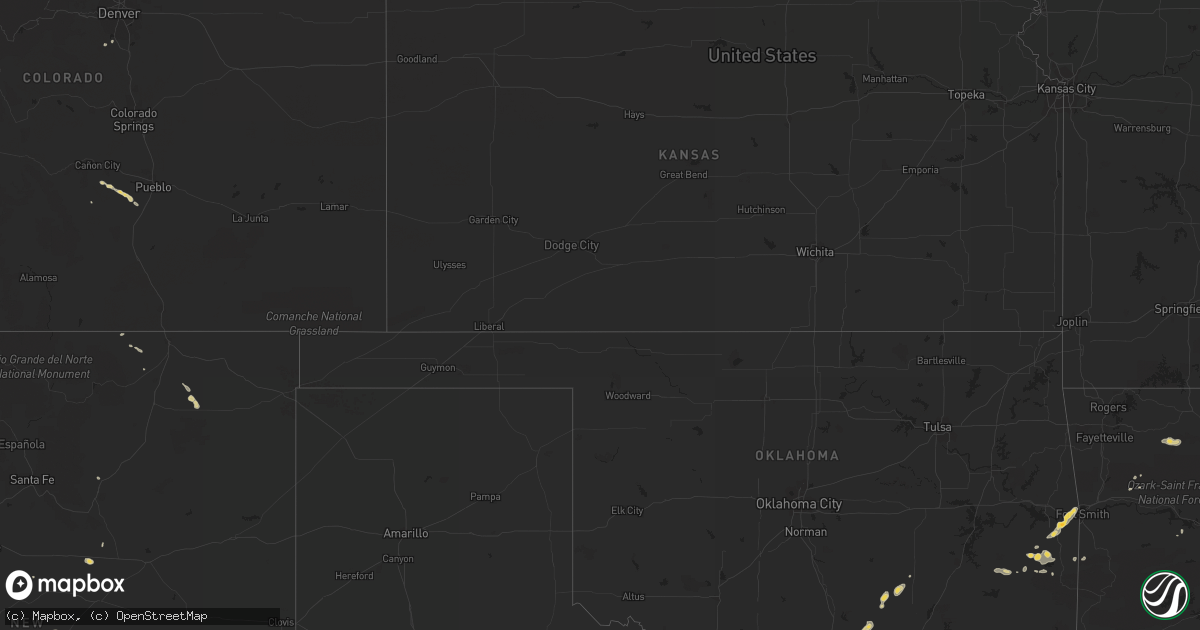
Hail Map on August 9, 2013
Get this storm
August 9 map
$229
one time, instant access
Download today. No call, no setup
Keep the $229
Bought the map and want the full workflow? Apply the entire $229 to a subscription within 7 days. None of it is wasted.
Every map, not just this one
This buys you this map. Subscription and you get every map we run, in the markets you choose from a few cities to whole states to nationwide. Plus real-time alerts the moment a storm fires.
Contact data
Name, contact info, occupancy, even credit band for addresses in the footprint. You go from where it hit to who to call.
Become the source they trust
Unlimited branding weather history reports on demand. You already have the documented answer ready for the property owner, and you are the one who showed up with it.
Property data and RoofTrace estimates
Pull up any address you have got, its value and the exact code rules for that jurisdiction, straight from One Click Code. Then RoofTrace estimates the squares, pitch, and roof value, priced the way you price.
States Impacted by Hail Map on August 9, 2013
Storm reports
Texas
| Date | Description |
|---|---|
| 08/09/20136:08 PM CDT | A local report indicates 61 MPH wind near 8 SW MIDLAND |
| 08/08/20138:26 PM CDT | 60 mph wind gust reported by dfw airport asos |
| 08/08/20138:11 PM CDT | 60 mph wind gust reported by dfw airport asos |
Colorado
| Date | Description |
|---|---|
| 08/09/20134:50 PM CDT | A local report indicates 1.00 inch wind near 3 N ROXBOROUGH PARK |
| 08/08/20138:18 PM CDT | A local report indicates 1.00 inch wind near 5 WSW WALSENBURG |
Illinois
| Date | Description |
|---|---|
| 08/09/20133:01 PM CDT | 2 foot diameter tree down...snapped. |
| 08/09/20132:50 PM CDT | Numerous large trees downed across massac county. Most concentrated damage between joppa and u.s. 45 along county road 900n and crim road. |
South Dakota
| Date | Description |
|---|---|
| 08/09/20136:45 PM CDT | A local report indicates 1.00 inch wind near 14 NW PHILIP |
| 08/09/20135:30 PM CDT | A local report indicates 1.00 inch wind near SHERIDAN LAKE |
| 08/09/20135:30 PM CDT | A local report indicates 60 MPH wind near SHERIDAN LAKE |
| 08/09/20135:30 PM CDT | Several large trees down along sheridan lake road near dakota point. Time estimated from radar. |
| 08/08/20137:25 PM CDT | A local report indicates 60 MPH wind near 13 ESE BEAR BUTTE STATE |
| 08/08/20137:25 PM CDT | A local report indicates 60 MPH wind near 15 NE TILFORD |
| 08/08/20137:05 PM CDT | Wind bent small trees over and shook house |
Montana
| Date | Description |
|---|---|
| 08/08/20138:40 PM CDT | Reports of powerlines and trees down around the clinton area. |
| 08/08/20138:25 PM CDT | A local report indicates 60 MPH wind near 3 NNE LOLO |
| 08/08/20138:06 PM CDT | Multiple power lines down around town |
| 08/08/20138:05 PM CDT | A local report indicates 60 MPH wind near 3 E FLORENCE |
| 08/08/20138:00 PM CDT | There were thirteen phone calls that came into the 911 center related to either power being out or power lines being down due to the wind. |
| 08/08/20137:56 PM CDT | Four cottonwood limbs twelve inches in diameter were down. Tstm wnd gst duration 10 minutes |
Alabama
| Date | Description |
|---|---|
| 08/09/20136:58 PM CDT | A tree was blown down and blocking the roadway near the river south of cordova. |
Nebraska
| Date | Description |
|---|---|
| 08/08/20138:35 PM CDT | Quarter size hail and strong winds with trees bending over. |
| 08/08/20138:30 PM CDT | A local report indicates 1.00 inch wind near BROKEN BOW |
Washington
| Date | Description |
|---|---|
| 08/08/201311:15 PM CDT | Hanford mesonet site hanford 300 area reported a wind gust of 58 mph. Wind gusts of 45 mph or greater occured for 45 minutes. |
| 08/08/201310:20 PM CDT | Spotter reported ping pong ball sized hail nearly covering the ground. Also had heavy rain that caused minor washouts on gravel driveway leading to their house. |
Idaho
| Date | Description |
|---|---|
| 08/09/20135:00 PM CDT | A microburst with estimated 60mph winds blew down 20+ trees around crews on the gold pan fire. Trees blocked roads and crews had to use chainsaws to get out of the area |
Mississippi
| Date | Description |
|---|---|
| 08/09/20131:45 PM CDT | A tree was knocked down on carnation street. A power line was knocked down between main street and jefferson street. |
Maryland
| Date | Description |
|---|---|
| 08/09/20136:36 PM CDT | Tree knocked down near intersection of charles st. And rogers mill pl |
| 08/09/20136:29 PM CDT | Tree down near 23245 spalding lane |
| 08/09/20136:20 PM CDT | Tree down near 42476 clover hill rd |
| 08/09/20135:42 PM CDT | Tree down near intersection of riverside rd and maryland point rd |
| 08/08/20137:55 PM CDT | Tree down along springhill newtown road |
| 08/08/20137:40 PM CDT | Tree down along crain hwy |
| 08/08/20137:34 PM CDT | Trees down on power lines on bishopville rd |
| 08/08/20137:30 PM CDT | Tree down along bel alton newtown road |
Oklahoma
| Date | Description |
|---|---|
| 08/09/20136:40 PM CDT | Estimated 50-60 mph gusts |
| 08/09/20136:25 PM CDT | A local report indicates 1.75 inch wind near OVERBROOK |
| 08/09/20136:19 PM CDT | Quarter to half dollar hail |
| 08/09/20136:15 PM CDT | A local report indicates 1.50 inch wind near 5 S ARDMORE |
| 08/09/20135:22 PM CDT | Trees and power lines down |
| 08/09/20135:15 PM CDT | 72 mph thunderstorm wind gust measured at the wister mesonet site. |
| 08/09/20135:15 PM CDT | Trees and power lines down in wister |
| 08/09/20135:10 PM CDT | 58 mph thunderstorm gust measured at the wister mesonet site. |
Wyoming
| Date | Description |
|---|---|
| 08/09/20136:03 PM CDT | A local report indicates 60 MPH wind near 1 S BAR NUNN |
North Carolina
| Date | Description |
|---|---|
| 08/09/20135:25 PM CDT | Tree down |
| 08/09/20134:45 PM CDT | A two story farmhouse damaged. Several trees down around the property. Tin blown from the roof 1500 feet across a soybean field. |
| 08/09/20134:35 PM CDT | A large tree blown down onto a house on semper fidelis road. Multiple trees blown down on jennings road. |
Oregon
| Date | Description |
|---|---|
| 08/09/20136:00 PM CDT | Strong wind gust blew several shingles off of roof near marion bridge. Time was estimated |
| 08/08/20139:00 PM CDT | At least 10 or more trees down from tstm winds including one snapped 15-20 ft agl...lying mostly on the side of the highway. |
| 08/08/20139:00 PM CDT | At least 10 or more trees down from tstm winds including one snapped 15-20 ft agl...lying mostly on the side of the highway. |
Kentucky
| Date | Description |
|---|---|
| 08/09/20135:13 PM CDT | Strong winds from a thunderstorm toppled a tree onto some power lines. |
| 08/09/20134:02 PM CDT | A local report indicates 58 MPH wind near FRANCES |
| 08/09/20134:00 PM CDT | Late report. Tree down blocking ky hwy 70 near mill road. |
| 08/09/20133:42 PM CDT | Coons chapel road |
Louisiana
| Date | Description |
|---|---|
| 08/09/20133:53 PM CDT | Relayed report from facebook of a large tree limb snapped off. |
Florida
| Date | Description |
|---|---|
| 08/09/20135:20 PM CDT | Trained spotter estimated 70 mph winds in oldsmar area. Time estimated by radar. |
| 08/09/20135:18 PM CDT | Tree down on benjamin rd just north of barry ave. Fire dept. And sherrifs on scene. |
| 08/09/20135:15 PM CDT | Minor roof damage to aluminum lanai. Time estimated by radar. |
| 08/09/20135:15 PM CDT | Tree down just east of tampa airport near lois ave and ohio ave. Time estimated by radar. |
| 08/09/20135:15 PM CDT | Trained spotter reports numerous 3-4 inch tree branches down on benjamin rd just north of sligh ave. Also a power pole and wires are leaning into a tree. |
| 08/09/20132:30 PM CDT | Highlands emergenecy manager reported roof damage to 6 or 7 homes in lake josephine. One home on leona dr. Is missing the majority of its roof. Trees...powerlines...and |
| 08/09/20131:55 PM CDT | Cape coral police department reported a couple of downed trees in the veterans parkway and skyline boulevard area. Time estimated off radar velocities. |
New York
| Date | Description |
|---|---|
| 08/09/20134:30 PM CDT | 5 trees snapped or uprooted at a residence. |
| 08/09/20132:10 PM CDT | A tree fell on wires on bernard street in fort salonga. |
Arkansas
| Date | Description |
|---|---|
| 08/09/20134:35 PM CDT | Tree reported down on highway 65. |
| 08/08/20137:50 PM CDT | Alot of small hail falling with several stones being the size of quarters. |
New Mexico
| Date | Description |
|---|---|
| 08/09/20134:45 PM CDT | Route 246 around mile post 14 half dollar size hail fell probably from 345 to 4 pm |
| 08/09/20134:00 PM CDT | A local report indicates 1.00 inch wind near 4 N TIJERAS |
| 08/09/20133:22 PM CDT | Frost road and highway 14 |
| 08/09/20132:40 PM CDT | A local report indicates 1.00 inch wind near 1 SW SANDIA PARK |
Cities Impacted by Hail Map on August 9, 2013
- Lysite, WY
- Stevenson, WA
- Cedar Crest, NM
- Sandia Park, NM
- Capitan, NM
- Goldendale, WA
- Lyle, WA
- Wahkiacus, WA
- Appleton, WA
- Glenwood, WA
- Diamond, OR
- Princeton, OR
- Dexter, NM
- Florence, AL
- Helmville, MT
- Casper, WY
- Wister, OK
- Bigfork, MT
- Florence, CO
- Bowie, TX
- Montague, TX
- Saint Jo, TX
- Forestburg, TX
- Mechanicsville, MD
- Odessa, TX
- Smithland, KY
- Salem, KY
- Marion, KY
- Burna, KY
- Strawn, TX
- Graford, TX
- Jamestown, KY
- Burkesville, KY
- Russellville, KY
- Olmstead, KY
- Adairville, KY
- Pueblo, CO
- Bridgeport, TX
- Garden City, TX
- Fifty Six, AR
- Mountain View, AR
- Timbo, AR
- Onia, AR
- Sulligent, AL
- Nashville, TN
- Brewster, NE
- Shoup, ID
- Sterling City, TX
- Jacksboro, TX
- Tupelo, OK
- Allen, OK
- Marshall, AR
- Saint Joe, AR
- Tekoa, WA
- Palo Pinto, TX
- Marietta, OK
- Ardmore, OK
- Overbrook, OK
- Broken Bow, NE
- Anselmo, NE
- Beulah, CO
- Wetmore, CO
- White Salmon, WA
- Rosalia, WA
- Wanblee, SD
- Big Spring, TX
- Compton, AR
- Ponca, AR
- Kingston, AR
- Wall, SD
- Bokeelia, FL
- Saint James City, FL
- Whitman, NE
- Condon, MT
- Georgetown, DE
- Ruskin, FL
- Agness, OR
- Soap Lake, WA
- Ephrata, WA
- Spiro, OK
- Sturgis, SD
- Calvin, OK
- Bowling Green, KY
- Midwest, WY
- Midkiff, TX
- Rock Island, WA
- Cody, NE
- Valentine, NE
- Calico Rock, AR
- Melbourne, AR
- Muldrow, OK
- Roland, OK
- Hattieville, AR
- Solgohachia, AR
- Morrilton, AR
- New Iberia, LA
- Wilbur, WA
- Springfield, AR
- Glenrock, WY
- Fort Sumner, NM
- New Hope, AL
- Crystal River, FL
- Dunnellon, FL
- Beverly Hills, FL
- Springer, NM
- Anna Maria, FL
- Dardanelle, AR
- Brandon, MS
- Roundhill, KY
- Jerusalem, AR
- Roswell, NM
- Tishomingo, OK
- Mill Creek, OK
- Townsend, MT
- Adams, TN
- Cedar Hill, TN
- Deary, ID
- Littleton, CO
- Klickitat, WA
- Franklin, AL
- Madill, OK
- Mannsville, OK
- Saint Ignatius, MT
- Hayden, ID
- Loudon, TN
- Wilburton, OK
- Davenport, WA
- Westcliffe, CO
- Red Oak, OK
- Delaware, AR
- Stonewall, OK
- Gainesville, TX
- Bokoshe, OK
- Wenatchee, WA
- Hartford, AR
- Ronan, MT
- Chattaroy, WA
- Colbert, WA
- Mead, WA
- Tremont, MS
- Seneca, NE
- Buckley, WA
- Broussard, LA
- Saint Martinville, LA
- Tryon, NE
- Chico, TX
- Merryville, LA
- Taiban, NM
- Hagerman, NM
- Drummond, MT
- Leslie, AR
- Franklin, KY
- Wisdom, MT
- Fairfield, WA
- Latah, WA
- Cleveland, AR
- Talihina, OK
- Warm Springs, OR
- Vaughn, NM
- Ozark, AR
- Scotland, AR
- Oakland, KY
- Hot Springs, MT
- Jasper, AR
- Enterprise, OR
- Leighton, AL
- Dixon, MT
- Smithville, AR
- Strawberry, AR
- Pilot Rock, OR
- Atkins, AR
- Golconda, IL
- Metropolis, IL
- Tampa, FL
- Plumerville, AR
- Oakridge, OR
- Government Camp, OR
- Rathdrum, ID
- Trout Lake, WA
- Newman Lake, WA
- Post Falls, ID
- Hall, MT
- Charlo, MT
- Elida, NM
- Bridgeville, DE
- Greenwood, DE
- Yazoo City, MS
- Lonepine, MT
- Belmont, MS
- Leonardtown, MD
- California, MD
- Hollywood, MD
- Merna, NE
- Big Flat, AR
- Centrahoma, OK
- Kendrick, ID
- Mccurtain, OK
- Groveland, FL
- Hardin, MT
- Monahans, TX
- Barstow, TX
- Deridder, LA
- Clinton, MT
- Cord, AR
- Bellefontaine, MS
- Eupora, MS
- Spokane, WA
- Charlotte Hall, MD
- Bonner, MT
- Polson, MT
- Poteau, OK
- Heavener, OK
- Burnsville, MS
- Glen, MS
- Gallatin, TN
- Cle Elum, WA
- Thorp, WA
- Muenster, TX
- Palisades, WA
- Sophia, NC
- Trinity, NC
- Shady Point, OK
- Enumclaw, WA
- Pulaski, TN
- Scottsville, KY
- Lafayette, LA
- Duson, LA
- Sidney, AR
- Mount Pleasant, AR
- Desmet, ID
- Gold Creek, MT
- Deer Lodge, TN
- Otis Orchards, WA
- Laurel, DE
- Seaford, DE
- Philadelphia, TN
- Booneville, MS
- Macon, MS
- Blue River, OR
- Hermitage, TN
- Jal, NM
- Spangle, WA
- Canton, MS
- Pickens, MS
- Corinth, MS
- Michie, TN
- Counce, TN
- Iuka, MS