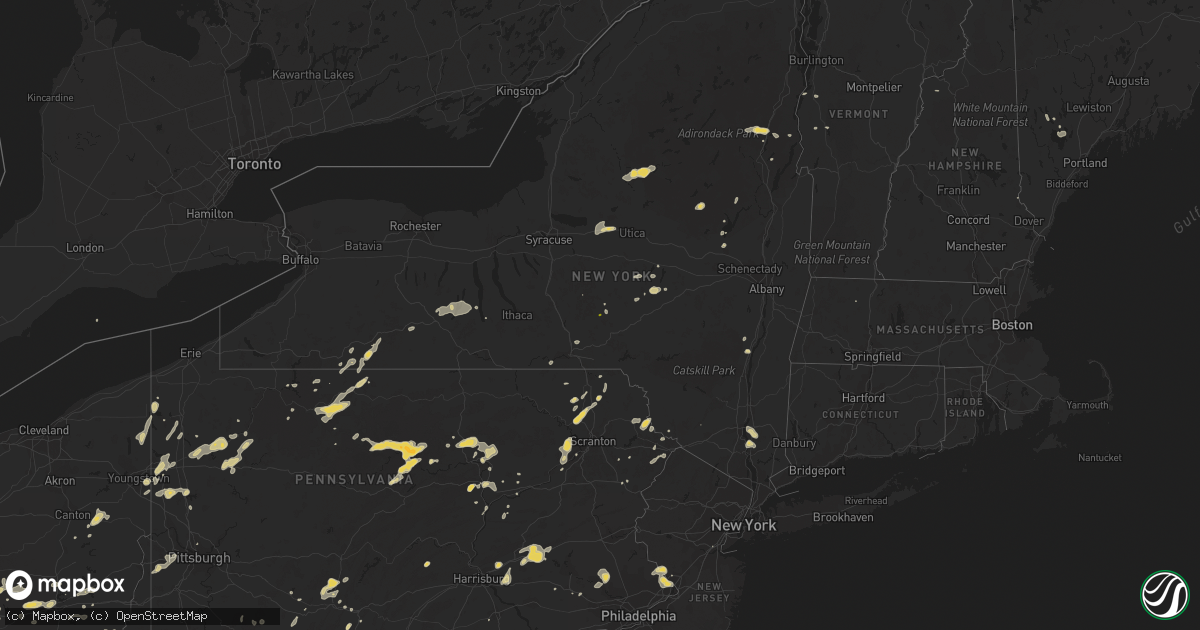
Hail Map on August 9, 2012
Get this storm
August 9 map
$229
one time, instant access
Download today. No call, no setup
Keep the $229
Bought the map and want the full workflow? Apply the entire $229 to a subscription within 7 days. None of it is wasted.
Every map, not just this one
This buys you this map. Subscription and you get every map we run, in the markets you choose from a few cities to whole states to nationwide. Plus real-time alerts the moment a storm fires.
Contact data
Name, contact info, occupancy, even credit band for addresses in the footprint. You go from where it hit to who to call.
Become the source they trust
Unlimited branding weather history reports on demand. You already have the documented answer ready for the property owner, and you are the one who showed up with it.
Property data and RoofTrace estimates
Pull up any address you have got, its value and the exact code rules for that jurisdiction, straight from One Click Code. Then RoofTrace estimates the squares, pitch, and roof value, priced the way you price.
States Impacted by Hail Map on August 9, 2012
Storm reports
New Jersey
| Date | Description |
|---|---|
| 08/09/20124:19 PM CDT | Trees down |
| 08/09/20124:13 PM CDT | Window damaged at control tower at mercer county airport. Trees also down on train tracks in trenton. |
| 08/09/20121:55 PM CDT | Trees down |
Florida
| Date | Description |
|---|---|
| 08/09/20123:00 PM CDT | Power lines down on east paniel road. |
South Carolina
| Date | Description |
|---|---|
| 08/09/20126:58 PM CDT | Sc highway patrol reported a tree down on sc hwy 601 in furman. |
| 08/09/20126:48 PM CDT | Sc highway patrol reported a tree down at n jacob smart blvd and n green st. |
| 08/09/20126:39 PM CDT | Sc highway patrol reported a tree down at sc hwy 119 and sand hills rd. |
| 08/09/20125:57 PM CDT | Newberry sheriff office reported a tree down on a house in chappells. Considerable roof damage. No injuries. |
| 08/09/20125:57 PM CDT | Trees and power lines down at sc highway 34 and old landfill rd |
| 08/09/20124:48 PM CDT | Tree down near mile marker 10 off i-385 near the intersection with hwy 221. |
| 08/09/20124:40 PM CDT | Trees blown down at highway 101 and donahue rd |
| 08/09/20124:40 PM CDT | A tree fell on a power line on hilltop road. |
| 08/09/20124:35 PM CDT | Power lines and limbs down |
| 08/09/20124:35 PM CDT | Trees blown down |
| 08/09/20124:30 PM CDT | Trees blown across the road at crain and donahue |
| 08/09/20124:13 PM CDT | Large limbs blown down and 1/2 inch hail |
| 08/09/20123:58 PM CDT | Large limbs blown down |
| 08/09/20123:45 PM CDT | One large limb blown down on dillard road. |
| 08/09/20123:45 PM CDT | One power line down on reid school rd near edwards mill rd. |
| 08/09/20123:43 PM CDT | Several trees and lines down including along blacks drive...hudson farm road and shannon lake circle. |
| 08/09/20123:42 PM CDT | Trees down across 2 vehicles and blocking the north bound lanes of i-85 at mile marker 52. |
| 08/09/20123:14 PM CDT | Multiple large tree limbs blown down and some urban flooding |
| 08/09/20123:14 PM CDT | Two reports of trees down on power lines near the fox run country club on hunter road. |
| 08/09/20122:50 PM CDT | Law enforcement reported a tree in the roadway. Time estimated by radar. |
| 08/09/20122:50 PM CDT | Law enforcement reported power lines and trees blocking the road. Time estimated by radar. |
| 08/08/20127:50 PM CDT | Trees down on mineral springs rd at shoal creek rd |
Kentucky
| Date | Description |
|---|---|
| 08/09/20124:15 PM CDT | A local report indicates 61 MPH wind near 8 N CYNTHIANA |
| 08/09/20124:15 PM CDT | Trees blown down by thunderstorm winds. |
| 08/09/20123:55 PM CDT | A tree was reported down on the west side of prestonsburg. |
| 08/09/20123:45 PM CDT | A tree was reported down on route 1428. |
| 08/09/20123:38 PM CDT | A local report indicates 1.75 inch wind near 6 SSW CLARYVILLE |
| 08/09/20123:13 PM CDT | Trees reported down. |
| 08/09/20123:05 PM CDT | Trees were blown down by thunderstorm winds. |
| 08/09/20123:03 PM CDT | Large trees down |
| 08/09/20123:03 PM CDT | Dime to quarter size hail. Also estimated winds in excess of 50 mph. |
| 08/09/20122:55 PM CDT | A tree reported down. |
| 08/09/20122:52 PM CDT | Near southland drive. |
| 08/09/20121:55 PM CDT | Some trees reported down. |
| 08/09/201212:12 PM CDT | One tree down on hwy 89s in the indian creek area. |
| 08/09/201211:41 AM CDT | Trees blown across road on leaf lane. |
| 08/09/201211:15 AM CDT | Trees down near the climax community. |
Ohio
| Date | Description |
|---|---|
| 08/09/20126:25 PM CDT | A local report indicates 1.00 inch wind near OXFORD |
| 08/09/20126:20 PM CDT | Tree down in electric lines on sr216. |
| 08/09/20126:10 PM CDT | Tree down along county route 84. |
| 08/09/20126:00 PM CDT | Power lines down |
| 08/09/20125:50 PM CDT | Trees down along route 93 near community of bristol. Time estimated from radar. |
| 08/09/20125:50 PM CDT | Power lines down |
| 08/09/20125:50 PM CDT | Trees and powerlines down at 575 black gold rd. |
| 08/09/20125:47 PM CDT | Tree down on sr124 near mile marker 23. |
| 08/09/20125:36 PM CDT | A local report indicates 1.00 inch wind near CAMBRIDGE |
| 08/09/20125:25 PM CDT | Trees down |
| 08/09/20125:20 PM CDT | Trees down on cross rd and coon hill rd. Numerous other trees down in the area between seaman and west union. |
| 08/09/20125:15 PM CDT | Tree down on sr785. |
| 08/09/20124:52 PM CDT | One tree limb down. |
| 08/09/20124:50 PM CDT | Numerous tree branches down by thunderstorm winds. |
| 08/09/20124:49 PM CDT | A local report indicates 1.75 inch wind near 5 SSE WILMINGTON |
| 08/09/20124:47 PM CDT | Quarter sized hail reported in minerva. |
| 08/09/20124:41 PM CDT | Tree down near intersection of walnut and minor streets. |
| 08/09/201212:24 AM CDT | A local report indicates 58 MPH wind near 2 E RISINGSUN |
| 08/08/20128:15 PM CDT | Several reports of golf ball-sized hail. |
| 08/08/20128:08 PM CDT | Quarter size hail in the town of howard. |
| 08/08/20128:05 PM CDT | Several reports of golf ball-sized hail. |
| 08/08/20127:40 PM CDT | Trees and wires down. Time estimated by radar. |
Georgia
| Date | Description |
|---|---|
| 08/09/20126:34 PM CDT | Columbia county sheriff reported tree down on stevens creek road and old stevens creek road. |
| 08/09/20126:26 PM CDT | Tree down on milledge rd at battle row |
| 08/09/20126:26 PM CDT | Large tree limbs down on washington rd at bertram rd |
| 08/09/20125:35 PM CDT | Trees down on leonard circle in waynesboro |
| 08/09/20125:35 PM CDT | One tree down on powerline along the intersection of eb cooper highway and thompson hunting club. |
| 08/09/20125:22 PM CDT | One tree down along the intersection of highway 196 and wells cemetery road. |
| 08/09/20125:17 PM CDT | One tree down on powerline along wells road. |
| 08/09/20125:17 PM CDT | One tree reported down along elim church road. |
| 08/09/20125:05 PM CDT | A spotter reported two trees were blown down into the power lines. The time of the report was based on radar. |
| 08/09/20124:57 PM CDT | A spotter reported power lines and trees were blown down in the jesup area. The time of damage was estimated based on radar. |
| 08/09/20124:50 PM CDT | Trees and power lines were blown down in the jesup city limits. The time of damage was estimated based on radar data. |
| 08/09/20124:37 PM CDT | Monroe county 911 relayed reports of several downed trees in the eastern portion of the county. Most of the trees have been cleared from roads...but one large tree stil |
| 08/09/20122:58 PM CDT | Pulaski county emergency management relayed reports of 2 downed trees and several downed power lines in and just east of the hawkinsville area. Time estimated off radar |
| 08/09/20121:54 PM CDT | Two trees down across the southern portion of the county. Time estimated by radar. |
| 08/09/20121:47 PM CDT | One tree down on mud creek road. Time estimated by radar. |
Mississippi
| Date | Description |
|---|---|
| 08/09/20124:25 PM CDT | A few out buildings were damaged and a number of trees were blown down. |
| 08/09/20124:25 PM CDT | At least four trees were downed across lamar county |
| 08/09/20124:07 PM CDT | Update to tstm wind damage report at st. Francis animal sanctuary. Tornado with estimated winds of 85 mph was embedded in larger area of downburst winds. Damage path le |
| 08/09/20123:50 PM CDT | Trees downed along graves road...blocking the road |
| 08/09/20123:50 PM CDT | Trees downed along monroe road and rainey road |
| 08/09/20123:45 PM CDT | Tree downed at the intersection of us highway 49 and ms highway 598. |
| 08/09/20123:30 PM CDT | Observed at hattiesburg municipal airport |
| 08/09/20123:30 PM CDT | Trees downed along james street. Pea sized hail was also reported. |
| 08/09/20123:20 PM CDT | Trees downed at elks lake rd and homestead near the dixie community. Roof was damaged at a multi-purpose building. |
| 08/09/20123:20 PM CDT | Trees downed on leaf avenue in prentiss...highway 42 w between new hebron and prentiss...and hill road west of prentiss |
| 08/09/20122:00 PM CDT | 4 to 5 trees downed blocking roadways around rankin county...including in the brandon and cleary areas. |
| 08/09/201211:24 AM CDT | Wind damage to barn and surrounding structures between highway 43 and highway 11 near mcneil. Radar signature indicative of a downburst between 1119 and 1124 cdt. |
Indiana
| Date | Description |
|---|---|
| 08/09/20126:55 PM CDT | Estimated 60 mph winds accompanied by nickel size hail. |
| 08/09/20126:52 PM CDT | 3 blocks from the center of morocco...hail ranged from golfball to baseball sized. |
| 08/09/20126:38 PM CDT | Time estimated...based on radar. |
| 08/09/20126:35 PM CDT | Report relayed via tv media. Time estimated from radar. |
| 08/09/20126:19 PM CDT | Reported via media facebook page. Hail size estimated from photo and time estimated from radar. |
| 08/09/20126:07 PM CDT | Hail 1.50 to 2.25 inches in diameter caused damage to cars and roofs. Trees and tree limbs were downed by thunderstorm gusts. Time estimated...based on radar. |
| 08/09/20126:07 PM CDT | Hail 1.50 to 2.25 inches in diameter caused damage to cars and roofs. Trees and tree limbs were downed by thunderstorm gusts. Time estimated...based on radar. |
| 08/09/20123:00 PM CDT | Tree reported down on a house. |
| 08/09/20122:49 PM CDT | Several trees down. |
| 08/09/20122:39 PM CDT | Hail larger than a quarter and smaller than golf balls reported. |
| 08/09/20122:36 PM CDT | Hail larger than a quarter and smaller than golf balls reported. |
| 08/08/20129:45 PM CDT | Tree on car on w broadway street and tree on house on north street. Time estimated from radar. |
| 08/08/20129:04 PM CDT | Quarter sized hail at the intersection of sr105 and division rd. |
| 08/08/20129:01 PM CDT | Estimated 60 mph thunderstorm gust as well as pea size hail from trained storm spotter. |
| 08/08/20128:50 PM CDT | Estimated 50 to 60 mph wind and unknown size hail on cr 600e |
| 08/08/20128:40 PM CDT | Measured after the event. Hail ranged from half inch to 1.5 inch in diameter. |
| 08/08/20128:35 PM CDT | Delayed report. Time estimated. |
| 08/08/20128:34 PM CDT | Delayed report. Time estimated. |
| 08/08/20128:28 PM CDT | Trees downed in reelsville. Late report. |
| 08/08/20128:24 PM CDT | Time estimated...based on radar. |
| 08/08/20128:23 PM CDT | Quarter size hail at the homewood suites from 907-923 pm. |
| 08/08/20128:17 PM CDT | Hail lasted nearly 10 minutes...ending at 917 pm edt. |
| 08/08/20128:15 PM CDT | A local report indicates 1.50 inch wind near PLAINFIELD |
| 08/08/20128:12 PM CDT | Accompanied by 50 mph winds. |
| 08/08/20128:12 PM CDT | Reported near radnor. |
| 08/08/20128:11 PM CDT | A local report indicates 1.00 inch wind near 2 NNW PLAINFIELD |
| 08/08/20128:11 PM CDT | A local report indicates 1.50 inch wind near 2 W PLAINFIELD |
| 08/08/20128:10 PM CDT | Nickel to quarter size hail. |
| 08/08/20128:09 PM CDT | A local report indicates 1.00 inch wind near 2 W PLAINFIELD |
| 08/08/20128:07 PM CDT | Quarter size hail at us highway 40 and cartersburg road. |
| 08/08/20128:05 PM CDT | Hail now over 2 inches in diameter just north of flora at 50 e and 100 n. |
| 08/08/20128:05 PM CDT | Quarter sized hail damaged shingles and shredded leaves. |
| 08/08/20128:05 PM CDT | Time estimated...based on radar. |
| 08/08/20128:05 PM CDT | Winds estimated to at least 60 mph just north of flora at 50 e and 100 n. |
| 08/08/20128:03 PM CDT | Quarter size hail just north of flora at 50 e and 100 n. |
| 08/08/20128:02 PM CDT | Quarter to half dollar sized hail half way between ambia and boswell. |
| 08/08/20128:00 PM CDT | Many small limbs downed. Accompanied by heavy rainfall measuring 1.01 inches in 30 minutes. |
| 08/08/20127:50 PM CDT | Tree limbs 2-3 inches in diameter and powerlines down along cr 700 s. |
| 08/08/20127:38 PM CDT | A local report indicates 1.00 inch wind near WOLCOTT |
| 08/08/20127:30 PM CDT | A local report indicates 1.75 inch wind near REMINGTON |
| 08/08/20127:27 PM CDT | Also dime sized hail. |
| 08/08/20127:27 PM CDT | Near mile marker 205 on interstate 65. Relayed by sheriff. |
| 08/08/20127:25 PM CDT | Relayed by sheriff |
| 08/08/20127:24 PM CDT | Trees and tree limbs down. One tree was down on a garage. Time estimated...based on radar. |
| 08/08/20127:18 PM CDT | Hail ranged from quarter to half dollar sized. |
| 08/08/20127:10 PM CDT | Hail larger than quarters accumulated to 1.5 inches deep reported in romney. Time estimated from radar. |
| 08/08/20127:09 PM CDT | Reported via media facebook page. |
| 08/08/20127:07 PM CDT | Trees down on powerlines at 933 e cr 1050 s. Time estimated from radar. |
| 08/08/20127:03 PM CDT | Estimated 60 mph winds accompanied by nickel size hail. |
North Carolina
| Date | Description |
|---|---|
| 08/09/20125:59 PM CDT | Trees and power lines down on spainhour rd and along 181. |
| 08/09/20125:19 PM CDT | Trees down throughout the area |
| 08/09/20122:07 PM CDT | One tree down off south mills river rd in the town of mills river. |
| 08/09/20122:04 PM CDT | One tree down near the intersection of big willow rd and declaration lane. |
Arkansas
| Date | Description |
|---|---|
| 08/09/20125:50 PM CDT | Tree limbs were blown down onto a power line...which caused an outage. |
| 08/09/20121:40 AM CDT | Quarter size hail fell in magnolia. |
| 08/09/201212:35 AM CDT | Large tree down across hwy. 15 southwest of el dorado in the three creeks area. |
| 08/09/201212:10 AM CDT | Several trees downed east of town along hwy. 98 and county road 34. |
| 08/08/20129:30 PM CDT | Trees down across eastern ashley county...some blocking roads |
| 08/08/20129:30 PM CDT | A local report indicates 1.25 inch wind near 7 E HAMBURG |
| 08/08/20129:20 PM CDT | Several trees downed along us highway 82 between hamburg and montrose...blocking the roadway. |
| 08/08/20128:45 PM CDT | Trees were blown down at cominto. |
| 08/08/20128:32 PM CDT | The monticello municpal airport reported a gust of 63 miles per hour. |
| 08/08/20128:31 PM CDT | Numerous trees are down across the city of monticello. |
| 08/08/20128:06 PM CDT | Trees were blown down. |
New Hampshire
| Date | Description |
|---|---|
| 08/09/20125:18 PM CDT | Three large trees across pearl lake road between lisbon and sugar hill |
| 08/09/20122:43 PM CDT | Large tree and wires down across mckeagney road |
West Virginia
| Date | Description |
|---|---|
| 08/09/20123:29 PM CDT | Downed tree limbs along winchester grade road. |
| 08/09/20123:29 PM CDT | Downed tree limbs along winchester grade road. |
| 08/09/20121:44 PM CDT | One tree down |
| 08/09/201212:47 PM CDT | A local report indicates 1.00 inch wind near MORGANTOWN |
| 08/09/201212:27 PM CDT | Tree down blocking knobley road near rt 48 intersection. |
| 08/09/201212:22 PM CDT | Tree down blocking knobley road near rt 48 intersection. |
| 08/09/201211:35 AM CDT | Trees reported down. |
Minnesota
| Date | Description |
|---|---|
| 08/09/20123:20 PM CDT | 15 inch diameter walnut tree snapped 30 feet above ground. Corn pushed over 45 degrees. Some corn snapped on top. Other trees pushed over. |
Oklahoma
| Date | Description |
|---|---|
| 08/09/20123:40 PM CDT | A local report indicates 69 MPH wind near 1 WNW LANE |
Arizona
| Date | Description |
|---|---|
| 08/09/20126:40 PM CDT | Dolan springs fire department reported 3 power poles were knocked down in dolan springs by wind from a thunderstorm. |
| 08/09/20125:50 PM CDT | Thunderstorm winds blew trampolines into power lines in peach springs. |
| 08/08/20129:00 PM CDT | Damage to fences and signs from bullhead city to mohave valley. Power was out in old bullhead and in mohave valley. |
| 08/08/20129:00 PM CDT | Power was knocked out in downtown kingman. |
| 08/08/20128:50 PM CDT | Power lines were reported down in golden shores and mohave valley. Visibility between 50 and 500 feet. |
| 08/08/20128:50 PM CDT | Thunderstorm outflow winds caused several tents to collapse during a party at the community park in bullhead city. The wind also knocked over several portable toilets a |
| 08/08/20128:46 PM CDT | 69 mph gust reported at bullhead city cw4367 mesonet station. |
| 08/08/20128:15 PM CDT | A spotter reported 2 big trees down in the sams club parking lot in bullhead city. One car windshield was broken out. |
| 08/08/20128:00 PM CDT | Bullhead city police department reported numerous power lines down and power poles knocked down. Power was out to a considerable portion of bullhead city. Roofs were ta |
| 08/08/20127:58 PM CDT | A spotter measured a 68 mph wind gust at a home weather station. The wind was showing a steady period of 50 to 55 mph. The wind knocked over a large mesquite tree and p |
Nevada
| Date | Description |
|---|---|
| 08/08/201210:10 PM CDT | Tikaboo peak mesonet site measured a 59 mph thunderstorm wind gust. |
| 08/08/20129:25 PM CDT | Thunderstorm with heavy rain with some ponding of water on local streets. Small branches broken on nearby trees. |
| 08/08/20129:24 PM CDT | Remote sensor west of ragtown near highway 50 reported south winds at 25g77 mph. |
| 08/08/20128:15 PM CDT | Power was knocked out to residential neighborhoods on the north side of laughlin. The event time is an estimate. |
| 08/08/20128:00 PM CDT | An 8 by 12 foot window was blown out of the riverside casino. |
Pennsylvania
| Date | Description |
|---|---|
| 08/09/20126:50 PM CDT | Tree down. |
| 08/09/20126:30 PM CDT | Trees and wires down. |
| 08/09/20126:25 PM CDT | Trees down blocking road |
| 08/09/20126:23 PM CDT | Trees down |
| 08/09/20126:14 PM CDT | A local report indicates 1.00 inch wind near 2 E NEW CASTLE |
| 08/09/20126:10 PM CDT | Quarter-sized hail observed for 30 seconds. |
| 08/09/20126:10 PM CDT | Tree on mobile home. No injuries. |
| 08/09/20126:10 PM CDT | Trees and wires down in western berks county. |
| 08/09/20126:09 PM CDT | A local report indicates 1.00 inch wind near OIL CITY |
| 08/09/20126:09 PM CDT | Trees and power lines down |
| 08/09/20126:04 PM CDT | A local report indicates 1.00 inch wind near SENECA |
| 08/09/20126:04 PM CDT | Trees down |
| 08/09/20126:00 PM CDT | Trees down. |
| 08/09/20125:50 PM CDT | Trees down |
| 08/09/20125:45 PM CDT | Trees down. |
| 08/09/20125:10 PM CDT | Trees down. |
| 08/09/20124:55 PM CDT | Trees down. |
| 08/09/20124:45 PM CDT | Trees down |
| 08/09/20124:45 PM CDT | Multiple trees down roads closed |
| 08/09/20124:45 PM CDT | Trees downed |
| 08/09/20124:22 PM CDT | 100-200yd path of large trees down |
| 08/09/20123:45 PM CDT | Trees down |
| 08/09/20122:36 PM CDT | Trees down |
| 08/09/201212:40 PM CDT | Trees and power lines down on route 44 in hebron township |
| 08/09/201212:00 PM CDT | Tree down on route 146 |
| 08/09/201211:45 AM CDT | Tree down on halsey road |
| 08/08/20128:04 PM CDT | Large branches down |
| 08/08/20128:00 PM CDT | Wires down. |
| 08/08/20127:54 PM CDT | Trees down |
| 08/08/20127:45 PM CDT | Trees down on lexington drive. |
| 08/08/20127:40 PM CDT | Trees down |
| 08/08/20127:30 PM CDT | Tree down. |
| 08/08/20127:18 PM CDT | Trees down at west center road and maple road. |
| 08/08/20127:11 PM CDT | Reports of several downed trees. |
| 08/08/20127:11 PM CDT | Reports of several downed trees. |
| 08/08/20127:10 PM CDT | Trees down. |
Wisconsin
| Date | Description |
|---|---|
| 08/09/20121:45 PM CDT | Hail damage to crops...corn completely stripped..soy beans stripped and flattened for a 5 mile long 1.5 mile wide patch. |
| 08/09/201212:20 PM CDT | Occurred at nelson lake. |
Delaware
| Date | Description |
|---|---|
| 08/09/201212:55 PM CDT | Trees down |
Iowa
| Date | Description |
|---|---|
| 08/09/20126:55 PM CDT | Multiple trees down in town. |
| 08/09/20126:48 PM CDT | Mostly small hail...but a few stones were up to the size of quarters. Delayed report. Time estimated from radar. |
| 08/09/20126:40 PM CDT | A local report indicates 1.00 inch wind near GREENE |
| 08/09/20125:10 PM CDT | Cooperative observer measured up to quarter size hail. Drifts of hail in road ditch and the corn was stripped of the leaves with stalks and ears left. |
| 08/09/20125:10 PM CDT | Calmar fire department estimated a wind gust of 70 miles per hour. |
| 08/09/20125:05 PM CDT | A local report indicates 70 MPH wind near CONOVER |
| 08/09/20124:56 PM CDT | Courtesy kwwl media. Verified with picture. |
| 08/09/20124:56 PM CDT | Quarter to golfball. Dented camper. Wind estimated at 50 mph with leaves sprayed onto side of house. No damage to home siding. |
| 08/09/20124:55 PM CDT | Dime to quarter sized. Also some small branches downed from wind. |
| 08/08/20127:10 PM CDT | Powerlines damaged due to strong thunderstorm winds. Knocked out power at the mall. Time estimated from radar. |
| 08/08/20127:00 PM CDT | Two large branches down along with damage to soffit on the home. Report delayed. |
| 08/08/20127:00 PM CDT | Multiple trees down in rural areas between marengo and williamsburg. Time estimated by radar. |
Illinois
| Date | Description |
|---|---|
| 08/09/20126:55 PM CDT | Reported at the edgar county airport |
| 08/09/20126:35 PM CDT | Swop report of three large trees down. |
| 08/09/20126:33 PM CDT | Three power poles snapped and tree limbs blown down |
| 08/09/20126:26 PM CDT | 2690 south 13000 east road. |
| 08/09/20126:15 PM CDT | Grain silo with dents...some structure damage...trees blown down |
| 08/09/20126:07 PM CDT | Tree limbs blown down |
| 08/09/20126:06 PM CDT | Tree limbs blown down |
| 08/09/20126:06 PM CDT | Trees topped...corn field blown down...power lines blown down |
| 08/09/20126:05 PM CDT | Ten train cars derailed by thunderstom wind gust |
| 08/09/20124:54 PM CDT | A local report indicates 1.00 inch wind near 1 E FAIRBURY |
| 08/09/20124:50 PM CDT | Some trees down on farm. |
| 08/09/20124:50 PM CDT | Quarter sized hail fell on farm for 10 minutes...ending at about 500 pm. Hail covered the ground. |
| 08/09/20124:35 PM CDT | Measured 65 mph wind gust |
| 08/09/20124:35 PM CDT | A local report indicates 1.00 inch wind near 3 S PONTIAC |
| 08/09/20124:30 PM CDT | Swop report. |
| 08/09/20124:25 PM CDT | Trees blown down...relayed by illinois state police |
| 08/09/20124:25 PM CDT | 1.5 inch hail...relayed by illinois state police |
| 08/09/20124:25 PM CDT | A local report indicates 1.00 inch wind near 3 SW BLOOMINGTON |
| 08/09/20124:20 PM CDT | At caseys general store in flanagan. |
| 08/09/20123:54 PM CDT | A local report indicates 1.00 inch wind near RUTLAND |
| 08/09/20123:35 PM CDT | A local report indicates 1.00 inch wind near WENONA |
| 08/09/20123:35 PM CDT | Trees and powerlines blown down |
| 08/09/20123:35 PM CDT | A local report indicates 1.00 inch wind near TOLUCA |
| 08/09/20123:05 PM CDT | 12 inch diameter tree blown down on state street....powerline down and road blocked |
| 08/08/20127:30 PM CDT | Estimated pea and quarter sized hail outside the dollar general at 15 south axtel avenue. |
Louisiana
| Date | Description |
|---|---|
| 08/09/20126:55 PM CDT | Trees and powerlines down on west bank of lake saint joseph from 1.5 miles south of newellton to 3 miles south of newellton. Radar analysis and damage suggests localize |
| 08/09/20121:34 PM CDT | Damage to fencing and small objects 5400 block of tusa drive. Also some images available from twitter and media.radar signature strongly suggestive of a wet microburst |
| 08/09/20121:15 PM CDT | Trees and power lines were knocked down. Time estimated based on radar. |
| 08/09/20126:06 AM CDT | Sheriffs dept reports tree down on powerlines at intersection of hwy 1207 and 115. |
| 08/09/20122:00 AM CDT | Tree down in elmer...rapides parish louisiana |
| 08/09/201212:45 AM CDT | A tree was blown down on highway 15 between spearsville and highway 167. |
| 08/08/201211:10 PM CDT | Tree downed on home in east jena |
| 08/08/201210:50 PM CDT | Tree down across hwy 133 |
| 08/08/201210:45 PM CDT | Power lines downed in wildsville |
| 08/08/201210:45 PM CDT | Power lines downed in jonesville |
| 08/08/201210:00 PM CDT | Multiple trees and power lines downed across northern catahoula parish |
| 08/08/20129:53 PM CDT | Multiple trees and power lines down between rayville and mangham |
| 08/08/20129:25 PM CDT | Couple of signs blown down at citgo gas station on highway 4 west. |
| 08/08/20129:25 PM CDT | A local report indicates 1.25 inch wind near MANGHAM |
| 08/08/20129:20 PM CDT | Multiple downed trees blocking la highway 4 |
| 08/08/20129:20 PM CDT | Power lines and large tree limbs down in northern tensas parish |
| 08/08/20129:15 PM CDT | Several trees fell onto roadways and one trailer was damaged by a tree. Power outages were also reported. |
| 08/08/20129:15 PM CDT | In the area near and just south of crowville...trees uprooted...a roof was blown off a trailer...large tree limbs fell through houses...and some windows were blown out. |
| 08/08/20129:10 PM CDT | Widespread trees...power lines...and power poles downed all across franklin parish |
| 08/08/20129:00 PM CDT | Tree fell down on house on 302 jim albert road. |
| 08/08/20129:00 PM CDT | Trees and a power line down across la highway 15 |
| 08/08/20129:00 PM CDT | A local report indicates 70 MPH wind near BASKIN |
| 08/08/20128:56 PM CDT | A local report indicates 1.75 inch wind near ALTO |
| 08/08/20128:55 PM CDT | Multiple trees down across franklin parish |
| 08/08/20128:50 PM CDT | A roof was blown off a trailer at 1839 highway 578. |
| 08/08/20128:40 PM CDT | Hailstones up to golfball size fell mixed with smaller sizes for a few minutes at the bayou macon lounge |
| 08/08/20128:40 PM CDT | Numerous trees and powerlines down with several metal carports blown around along route 577 between bayou macon lounge and waverly |
| 08/08/20128:35 PM CDT | Numerous trees and powerlines down with several metal carports blown around along route 577 between bayou macon lounge and waverly |
| 08/08/20128:30 PM CDT | Reports of quarter size hail north of rayville. Caused some minor roof damage to a home. |
| 08/08/20128:30 PM CDT | Reports of large limbs down. |
| 08/08/20128:25 PM CDT | Half dollar size hail north of start...beginning to cover the ground |
| 08/08/20128:18 PM CDT | Occurred on mott ln. |
| 08/08/20128:18 PM CDT | Several large limbs down on power lines. |
| 08/08/20127:50 PM CDT | Power lines down. |
Maine
| Date | Description |
|---|---|
| 08/09/20122:00 PM CDT | Large branches and vineyard rows blown down at prospect hill winery. Time is estimated based on radar. |
| 08/09/20122:00 PM CDT | Large branches and vineyard rows blown down at prospect hill winery. Time is estimated based on radar. |
| 08/08/201211:10 PM CDT | Several trees down. Tree fell on fencing. 4-5 inch diamter birch trees down also. |
| 08/08/201211:02 PM CDT | More than 20 large trees uprooted and snapped on meetinghouse lane in vicki lyn campground...trees and wires also down on weymouth road |
Texas
| Date | Description |
|---|---|
| 08/09/20125:30 PM CDT | Minor roof damage to some homes. Public report relayed to sheriffs office. |
| 08/09/20124:55 PM CDT | Wind gusts to 60 mph with pea size hail |
| 08/09/20124:30 PM CDT | Photos of tree damage and tin roof damage relayed via chat. |
| 08/09/20124:27 PM CDT | Estimated 50 to 60 mph winds in gatesville. |
| 08/09/20122:45 PM CDT | Wind damage along highway 277 south of eldorado. Roof taken off a pumphouse...flagpole bent over...10 foot section of a barn door blown in. Extensive tree damage as wel |
| 08/08/201210:10 PM CDT | Trees reported down and a metal roof blown off a shed near highway 87. |
| 08/08/20129:15 PM CDT | Large trees downed near new london on fm 2012 and fm 1513. |
| 08/08/20129:10 PM CDT | Cr 152 completely blocked by trees and powerlines just off sh 42 in the leveretts chapel area. |
| 08/08/20129:10 PM CDT | Large tree and powerlines downed north of overton on cr 1111. |
| 08/08/20129:05 PM CDT | Powerlines downed southeast of town in the 11000 block of cr. 173. |
| 08/08/20129:00 PM CDT | Large tree fell on a house on bingham road. Another tree was blocking the road at bingham and white oak road. |
| 08/08/20128:58 PM CDT | Several trees downed throughout the community...including some trees falling on homes. There were no report of injuries. |
| 08/08/20128:57 PM CDT | Several trees downed in the longview heights area. Homes were damaged by some of the trees. |
| 08/08/20128:45 PM CDT | Tree downed on georgia richie road just west of town. |
| 08/08/20128:40 PM CDT | 4 south of diana tx on the upshur/gregg co line. |
| 08/08/20128:30 PM CDT | Powerlines downed in judson. |
| 08/08/20128:24 PM CDT | Numerous trees and powerlines downed across the western part of upshur county |
| 08/08/20127:45 PM CDT | Numerous trees and powerlines downed |
| 08/08/20127:45 PM CDT | Tree down near cr 556 southwest of pittsburg. |
| 08/08/20127:25 PM CDT | Tree fell into house in winnsboro...chainsaws had to be used to access the residence. |
| 08/08/20127:15 PM CDT | Multiple trees down including trees across hwys. 37... 3370...3230...3250...1448 and 71. |
Virginia
| Date | Description |
|---|---|
| 08/09/20126:28 PM CDT | Tree down on sycolin road. |
| 08/09/20125:55 PM CDT | Trees down along punkin ridge rd |
| 08/09/20124:45 PM CDT | Trees down county wide |
| 08/09/20124:30 PM CDT | One tree down on cedar creek rd |
| 08/09/20124:30 PM CDT | A local report indicates 1.00 inch wind near 2 NE ALBIN |
| 08/09/20124:25 PM CDT | Couple of trees down north of meadowview. |
| 08/09/20121:55 AM CDT | Tree down on john marshall hwy. |
Tennessee
| Date | Description |
|---|---|
| 08/09/20124:20 PM CDT | Trees down. |
| 08/09/20123:05 PM CDT | A few trees down in harrogate |
| 08/09/20122:55 PM CDT | One tree down on howell river rd. |
| 08/09/20122:35 PM CDT | Trees down across western knox county |
| 08/09/20122:05 PM CDT | Couple of trees down in west knoxville. |
| 08/09/20121:25 PM CDT | Couple of trees down south of walland. |
| 08/09/201212:55 PM CDT | Couple of trees down around etowah. |
| 08/09/201212:30 PM CDT | Couple of trees down north of reliance. |
| 08/09/201211:50 AM CDT | Some power lines and some trees blown down across the county. |
| 08/09/201211:45 AM CDT | Few trees down in whitwell. |
| 08/09/201210:03 AM CDT | Tree across oldham road |
| 08/09/20129:50 AM CDT | Several trees down on rockbridge road near 31e. |
| 08/09/20129:26 AM CDT | A local report indicates 1.00 inch wind near MOUNT JULIET |
| 08/09/20127:40 AM CDT | Trees and powerlines down along central avenue. Dime sized hail also reported. |
| 08/08/20129:52 PM CDT | Dickson county emergency management determined a strong microburst struck the southeast side of tennessee city along a 1/2 mile long path around pruitt road. Two dozen |
| 08/08/20129:42 PM CDT | A couple of trees were reported downed in mcewen. Dime size hail also occurred. |
Alabama
| Date | Description |
|---|---|
| 08/09/20124:45 PM CDT | One tree down along carnoustie drive. Time estimated from radar. |
| 08/09/201212:01 PM CDT | Several trees down. |
| 08/09/201211:52 AM CDT | Several trees down. |
| 08/09/201211:48 AM CDT | Tree down county rd 89 south of tutwiler gap |
| 08/09/201211:35 AM CDT | Several trees down. Corrected x2 delete roof damage. |
| 08/09/201211:30 AM CDT | Multiple trees down. Time estimated based on radar. |
New York
| Date | Description |
|---|---|
| 08/09/20126:35 PM CDT | Tree down in a parking lot. |
| 08/09/20126:29 PM CDT | Tree down on sherry hollow rd. |
| 08/09/20126:15 PM CDT | Tree down. |
| 08/09/20125:25 PM CDT | Trees down. |
| 08/09/20125:00 PM CDT | A local report indicates 1.00 inch wind near COOPERSTOWN |
| 08/09/20124:50 PM CDT | Tree down on secor road. |
| 08/09/20124:50 PM CDT | Trees down. |
| 08/09/20124:08 PM CDT | Trees down. |
| 08/09/20123:26 PM CDT | Tree down on house |
| 08/09/20122:55 PM CDT | Trees down |
| 08/09/20122:43 PM CDT | Tree down on a house on east main street. |
| 08/09/20121:30 PM CDT | Limbs and branches down throughout campground |
| 08/09/20125:38 AM CDT | Trees down |
| 08/08/201210:15 PM CDT | Trees down |
| 08/08/201210:12 PM CDT | Trees down from thunderstorm winds. |
| 08/08/20129:39 PM CDT | Trees and wires down. |
| 08/08/20128:37 PM CDT | Tree blown down on house. |
| 08/08/20128:33 PM CDT | Trees and wires blown down by thunderstorm winds. |
| 08/08/20128:20 PM CDT | Tree down on wires |
Maryland
| Date | Description |
|---|---|
| 08/09/20126:25 PM CDT | Tree down near vicinity of route 650 at georgia avenue. |
| 08/09/20126:20 PM CDT | A local report indicates 1.00 inch wind near 1 ESE NORBECK |
| 08/09/20126:05 PM CDT | Light pole knocked down near intersection of route 97 and reedie road. |
| 08/09/20124:20 PM CDT | Tree down at nuwood drive and baltimore national pike. |
| 08/09/201212:40 PM CDT | A local report indicates 1.00 inch wind near 2 S CORRIGANVILLE |
| 08/09/201212:40 PM CDT | Large tree into a residence along iowa dr nw. |
Cities Impacted by Hail Map on August 9, 2012
- Piedmont, OH
- Battletown, KY
- English, IN
- Leavenworth, IN
- Cannon Falls, MN
- Leesburg, VA
- Dickerson, MD
- Lakeside Marblehead, OH
- Sandusky, OH
- Rushville, IN
- Heath, OH
- Hebron, OH
- Granville, OH
- Pataskala, OH
- Millersport, OH
- Kirkersville, OH
- Etna, OH
- Dolan Springs, AZ
- Philo, IL
- Homer, IL
- Champaign, IL
- Longview, IL
- Broadlands, IL
- Tolono, IL
- Urbana, IL
- Savoy, IL
- Sidney, IL
- Bloomington, IL
- Danvers, IL
- Heyworth, IL
- Downs, IL
- Shirley, IL
- Linesville, PA
- Bridgton, ME
- Naples, ME
- Mount Jewett, PA
- Wilcox, PA
- Smethport, PA
- Trout Run, PA
- Cogan Station, PA
- Shinglehouse, PA
- Port Allegany, PA
- Franklin, GA
- Tannersville, PA
- Commiskey, IN
- Madison, IN
- Dupont, IN
- Loysville, PA
- Glenwood, GA
- Alamo, GA
- Alexandria, KY
- Latonia, KY
- Newport, KY
- Hadley, PA
- Clarks Mills, PA
- Sheakleyville, PA
- Logansport, IN
- Williamsport, IN
- West Middlesex, PA
- Pulaski, PA
- New Wilmington, PA
- Mill Spring, NC
- Mount Vernon, OH
- Howard, OH
- Danville, OH
- Utica, OH
- Gambier, OH
- Lyons, GA
- Circleville, OH
- Crossville, TN
- Rock Island, TN
- Spencer, TN
- Windham, ME
- Raymond, ME
- Jefferson City, MT
- Clancy, MT
- Transylvania, LA
- Laurelville, OH
- South Bloomingville, OH
- Milford, PA
- Dingmans Ferry, PA
- Somerset, KY
- Hornell, NY
- Lagro, IN
- Roann, IN
- North Manchester, IN
- Andrews, IN
- Wabash, IN
- Denver, IN
- Huntington, IN
- Urbana, IN
- Macy, IN
- Bloomsburg, PA
- Shreveport, LA
- Roark, KY
- Manchester, KY
- Lake Providence, LA
- Center, TX
- Timpson, TX
- Carthage, TX
- Tenaha, TX
- Gary, TX
- Long Branch, TX
- Salem, IN
- Murfreesboro, TN
- Depauw, IN
- Lexington, IN
- Hanover, IN
- Deputy, IN
- Milton, KY
- Scio, NY
- Friendship, NY
- Bolivar, NY
- Glennville, GA
- Bridgeton, IN
- Dana, IN
- Mecca, IN
- Montezuma, IN
- Greencastle, IN
- Brazil, IN
- Reelsville, IN
- Rosedale, IN
- Rockville, IN
- Carbon, IN
- Hillsdale, IN
- Springbrook, WI
- Wenona, IL
- Rutland, IL
- Toluca, IL
- Carrollton, KY
- Sanders, KY
- Newellton, LA
- Langley, KY
- Hueysville, KY
- Pikeville, TN
- Oakland City, IN
- Stendal, IN
- Winslow, IN
- Delphi, IN
- Longview, TX
- Green Road, KY
- Barbourville, KY
- Vergennes, VT
- Ferrisburgh, VT
- Reliance, TN
- Kinsman, OH
- Farmdale, OH
- Lumberport, WV
- Amesville, OH
- Stoystown, PA
- Hooversville, PA
- Bristol, TN
- Baton Rouge, LA
- Erwinville, LA
- Arnaudville, LA
- Opelousas, LA
- New Vienna, OH
- Blanchester, OH
- Martinsville, OH
- Wilmington, OH
- Midland, OH
- Lake City, MN
- Stockholm, WI
- Wabasha, MN
- White Hall, AR
- Bellefonte, PA
- Clarence, PA
- Schroon Lake, NY
- Somerville, OH
- Camden, OH
- Oxford, OH
- Bath, IN
- Garrison, NY
- Jones, LA
- Blain, PA
- Hawley, PA
- Beach Lake, PA
- Narrowsburg, NY
- Monticello, KY
- Pall Mall, TN
- Rayville, LA
- Versailles, KY
- Ellicott City, MD
- Hancock, MD
- Paoli, IN
- Huron, OH
- Milan, OH
- Pelham, GA
- Deville, LA
- Pineville, LA
- Center Point, LA
- Gallatin, TN
- Montezuma, GA
- Johnstown, OH
- Collinston, LA
- Oak Ridge, LA
- Crawford, TN
- McEwen, TN
- Keyser, WV
- Danville, IN
- Plainfield, IN
- Clayton, IN
- Pollock, LA
- Dickson, TN
- Richland, PA
- Womelsdorf, PA
- Rehrersburg, PA
- Myerstown, PA
- Bringhurst, IN
- Galveston, IN
- Rossville, IN
- Lafayette, IN
- Camden, IN
- Cutler, IN
- Flora, IN
- Crab Orchard, KY
- Montrose, PA
- Thornville, OH
- Science Hill, KY
- Nancy, KY
- Morgantown, WV
- Coushatta, LA
- Lancaster, KY
- Paint Lick, KY
- Flushing, OH
- Freeport, OH
- Cadiz, OH
- Sandyville, WV
- Elizabeth, WV
- Palestine, WV
- Windermere, FL
- Orlando, FL
- Ridgeland, WI
- Onarga, IL
- Fowler, IN
- Boswell, IN
- Stockland, IL
- Crescent City, IL
- Ambia, IN
- Milford, IL
- Watseka, IL
- Pine Village, IN
- Attica, IN
- Beckville, TX
- Tatum, TX
- Watsontown, PA
- Milton, PA
- Shawnee, OH
- Junction City, OH
- New Lexington, OH
- Corning, OH
- New Straitsville, OH
- Bremen, OH
- Logan, OH
- Crooksville, OH
- Somerset, OH
- Arkadelphia, AR
- Mount Vernon, KY
- McKee, KY
- Orlando, KY
- East Bernstadt, KY
- Livingston, KY
- Wartrace, TN
- Tullahoma, TN
- Milford, OH
- Goshen, OH
- Cincinnati, OH
- Batavia, OH
- Loveland, OH
- El Dorado, AR
- Junction City, AR
- Calmar, IA
- New Creek, WV
- Sugar Hill, NH
- Annville, KY
- Petroleum, WV
- Saline, LA
- Olean, NY
- Glenford, OH
- Kingman, AZ
- Hackberry, AZ
- Pittsboro, IN
- Lizton, IN
- South Whitley, IN
- Winnsboro, LA
- Winchester, VA
- Birmingham, AL
- Pelham, AL
- Iowa, LA
- Welsh, LA
- Harrisburg, PA
- Grantville, PA
- Remington, IN
- Wolcott, IN
- Brook, IN
- Goodland, IN
- Rensselaer, IN
- Beaverville, IL
- Saint Anne, IL
- Morocco, IN
- Momence, IL
- Pembroke Township, IL
- Dodson, LA
- Bloomingburg, OH
- Washington Court House, OH
- Saugerties, NY
- West Camp, NY
- Port Leyden, NY
- Woodgate, NY
- Forestport, NY
- Boonville, NY
- Thendara, NY
- Norwich, OH
- Cambridge, OH
- Zanesville, OH
- Adamsville, OH
- New Concord, OH
- New Enterprise, PA
- Bedford, PA
- Milltown, IN
- Cornell, IL
- Streator, IL
- Summerville, GA
- Crawfordsville, IN
- Ladoga, IN
- Imler, PA
- Osterburg, PA
- Claysburg, PA
- Port Barre, LA
- Washington, LA
- Silver Spring, MD
- Campbellsburg, IN
- Renovo, PA
- Lock Haven, PA
- North Bend, PA
- Georgetown, LA
- Gilmer, TX
- Avon, IN
- Indianapolis, IN
- Greenfield, OH
- New Holland, OH
- Kellogg, MN
- Pepin, WI
- Falmouth, KY
- Cynthiana, KY
- Berry, KY
- Factoryville, PA
- Nicholson, PA
- Marysville, IN
- Underwood, IN
- Scottsburg, IN
- Hughesville, PA
- Williamsport, PA
- Montoursville, PA
- Muncy, PA
- Austin, MN
- Bennington, OK
- Bourbonnais, IL
- Fair Oaks, IN
- Kankakee, IL
- Reynolds, IN
- Grant Park, IL
- Brodhead, KY
- Baskin, LA
- Columbia, LA
- Pioneer, LA
- Bastrop, LA
- Mer Rouge, LA
- Bonita, LA
- Mangham, LA
- Big Sandy, TX
- Gladewater, TX
- Kilgore, TX
- Orient, OH
- Mount Sterling, OH
- Paw Paw, WV
- Albany, KY
- Columbus, NC
- Rutherfordton, NC
- Tryon, NC
- Pickens, MS
- Camden, MS
- Orviston, PA
- Beech Creek, PA
- Mill Hall, PA
- Emporium, PA
- Sinnamahoning, PA
- Westport, PA
- Driftwood, PA
- Howard, PA
- Cammal, PA
- Kingman, IN
- New Market, IN
- Hillsboro, IN
- Veedersburg, IN
- Covington, IN
- Waynetown, IN
- Alamo, IN
- New Ross, IN
- Westerville, OH
- Struthers, OH
- Campbell, OH
- Lowellville, OH
- Emerson, AR
- Magnolia, AR
- Farmer City, IL
- Springfield, TN
- Campus, IL
- Buckingham, IL
- Reddick, IL
- Cabery, IL
- Dwight, IL
- Proctor, WV
- Sharpsville, PA
- Hopewell, OH
- Nashport, OH
- Tullos, LA
- Olla, LA
- Pittsburg, TX
- Winnsboro, TX
- Leesburg, TX
- Scroggins, TX
- New Castle, PA
- Wampum, PA
- West Pittsburg, PA
- Seminary, MS
- Sumrall, MS
- Penn Yan, NY
- Dundee, NY
- Stoneboro, PA
- Polk, PA
- Hammondsport, NY
- Berkeley Springs, WV
- Londonderry, OH
- Ray, OH
- McArthur, OH
- Trout, LA
- Delhi, LA
- Williamsfield, OH
- Andover, OH
- Pond Eddy, NY
- Glen Spey, NY
- Vestal, NY
- Apalachin, NY
- Nicholasville, KY
- Wilmore, KY
- Monterey, TN
- Waskom, TX
- Bethany, LA
- De Berry, TX
- Keithville, LA
- Butler, KY
- Independence, KY
- De Mossville, KY
- Morning View, KY
- Walton, KY
- California, KY
- Eaton, OH
- New Paris, OH
- Richmond, IN
- Hamersville, OH
- Elizabethtown, PA
- Hershey, PA
- Palmyra, PA
- Hummelstown, PA
- Mountain Top, PA
- Wapwallopen, PA
- Milroy, IN
- Saint Paul, IN
- Greensburg, IN
- Montrose, AR
- Varna, IL
- Cresco, IA
- Ossian, IA
- Decorah, IA
- Ridgeway, IA
- Fairbury, IL
- Pontiac, IL
- Hillsboro, OH
- Tallulah, LA
- Bruceton Mills, WV
- Jacksontown, OH
- Mount Perry, OH
- Rushville, OH
- Amsterdam, NY
- Winnfield, LA
- Karnack, TX
- Owenton, KY
- New Liberty, KY
- Corinth, KY
- New Columbia, PA
- Milford, NY
- Cooperstown, NY
- White Castle, LA
- Tallassee, AL
- Mercersburg, PA
- Boswell, OK
- Martinsburg, PA
- Roaring Spring, PA
- Woodbury, PA
- Taylors, SC
- Greenville, SC
- Kingsley, PA
- New Milford, PA
- Danville, KY
- Hop Bottom, PA
- Woodville, MS
- Battle Ground, IN
- West Lafayette, IN
- Schwenksville, PA
- Zieglerville, PA
- Perkiomenville, PA
- Lillie, LA
- Wingate, IN
- Mcminnville, TN
- South Gibson, PA
- Union Dale, PA
- Cookeville, TN
- Bagdad, KY
- Shelbyville, KY
- Dresden, OH
- Frazeysburg, OH
- Orleans, IN
- Minonk, IL
- Dana, IL
- Chenoa, IL
- Graymont, IL
- El Paso, IL
- Flanagan, IL
- Lacon, IL
- Gridley, IL
- Magnolia, IL
- Benson, IL
- Utica, MN
- Saint Charles, MN
- Chatfield, MN
- Dover, MN
- New Auburn, WI
- Chetek, WI
- Norwich, NY
- Sondheimer, LA
- Gilbert, LA
- Dubach, LA
- Prattsburgh, NY
- Walland, TN
- Townsend, TN
- Tallassee, TN
- Lebanon, PA
- Oak Grove, LA
- Labelle, FL
- Monticello, AR
- Palatka, FL
- Sunbury, OH
- Croton, OH
- Chula, GA
- Lostant, IL
- Tonica, IL
- London, KY
- Belton, SC
- Honea Path, SC
- Jonesville, LA
- Sicily Island, LA
- Harrisonburg, LA
- Clayton, LA
- Shady Valley, TN
- Meadowview, VA
- Abingdon, VA
- Damascus, VA
- Morrisville, PA
- Newtown, PA
- Birchwood, WI
- Portville, NY
- Kimbolton, OH
- Newcomerstown, OH
- Port Allen, LA
- Jarreau, LA
- Ventress, LA
- Zachary, LA
- Glynn, LA
- Lakeland, LA
- Rougon, LA
- Franklin, PA
- Seneca, PA
- Warren, PA
- Junction, IL
- Shawneetown, IL
- Walker, WV
- Whiteland, IN
- Great Cacapon, WV
- Slanesville, WV
- Bloomery, WV
- Cross Junction, VA
- Dallas, PA
- Dry Ridge, KY
- La Vergne, TN
- Smyrna, TN
- Nolensville, TN
- Fort Johnson, NY
- Montrose, WV
- Wyoming, PA
- Shavertown, PA
- Tunkhannock, PA
- Washington Crossing, PA
- Lambertville, NJ
- Fairless Hills, PA
- Langhorne, PA
- New Hope, PA
- Pennington, NJ
- Titusville, NJ
- Trenton, NJ
- Furlong, PA
- San Augustine, TX
- Benton, TN
- Venus, PA
- Fryburg, PA
- Fowler, OH
- Warfordsburg, PA
- Deltona, FL
- Sparta, KY
- Ghent, KY
- Berlin, PA
- Meyersdale, PA
- Metcalf, IL
- Brocton, IL
- Chrisman, IL
- Hume, IL
- Paris, IL
- Newman, IL
- Allerton, IL
- Glencoe, KY
- Hindman, KY
- Topmost, KY
- Mallie, KY
- Mousie, KY
- Pippa Passes, KY
- Pine Top, KY
- Leburn, KY
- Raven, KY
- Garrett, KY
- Garner, KY
- Burgettstown, PA
- Loyal, WI
- Spencer, WI
- Georgetown, OH
- Mcconnelsville, OH
- Malta, OH
- Delano, TN
- Henderson, TX
- Summerfield, LA
- Glouster, OH
- Sparta, TN
- Malvern, OH
- Minerva, OH
- Homeworth, OH
- Paris, OH
- Girdler, KY
- Cannon, KY
- Maryville, TN
- Kingston, GA
- Rome, GA
- Parsons, WV
- Oil City, PA
- Winter Garden, FL
- Bernville, PA
- Bethel, PA
- Pine Grove, PA
- Ridgway, IL
- Manteno, IL
- Creola, OH
- Chillicothe, OH
- Kingston, OH
- Owensville, OH
- Ceres, NY
- Eldred, PA
- Cuba, NY
- Carlton, PA
- Utica, PA
- Lenoxville, PA
- Liberty, IN
- College Corner, OH
- White House, TN
- Greenbrier, TN
- Hennepin, IL
- Putnam, IL
- Henry, IL
- Brooksville, KY
- Foster, KY
- Confluence, PA
- Addison, PA
- Verona, NY
- Stanford, IL
- Le Roy, IL
- Mackinaw, IL
- Quaker City, OH
- Barnesville, OH
- Verona, KY
- Union, KY
- Patriot, IN
- Warsaw, KY
- New Paris, PA
- Alum Bank, PA
- Breaux Bridge, LA
- Sturgis, KY
- Frierson, LA
- Slovan, PA
- Langeloth, PA
- Avella, PA
- Del Rio, TN
- Vicksburg, MS
- Hermitage, TN
- Mount Juliet, TN
- Mineola, TX
- Middlebury, VT
- Jena, LA
- Danville, PA
- Rocksprings, TX
- Lewisburg, PA
- Greentown, PA
- Canadensis, PA
- Bedford, KY
- Casco, ME
- Albertville, AL
- Boaz, AL
- Clear Brook, VA
- Hawkinsville, GA
- Felton, DE
- Camden Wyoming, DE
- Hartwell, GA
- Sikes, LA
- Clearville, PA
- Catskill, NY
- Dale, IN
- Romney, IN
- Glenwood, IN
- Keuka Park, NY
- Pulteney, NY
- Bath, NY
- Branchport, NY
- Avoca, NY
- New Middletown, OH
- Youngstown, OH
- Rio, WV
- Blair, SC
- Jenkinsville, SC
- Dellroy, OH
- Carrollton, OH
- Mifflinburg, PA
- Grayson, LA
- Richmond, KY
- Stanford, KY
- Berea, KY
- Points, WV
- Augusta, WV
- Winchester, TN
- Arcadia, LA
- Forrest, IL
- Liberty, SC
- Deer Lodge, MT
- Montverde, FL
- Naples, FL
- Byrdstown, TN
- Kentwood, LA
- Osyka, MS
- Salisbury, VT
- Philippi, WV
- Belington, WV
- Hambleton, WV
- Pound, VA
- Olney, MD
- Rockville, MD
- Lake Creek, TX
- Shamokin Dam, PA
- Selinsgrove, PA
- Waltham, MN
- Big Pool, MD
- Hedgesville, WV
- Neillsville, WI
- Granton, WI
- Lewis Run, PA
- Fredericksburg, PA
- Hamburg, PA
- Shartlesville, PA
- Strausstown, PA
- Jonestown, PA
- Green Cove Springs, FL
- Mooringsport, LA
- Moscow, OH
- Felicity, OH
- Bethel, OH
- Plum City, WI
- Oglesby, IL
- Peru, IL
- Nashville, TN
- Lockport, KY
- Pleasureville, KY
- Cold Spring, NY
- Fishkill, NY
- Beacon, NY
- Marshall, IN
- North Salem, IN
- Waveland, IN
- Saltville, VA
- Marion, VA
- Galena, OH
- Forsyth, GA
- Fitzgerald, GA
- Ocilla, GA
- New Albany, OH
- Seaman, OH
- Denniston, KY
- Wellington, KY
- Ezel, KY
- Eldorado, OH
- Star City, AR
- Sabina, OH
- Williamsburg, OH
- Pleasant Plain, OH
- Fayetteville, OH
- Shinnston, WV
- Fairmont, WV
- Waldo, AR
- Willisville, AR
- Rosston, AR
- Washburn, IL
- Red Level, AL
- Evergreen, AL
- Antioch, TN
- Greenwood, LA
- Rogersville, TN
- Surgoinsville, TN
- Maitland, FL
- Winter Park, FL
- Rockbridge, OH
- Sugar Grove, OH
- Mount Vernon, GA
- McNeil, AR
- Bernice, LA
- Spearsville, LA
- Stephens, AR
- Haynesville, LA
- Lebanon, ME
- Milton, NH
- Rochester, NH
- Chilhowie, VA
- Danville, IL
- West Point, NY
- Lake Peekskill, NY
- Highland Falls, NY
- Putnam Valley, NY
- Sonora, TX
- Gilbertsville, PA
- Pottstown, PA
- Royersford, PA
- Eatonton, GA
- Madison, GA
- Smithville, TN
- Stoutsville, OH
- Portersville, PA
- Slippery Rock, PA
- Troutdale, VA
- Beechgrove, TN
- Augusta, MT
- Quitman, TX
- Shelbyville, TN
- Kempton, IL
- Colfax, LA
- Boyce, LA
- Lena, LA
- Columbia City, IN
- Jonesboro, LA
- Shohola, PA
- Homer, LA
- Atlanta, LA
- Thompson, PA
- Georgetown, IL
- Lumber City, GA
- Lancaster, OH
- Pleasantville, OH
- Honesdale, PA
- Brookston, IN
- Chalmers, IN
- Ludowici, GA
- New Richmond, IN
- Dumas, AR
- Grady, AR
- Gould, AR
- Toston, MT
- Kennerdell, PA
- Parker, PA
- Shippenville, PA
- Emlenton, PA
- Knox, PA
- Tionesta, PA
- Cranberry, PA
- Hermitage, PA
- Mercer, PA
- Leary, GA
- Mulberry, IN
- Ashkum, IL
- Danforth, IL
- Mellott, IN
- Gilman, IL
- Westpoint, IN
- Linden, IN
- Wellington, IL
- Hoopeston, IL
- Dayton, IN
- Schenevus, NY
- Ringgold, LA
- Hall Summit, LA
- Pickton, TX
- Bristol, VA
- Maiden Rock, WI
- Warsaw, OH
- Newark, OH
- Walhonding, OH
- Huntingburg, IN
- Ferdinand, IN
- Hamburg, AR
- Martinsville, IN
- Reno, PA
- Oil Springs, KY
- Mulberry, TN
- Lynchburg, TN
- Epps, LA
- Equality, IL
- Kensington, MD
- Bethesda, MD
- Sandy Spring, MD
- Garrett Park, MD
- Prestonsburg, KY
- Blue River, KY
- Hickman, TN
- Owatonna, MN
- West Concord, MN
- Claremont, MN
- Bainbridge, OH
- South Salem, OH
- Trinway, OH
- Conesville, OH
- Coshocton, OH
- Tifton, GA
- Attalla, AL
- Keysville, GA
- Waynesboro, GA
- Otisco, IN
- Nabb, IN
- Brewton, AL
- Falls, PA
- Laurens, SC
- Lloyd, MT
- Clarington, OH
- Beallsville, OH
- Rising Sun, IN
- Ashburn, VA
- Dermott, AR
- East Rochester, OH
- Kensington, OH
- Bienville, LA
- Castor, LA
- Fyffe, AL
- Lexington, KY
- Fly Creek, NY
- Taswell, IN
- French Lick, IN
- Aimwell, LA
- Yellow Spring, WV
- Selma, AL
- Tyler, AL
- Pineview, GA
- Unadilla, GA
- Brookville, IN
- Rome, NY
- Westmoreland, NY
- Vernon, NY
- Lagrange, GA
- Martin, KY
- Eastern, KY
- Mondovi, WI
- Independence, WI
- Wilmot, AR
- Columbiana, AL
- Indianola, IL
- Pass Christian, MS
- Gulfport, MS
- Springville, PA
- Fountain Inn, SC
- Simpsonville, SC
- Gerrardstown, WV
- Stilesville, IN
- Greenwood, IN
- Camby, IN
- Beech Grove, IN
- Coatesville, IN
- Mooresville, IN
- Fillmore, IN
- Bainbridge, IN
- Roachdale, IN
- Amo, IN
- Leesburg, OH
- Old Hickory, TN
- Hendersonville, TN
- Bradyville, TN
- Wray, GA
- Macon, GA
- Essie, KY
- Plymouth, PA
- Amanda, OH
- Elberton, GA
- Edison, NJ
- Ashville, OH
- Monticello, GA
- Gillham, AR
- Grannis, AR
- Baxley, GA
- Surrency, GA
- Peru, IN
- Sycamore, GA
- Monrovia, IN
- Newburg, WV
- Tunnelton, WV
- Cape Coral, FL
- Worthville, KY
- Hustonville, KY
- Waynesburg, KY
- Williamstown, KY
- New Plymouth, OH
- East Stroudsburg, PA
- Henryville, PA
- Henryville, IN
- Waverly, TN
- Columbus, OH
- Centerburg, OH
- Pierceton, IN
- Claypool, IN
- Roanoke, IN
- Livingston, TN
- Rickman, TN
- Etowah, TN
- Athens, TN
- Comstock, TX
- Gray Court, SC
- Brant Lake, NY
- Ohiopyle, PA
- Milton, DE
- Harbeson, DE
- Georgetown, DE
- Blountville, TN
- Cochranton, PA
- Greenville, PA
- Conneaut Lake, PA
- Atlantic, PA
- Darlington, IN
- Thorntown, IN
- Andersonville, GA
- Oglethorpe, GA
- Salem, WV
- Susquehanna, PA
- Chandlersville, OH
- Goodman, MS
- Portland, AR
- Greer, SC
- Cartersville, GA
- Heidrick, KY
- Hinkle, KY
- Bimble, KY
- Sanford, FL
- Boulder, MT
- Connersville, IN
- Marienville, PA
- Sheffield, PA
- Durhamville, NY
- Oneida, NY
- Hamilton, OH
- Conneautville, PA
- Markleton, PA
- Grove City, OH
- London, OH
- Lebanon, TN
- Middletown, PA
- Annville, PA
- Gore, VA
- Everett, PA
- Casselberry, FL
- Oviedo, FL
- Winter Springs, FL
- Madison, TN
- Goodlettsville, TN
- Newton, TX
- Russellville, IN
- Springfield, WV
- Troy, SC
- McCormick, SC
- Bradley, SC
- York, PA
- Sadieville, KY
- Fort Wayne, IN
- East Earl, PA
- Denver, PA
- New Holland, PA
- Ephrata, PA
- Mountain City, TN
- Cumberland, MD
- Harrogate, TN
- Woodbury, TN
- Monroe, LA
- Kelly, LA
- Lake Village, AR
- Eudora, AR
- Enterprise, LA
- Parkdale, AR
- Frederick, PA
- Edmeston, NY
- Burlington Flats, NY
- Westville, IL
- Cayuga, IN
- Catlin, IL
- Ridge Farm, IL
- Eubank, KY
- Chenango Forks, NY
- Port Crane, NY
- Binghamton, NY
- Harrodsburg, KY
- Fleming, OH
- Green Lane, PA
- Pleasantville, PA
- Sandy Lake, PA
- Jackson Center, PA
- Cairo, NY
- Clarks Hill, IN
- Kosciusko, MS
- Ancona, IL
- Mineral City, OH
- Kane, PA
- Crosby, PA
- Lake Lure, NC
- Cedar Hill, TN
- Jesup, GA
- Ladysmith, WI
- Geraldine, AL
- Groveoak, AL
- Crossville, AL
- Scottsboro, AL
- Shamokin, PA
- Coal Township, PA
- Ozona, TX
- Ramsey, IN
- Grantsburg, IN
- Corydon, IN
- Louisa, KY
- Effie, LA
- Haydenville, OH
- Nelsonville, OH
- Baltimore, OH
- Union Furnace, OH
- Seymour, TN
- Whaleyville, MD
- Norton, WV
- Coalton, WV
- Saltillo, TX
- Knoxville, TN
- Anderson, SC
- Pendleton, SC
- Warm Springs, MT
- Chelsea, AL
- Enigma, GA
- Bloomingdale, GA
- Lehigh Acres, FL
- Bethlehem, KY
- Richfield Springs, NY
- Crittenden, KY
- Waynesville, NC
- Clyde, NC
- Iva, SC
- Transfer, PA
- Fredonia, PA
- Grafton, WV
- Edinburg, PA
- Gatesville, TX
- Cameron, OH
- Woodsfield, OH
- Kingwood, WV
- Fort Atkinson, IA
- Thomasville, GA
- Jefferson, TX
- Ferriday, LA
- Pickerington, OH
- Carroll, OH
- Canal Winchester, OH
- Odum, GA
- Cartersville, VA
- Columbia, VA
- Cave Spring, GA
- Cedartown, GA
- Brownsdale, MN
- Juliette, GA
- Blooming Prairie, MN
- Sardis, AL
- Rockford, TN
- Stearns, KY
- Waterford, OH
- Little Genesee, NY
- Belmont, NY
- Quitman, GA
- Dixie, GA
- Fallon, NV
- Silver Point, TN
- Haughton, LA
- Elm Grove, LA
- Eastaboga, AL
- Moody, AL
- Pell City, AL
- Odenville, AL
- Leeds, AL
- Pelzer, SC
- Morgantown, IN
- Franklin, IN
- Bargersville, IN
- Gloversville, NY
- Seymour, IL
- Mahomet, IL
- Sidell, IL
- Mershon, GA
- Bristol, GA
- Santa Claus, IN
- Montgomery Village, MD
- Brookeville, MD
- Derwood, MD
- Gaithersburg, MD
- Columbia, MD
- Sheldon, WI
- Shorter, AL
- Ticonderoga, NY
- Cloverdale, IN
- Athens, AL
- Elkmont, AL
- Stinnett, KY
- Pittston, PA
- Wilkes Barre, PA
- Cottontown, TN
- Cross Plains, TN
- Whites Creek, TN
- Kelleys Island, OH
- Jackson, AL
- Newfoundland, PA
- Marrero, LA
- Westwego, LA
- Hudson, IL
- Peebles, OH
- Paxinos, PA
- Elysburg, PA
- Lackawaxen, PA
- Orrville, AL
- Paradox, NY
- Fayetteville, TN
- Clarkrange, TN
- Bivins, TX
- Dagsboro, DE
- Mount Vision, NY
- Pittsburgh, PA
- Glenshaw, PA
- Silver Lake, IN
- Burdett, NY
- Readyville, TN
- Senecaville, OH
- Salesville, OH
- West Harrison, IN
- Glenmoore, PA
- Elverson, PA
- Butler, TN
- Williamson, GA
- Eagle Bay, NY
- Queen, PA
- Fishertown, PA
- Schellsburg, PA
- Repton, AL
- Nanticoke, PA
- Hunlock Creek, PA
- Bloomingdale, IN
- Plainview, MN
- Philadelphia, MS
- Bradford, PA
- Grand Ridge, IL
- Magnolia, MS
- Albany, GA
- Maysville, WV
- Longwood, FL
- Lake Mary, FL
- Honey Brook, PA
- Morgantown, PA
- Winfield, PA
- Spring City, PA
- Harmony, PA
- Prospect, PA
- Evans City, PA
- Georgetown, KY
- Glenmora, LA
- Forest Hill, LA
- Central, SC
- McCalla, AL
- Rock Stream, NY
- Clifton, IL
- Baxter, TN
- Guilford, NY
- Bismarck, AR
- Enon Valley, PA
- Eastman, GA
- Grand Cane, LA
- Kings Mountain, KY
- Imperial, PA
- Oakdale, PA
- Joffre, PA
- Bulger, PA
- McDonald, PA
- Coraopolis, PA
- Williamsport, OH
- Austin, IN
- Wytheville, VA
- Max Meadows, VA
- Millville, PA
- Orangeville, PA
- Dry Prong, LA
- Franklinton, LA
- Bogalusa, LA
- Morris, NY
- Laurens, NY
- Anaconda, MT
- Lexington, MS
- Yorktown, AR
- New Smyrna Beach, FL
- Deland, FL
- Daytona Beach, FL
- Broadalbin, NY
- Clermont, FL
- Hagerhill, KY
- Ellaville, GA
- Eminence, KY
- Weedville, PA
- Oxford, NY