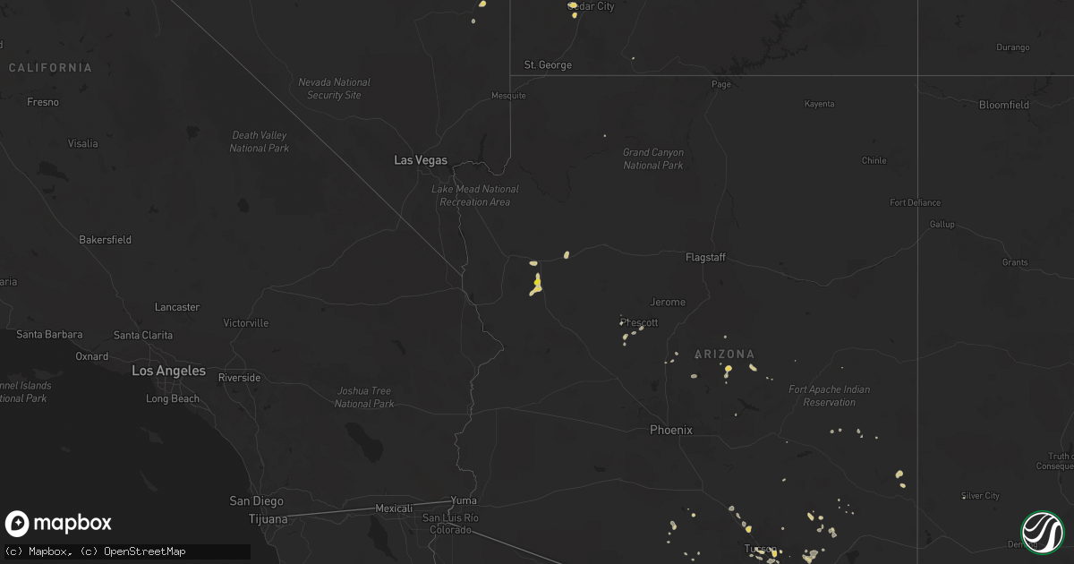
Hail Map on August 8, 2024
Get this storm
August 8 map
$229
one time, instant access
Download today. No call, no setup
Keep the $229
Bought the map and want the full workflow? Apply the entire $229 to a subscription within 7 days. None of it is wasted.
Every map, not just this one
This buys you this map. Subscription and you get every map we run, in the markets you choose from a few cities to whole states to nationwide. Plus real-time alerts the moment a storm fires.
Contact data
Name, contact info, occupancy, even credit band for addresses in the footprint. You go from where it hit to who to call.
Become the source they trust
Unlimited branding weather history reports on demand. You already have the documented answer ready for the property owner, and you are the one who showed up with it.
Property data and RoofTrace estimates
Pull up any address you have got, its value and the exact code rules for that jurisdiction, straight from One Click Code. Then RoofTrace estimates the squares, pitch, and roof value, priced the way you price.
States Impacted by Hail Map on August 8, 2024
Storm reports
Pennsylvania
| Date | Description |
|---|---|
| 08/08/20244:45 AM CDT | Multiple trees down... Some on a house. |
| 08/08/20243:33 AM CDT | Dozens of trees down; structural damage warehouse. |
Delaware
| Date | Description |
|---|---|
| 08/08/20246:12 PM CDT | Two independent reports from a trained spotter and fire department of a tornado on the ground near the intersection of route 7 and kirkwood highway near the kirkwood pl |
| 08/08/20246:11 PM CDT | Probable tornado- trees onto garage. Other large tree down nearby. |
| 08/08/20246:09 PM CDT | Probable tornado. Roof damage to grocery store. |
Arizona
| Date | Description |
|---|---|
| 08/08/20246:30 PM CDT | Power pole down near speedway and greasewood rd. |
| 08/08/20246:22 PM CDT | Mesquite tree down near kolb and 22nd. |
| 08/08/20246:14 PM CDT | Large palo verde tree down near broadway and wilmont. |
| 08/08/20246:10 PM CDT | Asos station at tucson international airport recorded a wind gusts of 70 mph. |
Virginia
| Date | Description |
|---|---|
| 08/08/20246:16 PM CDT | Tree down in the 30 block of blair road |
| 08/08/20246:05 PM CDT | Spotter reports multiple trees down on homes ese of bowling green. Possible tornado. |
| 08/08/20245:55 PM CDT | Corrected for time and additional information. Dispatch reports at least 10 homes that were damaged... With multiple trees downed... In the lake caroline subdivision an |
| 08/08/20245:50 PM CDT | Dispatch reports several homes damaged and multiple trees down in the lake caroline subdivision and on cedar fork rd. Possible tornado. |
| 08/08/20242:41 PM CDT | Large trees down on pruden blvd north of suffolk. Possible tornado based on radar data. |
| 08/08/20242:38 PM CDT | *** 2 inj *** corrects previous tstm wnd dmg report from 1 se kings fork. Large trees down on pruden blvd north of suffolk. 2 minor injuries and one tree down on a vehi |
| 08/08/20241:28 PM CDT | Large oak blown down. |
| 08/08/202410:10 AM CDT | The pittsylvania county 911 center reported that a large tree was down across tom fork road in the 3000 block of the roadway. The downed tree was blocking the entire ro |
| 08/08/202410:09 AM CDT | The smyth county 911 center reports that a tree was down across u.s. Highway 11 and the road was partially blocked as a result. |
| 08/08/20248:47 AM CDT | The city of roanoke reported that power lines were down in the 2700 block of mansfield street northeast. |
| 08/07/20248:19 PM CDT | Confirmed ef-1 tornado with 100 mph estimated peak winds. Estimated maximum path width was 100 yards. Estimated path length was 4.7 miles. |
| 08/07/20247:00 PM CDT | Several trees down along hartwood rd. Near park farm ln. Tornado preliminarily confirmed by dual-pol radar analysis... And will be followed up by a ground survey in the |
Georgia
| Date | Description |
|---|---|
| 08/08/20242:45 PM CDT | Tree limbs blocked the right lane of sr-122 eastbound at alderman road. |
West Virginia
| Date | Description |
|---|---|
| 08/07/202410:50 PM CDT | Confirmed ef-0 tornado with 80 mph estimated peak winds. Estimated maximum path width was 150 yards. Estimated path length was 0.3 miles |
| 08/07/202410:25 PM CDT | Berkeley county em reports power lines and trees downed near the 190th block of brumbaugh lane. Possible tornado. |
South Carolina
| Date | Description |
|---|---|
| 08/08/20246:23 PM CDT | Colleton county emergency management reported a tree down and power lines down blocking one lane near the intersection of wesley grove road and rehoboth road. |
| 08/08/20246:12 PM CDT | Colleton county emergency management reported a tree down on longleaf drive near jefferies highway. |
| 08/08/20243:25 AM CDT | Emegency manager reported a tree blocking the haynesville ext due to flood flashing and thunderstorm wind. |
| 08/07/20249:45 PM CDT | Colleton county emergency management reported a tree down near the intersection of round o road and sidneys road. The tree was blocking both lanes of the roadway. |
North Carolina
| Date | Description |
|---|---|
| 08/08/20246:44 PM CDT | Tree down near the intersection of weldon road and us-1. |
| 08/08/20246:01 PM CDT | Destroyed residence near nc highway 39 and henry ayscue rd. |
| 08/08/20246:01 PM CDT | Power lines down and possible structural damage near the epsom fire department... On nc highway 39 near eaves rd. |
| 08/08/20242:29 PM CDT | Debris... Power lines... And limbs down at the 1400 block of rocky ford road. |
| 08/08/20241:20 PM CDT | Reports of a few trees down on power lines and limbs down in the corapeake area. May have been a possible brief touchdown according to radar - time estimated from radar |
| 08/08/202410:00 AM CDT | Several roads blocked by fallen trees across davidson county including tussey rd... Kindley rd... Country ln... Tussey ave... Old burkhart rd... Midway school rd... And |
| 08/08/20249:51 AM CDT | The surry county sheriffs office reported that a tree was down blocking the roadway at the intersection of long hill road and ararat road in the area of pilot mountain. |
| 08/08/20249:30 AM CDT | Several reports of trees down blocking roads across chatham county including stone hill road... Old graham road... Sandy branch church road... And hadley mill road. |
| 08/08/20247:45 AM CDT | Sr-1006 |
| 08/08/20247:11 AM CDT | Damage to trees and homes near white level road and hickory rock road caused by tornado. |
Nevada
| Date | Description |
|---|---|
| 08/07/202411:25 PM CDT | Nevada dot sensor in moapa reported a gust of 59 mph. |
| 08/07/20248:38 PM CDT | Coils creek raws |
Cities Impacted by Hail Map on August 8, 2024
- Nashville, NC
- Louisburg, NC
- Corapeake, NC
- Suffolk, VA
- Stony Creek, VA
- Dinwiddie, VA
- McKenney, VA
- Dewitt, VA
- Church Road, VA
- Ford, VA
- Wilsons, VA
- Henderson, NC
- Kittrell, NC
- Willcox, AZ
- Patagonia, AZ
- Sonoita, AZ
- Nogales, AZ
- White Plains, GA
- Benson, AZ
- Tumacacori, AZ
- Vail, AZ
- Beryl, UT
- Young, AZ
- Kingman, AZ
- Pine, AZ
- Prescott, AZ
- Seligman, AZ
- Tubac, AZ
- Payson, AZ
- Kirkland, AZ
- Skull Valley, AZ
- Yarnell, AZ
- Orderville, UT
- Cedar City, UT
- Tucson, AZ
- Wilmington, DE
- Hockessin, DE
- San Simon, AZ
- Rodeo, NM
- Morenci, AZ
- Clifton, AZ
- San Jose, NM
- Fredericksburg, VA
- Stafford, VA
- Goldvein, VA
- Marana, AZ
- Pecos, NM
- Ashburn, GA
- Douglas, AZ
- Moriarty, NM
- Eloy, AZ
- Florence, AZ
- Upperville, VA
- Bluemont, VA
- Hale Center, TX
- Encino, NM
- Berryville, VA
- Plainview, TX
- Sells, AZ
- Seymour, TX
- Capitan, NM
- Crowell, TX
- Rocky Mount, NC
- Hedgesville, WV
- Harrisburg, PA