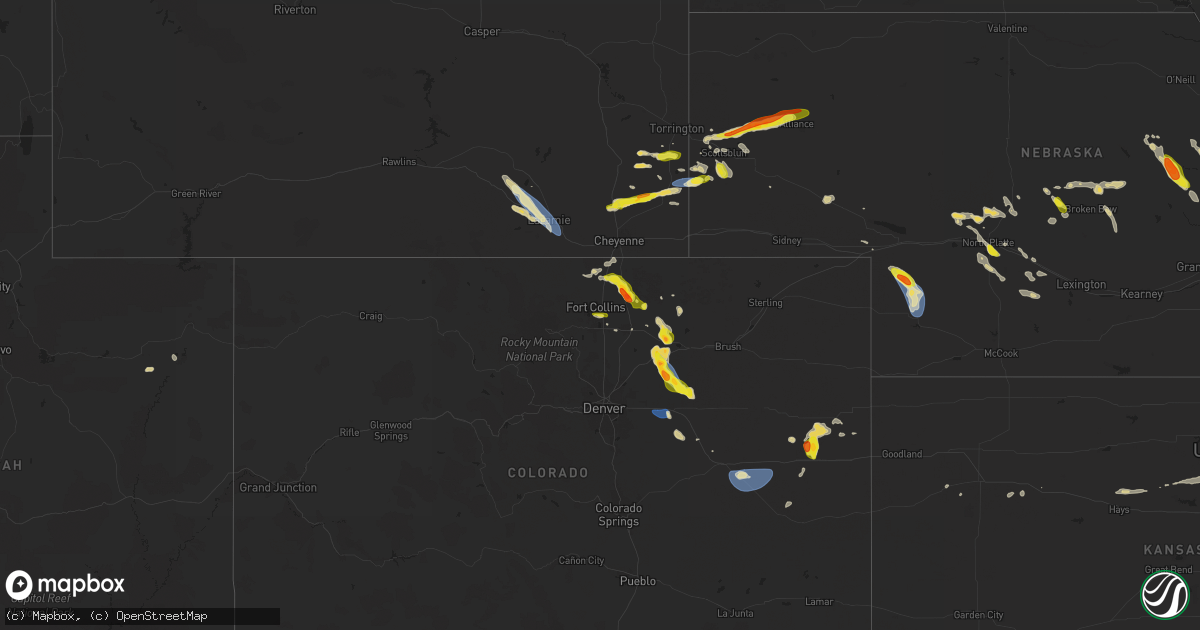
Hail Map on August 7, 2024
Get this storm
August 7 map
$229
one time, instant access
Download today. No call, no setup
Keep the $229
Bought the map and want the full workflow? Apply the entire $229 to a subscription within 7 days. None of it is wasted.
Every map, not just this one
This buys you this map. Subscription and you get every map we run, in the markets you choose from a few cities to whole states to nationwide. Plus real-time alerts the moment a storm fires.
Contact data
Name, contact info, occupancy, even credit band for addresses in the footprint. You go from where it hit to who to call.
Become the source they trust
Unlimited branding weather history reports on demand. You already have the documented answer ready for the property owner, and you are the one who showed up with it.
Property data and RoofTrace estimates
Pull up any address you have got, its value and the exact code rules for that jurisdiction, straight from One Click Code. Then RoofTrace estimates the squares, pitch, and roof value, priced the way you price.
States Impacted by Hail Map on August 7, 2024
Storm reports
Colorado
| Date | Description |
|---|---|
| 08/07/20246:05 PM CDT | A local report indicates 60 MPH wind near 2 WSW Leader |
| 08/07/20246:00 PM CDT | A local report indicates 60 MPH wind near 4 SW Strasburg |
| 08/07/20245:27 PM CDT | A local report indicates 58 MPH wind near 7 ESE Prospect Valley |
| 08/07/20244:33 PM CDT | Corrects previous non-tstm wnd gst report from 1 w masters. Mesonet station co222 dearfield. |
| 08/07/20243:25 PM CDT | A local report indicates 1.75 inch wind near Nunn |
| 08/07/20243:08 PM CDT | Corrects previous non-tstm wnd gst report from nunn. Mesonet station co171 nunn. |
| 08/07/20243:06 PM CDT | Corrects previous non-tstm wnd gst report from 5 nnw nunn. Mesonet station up718 4.9 n nunn |
| 08/06/20248:02 PM CDT | A local report indicates 68 MPH wind near 8 NNW Boyero |
| 08/06/20247:35 PM CDT | A local report indicates 63 MPH wind near 1 NNW Hugo |
| 08/06/20247:32 PM CDT | A local report indicates 58 MPH wind near 5 S Hugo |
North Carolina
| Date | Description |
|---|---|
| 08/07/20241:43 PM CDT | Debris on highway 53 from tornado |
| 08/07/20241:19 PM CDT | Confirmed tornado. At least one law enforcement eyewitness as it was on the ground... Plus confirmed by tds on krax. Two homes damaged. |
| 08/07/20246:41 AM CDT | 200 people without power on nc 43 just north of nc 55 caused by fallen trees on powerlines. |
| 08/07/20241:52 AM CDT | *** 1 fatal *** home collapsed resulting in 1 fatality on lloyd road. |
| 08/07/20241:52 AM CDT | Several homes damaged or destroyed along lloyd road between wiggins mill road and governor hunt road. |
| 08/07/20241:51 AM CDT | Extensive damage to springfield middle school. |
| 08/07/20241:15 AM CDT | Carteret-craven emc reported powerlines torn down along salter path road in pine knoll shores. Time based on radar. |
| 08/07/20241:10 AM CDT | Carteret-craven emc reported a tree top broken off that fell onto power lines in newport. |
| 08/07/20241:08 AM CDT | A tornado touched down at this location that would go on to create damage consistent with ef-1 and ef-2 wind speeds. Additional information available in the damage surv |
New Mexico
| Date | Description |
|---|---|
| 08/06/20247:50 PM CDT | Mesonet station nm004 lordsburg playa i10 mp12 |
Nebraska
| Date | Description |
|---|---|
| 08/07/20246:46 PM CDT | Storm chaser reports 1.0 in hail south of gering via the spotter network. |
| 08/07/20246:45 PM CDT | Recieved numerous photos of wind damage south of gering near the banner county line. Several trees were snapped with roof damage to a house. |
| 08/07/20246:18 PM CDT | Trained spotter measures quarter-size hail. |
| 08/06/202411:07 PM CDT | Asos station kiml imperial airport. |
| 08/06/202410:52 PM CDT | Comment from nerain observer 8nne scotia of some quarter size hail. Time est from radar. |
| 08/06/202410:51 PM CDT | Via ambient weather network. |
| 08/06/202410:27 PM CDT | Via ambient weather network. |
| 08/06/20248:59 PM CDT | A local report indicates 1.00 inch wind near 11 WSW Merna |
| 08/06/20247:05 PM CDT | Social media post measuring ping pong ball size hailstone. |
Kansas
| Date | Description |
|---|---|
| 08/07/202412:10 AM CDT | Mesonet station ks010 us-50 @ k-156 bridge garden city. |
| 08/07/202412:00 AM CDT | Asos station kgck garden city. |
| 08/06/202411:37 PM CDT | A local report indicates 66 MPH wind near 6 WNW Friend |
Wyoming
| Date | Description |
|---|---|
| 08/07/20245:52 PM CDT | Trained spotter measured 63 mph wind gust. |
| 08/07/20242:34 AM CDT | Asos station klar laramie airport - lar. |
| 08/07/20241:20 AM CDT | Delayed report of quarter sized hail 8 miles w of laramie along wy130. Time estimated based on radar. |
Arizona
| Date | Description |
|---|---|
| 08/06/20248:20 PM CDT | Heavy winds made heavy lawn furniture take flight. |
| 08/06/20247:40 PM CDT | Microburst. Thunderstorm wind gust measured at embry riddle aeronautical university. Power outages in area. |
| 08/06/20247:40 PM CDT | **corrected report** wet microburst. Thunderstorm wind measured at embry riddle aeronautical university. Power outages and trees down in the area. |
| 08/06/20247:06 PM CDT | Fb report. Golf ball sized hail in crown king. |
Cities Impacted by Hail Map on August 7, 2024
- Arenas Valley, NM
- Jupiter, FL
- Willard, NC
- Wellington, CO
- Sedona, AZ
- Harrells, NC
- Maple Hill, NC
- Carr, CO
- Sonoita, AZ
- Nunn, CO
- Pierce, CO
- Forest Lakes, AZ
- Ault, CO
- Fort Collins, CO
- Timnath, CO
- Vernal, UT
- Gill, CO
- Eaton, CO
- Galeton, CO
- Briggsdale, CO
- Buckhorn, NM
- Kersey, CO
- Orchard, CO
- Cheyenne, WY
- Windsor, CO
- Loveland, CO
- Roggen, CO
- Burnsville, WV
- Napier, WV
- Meriden, WY
- Heaters, WV
- Keenesburg, CO
- Hurricane, WV
- Willcox, AZ
- Pima, AZ
- Albin, WY
- Strasburg, CO
- Seibert, CO
- Vona, CO
- Culloden, WV
- Byers, CO
- Lagrange, WY
- Mitchell, NE
- Morrill, NE
- Harrisburg, NE
- Harrison, NE
- Scottsbluff, NE
- Lyman, NE
- Yoder, WY
- Stratton, CO
- Fort Lauderdale, FL
- Deer Trail, CO
- Minatare, NE
- Gering, NE
- Mayer, AZ
- Greeley, CO
- Alliance, NE
- Watkins, CO
- Bennett, CO
- Hawk Springs, WY
- San Carlos, AZ
- Peridot, AZ
- Crown King, AZ
- Torrington, WY
- Lisco, NE
- Agate, CO
- Bayard, NE
- Flagler, CO
- Payson, AZ
- Kirk, CO
- Hemingford, NE
- Hugo, CO
- Joes, CO
- Limon, CO
- Genoa, CO
- Arriba, CO
- Animas, NM
- Prescott, AZ
- Bethune, CO
- Burlington, CO
- North Platte, NE
- Hershey, NE
- Arnold, NE
- Stapleton, NE
- Green Valley, AZ
- Anselmo, NE
- Merna, NE
- Callaway, NE
- Elfrida, AZ
- Idalia, CO
- San Simon, AZ
- Benson, AZ
- Broken Bow, NE
- Douglas, AZ
- Ash Fork, AZ
- Big Springs, NE
- Maxwell, NE
- Brady, NE
- McNeal, AZ
- Brule, NE
- Wellfleet, NE
- Gothenburg, NE
- Burwell, NE
- Ericson, NE
- Grant, NE
- Ansley, NE
- Elgin, NE
- Petersburg, NE
- Comstock, NE
- Venango, NE
- Maywood, NE
- Bartlett, NE
- Sells, AZ
- Elgin, AZ
- Madrid, NE
- Imperial, NE
- Ord, NE
- Scotia, NE
- Greeley, NE
- Spalding, NE
- Sargent, NE
- Ewing, NE
- Cozad, NE
- Wauneta, NE
- Albion, NE
- Farnam, NE
- Moorefield, NE
- Enders, NE
- Eustis, NE
- Mason City, NE
- Monument, KS
- Wolbach, NE
- Saint Edward, NE
- Lindsay, NE
- Genoa, NE
- Monroe, NE
- Platte Center, NE
- Columbus, NE
- Silver Creek, NE
- Congress, AZ
- Grainfield, KS
- Gove, KS
- Osceola, NE
- Laramie, WY
- Park, KS
- Sutherland, NE
- Lewellen, NE
- Hays, KS
- Rock River, WY
- Victoria, KS
- Catharine, KS
- Gorham, KS
- Bosler, WY
- Luray, KS
- Lucas, KS
- Sylvan Grove, KS
- Waldo, KS
- Barnard, KS
- Ellsworth, KS
- Snow Hill, NC
- Stantonsburg, NC
- Wilson, KS
- Lucama, NC
- Kenly, NC
- Buford, WY
- Herington, KS
- Greenville, NC
- Macclesfield, NC
- Fountain, NC
- Pinetops, NC