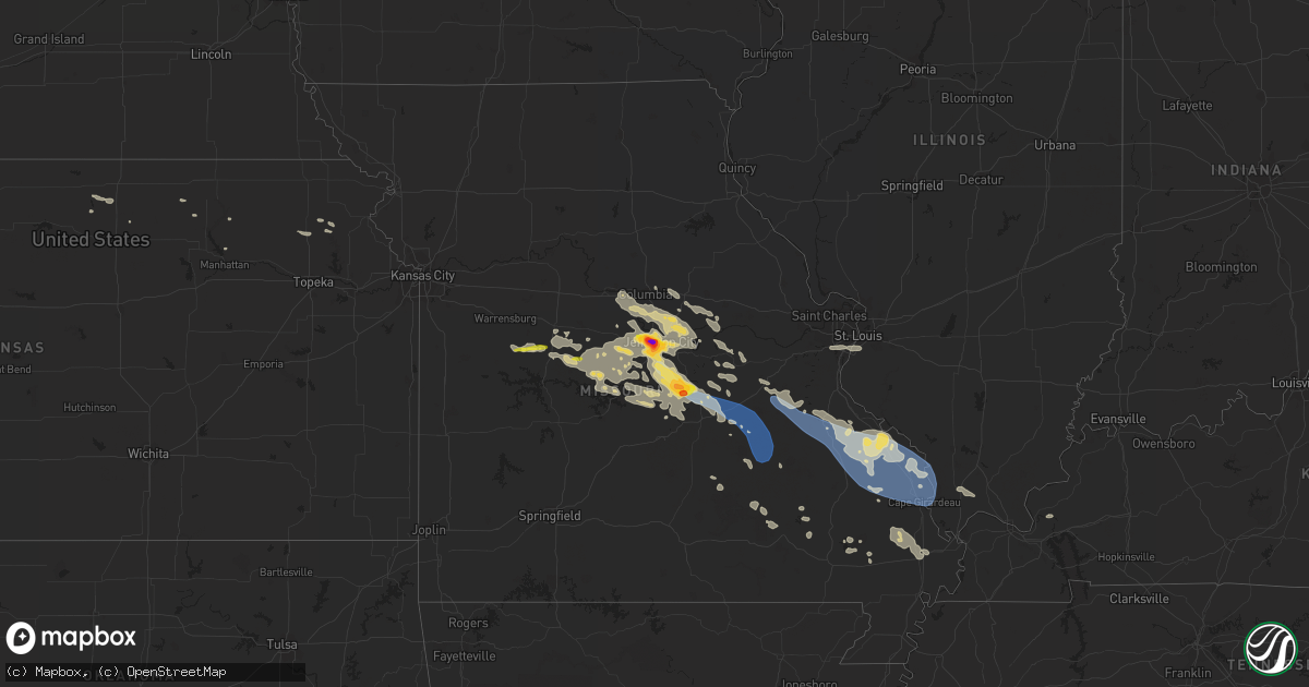
Hail Map on August 2, 2023
Get this storm
August 2 map
$229
one time, instant access
Download today. No call, no setup
Keep the $229
Bought the map and want the full workflow? Apply the entire $229 to a subscription within 7 days. None of it is wasted.
Every map, not just this one
This buys you this map. Subscription and you get every map we run, in the markets you choose from a few cities to whole states to nationwide. Plus real-time alerts the moment a storm fires.
Contact data
Name, contact info, occupancy, even credit band for addresses in the footprint. You go from where it hit to who to call.
Become the source they trust
Unlimited branding weather history reports on demand. You already have the documented answer ready for the property owner, and you are the one who showed up with it.
Property data and RoofTrace estimates
Pull up any address you have got, its value and the exact code rules for that jurisdiction, straight from One Click Code. Then RoofTrace estimates the squares, pitch, and roof value, priced the way you price.
States Impacted by Hail Map on August 2, 2023
Storm reports
Missouri
| Date | Description |
|---|---|
| 08/02/202310:41 AM CDT | Tree down on garage. Garage collapsed. Time estimated by radar. |
| 08/02/202310:39 AM CDT | Large trees down. Time estimated by radar. |
| 08/02/20235:15 AM CDT | Several trees down across highway 47. |
| 08/02/20234:06 AM CDT | Numerous tree limbs down on highway 303 northeast of linn as well as a roof of an old chicken house. Time estimated from radar. |
| 08/02/20233:34 AM CDT | Tree down on bob veach road. Time estimated from radar. |
| 08/02/20233:34 AM CDT | Large tree down on route y just east of ashland. Time estimated from radar. |
| 08/02/20233:33 AM CDT | A local report indicates 79 MPH wind near 3 NE Ashland |
| 08/02/20233:30 AM CDT | Water over roadways in and around new bloomfield... Including state highway j... And mm. State highway y had 6 inches of flowing water over it. |
| 08/02/20233:28 AM CDT | Tree down on highway mm near harold cunningham drive. |
| 08/02/20233:26 AM CDT | Multiple trees down on gleason road near state route n. |
| 08/02/20233:25 AM CDT | Tree down on old plank road near state route k. Time estimated from radar. |
| 08/02/20233:21 AM CDT | Tree down on stanley poe road. Time estimated from radar. |
| 08/02/20233:21 AM CDT | Multiple trees down along route n. Time estimated from radar. |
| 08/01/202311:55 PM CDT | Trees down with power outages in fruitland. Report relayed by kfvs 12. Time estimated from radar. |
| 08/01/202311:32 PM CDT | Power lines down near patton. Relayed by kfvs 12. Time estimated from radar. |
| 08/01/202311:30 PM CDT | Broadcast media relayed reports of downed trees and power outages in fredericktown. Time estimated from radar. |
| 08/01/202311:20 PM CDT | Trees down with power outages at lake perry. |
| 08/01/202311:06 PM CDT | The city of iberia there are reports of buildings with damage and tin roofing located in the neighboring feilds as well as the entire city of iberia is out of power. |
| 08/01/202310:58 PM CDT | Photos on twitter show trees down along highway d and in goose creek. Time estimated from radar. |
| 08/01/202310:55 PM CDT | Corrects previous tstm wnd dmg report from 1 e farmington. County dispatch and em relayed reports of numerous trees and power lines down... And a stop light pole was be |
| 08/01/202310:55 PM CDT | Photo on twitter shows a large tree down across a road in farmington. Time estimated from radar. |
| 08/01/202310:49 PM CDT | County dispatch reported several trees down in park hills. Time estimated from radar. |
| 08/01/202310:48 PM CDT | Corrects previous tstm wnd dmg report from 3 w howes. 4 miles nnw of salem. Large tree limb snapped. |
| 08/01/202310:48 PM CDT | Widespread tree damage north of farmington. Time estimated from radar. Facebook report. |
| 08/01/202310:46 PM CDT | Corrects previous tstm wnd gst report from desloge. Spotter measured 72 mph gust from a personal weather station. |
| 08/01/202310:45 PM CDT | County dispatch reports numerous trees down in bonne terre. Time estimated from radar. |
| 08/01/202310:42 PM CDT | Large tree down on a home at main and cross street. |
| 08/01/202310:38 PM CDT | Several trees down in terre du lac... With reports of trees on houses. Time estimated from radar. |
| 08/01/202310:30 PM CDT | Large tree down. Facebook report. Time estimated from radar. |
| 08/01/202310:24 PM CDT | Multiple trees and power lines down in potosi. |
| 08/01/202310:12 PM CDT | A local report indicates 1.00 inch wind near 2 NE Laurie |
| 08/01/20239:58 PM CDT | Several trees down over roadways in cuba. |
| 08/01/20239:32 PM CDT | Numerous power poles down. Time based on radar. |
| 08/01/20239:31 PM CDT | A local report indicates 1.75 inch wind near Vienna |
| 08/01/20239:20 PM CDT | Power outages in area. |
| 08/01/20238:57 PM CDT | A local report indicates 1.00 inch wind near 1 SW Stover |
| 08/01/20238:46 PM CDT | County dispatch reported trees down across highway 133. Time estimated from radar. |
| 08/01/20238:20 PM CDT | County dispatch received reports of trees down across tanner bridge road and route b. Time estimated from radar. |
| 08/01/20238:04 PM CDT | A local report indicates 1.75 inch wind near 2 WNW Jefferson City |
| 08/01/20238:04 PM CDT | Several golf ball size stones and many quarter size stones. |
| 08/01/20238:00 PM CDT | A local report indicates 1.00 inch wind near 4 ESE Saint Martins |
| 08/01/20237:56 PM CDT | Delayed report. Photos on facebook show several 2 inch hail stones... With some 2.5 inches in diameter on the west side of jefferson city. Time estimated from radar. |
| 08/01/20237:55 PM CDT | A local report indicates 1.00 inch wind near 1 SE Jefferson City |
| 08/01/20237:51 PM CDT | Reported via social media. |
Colorado
| Date | Description |
|---|---|
| 08/01/202310:57 PM CDT | Mesonet station co101 082w023 basalt-holland hills. |
| 08/01/202310:57 PM CDT | Corrects previous tstm wnd gst report from 1 s basalt. Mesonet station co101 082w023 basalt-holland hills. Gust is too strong compared to neighboring observations. Disc |
| 08/01/202310:48 PM CDT | Mesonet station cmec2 cottonwood basin. |
| 08/01/20239:23 PM CDT | Mesonet station pirc2 pinto... Massadona 18se. |
| 08/01/20239:13 PM CDT | A local report indicates 67 MPH wind near 2 SSE Peterson AFB |
| 08/01/20239:07 PM CDT | A local report indicates 62 MPH wind near 2 SSE Peterson AFB |
| 08/01/20238:50 PM CDT | A local report indicates 60 MPH wind near 3 W Fountain |
| 08/01/20237:44 PM CDT | Asos station kcez cortez municipal airport. |
Utah
| Date | Description |
|---|---|
| 08/02/20236:06 PM CDT | Asos station kcny 16 nw moab. |
| 08/02/20235:20 PM CDT | Mesonet station ut201 sr-201 at i-80. |
| 08/02/20235:15 PM CDT | Mesonet station kcc01 6.0 ne lake pt |
| 08/02/20235:00 PM CDT | Two 2-inch tree branches downed from an otherwise healthy tree. |
| 08/02/20235:00 PM CDT | Mesonet station pc022 mount aire canyon. |
| 08/02/20234:43 PM CDT | A local report indicates 1.00 inch wind near Herriman |
| 08/02/20234:38 PM CDT | A tree fell and landed on a car. |
| 08/02/20234:30 PM CDT | Mesonet station utrvt sr-154 at mp 7 riverton. |
| 08/02/20234:20 PM CDT | Mesonet station utchl us-189 at charleston. |
| 08/02/20234:10 PM CDT | Mesonet station pc034 provo canyon. |
| 08/02/20234:00 PM CDT | Mesonet station snd arrowhead summit. |
| 08/02/20234:00 PM CDT | A carport partially collapsed at an apartment complex. |
| 08/02/20233:47 PM CDT | Awos station kpvu provo municipal airport. |
| 08/02/20233:45 PM CDT | Mesonet station vrh vernon hill. |
| 08/02/20233:40 PM CDT | Mesonet station utbrc i-15 at beer creek. |
| 08/02/20233:30 PM CDT | Mesonet station fg024 west mountain south. |
| 08/02/20233:20 PM CDT | Mesonet station utrky rocky ridge. |
| 08/02/20233:10 PM CDT | Mesonet station pc349 nephi west. |
| 08/02/20232:51 PM CDT | Mesonet station sbwu1 sevier reservoir. |
| 08/02/20232:20 PM CDT | Mesonet station ut26 i-15 at sevier river nb. |
| 08/02/20231:52 PM CDT | Mesonet station up137 3.7 se hinckley. |
Michigan
| Date | Description |
|---|---|
| 08/02/20232:05 PM CDT | Report from mping: 1-inch tree limbs broken; estimated wind gusts of 50 to 60 mph. |
| 08/02/20231:40 PM CDT | Report called in regarding some trees down on m35 just north of cedar river. |
Nebraska
| Date | Description |
|---|---|
| 08/02/20236:58 PM CDT | A local report indicates 61 MPH wind near Crescent Lake Nwr |
| 08/02/20236:55 AM CDT | Emergency management reported tree damage near the intersection of 729 road and s lincoln street. Time estimated from radar and nearby mesonet gusts. |
| 08/02/20236:55 AM CDT | Emergency management reported tree dama |
| 08/02/20236:54 AM CDT | A local report indicates 78 MPH wind near 3 SSW Holdrege |
| 08/02/20236:54 AM CDT | Emergency management reported a couple pivots overturned... Tree and grain bin damage near the intersection of 730 road and m road. Nearby mesonet gusted to 78 mph. Tim |
| 08/02/20236:54 AM CDT | Emergency management reported a couple pivots overturned... Tree |
| 08/02/20236:54 AM CDT | A local report indicates 60 MPH wind near 3 S Holdrege |
| 08/02/20236:50 AM CDT | Emergency management reported a grain bin was blown across the road from a farmstead located near hwy 6 and k rd. A nearby mesonet gusted to 78 mph. Time estimated from |
| 08/02/20236:29 AM CDT | Social media photo of flipped irrigation pivot relayed by ntv. Time estimated from radar data. |
New Mexico
| Date | Description |
|---|---|
| 08/01/20238:35 PM CDT | Two utility poles were damaged in navajo dam from strong winds. This was likely caused by a dry microburst ahead of storms moving in from the west. |
| 08/01/20238:28 PM CDT | Corrects previous non-tstm wnd gst report from 3 w farmington. Asos station kfmn farmington airport. |
| 08/01/20238:25 PM CDT | Greenhouse damage from a strong gust front ahead of a line of storms moving east from arizona. |
| 08/01/20238:25 PM CDT | Several trees down in kiwanis park from a likely microburst. Individual heard a huge crack when trees fell. The microburst also came with a wall of sand and a possible |
| 08/01/20238:18 PM CDT | Down utility pole from a likely strong gust front ahead of line of storms moving east from arizona. |
Wisconsin
| Date | Description |
|---|---|
| 08/01/20237:42 PM CDT | One tree down on church rd... Just west of rosebud rd. Time estimated by radar. |
Cities Impacted by Hail Map on August 2, 2023
- Colorado City, AZ
- Vulcan, MI
- Fillmore, UT
- Delta, UT
- Lynndyl, UT
- Holden, UT
- Oak City, UT
- Nephi, UT
- Leamington, UT
- Eureka, UT
- Mona, UT
- Cedar Valley, UT
- Payson, UT
- Goshen, UT
- Salem, UT
- Santaquin, UT
- Spanish Fork, UT
- Eagle Mountain, UT
- Orem, UT
- Vineyard, UT
- Provo, UT
- Saratoga Springs, UT
- Riverton, UT
- Lehi, UT
- American Fork, UT
- Draper, UT
- Lindon, UT
- Alpine, UT
- Pleasant Grove, UT
- Springville, UT
- Sandy, UT
- Herriman, UT
- South Jordan, UT
- West Jordan, UT
- Salt Lake City, UT
- Midvale, UT
- Wallsburg, UT
- Heber City, UT
- Midway, UT
- Magna, UT
- West Valley City, UT
- Stockton, UT
- Sedgwick, CO
- Crook, CO
- Hermosa, SD
- Stephenson, MI
- Rock, MI
- Oelrichs, SD
- Chadron, NE
- Grand Canyon, AZ
- Wilson, MI
- Powers, MI
- Spalding, MI
- Nadeau, MI
- Hermansville, MI
- Carney, MI
- Tuba City, AZ
- Padroni, CO
- Sugartown, LA
- Peetz, CO
- Flagstaff, AZ
- Daggett, MI
- Sterling, CO
- Mittie, LA
- Dry Creek, LA
- Lodgepole, NE
- Williams, AZ
- Rapid River, MI
- Menominee, MI
- New Raymer, CO
- Fleming, CO
- Kingman, AZ
- Kanab, UT
- Hackberry, AZ
- Addis, LA
- Baton Rouge, LA
- Mulberry, FL
- Edgemont, SD
- Bowling Green, FL
- Lusk, WY
- Wauchula, FL
- Ona, FL
- Valentine, AZ
- Hammond, LA
- Perkins, MI
- Skandia, MI
- Jackson, LA
- Roosevelt, UT
- Duchesne, UT
- Iliff, CO
- Oshkosh, NE
- Lisco, NE
- Ellsworth, NE
- Lakeside, NE
- Jefferson City, MO
- Calhoun, MO
- Windsor, MO
- Green Ridge, MO
- Ionia, MO
- Saint Thomas, MO
- Meta, MO
- Westphalia, MO
- Argyle, MO
- Koeltztown, MO
- Vienna, MO
- Saint Elizabeth, MO
- Colorado Springs, CO
- Fountain, CO
- Belle, MO
- Vichy, MO
- Saint James, MO
- Cuba, MO
- Leasburg, MO
- Stover, MO
- Versailles, MO
- Peyton, CO
- Calhan, CO
- Steelville, MO
- Potosi, MO
- Bourbon, MO
- Cadet, MO
- Bismarck, MO
- Belgrade, MO
- Mineral Point, MO
- Irondale, MO
- Bonne Terre, MO
- Park Hills, MO
- Leadwood, MO
- Black, MO
- Davisville, MO
- Doe Run, MO
- Wesco, MO
- Ironton, MO
- Viburnum, MO
- Salem, MO
- Boss, MO
- Cook Sta, MO
- Caledonia, MO
- Belleview, MO
- Bixby, MO
- Cherryville, MO
- Sullivan, MO
- Richwoods, MO
- Farmington, MO
- Sainte Genevieve, MO
- Saint Mary, MO
- Fredericktown, MO
- Perryville, MO
- Winslow, AZ
- Marsland, NE
- Harrisburg, NE
- Tooele, UT
- Haxtun, CO
- Wausaukee, WI
- Gravois Mills, MO
- Barnett, MO
- Saint Francis, KS
- Wallace, MI
- Ingalls, MI
- Sturgeon Bay, WI
- Otis, CO
- Forestville, WI
- Brussels, WI
- Algoma, WI
- Plaquemine, LA
- Wamsutter, WY
- Yuma, CO
- Eckley, CO
- Wray, CO
- Porterfield, WI
- Marinette, WI
- Crivitz, WI
- Peshtigo, WI
- Centertown, MO
- Lohman, MO
- De Soto, MO
- Second Mesa, AZ
- Polacca, AZ
- Kykotsmovi Village, AZ
- Kanorado, KS
- Harrison, NE
- Deridder, LA
- Bland, MO
- Hardesty, OK
- Chambers, AZ
- Kit Carson, CO
- Cheyenne Wells, CO
- Arapahoe, CO
- Lincoln, MO
- Leeton, MO
- Potter, NE
- California, MO
- Eugene, MO
- Holts Summit, MO
- Russellville, MO
- Sedalia, MO
- French Village, MO
- Tuscumbia, MO
- Eldon, MO
- Goodland, KS
- Latham, MO
- Olean, MO
- Dixon, MO
- Rolla, MO
- Holbrook, AZ
- Cole Camp, MO
- Rocky Mount, MO
- Fortuna, MO
- Egg Harbor, WI
- Burkeville, TX
- Brumley, MO
- Iberia, MO
- Ulman, MO
- Baileys Harbor, WI
- Freeburg, MO
- Fish Creek, WI
- Lake Ozark, MO
- Sunrise Beach, MO
- Mullen, NE
- Jamestown, MO
- Henley, MO
- Smithton, MO
- Mora, MO
- Blackwell, MO
- Frohna, MO
- Sedgewickville, MO
- Patton, MO
- Farrar, MO
- Uniontown, MO
- Altenburg, MO
- Marble Hill, MO
- Old Appleton, MO
- Whitewater, MO
- Daisy, MO
- Burfordville, MO
- Jackson, MO
- Scott City, MO
- Cape Girardeau, MO
- Friedheim, MO
- Chaffee, MO
- Marquand, MO
- Oak Ridge, MO
- Millersville, MO
- Oran, MO
- Leopold, MO
- McClure, IL
- Grand Tower, IL
- Wolf Lake, IL
- Jonesboro, IL
- Sutherland, NE
- Burlington, CO
- Piedmont, MO
- Ellington, MO
- Jamestown, KS
- Agate, CO
- Ramah, CO
- Osage Beach, MO
- Concordia, KS
- Genoa, CO
- Limon, CO
- Wappapello, MO
- Broomfield, CO
- Longmont, CO
- Erie, CO
- New Bloomfield, MO
- McGee, MO
- Holton, KS
- Effingham, KS
- Muscotah, KS
- Valley Falls, KS
- Ashland, MO
- Bonnots Mill, MO
- Linn, MO
- Courtland, KS
- Norway, KS
- Scandia, KS
- Puxico, MO
- Dudley, MO
- Dexter, MO
- Bloomfield, MO
- Stapleton, NE
- North Platte, NE
- Chamois, MO
- Dupo, IL
- East Carondelet, IL
- Tebbetts, MO
- Mokane, MO
- Winona, MO
- Poplar Bluff, MO
- Owensville, MO
- Rosebud, MO
- Fulton, MO
- Manhattan, KS
- Columbia, MO
- Valles Mines, MO
- Hartsburg, MO
- Maxwell, NE
- Brady, NE
- Florence, MO
- Rhineland, MO
- Portland, MO
- Brinktown, MO
- Barnes, KS
- Randolph, KS
- Greenleaf, KS
- Westmoreland, KS
- Vienna, IL
- Cypress, IL
- Dongola, IL
- Anna, IL
- Bethune, CO
- Green Bay, WI
- Jadwin, MO
- Mill Spring, MO
- Whiting, KS
- Newburg, MO
- Crocker, MO
- Tipton, MO
- Kaiser, MO
- Bunker, MO
- Boonville, MO
- Clarksburg, MO
- Saint Louis, MO
- Columbia, IL
- Fenton, MO
- Syracuse, MO
- Holdrege, NE
- Atlanta, NE
- Alma, NE
- Republican City, NE
- Naponee, NE
- Wilcox, NE
- Hildreth, NE
- Bloomington, NE
- Hershey, NE
- Advance, MO
- Bell City, MO
- Kingdom City, MO
- Auxvasse, MO
- McDonald, KS
- Loomis, NE
- Sikeston, MO
- Vanduser, MO
- Bertrand, MO
- Bertrand, NE
- Hermann, MO
- Morrison, MO
- Lemoyne, NE
- Wooldridge, MO
- Gerald, MO
- Athol, KS
- Kensington, KS
- Smith Center, KS
- Kirwin, KS
- Tiline, KY
- Salem, KY
- Steedman, MO
- Williamsburg, MO
- Prairie Home, MO
- Rocheport, MO
- Rush Valley, UT
- Oxford, NE