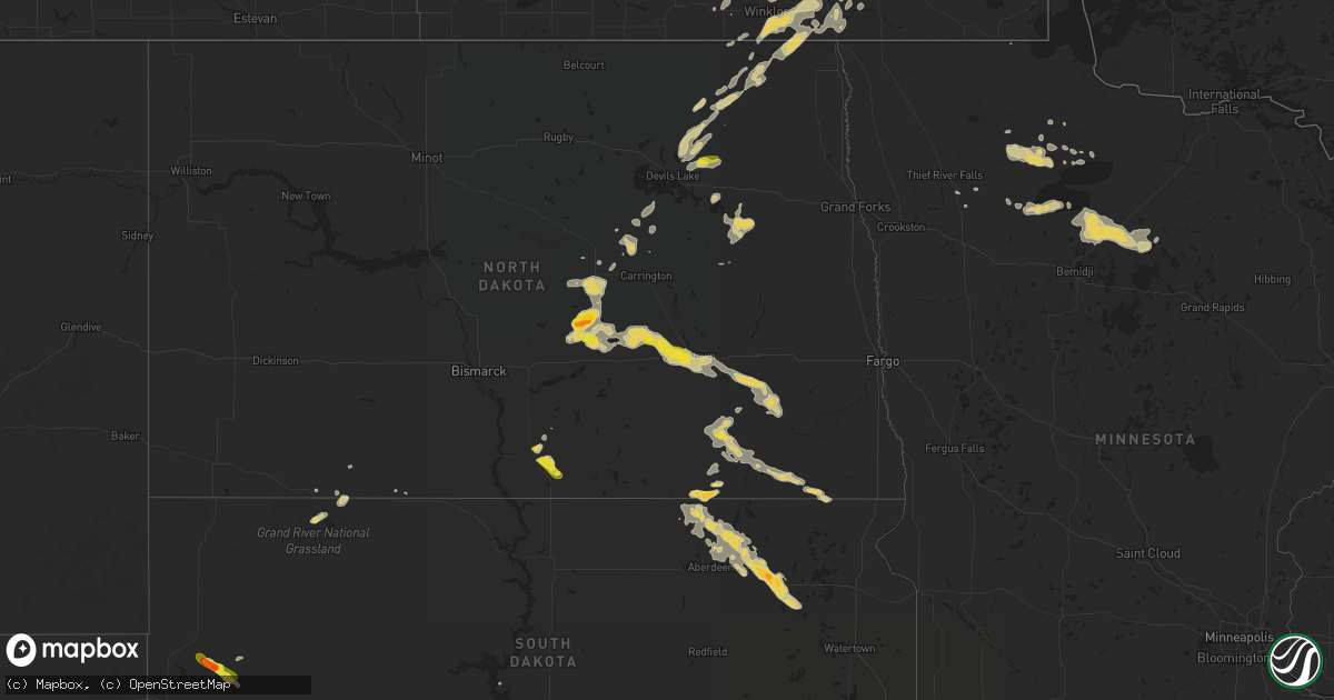
Hail Map on August 1, 2016
Get this storm
August 1 map
$229
one time, instant access
Download today. No call, no setup
Keep the $229
Bought the map and want the full workflow? Apply the entire $229 to a subscription within 7 days. None of it is wasted.
Every map, not just this one
This buys you this map. Subscription and you get every map we run, in the markets you choose from a few cities to whole states to nationwide. Plus real-time alerts the moment a storm fires.
Contact data
Name, contact info, occupancy, even credit band for addresses in the footprint. You go from where it hit to who to call.
Become the source they trust
Unlimited branding weather history reports on demand. You already have the documented answer ready for the property owner, and you are the one who showed up with it.
Property data and RoofTrace estimates
Pull up any address you have got, its value and the exact code rules for that jurisdiction, straight from One Click Code. Then RoofTrace estimates the squares, pitch, and roof value, priced the way you price.
States Impacted by Hail Map on August 1, 2016
Storm reports
Kentucky
| Date | Description |
|---|---|
| 08/01/20166:00 PM CDT | Wind damage to roof of walmart. Also 3000 customers were without power as a power pole was snapped due to high winds. |
| 08/01/20162:39 PM CDT | Several trees down. One tree fell on and damaged part of a church. |
| 08/01/20162:16 PM CDT | Delayed report. Several trees down on west side of maxon road between cairo and harris road...north of railroad tracks. Damage to one home. Time of damage estimated fro |
Florida
| Date | Description |
|---|---|
| 08/01/20165:40 PM CDT | Spotter reported oak tree 12 inches in diameter fell on car. Time estimated based on radar. |
| 08/01/20164:40 PM CDT | Public report received of quarter-sized hail in oceanway. Timing estimated by radar. |
| 08/01/201612:35 PM CDT | Local electric company reported a tree down. |
South Carolina
| Date | Description |
|---|---|
| 08/01/20166:36 PM CDT | Tree in roadway frank shealy rd and rebecca drive. |
| 07/31/20168:05 PM CDT | Tree down wattling rd. Time estmd by radar. |
| 07/31/20168:05 PM CDT | Tree in roadway. |
| 07/31/20167:50 PM CDT | Report of multiple trees down on spears creek church rd. |
| 07/31/20167:46 PM CDT | Large tree down on wildcat rd blocking one lane of traffic. Picture received via social media and time estimated based on radar. |
| 07/31/20167:46 PM CDT | Tree down on house... Arcadia woods drive. |
| 07/31/20167:17 PM CDT | Tree in roadway poplar springs rd and bass pond rd. |
| 07/31/20167:05 PM CDT | Multiple trees down wheeland and bens peninsula rds. |
| 07/31/20167:05 PM CDT | Trees in roadway hope ferry rd and corley mill rd. |
Georgia
| Date | Description |
|---|---|
| 08/01/20163:18 PM CDT | Broadcast media received report of a large tree limb downed on powerlines off of slash pine road. Timing estimated by radar. |
| 07/31/20169:15 PM CDT | Tree down off epperson rd. 1018pm...wires down along creek hollow dr. |
| 07/31/20169:13 PM CDT | Tree and wires down at gaddis rd and arbor hill rd. |
| 07/31/20167:07 PM CDT | Tree downed along lemans street |
| 07/31/20167:06 PM CDT | A tree and wires are down on field ford road. |
| 07/31/20167:06 PM CDT | Tree down on a house on bethel road. Wires down in the area as well. |
| 07/31/20167:04 PM CDT | Tree downed along barberry hill drive |
| 07/31/20167:01 PM CDT | Several trees down in the kingston area. |
North Dakota
| Date | Description |
|---|---|
| 08/01/20166:35 PM CDT | A local report indicates 1.00 inch wind near 1 SSE JAMESTOWN |
| 08/01/20166:24 PM CDT | Dime size hail also reported with the wind. Other public report indicated pea size hail and getting larger. |
| 08/01/20165:22 PM CDT | Dime to quarter sized hail and very heavy rain. |
| 08/01/20164:27 PM CDT | Hail ongoing last 5 minutes. |
| 08/01/20164:25 PM CDT | Golf ball size hail fell near robinson. |
| 08/01/20164:03 PM CDT | Mostly sub-severe hail... A few larger stones size of a quarter. |
| 08/01/20163:53 PM CDT | A patch of dime to quarter sized hail and very heavy rains moved across the county line from well county into southwest rosefield township. |
| 07/31/20168:58 PM CDT | Time estimated by radar. |
| 07/31/20167:32 PM CDT | Mostly penny size hail... Largest up to the size of a quarter. |
| 07/31/20167:15 PM CDT | Large hail with very strong winds. Some 3 to 4 inch diameter tree branches broken down in southern scandia township. |
Maryland
| Date | Description |
|---|---|
| 08/01/20164:46 PM CDT | Large tree down onto road near intersection of queen anne bridge rd and w central ave |
| 08/01/20164:28 PM CDT | Tree fell on a house |
| 08/01/20164:22 PM CDT | Pea to dime size hail |
| 08/01/20164:16 PM CDT | Large tree down near intersection of shore acres rd and bennett rd |
| 08/01/20163:42 PM CDT | Structural damage to restaurant and adjacent roadway. Large equipment storage bin overturned and displaced down the beach. Storm survey is ongoing... And further detail |
| 08/01/20163:42 PM CDT | . |
| 08/01/20163:40 PM CDT | . |
| 08/01/20163:40 PM CDT | Storm survey concluded damage consistent with an ef0 tornado. Minor structural damage to restaurant and adjacent roadway |
| 08/01/20163:38 PM CDT | 53 kt at ocean city buoy. |
Utah
| Date | Description |
|---|---|
| 07/31/20169:15 PM CDT | St george airport awos... Ksgu. |
Texas
| Date | Description |
|---|---|
| 08/01/20164:35 PM CDT | A local report indicates 62 MPH wind near 2 NNW ALPINE |
Pennsylvania
| Date | Description |
|---|---|
| 08/01/20165:45 PM CDT | Trees/wires down |
| 08/01/20165:40 PM CDT | Trees down onto house on main street. |
| 08/01/20163:36 PM CDT | Trees down |
| 08/01/20163:20 PM CDT | Trees down |
| 08/01/20161:14 PM CDT | 1.25 inches of rain with 52mph wind gust and quarter size hail |
Iowa
| Date | Description |
|---|---|
| 08/01/20167:27 AM CDT | Numerous trees with diameter upwards of one foot down around lake view. Tree reported downed onto truck. Time and location estimated from radar. |
| 08/01/20167:20 AM CDT | Report of several trees up to one foot in diameter down near schaller. Report via social media. Time and location estimated from radar. |
Tennessee
| Date | Description |
|---|---|
| 08/01/20166:06 PM CDT | Report of a tree down on highway 48 north. |
| 08/01/20165:54 PM CDT | Numerous reports of trees down on church road. |
| 08/01/20165:48 PM CDT | Numerous reports of trees down in the vacinity of pucket hollow road. |
| 08/01/20165:48 PM CDT | Numerous trees down reported in bon aqua. |
| 08/01/20164:54 PM CDT | Trees down in south waverly |
| 08/01/20164:46 PM CDT | Multiple trees down on flatwoods road in benton county. |
| 08/01/20164:45 PM CDT | Tree down on a power line on reese road. |
| 08/01/20164:42 PM CDT | Trees down between waverly an mcewen. |
| 08/01/20164:40 PM CDT | Tree down on marlboro rd 1 mile e of barren springs road causing power outage. |
| 08/01/20164:36 PM CDT | Received a couple of reports of trees down on old highway 13 and across the river on ham road. |
| 07/31/20167:16 PM CDT | Multiple trees down on cason lane along with numerous large branches down as well. A shed was flipped and destroyed at lowes. |
Nebraska
| Date | Description |
|---|---|
| 08/01/20166:36 PM CDT | Mostly quarter sized hail with a few half dollars mixed in. Heavy rain with winds gusting 35 to 45mph. Ponding on roads from heavy rain. |
| 08/01/20166:22 PM CDT | Est winds gusts to 55 to 60mph. Quarter sized hail with heavy rain. Water over some county roads west of town. |
| 08/01/20165:15 PM CDT | A local report indicates 1.00 inch wind near GANDY |
| 08/01/20162:25 AM CDT | 2.05 inches of rain as well. Some tree damage |
| 07/31/20167:45 PM CDT | Quarter sized hail with a few golf balls mixed in. Heavy rain. Roads also covered in hail south side of town. Some roads in town also reported to have flooding issues. |
| 07/31/20167:28 PM CDT | 7s of cambridge along hwy 47 golf ball sized hail falling. |
South Dakota
| Date | Description |
|---|---|
| 08/01/20164:55 PM CDT | A local report indicates 1.00 inch wind near 3 NW NEMO |
| 08/01/20164:20 PM CDT | A local report indicates 2.50 inch wind near 8 SSW BROWNSVILLE |
| 08/01/20164:01 PM CDT | A local report indicates 2.00 inch wind near 3 N MYSTIC |
| 08/01/20163:30 PM CDT | A local report indicates 1.00 inch wind near 8 WSW HILL CITY |
| 08/01/201612:08 AM CDT | Large tree limbs downed. Damage to crops. |
| 07/31/201611:42 PM CDT | Lost the roof off a building and the house. An outbuilding was also destroyed. . |
| 07/31/201611:42 PM CDT | A trailer was flipped. . |
| 07/31/201611:40 PM CDT | A 60 by 80 foot shed was destroyed. . |
| 07/31/201611:40 PM CDT | Numerous trees downed along with some power poles in andover. Damage to vehicles and buildings from large hail and winds along with crop damage. Hail piled up to 1 foot |
| 07/31/201611:40 PM CDT | Trees down in andover. |
| 07/31/201611:40 PM CDT | . |
| 07/31/201611:05 PM CDT | Quarter size hail and torrential rain. |
| 07/31/201611:03 PM CDT | . |
| 07/31/201611:03 PM CDT | . |
| 07/31/201610:15 PM CDT | Estimated 60-70 mph. |
| 07/31/20169:15 PM CDT | . |
| 07/31/20168:00 PM CDT | A local report indicates 1.00 inch wind near 5 ENE NEWELL |
| 07/31/20167:55 PM CDT | A local report indicates 1.75 inch wind near 5 NNE NEWELL |
North Carolina
| Date | Description |
|---|---|
| 08/01/20164:35 PM CDT | One tree partially blocking the road at intersection of old henrietta road and byers road. |
Cities Impacted by Hail Map on August 1, 2016
- Langdon, ND
- Denison, IA
- Vail, IA
- Cathay, ND
- Havana, ND
- Symsonia, KY
- Boaz, KY
- Scotia, NE
- Elba, NE
- North Loup, NE
- Ashby, NE
- Regina, NM
- Diller, NE
- Keystone Heights, FL
- Flowery Branch, GA
- Oakwood, GA
- Hickory, KY
- Mayfield, KY
- Hill City, SD
- Cleveland, ND
- Pingree, ND
- Jamestown, ND
- Woodworth, ND
- Ypsilanti, ND
- Medina, ND
- Buchanan, ND
- Nelson, NE
- Robinson, ND
- Rapid City, SD
- Nemo, SD
- Lead, SD
- Deadwood, SD
- Andover, SD
- Groton, SD
- Ocean City, MD
- Berlin, MD
- Cherokee, IA
- Aurelia, IA
- Tappen, ND
- Stapleton, NE
- Townsend, DE
- Frankford, DE
- Selbyville, DE
- Fort Valley, GA
- Perry, GA
- Cedar Rapids, NE
- Belgrade, NE
- Kathryn, ND
- Lisbon, ND
- Fort Ransom, ND
- Litchville, ND
- Nome, ND
- Georgiana, AL
- McKenzie, AL
- Beatrice, AL
- Pine Apple, AL
- Evergreen, AL
- Ellendale, ND
- Frederick, SD
- Pettibone, ND
- Wolbach, NE
- Ashton, NE
- Clearbrook, MN
- Gibson Island, MD
- Annapolis, MD
- Michigan, ND
- Lakota, ND
- Pekin, ND
- Mcville, ND
- Millsboro, DE
- Dagsboro, DE
- Georgetown, DE
- Bishopville, MD
- Delco, NC
- Beulaville, NC
- Blackduck, MN
- Squaw Lake, MN
- Moorefield, NE
- Milford, NE
- La Grange, NC
- Hines, MN
- Tenstrike, MN
- Dawson, ND
- Leakesville, MS
- Ericson, NE
- Burwell, NE
- Tilden, NE
- Neligh, NE
- Oakdale, NE
- Eustis, NE
- Sterrett, AL
- Montoursville, PA
- Alsen, ND
- Benton, KY
- Batesburg, SC
- Willard, NC
- Harrells, NC
- Genoa, NE
- Columbus, NE
- Crary, ND
- Paris, MO
- Madison, MO
- Holliday, MO
- Clarence, MO
- Excello, MO
- Greeley, NE
- Spalding, NE
- Cambridge, NE
- Indianola, NE
- Danbury, NE
- Bartley, NE
- Lebanon, NE
- Wilsonville, NE
- Edmore, ND
- Columbia, SD
- Houghton, SD
- Clearwater, NE
- Balko, OK
- Mexico, MO
- Beloit, KS
- Baton Rouge, LA
- Bowdon, ND
- Opelika, AL
- Walhalla, ND
- Cavalier, ND
- Neche, ND
- Ewing, NE
- Bethel, PA
- Womelsdorf, PA
- Bernville, PA
- Rehrersburg, PA
- Society Hill, SC
- Hartsville, SC
- Leonard, MO
- Novelty, MO
- Schuyler, NE
- Talladega, AL
- Petersburg, NE
- Hooker, OK
- Guymon, OK
- Leesville, SC
- Grygla, MN
- Westport, SD
- Barnard, SD
- Webster, SD
- Bristol, SD
- Silver Creek, NE
- Hardaway, AL
- Hampden, ND
- Pageland, SC
- New Rockford, ND
- Birmingham, AL
- Lemmon, SD
- Canton, GA
- Peterman, AL
- Monroeville, AL
- Palmer, NE
- Wallace, NC
- Teachey, NC
- Hettinger, ND
- Rome, GA
- Kingston, GA
- Sorrento, LA
- Millerstown, PA
- Port Royal, PA
- Mifflintown, PA
- Mifflin, PA
- Ickesburg, PA
- Earling, IA
- Dunlap, IA
- Lawton, ND
- Webster, ND
- Devils Lake, ND
- Cogswell, ND
- Woodbine, IA
- Panama, IA
- Farwell, NE
- Custer, SD
- Keystone, SD
- Hermosa, SD
- Merriman, NE
- New Haven, KY
- Eufaula, AL
- Hurtsboro, AL
- Midway, AL
- Viborg, SD
- Hurley, SD
- Newell, SD
- Belle Fourche, SD
- Clarks, NE
- Central City, NE
- Frisco City, AL
- Repton, AL
- Strasburg, ND
- Brunswick, GA
- Cayuga, ND
- Veblen, SD
- Stanton, NE
- Kevil, KY
- Burgaw, NC
- Schuylkill Haven, PA
- Pine Grove, PA
- Fullerton, NE
- Primrose, NE
- Arcadia, IA
- Westside, IA
- Breda, IA
- Carroll, IA
- Edgar, NE
- Atmore, AL
- Northome, MN
- Munford, AL
- Clarkson, NE
- Arapahoe, CO
- Leigh, NE
- Richwoods, MO
- Cedar City, UT
- Fernandina Beach, FL
- Saint Paul, NE
- Erin, TN
- Cumberland City, TN
- Elgin, NE
- Patrick, SC
- Ruskin, NE
- Deshler, NE
- Kershaw, SC
- Jefferson, SC
- Marshallville, GA
- Turpin, OK
- Russell Springs, KY
- Dodge, NE
- Scribner, NE
- Howells, NE
- Hickman, KY
- Bath, SD
- Claremont, SD
- Linton, ND
- Milton, ND
- Bennettsville, SC
- Sharon, TN
- Martin, TN
- Whiteville, NC
- Bolton, NC
- Creston, NE
- Lamoure, ND
- Alamo, GA
- Newport, PA
- Adairsville, GA
- Auxvasse, MO
- Fulton, MO
- Kingdom City, MO
- Madison, NE
- Perdido, AL
- Jacksonville, FL
- Lonedell, MO
- Beresford, SD
- Lane, SC
- Brashear, MO
- Hurdland, MO
- Gibbs, MO
- Calvert City, KY
- Ledbetter, KY
- Metropolis, IL
- Brookport, IL
- Paducah, KY
- Centralia, MO
- Thompson, MO
- Salley, SC
- West Paducah, KY
- Lebanon, KY
- Loretto, KY
- Hatchechubbee, AL
- Pittsview, AL
- Oberon, ND
- Sheyenne, ND
- Redlake, MN
- Berlin, ND
- Albia, IA
- Starkweather, ND
- Marion, ND
- Fullerton, ND
- Oakes, ND
- Arnold, MD
- Pasadena, MD
- Osnabrock, ND
- Nekoma, ND
- Fairdale, ND
- Pollocksville, NC
- Gainesville, GA
- Cumming, GA
- Bishopville, SC
- Poughkeepsie, AR
- Smithville, AR
- North Fort Myers, FL
- Meadow Grove, NE
- Columbia, KY
- Ireton, IA
- New Bern, NC
- Hoxie, AR
- North Bend, NE
- Humphrey, NE
- Alpine, AL
- Childersburg, AL
- Tribune, KS
- Mount Croghan, SC
- Downing, MO
- Citronelle, AL
- New Leipzig, ND
- Hooper, NE
- Uehling, NE
- Oakland, NE
- Stockton, AL
- Craig, NE
- Sykeston, ND
- Lentner, MO
- Shelbyville, MO
- Atlanta, MO
- Shelbina, MO
- La Plata, MO
- Anabel, MO
- Trenton, NC
- Plummer, MN
- Hague, ND
- Williamsburg, MO
- Hardy, NE
- Stockville, NE
- McRae Helena, GA
- Lumber City, GA
- Pilger, NE
- Jewell, KS
- Leola, SD
- Aberdeen, SD
- McDavid, FL
- Port Allen, LA
- Blencoe, IA
- Spiritwood, ND
- Unionville, IA
- Moravia, IA
- Jamestown, KY
- Huntingdon, TN
- Hendley, NE
- Auburn, AL
- Waverly, AL
- Auburn University, AL
- Paragould, AR
- Gonvick, MN
- Darlington, SC
- Ridgeville, SC
- Richlands, NC
- Beebe, AR
- Bay Minette, AL
- Little River, AL
- Forman, ND
- Memphis, MO
- Leoti, KS
- Pagosa Springs, CO
- Canton, SD
- Hudson, SD
- Waverly, TN
- Hurricane Mills, TN
- Fessenden, ND
- Thief River Falls, MN
- Barlow, KY
- La Center, KY
- Arion, IA
- Dow City, IA
- Ord, NE
- Loup City, NE
- Charleston, MO
- Pink Hill, NC
- Sioux Center, IA
- Hull, IA
- Las Cruces, NM
- Redby, MN
- Puposky, MN
- Bemidji, MN
- Mountain View, AR
- Fifty Six, AR
- Weston, NE
- Springfield, KY
- Scott City, KS
- Willards, MD
- Whaleyville, MD
- Somerville, TN
- Newman Grove, NE
- Kinston, NC
- Moorhead, IA
- Punta Gorda, FL
- Steele, ND
- Wickliffe, KY
- David City, NE
- White Oak, NC
- Arthur, IA
- Mankato, KS
- Brocket, ND
- Valley City, ND
- Chaseley, ND
- Sanborn, ND
- Hurdsfield, ND
- Bardstown, KY
- Severna Park, MD
- Chapin, SC
- Arapahoe, NE
- Holbrook, NE
- Union City, TN
- Salem, NJ
- Smyrna, DE
- Evening Shade, AR
- Centerville, SD
- Tuskegee, AL
- Union Springs, AL
- Dickey, ND
- Rutland, ND
- Harpersville, AL
- Vincent, AL
- Aiken, SC
- Loysville, PA
- Elliottsburg, PA
- Toxey, AL
- Cedar Grove, TN
- Lancaster, MO
- Naples, FL
- Tryon, NE
- Landisburg, PA