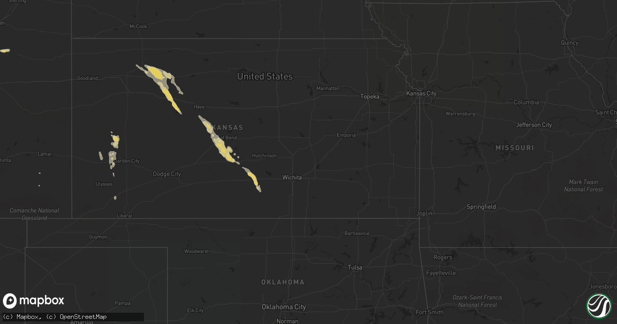
Hail Map on July 27, 2013
Get this storm
July 27 map
$229
one time, instant access
Download today. No call, no setup
Keep the $229
Bought the map and want the full workflow? Apply the entire $229 to a subscription within 7 days. None of it is wasted.
Every map, not just this one
This buys you this map. Subscription and you get every map we run, in the markets you choose from a few cities to whole states to nationwide. Plus real-time alerts the moment a storm fires.
Contact data
Name, contact info, occupancy, even credit band for addresses in the footprint. You go from where it hit to who to call.
Become the source they trust
Unlimited branding weather history reports on demand. You already have the documented answer ready for the property owner, and you are the one who showed up with it.
Property data and RoofTrace estimates
Pull up any address you have got, its value and the exact code rules for that jurisdiction, straight from One Click Code. Then RoofTrace estimates the squares, pitch, and roof value, priced the way you price.
States Impacted by Hail Map on July 27, 2013
Storm reports
New York
| Date | Description |
|---|---|
| 07/27/20136:52 PM CDT | Barn collapsed from high winds. |
| 07/27/20136:28 PM CDT | Trees down. |
| 07/27/20136:15 PM CDT | Barn collapsed from high winds. |
| 07/27/20135:10 PM CDT | Ef1 tornado had a 14 mile path length and 500 yard path width with estimated winds of 100 mph. Numerous trees and power poles were snapped along its length. A barn was |
Arizona
| Date | Description |
|---|---|
| 07/26/20137:10 PM CDT | Spotter reports 2-4 inch tree limbs down from wind gusts. |
Tennessee
| Date | Description |
|---|---|
| 07/27/201312:30 PM CDT | 3 trees down in soddy daisy |
South Carolina
| Date | Description |
|---|---|
| 07/27/20135:38 PM CDT | South carolina highway patrol reported tree blocking roadway in chapin. |
Texas
| Date | Description |
|---|---|
| 07/27/20136:05 PM CDT | Large basketball set tossed about 20 ft across yard causing damage to the porch. Small hail as well. |
| 07/27/20135:25 PM CDT | Manager of san ygnacio rv trailer park reports a number of trailers blown over and a small shed on top of a tree. |
Kansas
| Date | Description |
|---|---|
| 07/26/201311:30 PM CDT | A local report indicates 60 MPH wind near KINGMAN |
| 07/26/20139:45 PM CDT | A local report indicates 1.25 inch wind near 4 NW STAFFORD |
Florida
| Date | Description |
|---|---|
| 07/27/20133:28 PM CDT | The sanford airport asos measured a 66-knot or 76-mph wind gust out of the south at 428pm local. Tower personnel reported a loaded luggage cart was blown over onto an a |
Ohio
| Date | Description |
|---|---|
| 07/27/20134:32 PM CDT | 2 inch diameter branches down on 2 cars |
| 07/27/20134:16 PM CDT | Multiple reports of trees down throughout the city |
| 07/27/20134:15 PM CDT | Roof damage to approx 15 structures including homes businesses and apt complexes |
North Carolina
| Date | Description |
|---|---|
| 07/27/20133:17 PM CDT | Light carport at walmart was blown over |
| 07/27/20131:22 PM CDT | A few trees blown down in and around the town of denton with fire department on scene. |
| 07/27/20131:20 PM CDT | One tree blown down at loop road and mt. Zion church road. Time estimated. |
| 07/27/201312:06 PM CDT | Multiple trees down in clemmons with several on vehicles |
| 07/27/201310:50 AM CDT | Two trees down in the clemmons area |
Pennsylvania
| Date | Description |
|---|---|
| 07/27/20134:01 PM CDT | Numerous trees down. Buildings damaged. |
| 07/27/20134:00 PM CDT | Ef1 tornado confirmed south of coudersport |
| 07/27/20133:45 PM CDT | Numerous trees down. Route 34 closed between south newport and new bloomfield. |
Michigan
| Date | Description |
|---|---|
| 07/27/20133:35 PM CDT | Walker road and jacob - sharon twp...2 reports |
| 07/27/20133:25 PM CDT | Tree down blocking road near intersection of wolf lake rd and sharon valley rd. |
| 07/27/20133:18 PM CDT | Tree down blocking road on m50 near chicago rd. Also a construction sign was knocked down. |
Cities Impacted by Hail Map on July 27, 2013
- Kingman, AZ
- Kingman, KS
- Deerfield, KS
- Lakin, KS
- Penokee, KS
- Morland, KS
- Marienthal, KS
- Leoti, KS
- Grass Lake, MI
- Manchester, MI
- Chelsea, MI
- Hudson, KS
- Pawnee Rock, KS
- St John, KS
- Great Bend, KS
- Stafford, KS
- Selden, KS
- Darlington, SC
- Timmonsville, SC
- Florence, SC
- Otis, KS
- Albert, KS
- Rush Center, KS
- Bison, KS
- Hays, KS
- Schoenchen, KS
- La Crosse, KS
- Wakeeney, KS
- Arlington, KS
- Turon, KS
- Hoxie, KS
- Ogallah, KS
- Collyer, KS
- Detroit, MI
- Redford, MI
- Lindon, CO
- Woodrow, CO
- Encinal, TX
- Holcomb, KS
- Clarklake, MI
- Brooklyn, MI
- Napoleon, MI
- Jackson, MI
- Collins, GA
- Box Elder, MT
- Dragoon, AZ
- Cedar City, UT
- Hill City, KS
- Mathis, TX
- Beeville, TX
- Kaycee, WY
- Norvell, MI
- Simla, CO
- Hoboken, GA
- George West, TX
- Yoder, CO
- Rush, CO
- Ellis, KS
- Sandia, TX
- Benson, AZ
- Akron, CO
- Taylor, MI
- Dearborn Heights, MI
- Chinook, MT
- Cotulla, TX
- Metter, GA
- Spivey, KS
- Cunningham, KS
- Hardeeville, SC
- Ash Fork, AZ
- Baton Rouge, LA
- Claxton, GA
- Reidsville, GA
- Laredo, TX
- Realitos, TX
- McKenzie, AL
- Odum, GA
- Statesboro, GA
- Palco, KS
- Hoisington, KS
- Hamtramck, MI
- Highland Park, MI
- Havre, MT
- Dexter, MI
- Ann Arbor, MI
- Pembroke, GA
- Fort Stewart, GA
- Ellabell, GA
- Nahunta, GA
- Sylvia, KS
- Garrett, WY
- Kremlin, MT
- Loma, MT
- Big Sandy, MT
- Mayville, MI
- Silverwood, MI
- Victoria, TX
- Lamar, SC
- Goliad, TX
- Addis, LA
- Ulysses, KS