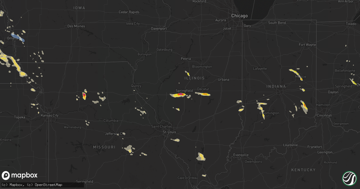
Hail Map on July 23, 2023
Get this storm
July 23 map
$229
one time, instant access
Download today. No call, no setup
Keep the $229
Bought the map and want the full workflow? Apply the entire $229 to a subscription within 7 days. None of it is wasted.
Every map, not just this one
This buys you this map. Subscription and you get every map we run, in the markets you choose from a few cities to whole states to nationwide. Plus real-time alerts the moment a storm fires.
Contact data
Name, contact info, occupancy, even credit band for addresses in the footprint. You go from where it hit to who to call.
Become the source they trust
Unlimited branding weather history reports on demand. You already have the documented answer ready for the property owner, and you are the one who showed up with it.
Property data and RoofTrace estimates
Pull up any address you have got, its value and the exact code rules for that jurisdiction, straight from One Click Code. Then RoofTrace estimates the squares, pitch, and roof value, priced the way you price.
States Impacted by Hail Map on July 23, 2023
Storm reports
Ohio
| Date | Description |
|---|---|
| 07/23/20234:55 PM CDT | 1 tree down on pleasant valley rd. Another large branch down near this location. |
| 07/23/20234:52 PM CDT | Trees and powerlines down across the county. House hit by lightning. |
| 07/23/20234:15 PM CDT | Multiple trees down in a subdivision near polaris parkway and old state road. One home with some minor siding damage. Time estimated from radar. |
| 07/23/20234:08 PM CDT | A pine tree fell into power equipment. Time estimated from radar. |
| 07/23/20233:54 PM CDT | Report from mping: quarter |
| 07/23/20233:52 PM CDT | Asos station kosu columbus ohio state university airport. |
| 07/23/20233:49 PM CDT | A tree was downed onto the road at the intersection of mccoy road at clairmont road. |
| 07/22/20237:53 PM CDT | A local report indicates 1.00 inch wind near 4 WNW Jefferson |
| 07/22/20237:25 PM CDT | Social media picture of a large tree downed. |
Idaho
| Date | Description |
|---|---|
| 07/23/20236:58 PM CDT | Tree branch 5in diameter down. Station elevation: 4520 ft. |
| 07/22/20237:50 PM CDT | Tree blown down by thunderstorm winds on fairway drive. |
| 07/22/20237:40 PM CDT | Materials from ongoing construction on knudsen blvd blown into road. |
| 07/22/20237:36 PM CDT | Asos station kpih pocatello regional airport. |
| 07/22/20237:30 PM CDT | Shingles removed from residence. Time estimated based on radar. |
| 07/22/20237:30 PM CDT | Large tree uprooted and down blocking the road near the intersection of david st and joel st. Photo provided. Time estimated based on radar. |
| 07/22/20237:25 PM CDT | Power outages in chubbuck and parts of pocatello from thunderstorm winds. |
| 07/22/20237:07 PM CDT | Large tree branch down in road. Blocking south 7th ave at east whitman st. Image shared from idaho state journal. |
South Carolina
| Date | Description |
|---|---|
| 07/23/20236:20 PM CDT | A couple of trees down and a power line down in this area. |
| 07/23/20236:16 PM CDT | 911 center reported a tree down at the intersection of hebron and dunbar road. |
| 07/23/20235:20 PM CDT | Tempest weather system... Id...pee dee rec |
| 07/23/20233:10 PM CDT | 911 call center reported 4 power poles down in the 2000 block of west frontage road. Time estimated from radar. |
| 07/23/20232:15 PM CDT | Chesterfield co 911 dispatch reported numerous trees down from the ruby and chesterfield area se towards us hwy 1 near the fish hatchery. Time estimated. |
| 07/23/20231:38 PM CDT | Tweet shows several pictures of downed trees near the intersection of hwy 9 and market st. Including one showing damage to a structure at this location near the center |
| 07/23/20231:31 PM CDT | Spotter reports trees down across highway 9 in mount croghan near hough street. |
| 07/23/20231:30 PM CDT | Email report received of two very large oaks down... Another third large oak snapped and additional damage to other trees on property. Picture shows one of the larger d |
| 07/23/20231:26 PM CDT | Tweet shows pictures of damage to an aluminum topped garage and to trees in a nearby forest near lynn automotive and center grove baptist church. Time estimated by rada |
West Virginia
| Date | Description |
|---|---|
| 07/23/20236:27 PM CDT | Numerous trees down... And some blocking roads... In the alderson area. |
| 07/23/20236:26 PM CDT | At least six trees blown down by thunderstorm winds on muddy creek mountain road. One of the trees fell into shed which was destroyed. |
| 07/22/20237:21 PM CDT | Thunderstorm winds blew down two trees along the 1000 block of crane road. |
Georgia
| Date | Description |
|---|---|
| 07/23/202312:00 PM CDT | Lee county dispatch reported a tree down on leslie hwy near 3rd st. |
| 07/23/202311:14 AM CDT | Lowndes county dispatch reports a tree on a power line on johnson st in valdosta. |
| 07/23/202311:10 AM CDT | Tree reported down caused by thunderstorm winds. |
Nevada
| Date | Description |
|---|---|
| 07/22/202310:11 PM CDT | At 8:11 pm pdt... The sensor at west career and tech academy recorded a thunderstorm wind gust of 58 mph. Data courtesy of earth networks. |
Illinois
| Date | Description |
|---|---|
| 07/23/20233:22 PM CDT | Photo of 1 inch hail relayed via social media. Time estimated from radar. |
| 07/23/20234:41 AM CDT | Large tree limb down on a home in christopher. |
| 07/23/20234:38 AM CDT | Large tree limbs down. |
| 07/22/20239:17 PM CDT | Relayed via broadcast media. |
| 07/22/20237:50 PM CDT | Nickel to quarter size hail. |
| 07/22/20237:46 PM CDT | Report from mping: quarter |
| 07/22/20237:45 PM CDT | Report from mping: quarter |
| 07/22/20237:43 PM CDT | Report from mping: quarter |
| 07/22/20237:43 PM CDT | Photo of golf ball size hail. |
| 07/22/20237:38 PM CDT | Corrects previous hail report from chatham. Social media photo of 2.5 inch hail. |
| 07/22/20237:38 PM CDT | Social media photo of 2 inch hail. |
| 07/22/20237:37 PM CDT | Report from mping: quarter |
| 07/22/20237:34 PM CDT | A local report indicates 1.00 inch wind near 1 NNE Chatham |
| 07/22/20237:30 PM CDT | Photo sent via social media. |
| 07/22/20237:21 PM CDT | Corrects previous rain report from 3 sw curran. Picture of quarter to ping pong ball size hail. Relayed via social media. |
| 07/22/20237:05 PM CDT | Highway 108 and thornbrook rd. Time estimated. |
Arizona
| Date | Description |
|---|---|
| 07/23/20236:49 PM CDT | Asos station kols nogales international airport. |
| 07/23/20235:15 PM CDT | *corrected* sedona airport awos measured a 52 knot |
| 07/22/20239:17 PM CDT | Power pole tilted and irvington road closed. |
| 07/22/20238:45 PM CDT | Multiple reports of downed power lines and power poles as well as damage to homes in the area south of ajo and west of i-19. Time estimated by radar. |
| 07/22/20238:15 PM CDT | At approximately 6:15 pm pdt... The nevershine raws recorded a thunderstorm wind gust of 61 mph. Time estimated using radar. |
South Dakota
| Date | Description |
|---|---|
| 07/23/20236:07 PM CDT | A local report indicates 67 MPH wind near 3 ESE Pine Ridge |
| 07/23/20235:47 PM CDT | A local report indicates 60 MPH wind near Sharps Corner |
| 07/23/20235:37 PM CDT | A local report indicates 60 MPH wind near Oglala |
| 07/23/20233:07 AM CDT | In addition to quarter sized hail... Shredded leaves were spread across the yard. |
| 07/23/20232:20 AM CDT | A local report indicates 1.75 inch wind near 5 NE Tyndall |
| 07/23/20232:17 AM CDT | A local report indicates 1.75 inch wind near 2 NNE Tyndall |
| 07/23/20232:12 AM CDT | A local report indicates 1.00 inch wind near Tyndall |
Utah
| Date | Description |
|---|---|
| 07/23/20236:30 PM CDT | Udot rwis sensor measured wind gust at the dog valley station |
| 07/23/20235:10 PM CDT | Measured at udot rwis site i-15 at pine creek hill. |
| 07/22/20238:05 PM CDT | Measured at the causeway mesonet site on dugway proving ground. Site dpg18. |
| 07/22/20237:15 PM CDT | Dugway mesonet station callao gate recorded measurement |
Nebraska
| Date | Description |
|---|---|
| 07/23/20235:09 AM CDT | Asos station koma omaha eppley airfield. |
| 07/23/20234:35 AM CDT | A local report indicates 1.00 inch wind near Rogers |
| 07/23/20233:22 AM CDT | A local report indicates 1.00 inch wind near 1 NNW Pilger |
| 07/23/20233:18 AM CDT | Report from mping: 1-inch tree limbs broken. |
| 07/23/20232:37 AM CDT | A local report indicates 1.00 inch wind near Mclean |
| 07/23/20232:15 AM CDT | Corrects previous hail report from creighton. |
| 07/22/202310:10 PM CDT | Thunderstorm wind gust of 79 mph recorded on a davis at home weather station. Delayed report via email. |
Kansas
| Date | Description |
|---|---|
| 07/23/20231:29 AM CDT | Awos station kcbk 2 n colby. |
Indiana
| Date | Description |
|---|---|
| 07/23/20236:55 PM CDT | Several trees down in the milan area... Incuding one that fell on a truck. |
| 07/23/20236:22 PM CDT | A tree was downed in sunman. Time estimated by radar. |
| 07/23/20235:58 PM CDT | Damage to a pool and bath house roof. Time estimated by radar. |
| 07/23/20235:50 PM CDT | Trees blown down on spades road. |
| 07/23/20234:20 PM CDT | Late report of thunderstorm winds that downed a tree on burlington drive. Time estimated from radar. Power lines were also downed on country club road. |
| 07/23/20233:46 PM CDT | Late report of thunderstorm winds that downed a tree on burlington drive. Time estimated from radar. |
| 07/23/20233:36 PM CDT | Corrects previous hail report from 1 sse prairie creek reservoir. Public report of hail up to 1.00 inches. |
| 07/23/20233:26 PM CDT | Public report of 1 inch hail. |
| 07/23/20233:25 PM CDT | Public report of hail up to 1.00 inches. |
| 07/23/20233:02 PM CDT | A local report indicates 1.50 inch wind near 1 NNW Ball State Univer |
| 07/23/20233:02 PM CDT | Public report of 1.25 inch hail nw of muncie. |
| 07/23/20232:44 PM CDT | Nws employee reported quarter size hail along i-69 near county rd 950n intersection. |
| 07/23/20232:30 PM CDT | Report from mping: quarter |
| 07/23/20232:22 AM CDT | Late report of thunderstorm winds that downed several additional trees in owen county from overnight storm. Time estimated from radar. |
| 07/22/20237:02 PM CDT | A tree damaged a house when it fell on it. Time estimated by radar. |
| 07/22/20237:00 PM CDT | Several trees down in the milan area. Time estimated by radar. |
Missouri
| Date | Description |
|---|---|
| 07/23/20234:50 PM CDT | Follow up from earlier report. Caller measured 2.5 inch hail stone in yard. |
| 07/23/20234:45 PM CDT | A local report indicates 1.00 inch wind near 5 S Meadville |
| 07/23/20234:45 PM CDT | Report of a few 6 inch limbs down. |
Florida
| Date | Description |
|---|---|
| 07/23/20234:13 PM CDT | Delayed report: tree damage near paradise park on juanita ave. |
| 07/23/20233:07 PM CDT | Public report of limbs and small trees down in palm bay |
| 07/23/20231:20 PM CDT | Oak tree fell onto home in interlachan as a result of strong thunderstorm related winds. |
| 07/23/202312:52 PM CDT | Power line down caused by thunderstorm winds. Time is radar indicated. |
| 07/23/202312:51 PM CDT | Tree down caused by thunderstorm. |
| 07/23/202312:49 PM CDT | Report of tree down over power lines caused by thunderstorm. |
| 07/23/202312:45 PM CDT | Report of tree down over henry smith road caused by thunderstorm winds. |
| 07/23/202312:43 PM CDT | Tree down over power line caused by thunderstorm winds. |
| 07/23/202312:10 PM CDT | Tree down at the cross section of copper creek drive and n county rd 23a. Time estimated using radar. |
| 07/23/202312:10 PM CDT | 911 call center reported a tree down near the intersection of hopkins road and smokey road. Time estimate based on radar imagery. |
| 07/23/202312:10 PM CDT | 911 call center reported a tree down near the intersection of north county road 23a and north tall pine road. Time estimate based on radar imagery. |
| 07/23/202311:00 AM CDT | Fallen trees or limbs resulted in a power outage along foley cut-off road. |
| 07/23/202310:55 AM CDT | Tree down caused by thunderstrorm winds. |
| 07/23/202310:50 AM CDT | Tree down caused by tstm winds. |
| 07/23/202310:47 AM CDT | Madison county dispatch reports a tree and power lines down on ne persimmon dr in pinetta. |
| 07/23/20239:50 AM CDT | Jefferson co dispatch reports a power line down on old lloyd rd near lloyd creek rd. |
Michigan
| Date | Description |
|---|---|
| 07/23/202312:50 PM CDT | Public report of large tree down near townline rd and lakeview dr. |
New Mexico
| Date | Description |
|---|---|
| 07/23/202312:30 AM CDT | Strong south wind blew through capulin breaking tree branches up to 6 inches in diameter. Blew over a shed in town. |
Texas
| Date | Description |
|---|---|
| 07/23/20236:49 PM CDT | Power poles down... No electricity. |
| 07/23/20236:10 PM CDT | Dispatch reports trees and power lines down in ganado due to thunderstorm wind damage. |
North Carolina
| Date | Description |
|---|---|
| 07/23/20235:01 PM CDT | Thunderstorm winds blew down one tree that took down power lines as it fell near the intersection of sparta road and longbottom road. |
| 07/23/20234:58 PM CDT | Thunderstorm winds blew down one tree along hilltop boulevard. |
| 07/23/202312:05 PM CDT | Duke energy reports power outage caused by fallen trees and limbs. |
Virginia
| Date | Description |
|---|---|
| 07/23/20236:59 PM CDT | Large tree blown down... Damaging and breaking three power poles along crocketts cove road. Time estimated by radar. |
| 07/23/20236:54 PM CDT | Five trees downed by thunderstorm winds along crocketts cove road. |
| 07/23/20235:27 PM CDT | Tree down. |
| 07/23/20235:20 PM CDT | Tree down. Powerlines down. |
| 07/23/20235:08 PM CDT | Multiple trees downed in hazelwood... Near the intersection of hardy road and beagle club road. |
| 07/23/20235:02 PM CDT | Tree down. |
| 07/23/20235:01 PM CDT | Powerlines down. |
| 07/23/20234:56 PM CDT | Powerlines down. |
| 07/23/20234:43 PM CDT | Powerlines down. Basement flooding. |
| 07/23/20234:41 PM CDT | Powerlines down. |
| 07/23/20234:40 PM CDT | Thunderstorm winds blew down two trees on walnut avenue near the intersection with third street. Hail up to the size of nickels also fell a few minutes earlier. |
| 07/23/20234:21 PM CDT | Tree down. |
| 07/23/20234:19 PM CDT | Tree fell on car. Powerline also down. |
| 07/23/20234:16 PM CDT | Powerlines down. |
| 07/23/20234:15 PM CDT | Tree down across powerline. |
| 07/23/20234:15 PM CDT | Tree and powerline down. |
| 07/23/20234:05 PM CDT | Numerous trees and several power lines down across the southeastern part of the city of roanoke and into the vinton area. Large trees were down at kerns and 12th street |
| 07/23/20233:50 PM CDT | Numerous trees downed by thunderstorm winds scattered around southern half of county. |
| 07/23/20233:49 PM CDT | Tree down on dolly ann drive. |
| 07/23/20233:24 PM CDT | Multiple large limbs downed by thunderstorm winds near the dixon family homeplace. |
| 07/23/20233:00 PM CDT | Tree down. |
| 07/23/20233:00 PM CDT | Tree down. |
| 07/23/20231:35 PM CDT | Trees down. |
| 07/23/20231:30 PM CDT | Multiple reports of trees down in stuart. |
| 07/23/20231:28 PM CDT | Tree down. |
| 07/22/20237:49 PM CDT | Numerous trees downed by thunderstorm winds through eastern part of giles county... Many in the staffordsville area. |
| 07/22/20237:01 PM CDT | One tree down off little creek highway. |
Cities Impacted by Hail Map on July 23, 2023
- Hale Center, TX
- Anton, TX
- Oakfield, GA
- Warwick, GA
- Fairmount, IN
- Summitville, IN
- Gaston, IN
- Muncie, IN
- Cambridge City, IN
- Straughn, IN
- Meadville, MO
- Chillicothe, MO
- Sumner, MO
- Greensburg, IN
- Laurel, IN
- Oldenburg, IN
- Batesville, IN
- Metamora, IN
- Solsberry, IN
- Hale, MO
- Pine Ridge, SD
- Kyle, SD
- Porcupine, SD
- Sunman, IN
- Huntsville, MO
- Clifton Hill, MO
- Palmyra, MO
- Gonzales, TX
- Mount Croghan, SC
- Ruby, SC
- Cibolo, TX
- Williams, AZ
- Silex, MO
- Cost, TX
- Bandera, TX
- Chesterfield, SC
- Golden Meadow, LA
- Seguin, TX
- Happy Jack, AZ
- Rockport, IL
- New Canton, IL
- Hallettsville, TX
- Brunswick, MO
- Spencer, IN
- Marengo, OH
- Sunbury, OH
- New Cambria, MO
- Rushville, IN
- Mico, TX
- Connersville, IN
- Lewisville, IN
- Marysville, OH
- Kenton, OH
- Del Rio, TX
- Bowling Green, MO
- Emden, IL
- Hartsburg, IL
- Pennville, IN
- Dunkirk, IN
- Medina, TX
- Laclede, MO
- Salisbury, MO
- Centerburg, OH
- Poland, IN
- Bloomfield, IN
- Bowling Green, IN
- Portland, IN
- Helotes, TX
- Lincoln, IL
- Boerne, TX
- Springfield, SC
- Texas City, TX
- Victoria, TX
- Mount Victory, OH
- Hilliard, OH
- Columbus, OH
- Middletown, MO
- Delaware, OH
- Marion, TX
- Saint Hedwig, TX
- Schertz, TX
- Converse, TX
- Jacksonville, FL
- Jacksonville Beach, FL
- Uvalde, TX
- Yorktown, IN
- Elwood, IN
- Mooreland, IN
- Alexandria, IN
- Curryville, MO
- Leesville, TX
- Bowman, SC
- Vandalia, MO
- Dublin, OH
- Powell, OH
- Eolia, MO
- Upland, IN
- Hartford City, IN
- San Jose, IL
- Green Valley, IL
- Delavan, IL
- Excello, MO
- Hilliard, FL
- Allen, SD
- Cheraw, SC
- Patrick, SC
- Pageland, SC
- La Vernia, TX
- Damon, TX
- Cut Off, LA
- Callao, MO
- Findlay, OH
- Reelsville, IN
- San Antonio, TX
- Rio Frio, TX
- Nixon, TX
- Brackettville, TX
- Keytesville, MO
- Sweeny, TX
- Alexander, IL
- Waverly, IL
- New Berlin, IL
- Loami, IL
- Chatham, IL
- Carlinville, IL
- Springfield, IL
- Mechanicsburg, OH
- Irwin, OH
- London, OH
- Glenarm, IL
- Pawnee, IL
- West Jefferson, OH
- Macon, IL
- Dalton City, IL
- Bethany, IL
- Houstonia, MO
- Saint Paul, IN
- Whitman, NE
- Wytheville, VA
- Dawn, MO
- Hettick, IL
- Chesterfield, IL
- Springville, IN
- Fillmore, IN
- Coatesville, IN
- Milford Center, OH
- Arthur, NE
- Hyannis, NE
- Ashby, NE
- Franklin, IL
- Croton, OH
- Rochester, IL
- New Castle, IN
- Chadron, NE
- Yoakum, TX
- Westport, IN
- Edinburg, IL
- Bingham, NE
- Mullen, NE
- Valentine, NE
- Hughesville, MO
- Marshall, MO
- Taylorville, IL
- Goliad, TX
- Cuero, TX
- Bogard, MO
- Osgood, IN
- Milan, IN
- Stapleton, NE
- Ganado, TX
- Edna, TX
- Maxwell, NE
- Auburn, IL
- Moweaqua, IL
- Blue Mound, IL
- Martin, SD
- Woodstock, OH
- North Vernon, IN
- Young, AZ
- Gillespie, IL
- Galloway, OH
- Petersburg, IL
- Tina, MO
- Sedalia, MO
- Jacksonville, IL
- Beeville, TX
- Van Vleck, TX
- Red Springs, NC
- Creighton, NE
- Springfield, SD
- Niobrara, NE
- Parkston, SD
- Plainview, NE
- Tyndall, SD
- Tabor, SD
- Scotland, SD
- Osmond, NE
- Wausa, NE
- Lesterville, SD
- Randolph, NE
- Mclean, NE
- Ethan, SD
- Dimock, SD
- Wisner, NE
- Pilger, NE
- Concord, NE
- Wakefield, NE
- Allen, NE
- Emerson, NE
- Dodge, NE
- Howells, NE
- Unadilla, NE
- Syracuse, NE
- Rogers, NE
- Linwood, NE
- Morse Bluff, NE
- North Bend, NE
- Brady, NE
- Wahoo, NE
- Martinsville, IN
- Monrovia, IN
- Stilesville, IN
- Stockton, KS
- Cuba, MO
- Owensville, MO
- Royal, NE
- Hutchinson, MN
- Armour, SD
- Malmo, NE
- Cedar Bluffs, NE
- Schuyler, NE
- Bourbon, MO
- Saint James, MO
- Vichy, MO
- Atwood, KS
- Freeburg, IL
- Farmersburg, IN
- West Union, IL
- Terre Haute, IN
- Oberlin, KS
- Benton, IL
- Buckner, IL
- Mulkeytown, IL
- Christopher, IL
- Litchfield, MN
- Columbia, IL
- Millstadt, IL
- Paris, IL
- Dennison, IL
- Scribner, NE
- Wilsonville, NE
- Norton, KS
- Plainville, KS
- Bland, MO
- Belle, MO
- Marshall, IL
- Quincy, IN
- Cloverdale, IN
- Gosport, IN
- Rexford, KS
- Colby, KS
- Scipio, IN
- Hershey, NE
- Stanton, NE
- Steelville, MO
- Salley, SC
- Smithton, IL
- New Athens, IL
- Linn, MO
- Loose Creek, MO
- Cambridge, NE
- Clarkson, NE
- Chamois, MO
- Bonnots Mill, MO
- Paragon, IN
- Centerpoint, IN
- Brunswick, NE
- Vienna, MO
- Weston, NE
- Jefferson City, MO
- Pender, NE
- Eustis, NE
- Colon, NE
- Hartsville, IN
- Columbus, IN
- Crescent, IA
- Omaha, NE
- Carter Lake, IA
- Council Bluffs, IA
- Treynor, IA
- McClelland, IA
- Silver City, IA
- Macedonia, IA
- Carson, IA
- Vermillion, SD
- Tekamah, NE
- West Point, NE
- Underwood, IA
- Olivet, SD
- Tripp, SD
- Neola, IA
- Minden, IA
- Winside, NE
- Hoskins, NE
- Gayville, SD
- Nemaha, NE
- Brownville, NE
- Eagle, NE
- Palmyra, NE
- Corsica, SD
- Prague, NE
- Craig, MO
- Hamburg, IA
- Mascoutah, IL
- Bancroft, NE
- Carroll, NE
- Pierce, NE
- Mitchell, SD
- Mount Vernon, SD
- Cummings, KS
- Atchison, KS
- Nebraska City, NE
- Rosalie, NE
- Lyons, NE
- Little Sioux, IA
- Mondamin, IA
- Gretna, NE
- Ashland, NE
- Waterloo, NE
- Avoca, IA
- Decatur, NE
- Craig, NE
- Oakland, NE
- Bloomfield, NE
- Yankton, SD
- Avon, SD
- Utica, SD
- Crofton, NE
- Lutherville Timonium, MD
- Pikesville, MD
- Stevenson, MD
- Owings Mills, MD
- Talmage, NE
- Brock, NE
- Cook, NE
- Peru, NE
- Alvo, NE
- Elmwood, NE
- Orient, IL
- West Frankfort, IL
- Johnston City, IL
- Freeman Spur, IL
- Zeigler, IL
- Herrin, IL
- Avoca, NE
- Otoe, NE
- Belden, NE
- Wayne, NE
- Laurel, NE
- Carterville, IL
- De Soto, IL
- Hurst, IL
- Royalton, IL
- Marion, IL
- Fort Calhoun, NE
- Shubert, NE
- Falls City, NE
- Dunlap, IA
- Waterbury, NE
- Jackson, NE
- Honey Creek, IA
- Missouri Valley, IA
- Delmont, SD
- Johnson, NE
- Auburn, NE
- Easton, KS
- Coal City, IN
- Patricksburg, IN
- Freedom, IN
- Mission Hill, SD
- Fairfax, MO
- Blair, NE
- Waverly, NE
- Ceresco, NE
- Ithaca, NE
- Greenwood, NE
- Belknap, IL
- Vienna, IL
- Bern, KS
- Douglas, NE
- Burr, NE
- Sterling, NE
- Malvern, IA
- Troy, KS
- Highland, KS
- Du Bois, IL
- Tamaroa, IL
- Alexandria, SD
- Magnet, NE
- Winnetoon, NE
- Du Bois, NE
- Kennard, NE
- Bennet, NE
- Dunbar, NE
- Rock Port, MO
- Murdock, NE
- Walton, NE
- Julian, NE
- Clarinda, IA
- Villisca, IA
- Oakley, KS
- Shelby, IA
- Hancock, IA
- Bedford, IA
- Leavenworth, KS
- Lisle, NY
- Marathon, NY
- Berkshire, NY
- Richford, NY
- Oregon, MO
- Barnard, MO
- Rulo, NE
- Braddyville, IA
- Forest City, MO
- Mound City, MO
- Essex, IA
- Skidmore, MO
- New Market, IA
- Nodaway, IA
- Gravity, IA
- Hastings, IA
- Coin, IA
- Henderson, IA
- Watson, MO
- Basehor, KS
- Tonganoxie, KS
- Shenandoah, IA
- Winchester, KS
- Pickering, MO
- Burlington Junction, MO
- Maryville, MO
- Graham, MO