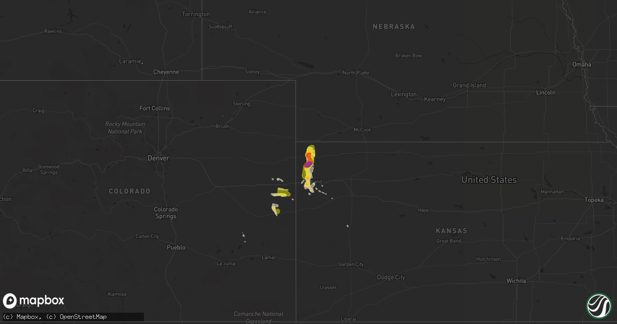
Hail Map on July 18, 2014
Get this storm
July 18 map
$229
one time, instant access
Download today. No call, no setup
Keep the $229
Bought the map and want the full workflow? Apply the entire $229 to a subscription within 7 days. None of it is wasted.
Every map, not just this one
This buys you this map. Subscription and you get every map we run, in the markets you choose from a few cities to whole states to nationwide. Plus real-time alerts the moment a storm fires.
Contact data
Name, contact info, occupancy, even credit band for addresses in the footprint. You go from where it hit to who to call.
Become the source they trust
Unlimited branding weather history reports on demand. You already have the documented answer ready for the property owner, and you are the one who showed up with it.
Property data and RoofTrace estimates
Pull up any address you have got, its value and the exact code rules for that jurisdiction, straight from One Click Code. Then RoofTrace estimates the squares, pitch, and roof value, priced the way you price.
States Impacted by Hail Map on July 18, 2014
Storm reports
South Dakota
| Date | Description |
|---|---|
| 07/18/20145:20 PM CDT | Strong winds lasted about 5 minutes |
Mississippi
| Date | Description |
|---|---|
| 07/18/20144:10 PM CDT | Numerous trees and power lines downed along cr 630 in southeast clarke county. Some downed trees on houses. |
| 07/18/20142:28 PM CDT | Trees down and tin blown off roofs |
Louisiana
| Date | Description |
|---|---|
| 07/18/201411:22 AM CDT | Five trees blown down. |
North Dakota
| Date | Description |
|---|---|
| 07/17/201411:50 PM CDT | A local report indicates 1.00 inch wind near 5 N VICTOR |
| 07/17/201411:50 PM CDT | Quarter size hail near the nd/sd border...time and location estimated from public facebook post. |
Colorado
| Date | Description |
|---|---|
| 07/17/20147:11 PM CDT | A local report indicates 1.00 inch wind near 10 S BURLINGTON |
Kansas
| Date | Description |
|---|---|
| 07/18/20146:54 PM CDT | A local report indicates 1.00 inch wind near 12 N WHEELER |
| 07/17/20149:35 PM CDT | A local report indicates 1.00 inch wind near 3 E RULETON |
| 07/17/20149:34 PM CDT | Most stones penny to quarter sized. |
| 07/17/20149:23 PM CDT | A local report indicates 1.25 inch wind near 5 W GOODLAND |
| 07/17/20149:23 PM CDT | A local report indicates 63 MPH wind near 5 W GOODLAND |
| 07/17/20149:14 PM CDT | A local report indicates 1.25 inch wind near 5 W GOODLAND |
| 07/17/20148:55 PM CDT | A local report indicates 65 MPH wind near 11 NNE RULETON |
| 07/17/20148:28 PM CDT | Power lines down. Grass fire resulted from live wires on the ground at intersection of road d and road 7. Time estimated by radar. |
| 07/17/20147:57 PM CDT | Near airport... Some large hail storms also observed but unable to estimate at this time. |
| 07/17/20147:54 PM CDT | A local report indicates 1.50 inch wind near ST. FRANCIS |
| 07/17/20147:53 PM CDT | A local report indicates 1.00 inch wind near WHEELER |
| 07/17/20147:51 PM CDT | Running water in ditches and ponding in yard. 0.75 inches of rain in 30 minutes. |
| 07/17/20147:51 PM CDT | A local report indicates 1.00 inch wind near WHEELER |
California
| Date | Description |
|---|---|
| 07/18/20146:13 PM CDT | Trained weather spotter reported quarter sized hail and heavy rainfall. Spotter also reported a wildfire. |
Cities Impacted by Hail Map on July 18, 2014
- Bethune, CO
- Stratton, CO
- Burlington, CO
- Hankinson, ND
- Fairmount, ND
- Las Vegas, NM
- Oglala, SD
- Pine Ridge, SD
- New Effington, SD
- Sisseton, SD
- Rosholt, SD
- Oldham, SD
- De Smet, SD
- Howard, SD
- Allen, SD
- Cuervo, NM
- Wagon Mound, NM
- Hermosa, SD
- Santa Rosa, NM
- Custer, SD
- Ashley, ND
- Fredonia, ND
- Forbes, ND
- Cody, NE
- Ramona, SD
- Woodworth, ND
- Sapello, NM
- Rociada, NM
- Buena Vista, NM
- Barry, MN
- Dumont, MN
- Nenzel, NE
- Kilgore, NE
- Tuthill, SD
- Goodland, KS
- Jud, ND
- Montpelier, ND
- Cleveland, ND
- Saint Francis, KS
- Petersburg, ND
- Guadalupita, NM
- Ocate, NM
- Grafton, ND
- Aneta, ND
- Springer, NM
- Porcupine, SD
- Kyle, SD
- Beckwourth, CA
- Kit Carson, CO
- Cheyenne Wells, CO
- Graceville, MN
- Beardsley, MN
- Loyalton, CA
- Lake Preston, SD
- Portola, CA
- Mora, NM
- Susanville, CA
- Kulm, ND
- Conchas Dam, NM
- Solano, NM
- Janesville, CA
- Wheaton, MN
- Clinton, MN
- Ortonville, MN
- Wahpeton, ND
- Mantador, ND
- Claire City, SD
- Barney, ND
- Mooreton, ND
- Wounded Knee, SD
- Batesland, SD
- Martin, SD
- Gordon, NE
- Rushville, NE
- Hot Springs, SD
- Medina, ND
- Raton, NM
- Mills, NM
- Trementina, NM
- Jamestown, ND
- Cleveland, NM
- Corona, SD
- Big Stone City, SD
- Arlington, SD
- Edson, KS
- Scott City, KS
- Keystone, SD
- Mayhill, NM
- Marietta, MN
- Wyndmere, ND
- Fort Sumner, NM
- Mchenry, ND
- Rainsville, NM
- Dazey, ND
- Browns Valley, MN
- Manderson, SD
- Weston, WY
- Gackle, ND
- Binford, ND
- Pingree, ND
- Garita, NM
- Haswell, CO
- Gulf Shores, AL
- Maxwell, NM
- South Lake Tahoe, CA
- Montezuma, NM
- Coleville, CA
- Kensal, ND
- Glenfield, ND
- Sundance, WY
- Kanorado, KS