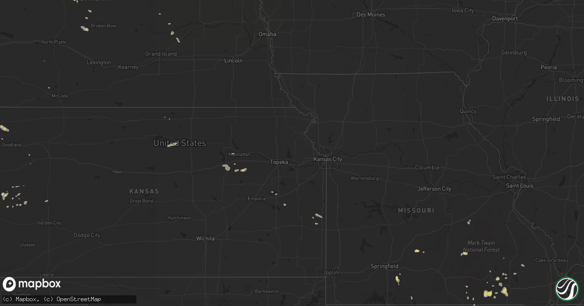
Hail Map on July 6, 2011
Get this storm
July 6 map
$229
one time, instant access
Download today. No call, no setup
Keep the $229
Bought the map and want the full workflow? Apply the entire $229 to a subscription within 7 days. None of it is wasted.
Every map, not just this one
This buys you this map. Subscription and you get every map we run, in the markets you choose from a few cities to whole states to nationwide. Plus real-time alerts the moment a storm fires.
Contact data
Name, contact info, occupancy, even credit band for addresses in the footprint. You go from where it hit to who to call.
Become the source they trust
Unlimited branding weather history reports on demand. You already have the documented answer ready for the property owner, and you are the one who showed up with it.
Property data and RoofTrace estimates
Pull up any address you have got, its value and the exact code rules for that jurisdiction, straight from One Click Code. Then RoofTrace estimates the squares, pitch, and roof value, priced the way you price.
States Impacted by Hail Map on July 6, 2011
Storm reports
Vermont
| Date | Description |
|---|---|
| 07/06/20114:51 PM CDT | Trees down on routes 100 and 100a |
| 07/06/20114:42 PM CDT | Trees down |
| 07/06/20114:40 PM CDT | Trees down on routes 100 and 100a |
| 07/06/20114:09 PM CDT | Trees and power lines down on walker hill road |
| 07/06/20113:50 PM CDT | Numerous reports of trees down |
| 07/06/20113:50 PM CDT | Numerous reports of trees down |
| 07/06/20113:45 PM CDT | Tree down |
| 07/06/20113:25 PM CDT | Trees down on route 114 in east haven |
| 07/06/20113:25 PM CDT | Trees down along boulder beach road |
| 07/06/20113:25 PM CDT | Trees down along route 5 |
| 07/06/20113:20 PM CDT | Trees and lines down |
| 07/06/20113:20 PM CDT | Tree down on route 5 |
| 07/06/20113:13 PM CDT | Trees down on route 100 |
| 07/06/20113:02 PM CDT | Trees down on route 2 |
| 07/06/20112:55 PM CDT | Tree down at the intersection of culver hill road and route 12 |
| 07/06/20112:53 PM CDT | Trees down and power outages |
| 07/06/20112:53 PM CDT | Trees down and power outages |
| 07/06/20112:53 PM CDT | Trees down and power outages |
| 07/06/20112:53 PM CDT | Trees down and power outages |
| 07/06/20112:50 PM CDT | Cherry-sized hail |
| 07/06/20112:48 PM CDT | Small trees down |
| 07/06/20112:45 PM CDT | Large tree down blocking sky acres road |
| 07/06/20112:40 PM CDT | Tree down over railroad tracks |
| 07/06/20112:35 PM CDT | Trees down |
| 07/06/20112:30 PM CDT | Several trees and power lines down |
| 07/06/20112:30 PM CDT | Trees and power lines down |
| 07/06/20112:30 PM CDT | Trees and signs down throughout morrisville |
| 07/06/20112:30 PM CDT | 3 to 5 inch diameter trees snapped along route 36 near bakersfield |
| 07/06/20112:30 PM CDT | 3 inch diameter branches down |
| 07/06/20112:20 PM CDT | Many trees as large as 12 inches down between monkton and hinesburg |
| 07/06/20112:19 PM CDT | Power lines down in addison blocking route 22a |
| 07/06/20112:05 PM CDT | Scattered trees and large branches throughout williston. |
| 07/06/20112:05 PM CDT | 14-inch diameter pine tree on industrial avenue |
| 07/06/20112:05 PM CDT | Numerous reports of tree damage |
| 07/06/20112:05 PM CDT | Trees uprooted along hayes avenue |
| 07/06/20112:05 PM CDT | Trees down throughout shelburne |
| 07/06/20112:05 PM CDT | Numerous trees uprooted along martindale road |
| 07/06/20112:00 PM CDT | Several trees and power lines down |
| 07/06/20112:00 PM CDT | Trees down and roof blown off garage |
| 07/06/20111:58 PM CDT | Quarter-sized hail on north avenue |
| 07/06/20111:56 PM CDT | 10 inch diameter tree down |
| 07/06/20111:56 PM CDT | Quarter-sized hail on riverside avenue |
| 07/06/20111:55 PM CDT | Numerous trees down and roof silo blown off along rollin irish road |
| 07/06/20111:55 PM CDT | Reported by the public |
| 07/06/20111:55 PM CDT | Trees and power lines down- east road impassable |
| 07/06/20111:51 PM CDT | Trees down and nickel-sized hail |
| 07/06/20111:50 PM CDT | Trees down on power lines on route 7 |
| 07/06/20111:50 PM CDT | Trees down and power outages |
| 07/06/20111:50 PM CDT | Trees down and power outages |
| 07/06/20111:50 PM CDT | Trees down along watkins road |
| 07/06/20111:40 PM CDT | 10 inch diameter tree down on a car... 1 inch hail measured |
| 07/06/20111:40 PM CDT | 10 inch diameter tree down on a car... 1 inch hail measured |
New Jersey
| Date | Description |
|---|---|
| 07/06/20114:12 PM CDT | Trees down in plumstead township. |
| 07/06/20114:05 PM CDT | Large limb down across from the new hanover municipal complex. |
| 07/06/20113:55 PM CDT | Large pine uprooted and smashed part of fencing. |
| 07/06/20113:53 PM CDT | County route 537 closed between new jersey state route 68 and wrightstown georgetown road because of a downed tree. |
| 07/06/20113:52 PM CDT | Mount pleasant road closed because of downed trees. |
| 07/06/20113:50 PM CDT | Numerous medium to large limbs down in yorkshire terrace section. |
| 07/06/20113:48 PM CDT | Georgetown road closed because of downed trees. |
| 07/06/20113:45 PM CDT | Trees down in florence township. |
| 07/06/20113:45 PM CDT | 62 mph gust measured in florence township. |
| 07/06/20113:43 PM CDT | Large limbs down along state route 68... Also in springfield township. |
| 07/06/20113:39 PM CDT | Large limbs down |
| 07/06/20112:50 PM CDT | Numerous trees and wires down within the township. |
| 07/06/20112:48 PM CDT | A local report indicates 60 MPH wind near HAMILTON TWP |
| 07/06/20112:30 PM CDT | Trees and wires reported down. |
| 07/06/20111:27 PM CDT | Trees and wires reported down. |
| 07/06/20111:00 PM CDT | Trees and wires reported down in east windsor. |
Wyoming
| Date | Description |
|---|---|
| 07/05/20118:28 PM CDT | Mostly penny sized with some nickel to quarter sized hail mixed in. |
| 07/05/20118:26 PM CDT | A local report indicates 1.00 inch wind near 1 NNE CODY |
New Hampshire
| Date | Description |
|---|---|
| 07/06/20116:30 PM CDT | Wires down on route 12. |
| 07/06/20116:23 PM CDT | Trees down on wires on eaton rd... Centerview circle area and bolton rd. |
| 07/06/20116:17 PM CDT | Tree down on wires on back ashuelot road about 0.5 miles from route 10 |
| 07/06/20115:05 PM CDT | Trees blown down on power lines in center ossipee. |
| 07/06/20113:50 PM CDT | Trees down parker hill rd |
| 07/06/20113:40 PM CDT | Trees down on route 3 in town. Time estimated from radar. |
| 07/06/20113:40 PM CDT | Trees down bocking the road in town. |
| 07/06/20113:36 PM CDT | Trees down blocking the road in both directions. Time estimated from radar. |
Virginia
| Date | Description |
|---|---|
| 07/06/20113:10 PM CDT | Multiple trees down near spring grove along route 10 and along spring grove rd blocking roads in places |
| 07/06/20112:57 PM CDT | Tree down on rte 10 at nobles road |
| 07/06/20112:42 PM CDT | Tree down at jordan point rd and rte 10 |
| 07/06/20112:38 PM CDT | Tree down on ruffin rd. |
| 07/06/20112:00 PM CDT | Large limb down on rt 10 near osborne rd. |
| 07/06/20111:55 PM CDT | Tree down chester road and rte 10. Nickel and quarter size hail |
| 07/06/20111:55 PM CDT | Vacant building had back wall blown out |
| 07/06/20111:27 PM CDT | Trees down |
| 07/06/201111:53 AM CDT | Trees down |
Connecticut
| Date | Description |
|---|---|
| 07/05/20119:40 PM CDT | Large limbs down on wires along firetown road |
North Carolina
| Date | Description |
|---|---|
| 07/06/20116:41 PM CDT | Trained skywarn spotter reports measured wind gust of 65 mph in surl. |
| 07/06/20116:41 PM CDT | Trained spotter observed quarter size hail in surl |
| 07/06/20116:05 PM CDT | Spotter reported several trees down in town of roxboro |
| 07/06/20115:22 PM CDT | 6 inch tree limb down on a house on old tar road. Time estimated from radar. |
| 07/06/20115:20 PM CDT | Powerlines down on jacksontown road. Time estimated from radar. |
| 07/06/20114:20 PM CDT | Hoke co 911 has received reports by local law enforcement of numerous trees and power lines down in raeford. Areas of localized flooding has also been observed. |
| 07/06/20113:48 PM CDT | Scotland co 911 has received numerous reports of trees and power lines down throughout county |
| 07/06/20113:40 PM CDT | Scotland co 911 has received numerous reports of trees and power lines down throughout county |
| 07/06/20113:33 PM CDT | A local report indicates 1.75 inch wind near 5 SSE ELKIN |
| 07/06/20113:05 PM CDT | County reports one tree down along nix creek road. The public also reported trees down in the marion area at this time. |
| 07/06/20112:37 PM CDT | Trees down along ararat road. |
| 07/06/20112:20 PM CDT | Tree down on s. Mckinney road. |
| 07/06/20112:03 PM CDT | Trees down along wedgewood drive. |
California
| Date | Description |
|---|---|
| 07/06/20115:00 PM CDT | Power lines down at south d and east 7th streets in perris due to wind. |
| 07/06/20115:00 PM CDT | Power lines down at ethanac road and evans road west of romoland around 300 pm due to wind. |
| 07/06/20115:00 PM CDT | Power lines down in the 27900 block of washington street around 300 pm due to wind. |
| 07/06/20113:30 PM CDT | Large branches down from a mimosa tree. |
Montana
| Date | Description |
|---|---|
| 07/06/20116:50 PM CDT | Now very heavy rain |
| 07/06/20116:31 PM CDT | 0.7 inches of rain too |
| 07/06/20116:26 PM CDT | A local report indicates 1.00 inch wind near RED LODGE |
| 07/05/20117:45 PM CDT | Also reported minor flooding |
| 07/05/20117:18 PM CDT | Report from traveller on i-90 |
Arkansas
| Date | Description |
|---|---|
| 07/06/20115:44 PM CDT | Reported limbs down and estimated 50-60 mph gust. |
New York
| Date | Description |
|---|---|
| 07/06/20115:18 PM CDT | Tree limbs down |
| 07/06/20115:11 PM CDT | Trees down |
| 07/06/20115:08 PM CDT | Trees down |
| 07/06/20114:54 PM CDT | Trees down. Trees blocking road |
| 07/06/20114:45 PM CDT | Trees down |
| 07/06/20114:30 PM CDT | Trees down |
| 07/06/20114:27 PM CDT | Trees and wires down |
| 07/06/20114:08 PM CDT | Numerous trees down |
| 07/06/20113:49 PM CDT | Trees and wires down |
| 07/06/20113:45 PM CDT | Several areas with trees down |
| 07/06/20113:28 PM CDT | Tree and wires down |
| 07/06/20113:15 PM CDT | Trees down. Several lightning strikes |
| 07/06/20113:09 PM CDT | 6-12 trees down across county route 110 |
| 07/06/20113:09 PM CDT | Numerous trees and wires down. Many trees uprooted |
| 07/06/20112:57 PM CDT | A local report indicates 1.25 inch wind near VALLEY FALLS |
| 07/06/20112:45 PM CDT | A local report indicates 1.00 inch wind near ORISKANY |
| 07/06/20112:31 PM CDT | A local report indicates 1.00 inch wind near ROUND LAKE |
| 07/06/20112:28 PM CDT | Just to west of exit 11 of the nys northway. |
| 07/06/20112:20 PM CDT | Trees and wires down on young avenue and on lepper road. |
| 07/06/20112:20 PM CDT | Two trees down on wires on baldwin road in cranesville and completely blocking the road. |
| 07/06/20111:20 PM CDT | Trees powerlines down on route 3 and along tom miller rd |
| 07/06/20111:20 PM CDT | Trees down across rt 22b |
| 07/06/201112:53 PM CDT | Trees down on propane tank |
South Dakota
| Date | Description |
|---|---|
| 07/06/20112:40 PM CDT | Sd dot road weather observation. |
| 07/06/201112:14 PM CDT | Sustained 40-50 |
Arizona
| Date | Description |
|---|---|
| 07/06/20116:55 PM CDT | Recorded at bisbee-douglas international airport |
Colorado
| Date | Description |
|---|---|
| 07/06/20116:21 PM CDT | A local report indicates 1.00 inch wind near 6 S PROSPECT VALLEY |
| 07/06/20116:15 PM CDT | Estimated 1 inch of rain in 10-15 minutes |
| 07/06/20115:53 PM CDT | Sustained 35-45 with gusts 50 to 59 mph. Rw+ but no hail. |
| 07/06/20115:05 PM CDT | 0.42 inch rainfall in less than 10 minutes |
| 07/05/201110:30 PM CDT | Abandon...unanchored mobile home flipped on roof by straight line winds at cr13 between highway 50 and highway 96. Estimated 3-4 cottonwood trees down. |
| 07/05/201110:30 PM CDT | Public reported barn destroyed 2 miles north and 2 miles east of lamar. Time estimated. |
| 07/05/201110:08 PM CDT | Roof blown off barn 1 mile west of bent/prowers county line on highway 50. Power out in the john martin reservoir area. |
| 07/05/20119:49 PM CDT | A local report indicates 66 MPH wind near 4 W LAMAR |
Pennsylvania
| Date | Description |
|---|---|
| 07/06/20114:05 PM CDT | Large limb down across from the new hanover municipal complex. |
| 07/06/20112:51 PM CDT | 10 inch diameter tree branch down |
Nebraska
| Date | Description |
|---|---|
| 07/06/20116:26 PM CDT | Very heavy horizontal rainfall with estimated 60 to 70 mph wind gusts. |
| 07/05/20119:00 PM CDT | Wind damage to trees from decaying thunderstorms. Large pine tree was topped and large limb of tree broken off another tree. |
| 07/05/20117:19 PM CDT | A local report indicates 60 MPH wind near 5 SE ELLSWORTH |
| 07/05/20117:00 PM CDT | Thunderstorm wind gusts broke tree branches. |
Maine
| Date | Description |
|---|---|
| 07/06/20116:40 PM CDT | Large branches down on roads which had to be removed by dot |
| 07/06/20116:35 PM CDT | Trees down on power lines on belvedere road. |
| 07/06/20116:30 PM CDT | Trees down on power lines |
| 07/06/20116:10 PM CDT | Also winds estimated 45 to 50 mph. |
| 07/06/20116:06 PM CDT | Trees down |
| 07/06/20115:55 PM CDT | Multiple reports trees down |
| 07/06/20115:53 PM CDT | Trees down garfield rd |
| 07/06/20115:50 PM CDT | Numerous trees down |
| 07/06/20115:50 PM CDT | Trees down in garland |
| 07/06/20115:50 PM CDT | Trees down on wires |
| 07/06/20115:50 PM CDT | 8in tree down in yard |
| 07/06/20115:45 PM CDT | Trained spotter esimates wind speed at 50 mph. Reports numerous branches 4 inches in diameter broken. Also reports very heavy rain. |
| 07/06/20115:45 PM CDT | Two large trees snapped on private property |
| 07/06/20115:42 PM CDT | Trees down rt 219 and rr 140 |
| 07/06/20115:40 PM CDT | Trees down |
| 07/06/20115:40 PM CDT | Numerous trees down |
| 07/06/20115:30 PM CDT | Numerous trees down |
| 07/06/20115:25 PM CDT | A local report indicates 67 MPH wind near 1 E SANGERVILLE |
| 07/06/20115:24 PM CDT | Trees down paris hill rd |
| 07/06/20115:15 PM CDT | Numerous trees down |
| 07/06/20115:05 PM CDT | Trees down on wires |
| 07/06/20115:00 PM CDT | Numerous trees down in and around jay |
| 07/06/20115:00 PM CDT | Trees down on wires |
| 07/06/20115:00 PM CDT | Top hat rd trees down |
| 07/06/20114:45 PM CDT | Trees down at long falls dam and on school st in new portland |
| 07/06/20114:40 PM CDT | Trees down on wires near weld |
| 07/06/20114:30 PM CDT | Numerous reports of trees down |
| 07/06/20114:30 PM CDT | Numerous trees down in rumford corner...one on a house. Time estimated from radar. Delayed report. |
| 07/06/20114:30 PM CDT | Significant tree damage in and around hanover. Numerous 80 to 90 year old pine trees snapped or uprooted. Delayed report. |
| 07/06/20114:20 PM CDT | Delayed report. |
| 07/06/20114:20 PM CDT | Estimated 50 to 60 mph winds at this time. |
| 07/06/20114:20 PM CDT | Numerous trees down on route 2 in hanover. Time estimated from radar. |
| 07/06/20114:10 PM CDT | Numerous trees down throughout rumford |
| 07/05/20117:15 PM CDT | Large 200 year old tree was uprooted. Other smaller trees also toppled. |
Massachusetts
| Date | Description |
|---|---|
| 07/06/20116:35 PM CDT | Tree down blocking elm street |
| 07/06/20116:35 PM CDT | Tree and wires down on prospect heights lane |
| 07/06/20116:14 PM CDT | 8 inch diameter tree limbs down on river road |
| 07/06/20116:09 PM CDT | Trees and wires down on brook road |
| 07/06/20116:04 PM CDT | Tree down on long hill road |
| 07/06/20115:30 PM CDT | Several trees down and damage to gazeebo. |
| 07/05/20117:29 PM CDT | Trees down on wires on miller and east streets |
| 07/05/20117:26 PM CDT | Tree down on wires on chapin street |
| 07/05/20117:25 PM CDT | Tree down on house on francis avenue...no damage to home |
| 07/05/20117:20 PM CDT | Large limb down on wires on walker road |
South Carolina
| Date | Description |
|---|---|
| 07/06/20113:55 PM CDT | Tree down on driggers road near dunbar highway |
| 07/06/20113:42 PM CDT | Tree down at 400 w billy farrow highway |
| 07/06/20113:29 PM CDT | Trees blown down at old river rd off sc hwy 912 |
| 07/06/20113:25 PM CDT | Trees blown down on brickyard rd at sc hwy 912 |
| 07/06/20113:12 PM CDT | Tree down on rogers street near warren street |
| 07/06/20113:12 PM CDT | Trees down on highway 177 |
| 07/06/20113:04 PM CDT | Trees down indian swamp road and highway 512 |
| 07/06/20113:04 PM CDT | Trees down on old georgetown road and highway 261 |
| 07/06/20113:00 PM CDT | Tree down 12800 block of round o road. |
| 07/06/20112:52 PM CDT | Sheriff reported several trees down on hwy 341 in lynchburg. |
| 07/06/20112:48 PM CDT | Power poles down...numerous trees down...barn roof blown offin the area of 3081 st. Charles road. |
| 07/06/20112:45 PM CDT | Trees down along highway 178 near star fort pond road. |
| 07/06/20112:40 PM CDT | Trees down at gold mine road and highway 221. |
| 07/06/20112:35 PM CDT | Tree down on sc hwy 336 near honey hill subdivision. |
| 07/06/20112:27 PM CDT | Post office reported quarter size hail in teh area and estimated wind gusts of 50 mph. |
| 07/06/20112:25 PM CDT | Sc highway patrol reported tree on us-17a between round o and cottageville. |
| 07/06/20111:51 PM CDT | Highway patrol reported trees down at barnwell road and white knoll road. |
| 07/06/20111:51 PM CDT | County dispatch reported powerlines down near shirway along with a couple of houses on fire due to lightning. |
| 07/06/20111:49 PM CDT | County dispatch reported power lines down in the town of lexington along with a couple of house fires caused by lightning. |
| 07/06/20111:47 PM CDT | Faa reported 58mph wind gust on wind shear equipment. |
| 07/06/20111:40 PM CDT | Several trees down on johnsonville highway near georgetown road |
| 07/06/20111:02 PM CDT | Public reported trees down along river road near lake wateree. |
Georgia
| Date | Description |
|---|---|
| 07/06/20116:20 PM CDT | 911 call center reported trees down on kville rd. Time estimated from radar. |
| 07/06/20116:15 PM CDT | 911 call center reported trees down on sikes rd. Time estimated from radar. |
| 07/06/20114:00 PM CDT | 911 call center reported a tree down on power lines along blanford road. |
| 07/06/20112:27 PM CDT | Cameron post office reported quarter size hail in the area and estimated wind gusts of 50 mph. |
| 07/06/20111:49 PM CDT | County dispatch reported power lines down in the town of lexington along with a couple of house fires caused by lightning. |
| 07/05/20117:12 PM CDT | Broadcast media relayed a report of a tree down and powerlines down near the intersection of old macon darien road and roy smith road. The road is blocked. |
Cities Impacted by Hail Map on July 6, 2011
- Walterboro, SC
- Dixfield, ME
- Jay, ME
- Mexico, ME
- Wilton, ME
- Canton, ME
- Farmington, ME
- Aberdeen, NC
- Wagram, NC
- Marston, NC
- Raeford, NC
- Hoffman, NC
- Grand Isle, VT
- Farmingdale, NJ
- Ronda, NC
- Elkin, NC
- Belgrade, NE
- Buffalo, SD
- Alzada, MT
- Angora, NE
- Bridgeport, NE
- Bradley, SC
- Abbeville, SC
- Howell, NJ
- Freehold, NJ
- Yadkinville, NC
- Jonesville, NC
- Hamptonville, NC
- Boonville, NC
- Pine Bluffs, WY
- Albin, WY
- Inez, TX
- Victoria, TX
- Gordon, NE
- Rushville, NE
- Manning, ND
- Dickinson, ND
- Estill, SC
- Garnett, SC
- Kyle, SD
- Wanblee, SD
- Bennettsville, SC
- Devils Tower, WY
- Moorcroft, WY
- Aylett, VA
- Manquin, VA
- Hanover, VA
- Enning, SD
- Benson, AZ
- Kadoka, SD
- Sumter, SC
- Mayesville, SC
- Bishopville, SC
- Bristol, GA
- Odum, GA
- Screven, GA
- Elm City, NC
- Beulah, WY
- Aladdin, WY
- Belle Fourche, SD
- New Underwood, SD
- Divide, CO
- Florissant, CO
- Manila, AR
- Chambers, NE
- Streetman, TX
- Corsicana, TX
- Coosawhatchie, SC
- Ridgeland, SC
- Norris, SD
- Long Valley, SD
- Mount Airy, NC
- Lindon, CO
- Woodrow, CO
- Limington, ME
- East Baldwin, ME
- West Baldwin, ME
- Hermosa, SD
- Caputa, SD
- Cassatt, SC
- Bethune, SC
- Portal, GA
- Statesboro, GA
- Garfield, GA
- Valentine, NE
- Ayden, NC
- Winterville, NC
- Hemingford, NE
- Marsland, NE
- Anselmo, NE
- Spalding, NE
- Lexington, SC
- West Columbia, SC
- Roxboro, NC
- Piggott, AR
- Rector, AR
- Lamar, CO
- Tylertown, MS
- Sandy Hook, MS
- Doniphan, MO
- Hinesburg, VT
- Burdett, NY
- Hector, NY
- Grovespring, MO
- Amsterdam, NY
- Hagaman, NY
- Fort Johnson, NY
- Crawford, NE
- Louisville, GA
- Newport, TN
- Thedford, NE
- Bayard, NE
- Lance Creek, WY
- Pine Level, NC
- Clayton, NC
- Kenly, NC
- Smithfield, NC
- Selma, NC
- Princeton, NC
- Pikeville, NC
- Mud Butte, SD
- Milton, VT
- Oneill, NE
- Emmet, NE
- Oxford, NC
- Schenectady, NY
- Pattersonville, NY
- Cornish, ME
- Salem, MO
- Pittsburg, NH
- Bexar, AR
- Viola, AR
- Salem, AR
- Essex Junction, VT
- Jericho, VT
- Snow Hill, NC
- Greenville, NC
- Grifton, NC
- Hookerton, NC
- Bartlett, NE
- Leoti, KS
- Opelousas, LA
- Corning, AR
- Marmaduke, AR
- Ludowici, GA
- Wirtz, VA
- Rocky Mount, VA
- Boones Mill, VA
- Dante, VA
- Clinchco, VA
- Rush, CO
- Dobson, NC
- Lake City, SC
- Hemingway, SC
- Pima, AZ
- Bylas, AZ
- Creole, LA
- Grand Chenier, LA
- Bee, VA
- Nora, VA
- Dalzell, SC
- Holly, CO
- Santee, SC
- Blair, SC
- Hardeeville, SC
- Petersburg, VA
- Wall, SD
- Quinn, SD
- Manhattan, KS
- Coats, NC
- Erwin, NC
- Benson, NC
- Lillington, NC
- Angier, NC
- Fuquay Varina, NC
- Willow Spring, NC
- Dunn, NC
- Middlebury, VT
- Wadesboro, NC
- Hughes, AR
- Brush, CO
- Fountain, NC
- Laurinburg, NC
- Camp Verde, AZ
- Osage, WY
- Upton, WY
- Staunton, VA
- Vidalia, GA
- Ailey, GA
- Jackson, NJ
- Wedgefield, SC
- Dell, AR
- Leachville, AR
- Deer Trail, CO
- Mershon, GA
- Holly Springs, NC
- Pearland, TX
- Cartwright, ND
- Sutherland, VA
- Columbia, SC
- Rayne, LA
- Crowley, LA
- Tuthill, SD
- Warrenton, GA
- Chester, VA
- Hopewell, VA
- Chesterfield, VA
- Moseley, VA
- Midlothian, VA
- Richmond, VA
- Colonial Heights, VA
- Dundee, NY
- Nacogdoches, TX
- Williamsville, MO
- New Raymer, CO
- Grover, CO
- Montrose, GA
- Glenallen, MO
- Timberlake, NC
- Laurel Hill, NC
- Augusta, GA
- Waynesboro, GA
- Hephzibah, GA
- Lugoff, SC
- Susanville, CA
- Society Hill, SC
- Darlington, SC
- Saint Francis, SD
- Bryant Pond, ME
- Rumford, ME
- Vienna, ME
- Bethel, ME
- Peru, ME
- Hanover, ME
- Newry, ME
- Martin, SD
- Batesland, SD
- Porcupine, SD
- Hartsville, SC
- Patrick, SC
- Cheraw, SC
- Lexington, NC
- Sealy, TX
- Cuba, MO
- Steelville, MO
- Mountain Grove, MO
- Falcon, MO
- Wiggins, CO
- Westcliffe, CO
- Parmelee, SD
- Aguilar, CO
- Boncarbo, CO
- Trinidad, CO
- Schuyler, VA
- Esmont, VA
- Union Center, SD
- Prairie City, SD
- Ellsinore, MO
- Pittsfield, VT
- Stockbridge, VT
- Rochester, VT
- Lamar, SC
- Elliott, SC
- Wiley, CO
- Patagonia, AZ
- Sheridan Lake, CO
- Register, GA
- Reva, SD
- Poplar Bluff, MO
- Harviell, MO
- South Burlington, VT
- Shelburne, VT
- Williston, VT
- Elgin, SC
- Sturgis, SD
- Howes, SD
- Wasta, SD
- Owanka, SD
- Markleeville, CA
- Kiowa, CO
- Bennett, CO
- Lynchburg, SC
- Phillips, ME
- Johnsonville, NY
- Valley Falls, NY
- Schaghticoke, NY
- Midville, GA
- Millen, GA
- Cameron, SC
- Brewster, NE
- Purdum, NE
- Killington, VT
- Brandon, VT
- Chittenden, VT
- Hancock, VT
- Rutland, VT
- Ripton, VT
- Salisbury, VT
- Pittsford, VT
- Rapid City, SD
- Snyder, CO
- Hillrose, CO
- Winnsboro, SC
- Salisbury, NC
- Kerens, TX
- White River, SD
- Belvidere, SD
- Branchville, SC
- Rowesville, SC
- South Hero, VT
- Colchester, VT
- Oldfield, MO
- Sparta, MO
- Chadwick, MO
- Bruner, MO
- Pelion, SC
- Swansea, SC
- Gaston, SC
- Buckingham, VA
- Dillwyn, VA
- Goldsboro, NC
- Vance, SC
- Eutawville, SC
- Buffalo Junction, VA
- Nelson, VA
- Metter, GA
- Twin City, GA
- Tribune, KS
- Union Grove, NC
- New Hill, NC
- Moncure, NC
- Rye, CO
- Pueblo, CO
- Ravenden, AR
- Ravenden Springs, AR
- Waterford, NY
- Mechanicville, NY
- Clifton Park, NY
- Fort Lee, VA
- Prince George, VA
- King William, VA
- Killdeer, ND
- Mound City, KS
- Stoneham, CO
- Akron, CO
- Brighton, CO
- Hudson, CO
- Utica, NY
- Marcy, NY
- Southern Pines, NC
- Salters, SC
- Lane, SC
- Couch, MO
- Meeker, CO
- Hoosick Falls, NY
- Buskirk, NY
- Cropseyville, NY
- Petersburg, NY
- North Pownal, VT
- Troy, NY
- Melrose, NY
- Saint Albans, VT
- Plattsburgh, NY
- Crawfordsville, AR
- Earle, AR
- Heth, AR
- Pocahontas, AR
- Batesville, AR
- Pleasant Grove, AR
- Marcella, AR
- Locust Grove, AR
- Columbia, VA
- Ballston Lake, NY
- Round Lake, NY
- Custer, SD
- Hill City, SD
- Livermore, CO
- Keenesburg, CO
- Ridgeway, SC
- Kingstree, SC
- Gering, NE
- Harrisburg, NE
- Rifle, CO
- Saint Francis, KS
- Ellabell, GA
- Wounded Knee, SD
- Columbia, NC
- Coleman Falls, VA
- Big Island, VA
- Forest, VA
- Monroe, VA
- Rome, NY
- Cookstown, NJ
- Joint Base Mdl, NJ
- Wrightstown, NJ
- New Egypt, NJ
- Chesterfield, NJ
- Lakehurst, NJ
- Columbus, MT
- San Augustine, TX
- Center, TX
- Farmville, NC
- Kinston, NC
- Sylvania, GA
- Des Arc, MO
- Annapolis, MO
- Huachuca City, AZ
- Mountain View, AR
- Castleton, VT
- Bomoseen, VT
- Whitehall, NY
- Fair Haven, VT
- Oakboro, NC
- Albemarle, NC
- Keystone, SD
- Round O, SC
- Turbeville, SC
- Hurdle Mills, NC
- Bingham, ME
- Spring Grove, VA
- Surry, VA
- Port Wentworth, GA
- Rosenberg, TX
- Strasburg, CO
- Jesup, GA
- Camden, SC
- Gladstone, ND
- Dunning, NE
- Rincon, GA
- Bassett, NE
- Fresno, TX
- Wilson, NC
- Stantonsburg, NC
- Scranton, SC
- Johnsonville, SC
- Rangeley, ME
- Four Oaks, NC
- Springfield, SC
- Mountain Home, AR
- Overgaard, AZ
- Heber, AZ
- Bridgton, ME
- Woodstock, VT
- Bridgewater Corners, VT
- Bethel, VT
- Pine Ridge, SD
- Scenic, SD
- Guyton, GA
- Goode, VA
- Wellington, CO
- Laporte, CO
- Central City, NE
- Clarks, NE
- State Road, NC
- Thurmond, NC
- Rocky Mount, NC
- Conway, SC
- Smoaks, SC
- Cadyville, NY
- Leesville, SC
- Gilbert, SC
- Virgilina, VA
- Irvine, KY
- Fairfield, TX
- Cleveland, VA
- Coeburn, VA
- McClure, VA
- Carpenter, WY
- Lowgap, NC
- Fort Hunter, NY
- Fonda, NY
- Tribes Hill, NY
- Johnstown, NY
- Ballston Spa, NY
- Burnt Hills, NY
- Galway, NY
- Poultney, VT
- Middletown Springs, VT
- Waverly, VA
- Willsboro, NY
- Churchville, VA
- Green Pond, SC
- Cottageville, SC
- Spearfish, SD
- Beaumont, TX
- Cross, SC
- Early Branch, SC
- Varnville, SC
- Lee Center, NY
- Taberg, NY
- Mount Pleasant, AR
- Granada, CO
- Hasty, CO
- Shaw Afb, SC
- Bison, SD
- Willcox, AZ
- Claxton, GA
- Faith, SD
- Wallace, SC
- Ruther Glen, VA
- Walkerton, VA
- Saint Stephens Church, VA
- Spring Lake, NC
- Grandin, MO
- Saint Matthews, SC
- Westmoreland, NY
- Edmeston, NY
- Burlington Flats, NY
- Cody, WY
- Disputanta, VA
- Chesterfield, SC
- Morven, NC
- Rougemont, NC
- Ericson, NE
- Burwell, NE
- Savannah, GA
- Bloomingdale, GA
- Pooler, GA
- Yellville, AR
- Pomaria, SC
- Richmond, KY
- Ludlow, MA
- Wilbraham, MA
- Hamlet, NC
- Baxley, GA
- Surrency, GA
- Cameron, NC
- Vass, NC
- Cope, SC
- Humble, TX
- Hartwick, NY
- Edgemont, SD
- Bowman, SC
- Cordova, SC
- Orangeburg, SC
- Patterson, GA
- Alton, MO
- Cat Spring, TX
- Halsey, NE
- Blythewood, SC
- Dendron, VA
- Blue Mound, KS
- Mapleton, KS
- Guion, AR
- Concord, AR
- Melbourne, AR
- Walstonburg, NC
- Tioga, ND
- Byers, CO
- Arnold, NE
- Callaway, NE
- Junction City, KS
- Culbertson, NE
- Lafe, AR
- Salley, SC
- Houston, TX
- Cotter, AR
- Flippin, AR
- Denton, NC
- Liberty Hill, SC
- Calhan, CO
- Brevard, NC
- Harrison, NE
- Saranac, NY
- Schuyler Falls, NY
- Holly Hill, SC
- Stem, NC
- Osage City, KS
- Richland, TX
- Whitmire, SC
- Fordland, MO
- Richfield, NC
- Gold Hill, NC
- Pembroke, GA
- Neelyville, MO
- Sedalia, CO
- Midland, SD
- Albany, NY
- Cherry Valley, AR
- Bridger, MT
- Allen, SD
- Peridot, AZ
- Yemassee, SC
- Sanford, NC
- Gorham, ME
- Windham, ME
- Standish, ME
- Raymond, ME
- Ellington, MO
- Charlotte, VT
- Alliance, NE
- Campo, CA
- Pine Valley, CA
- Alexander, ND
- Nashville, NC
- Wallis, TX
- Arnegard, ND
- Charles City, VA
- Dinwiddie, VA
- Powhatan, VA
- Elberon, VA
- Williamsburg, VA
- Capitol, MT
- Jadwin, MO
- Mandaree, ND
- Loris, SC
- Lone Tree, CO
- Englewood, CO
- Parker, CO
- Chapman, KS
- Powell, WY
- Frenchmans Bayou, AR
- Vidor, TX
- Theodore, AL
- Mill Spring, MO
- Roaring River, NC
- Ludlow, SD
- Willington, CT
- Cave City, AR
- Wake Forest, NC
- Birchleaf, VA
- Haysi, VA
- Milburn, OK
- Lebo, KS
- Verona, NY
- Philip, SD
- Peyton, CO
- Alta Vista, KS
- Vergennes, VT
- Littleton, CO
- Broadway, NC
- Fairfax, SC
- Greenway, AR
- Alma, KS
- Locust, NC
- Theodosia, MO
- Turrell, AR
- Gilmore, AR
- Bassett, AR
- Joiner, AR
- Stonewall, OK
- Timmonsville, SC
- Colorado Springs, CO
- Rembert, SC
- Merry Hill, NC
- Palmer, NE
- Fullerton, NE
- New Haven, VT
- Kershaw, SC
- Lucama, NC
- Rosharon, TX
- Scott City, KS
- Fulton, KS
- Fort Scott, KS
- Redfield, KS
- Pineland, SC
- Clyo, GA
- Florence, VT
- Paragould, AR
- Eastover, SC
- Lake George, CO
- Alleyton, TX
- Columbus, TX
- Norwood, NC
- Waverly, KS
- Westphalia, KS
- Kilgore, NE
- Greenwood, SC
- Indian Orchard, MA
- Chicopee, MA
- Henrico, VA
- Bridport, VT
- Simpson, KS
- Beloit, KS
- Woodland Park, CO
- Prescott, KS
- Chapin, SC
- Little Mountain, SC
- Mount Lemmon, AZ
- Stillwater, NY
- Pownal, VT
- Bennington, VT
- Wappapello, MO
- Ferrisburgh, VT
- Neptune, NJ
- Belmar, NJ
- North Troy, VT
- Dwight, KS
- Gable, SC
- North Ferrisburgh, VT
- Richmond, VT
- Huntington, VT
- Syracuse, KS