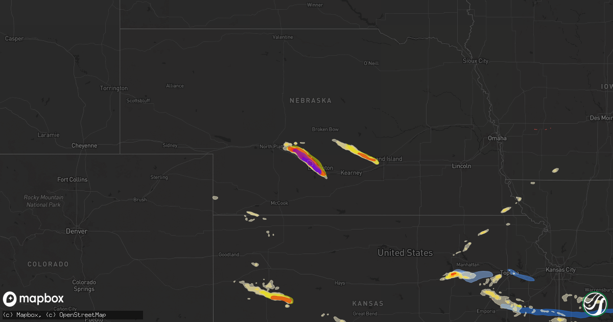
Hail Map on June 28, 2024
Get this storm
June 28 map
$229
one time, instant access
Download today. No call, no setup
Keep the $229
Bought the map and want the full workflow? Apply the entire $229 to a subscription within 7 days. None of it is wasted.
Every map, not just this one
This buys you this map. Subscription and you get every map we run, in the markets you choose from a few cities to whole states to nationwide. Plus real-time alerts the moment a storm fires.
Contact data
Name, contact info, occupancy, even credit band for addresses in the footprint. You go from where it hit to who to call.
Become the source they trust
Unlimited branding weather history reports on demand. You already have the documented answer ready for the property owner, and you are the one who showed up with it.
Property data and RoofTrace estimates
Pull up any address you have got, its value and the exact code rules for that jurisdiction, straight from One Click Code. Then RoofTrace estimates the squares, pitch, and roof value, priced the way you price.
States Impacted by Hail Map on June 28, 2024
Storm reports
Minnesota
| Date | Description |
|---|---|
| 06/28/202412:44 AM CDT | Broadcast media relayed a report from public about 8 miles east of lockhart. Golfball sized hail... Hail damage to house... And two windows blown out. |
| 06/28/202412:25 AM CDT | Facebook picture message of hail next to quarter. |
| 06/27/202411:49 PM CDT | Emergency manager reports trees down in bemidji... Power outages on the nw side of town. |
| 06/27/202411:35 PM CDT | Corrects previous tstm wnd dmg report from bemidji. Emergency manager reports trees down in bemidji... Power outages on the nw side of town. |
| 06/27/202410:20 PM CDT | Corrects previous hail report from 4 n gary. Photo of ping pong to golf ball sized hail sent via x/twitter. |
| 06/27/202410:18 PM CDT | Numerous tree limbs down and trees snapped in the neighborhood of kings dr nw... 18th ave nw... And river hill ct nw. Tree down on house. Time estimated from radar. |
| 06/27/202410:15 PM CDT | Photo of ping pong to golf ball sized hail sent via x/twitter. |
| 06/27/202410:12 PM CDT | Corrects previous hail report from lockhart. Broadcast media relayed a report from public about 8 miles east of lockhart. Golfball sized hail... Hail damage to house... |
| 06/27/20249:47 PM CDT | Corrects previous hail report from nielsville. Fire department in nielsville reports golf ball sized hail. |
| 06/27/20249:43 PM CDT | Fire department in nielsville reports golf ball sized hail. |
Florida
| Date | Description |
|---|---|
| 06/28/20242:30 PM CDT | Delayed report of a tree down across the road near olive st. Time estimated via radar. |
| 06/28/20241:46 PM CDT | Duval emergency management relayed a report of powerline wires down along the road at kernan blvd and atlantic blvd. |
| 06/28/20241:25 PM CDT | Corrects timing of event based on radar. Duval emergency management relayed a report of powerline wires down along the road at kernan blvd and atlantic blvd. |
| 06/28/20241:17 PM CDT | Photos on social media of a large tree down on powerlines at grove park blvd and catalina dr. Time estimated based on radar. |
| 06/28/20241:15 PM CDT | Updated report to change the event type to tornado. Duval county emergency management reported an overturned vehicle. Social media reports show video of the flipped veh |
| 06/28/20241:15 PM CDT | Duval county emergency management reported an overturned vehicle. Damage may be result of brief tornado in the area. |
Arizona
| Date | Description |
|---|---|
| 06/28/20246:19 PM CDT | Delayed report. Observed by personal weather station. |
| 06/28/20245:43 PM CDT | Relayed via social media. Large palo verde tree uprooted and 8 foot saguaro snapped at base. Time estimated via radar. |
| 06/28/20245:19 PM CDT | Asos station ktus tucson international airport. |
| 06/28/20243:15 PM CDT | A local report indicates 1.00 inch wind near Greasewood Springs Comm |
| 06/27/20249:00 PM CDT | Delayed report. New construction of an rv garage was destroyed. Damage blown 1/4 mile away. |
| 06/27/20249:00 PM CDT | Delayed report. Las montanas subdivision. Concrete shingle tiles torn from the side of a roof. Several concrete fence structures blown over. |
| 06/27/20249:00 PM CDT | Delayed report. Some concrete roof tiles lifted off of the lower portions of the house. Portions of block wall fencing knocked over. |
| 06/27/20248:00 PM CDT | Delayed report. Four power poles down on overfield road near battaglia drive. |
Kansas
| Date | Description |
|---|---|
| 06/28/20246:59 PM CDT | Kfri asos gusted to 66 mph. |
| 06/28/20246:54 PM CDT | Em sent photos of tree damage on grant ave. One-foot diameter trees uprooted with limbs snapped. Roof blown off structure. Time estimated from radar. Wind speed estimat |
| 06/28/20246:40 PM CDT | Trained spotter estimating 80 mph winds. 8 inch tree limbs down. |
| 06/28/20246:33 PM CDT | Spotter sent photos from monroe and 12th street. 1-2 ft diameter tree uprooted. Another 1-2 ft diameter tree with trunk snapped and fell down on house. Time estimated f |
| 06/28/20246:33 PM CDT | Spotter sent photos from cleary dr and 9th st. At two different residences... One-foot diameter tree limbs snapped and fell onto house... Causing part of the roof to ca |
| 06/28/20246:30 PM CDT | Delayed social media report that shows a small shed turned on its side. Time estimated from radar. |
| 06/28/20246:28 PM CDT | Report from mping. 1 inch tree limbs broken and shingles blown off. |
| 06/28/20246:26 PM CDT | Em also reports trees down in grandview plaza. |
| 06/28/20246:26 PM CDT | Kfri asos recorded wind gust of 64 mph. |
| 06/28/20246:21 PM CDT | Report from mping: quarter |
| 06/28/20246:20 PM CDT | Trained spotter reporting quarter to ping pong ball size hail in junction city. |
| 06/28/20246:19 PM CDT | Public report of hail between 0.5 and 1 inch. |
| 06/28/20246:17 PM CDT | Quarter to golf ball size hail. |
| 06/28/20246:08 PM CDT | Trained spotter reporting quarter sized hail. |
| 06/28/20245:48 PM CDT | Spotter estimate of 60-70 mph winds with penny size hail. |
| 06/28/20245:17 PM CDT | Up824 measured 61 mph wind gust. |
| 06/28/202412:37 AM CDT | Powerlines down. |
| 06/28/202412:30 AM CDT | Per the lane-scott electric cooperative... There were 24 broken double circuit poles along highway 4. There were also grain bins destroyed and significant crop damage a |
| 06/28/202412:20 AM CDT | A local report indicates 1.00 inch wind near Scott State Lake |
| 06/28/202412:15 AM CDT | A 6 to 8 inch diameter tree branch fell on a camper causing structural damage at scott state lake. Report via social media. |
| 06/27/202410:15 PM CDT | Report of widespread tree damage in the community of wea. |
| 06/27/202410:14 PM CDT | Mping report of 3 inch tree limbs broken; power poles broken. |
| 06/27/202410:14 PM CDT | Estimated winds of 60 mph. |
| 06/27/20249:53 PM CDT | Estimated 60 mph wind gusts in south olathe. |
| 06/27/20249:51 PM CDT | Em estimates winds of 80 mph. |
| 06/27/20249:46 PM CDT | Trained spotter reports winds around 70 mph. |
| 06/27/20249:40 PM CDT | Report from mping: half dollar |
| 06/27/20249:36 PM CDT | Em estimates winds to be 60-70 mph. |
| 06/27/20249:20 PM CDT | Estimated 60 mph wind gust north of waverly. |
| 06/27/20249:00 PM CDT | Tree limb 5 inches in diameter blown down. Winds estimated around 60 mph. |
| 06/27/20248:50 PM CDT | Em reported power line down in clinton. Time estimated by radar. |
| 06/27/20248:40 PM CDT | Chaser sent pictures of a tornado approx 8 miles s of osage city with dust swirling around the base. |
| 06/27/20248:22 PM CDT | Ktop asos gusted to 61 mph. |
| 06/27/20248:17 PM CDT | Trained spotters report tornado se of admire. |
| 06/27/20247:33 PM CDT | Delayed report. A tree around 8-12 inches in diameter was snapped. A home took siding and window damage... And a sheet metal roof was peeled back on a carport-style out |
| 06/27/20247:15 PM CDT | *** 1 inj *** khp reported a semi was blown into the median of i-70 due to strong winds. One minor injury. |
| 06/27/20247:04 PM CDT | Kfri asos gusted to 75 mph. |
Nebraska
| Date | Description |
|---|---|
| 06/28/20244:21 AM CDT | Corrects previous hail report from 5 n wood river. Nickle to quarter sized hail. Time corrected. |
| 06/28/20244:21 AM CDT | Corrects previous hail report from 5 n wood river. Corrects previous hail report from 5 n wood river. Nickle to quarter sized hail. Crops damage from hail with heaviest |
| 06/28/20244:15 AM CDT | Nickle to quarter sized hail. |
| 06/28/20244:00 AM CDT | Reports of wind damage power lines down and lots of tree damage from the storm that rolled through ravenna this morning pea to dime sized hail as well. |
| 06/28/20244:00 AM CDT | Tree branches down in parts of town with reports of some branches being 6 inches in diameter. Time est from radar. Fb report. |
| 06/28/20243:40 AM CDT | Facebook report of estimated winds at least 60 mph that knocked down several 6 to 8 inch branches. Time confirmed by security camera. |
| 06/28/20242:30 AM CDT | Quarter to golf ball sized hail fell for about 10min causing extensive crop damage. Twitter report. |
| 06/28/20242:28 AM CDT | Fb report. |
| 06/28/20242:11 AM CDT | A local report indicates 1.00 inch wind near 6 W Lexington |
| 06/28/20241:55 AM CDT | Additional photos received from the cozad area on social media showing measured 3 to 3.5 inch hailstones with others estimated as large as softballs. Significant damage |
| 06/28/20241:55 AM CDT | Numerous social media photos and reports of baseball size hail breaking windows in cozad. Time estimated from radar. |
| 06/28/20241:54 AM CDT | Via spotter network. |
| 06/28/20241:54 AM CDT | Image on social media. |
| 06/28/20241:52 AM CDT | Facebook photo of roughly 2 inch hail. Time estimated from radar and other nearby reports. |
| 06/28/20241:35 AM CDT | Social media image of several stones next to a ruler. |
| 06/28/20241:33 AM CDT | Social media photo with a ruler. |
| 06/28/20241:32 AM CDT | Social media photos of what appears to be about 2 inch hail... Possibly slightly larger. Time estimated from radar. |
| 06/28/20241:32 AM CDT | Facebook report of golf ball hail near lake helen. Time estimated from radar. |
| 06/28/20241:27 AM CDT | Nebraska mesonet site 2nw of gothenburg. Time estimated from radar. |
| 06/28/20241:10 AM CDT | Event time estimated by radar. |
North Dakota
| Date | Description |
|---|---|
| 06/27/20249:12 PM CDT | Davis 1 w of mayville reports 72 mph gust at 9:12 pm. |
| 06/27/20249:12 PM CDT | Trained spotter reports numerous trees down in mayville... Power outages... And cars under trees. Time estimated from radar. |
| 06/27/20249:12 PM CDT | Em reports trees down in mayville. No injuries thus far. Power is out... Empty grain bins are blown and blocking hwy 200. |
| 06/27/20248:35 PM CDT | Awos station ks32 cooperstown ap nd. |
| 06/27/20248:27 PM CDT | Broadcast media relayed a report of quarter sized hail in binford... Nd. |
Georgia
| Date | Description |
|---|---|
| 06/28/20242:45 PM CDT | A large tree fell on a car along providence church road. Photos were shared via social media. Time was estimated by radar. |
Iowa
| Date | Description |
|---|---|
| 06/27/20248:46 PM CDT | Brief tornado southwest of wiota. |
| 06/27/20247:58 PM CDT | Another small rope south of marne. |
| 06/27/20247:49 PM CDT | Rope tornado reported west of atlantic. |
Missouri
| Date | Description |
|---|---|
| 06/27/202410:43 PM CDT | Tree limbs downed in harrisonville. |
| 06/27/202410:35 PM CDT | Tree limbs downed south of freeman. |
| 06/27/202410:33 PM CDT | Power lines downed near west line. |
| 06/27/202410:26 PM CDT | Estimated 60 mph wind gusts in cleveland. |
| 06/27/20249:02 PM CDT | Multiple reports of a tornado near the missouri river northwest of corning. Radar imagery paired with various photos and videos suggests it was about one mile east of t |
Cities Impacted by Hail Map on June 28, 2024
- Hialeah, FL
- Miami, FL
- Opa Locka, FL
- Hollywood, FL
- Jacksonville, FL
- Winslow, AZ
- Ganado, AZ
- Indiantown, FL
- Okeechobee, FL
- Chapman, KS
- Enterprise, KS
- Abilene, KS
- Rifle, CO
- Meeker, CO
- Junction City, KS
- Enning, SD
- Tombstone, AZ
- Wall, SD
- Steamboat Springs, CO
- Fort Riley, KS
- Riley, KS
- Manhattan, KS
- Alta Vista, KS
- Dwight, KS
- Alma, KS
- Leonardville, KS
- Milesville, SD
- Randolph, KS
- Olsburg, KS
- Bismarck, ND
- Eskridge, KS
- McFarland, KS
- Paxico, KS
- Westmoreland, KS
- Frankfort, KS
- Vermillion, KS
- Centralia, KS
- Maple Hill, KS
- Allen, KS
- Seneca, KS
- Haigler, NE
- Admire, KS
- Mchenry, ND
- Reading, KS
- Atlantic, IA
- Topeka, KS
- Harveyville, KS
- Auburn, KS
- Fairview, KS
- Sabetha, KS
- Osage City, KS
- Binford, ND
- Dawson, NE
- Salem, NE
- Hiawatha, KS
- Tecumseh, KS
- Grantville, KS
- Lecompton, KS
- Cooperstown, ND
- Jessie, ND
- Sharon, ND
- Verdon, NE
- Rock Port, MO
- Fairfax, MO
- Lawrence, KS
- Aneta, ND
- Stratton, NE
- Lyndon, KS
- Finley, ND
- De Beque, CO
- Falls City, NE
- Craig, MO
- Eudora, KS
- Lebo, KS
- Portland, ND
- Hatton, ND
- Parachute, CO
- Elmo, MO
- Westboro, MO
- Melvern, KS
- Hope, ND
- Luverne, ND
- Mayville, ND
- Clifford, ND
- Blanchard, ND
- Waverly, KS
- Atwood, KS
- Buxton, ND
- Cummings, ND
- Hillsboro, ND
- Caledonia, ND
- Climax, MN
- Nielsville, MN
- Shelly, MN
- Williamsburg, KS
- Garnett, KS
- Herndon, KS
- Quenemo, KS
- Pomona, KS
- Princeton, KS
- Richmond, KS
- Ada, MN
- Beltrami, MN
- Gravity, IA
- Bedford, IA
- Halstad, MN
- McDonald, KS
- Fertile, MN
- Gary, MN
- Greeley, KS
- Lane, KS
- Parker, KS
- Bejou, MN
- Winger, MN
- Osawatomie, KS
- Fontana, KS
- Ottawa, KS
- Cleveland, MO
- Freeman, MO
- Burlingame, KS
- Drexel, MO
- Harrisonville, MO
- Peculiar, MO
- Archie, MO
- Mahnomen, MN
- Westphalia, KS
- Lengby, MN
- Bagley, MN
- Garden City, MO
- Creighton, MO
- Wallace, KS
- Holden, MO
- Shevlin, MN
- Winona, KS
- La Cygne, KS
- Butler, MO
- Blairstown, MO
- Paola, KS
- Amsterdam, MO
- Adrian, MO
- Montrose, MO
- Urich, MO
- Clinton, MO
- Bemidji, MN
- Leeton, MO
- Chilhowee, MO
- Rantoul, KS
- Scott City, KS
- Windsor, MO
- Calhoun, MO
- Lincoln, MO
- Cole Camp, MO
- Oakley, KS
- Pleasanton, KS
- Mound City, KS
- Healy, KS
- Deer River, MN
- Amoret, MO
- Foster, MO
- Pekin, ND
- Bena, MN
- Grinnell, KS
- Cass Lake, MN
- Blackduck, MN
- Pennington, MN
- Marcell, MN
- Brady, NE
- Maxwell, NE
- Gothenburg, NE
- Dighton, KS
- Grover, CO
- Cozad, NE
- Willow Island, NE
- Lexington, NE
- Elwood, NE
- Colby, KS
- Leoti, KS
- Bertrand, NE
- Smithfield, NE
- Appleton City, MO
- Rockville, MO
- Mason City, NE
- Ansley, NE
- Oconto, NE
- Litchfield, NE
- Hazard, NE
- Ravenna, NE
- Hume, MO
- Rich Hill, MO
- Pleasanton, NE
- Cairo, NE
- Richards, MO
- Shelton, NE
- Wood River, NE
- Alda, NE
- Schell City, MO
- Ness City, KS
- Burdett, KS
- Rozel, KS
- Larned, KS
- Newman, IL
- Hume, IL
- Oakland, IL
- Callaway, NE