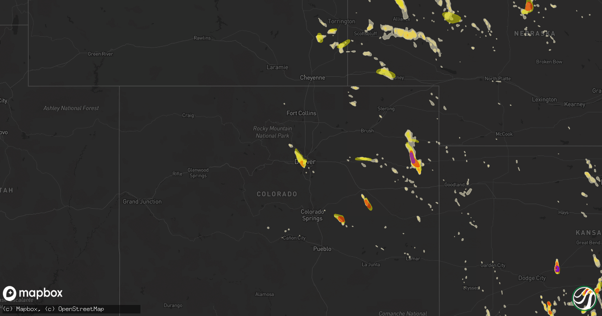
Hail Map on June 28, 2016
Get this storm
June 28 map
$229
one time, instant access
Download today. No call, no setup
Keep the $229
Bought the map and want the full workflow? Apply the entire $229 to a subscription within 7 days. None of it is wasted.
Every map, not just this one
This buys you this map. Subscription and you get every map we run, in the markets you choose from a few cities to whole states to nationwide. Plus real-time alerts the moment a storm fires.
Contact data
Name, contact info, occupancy, even credit band for addresses in the footprint. You go from where it hit to who to call.
Become the source they trust
Unlimited branding weather history reports on demand. You already have the documented answer ready for the property owner, and you are the one who showed up with it.
Property data and RoofTrace estimates
Pull up any address you have got, its value and the exact code rules for that jurisdiction, straight from One Click Code. Then RoofTrace estimates the squares, pitch, and roof value, priced the way you price.
States Impacted by Hail Map on June 28, 2016
Storm reports
Wyoming
| Date | Description |
|---|---|
| 06/28/20166:27 PM CDT | A local report indicates 60 MPH wind near TORRINGTON |
| 06/28/20166:09 PM CDT | A local report indicates 1.00 inch wind near YODER |
| 06/28/20165:33 PM CDT | A local report indicates 1.00 inch wind near BILL |
| 06/28/20164:43 PM CDT | A local report indicates 60 MPH wind near GLENROCK |
| 06/28/20164:41 PM CDT | Sustained 47 mph. |
| 06/28/20163:53 PM CDT | A local report indicates 1.00 inch wind near 8 S UPTON |
| 06/28/20163:40 PM CDT | 50 mph wnd gusts |
| 06/28/20163:05 PM CDT | 2 se hiland /khld/. |
| 06/28/20162:47 PM CDT | A local report indicates 1.00 inch wind near 5 E DOWNTOWN GILLETTE |
| 06/28/20162:36 PM CDT | A local report indicates 1.50 inch wind near 5 SE DOWNTOWN GILLETTE |
| 06/28/20162:36 PM CDT | A local report indicates 60 MPH wind near DOWNTOWN GILLETTE |
Maryland
| Date | Description |
|---|---|
| 06/28/20166:45 PM CDT | Numerous trees and wires down on baptist church road near nanjemoy. |
| 06/28/20166:01 PM CDT | Roof of parking garage damaged by high winds. |
| 06/28/20165:59 PM CDT | 53-knot wind gust measured at francis scott key middle school. |
| 06/28/20165:57 PM CDT | Tree down in yard in four corners section of silver spring. |
| 06/28/20165:52 PM CDT | Several trees down and power out in white oak. |
| 06/28/20165:36 PM CDT | Couple of 2 to 3 inch tree limbs down |
| 06/28/20165:23 PM CDT | Tree down on glenhannah rd |
| 06/28/20165:23 PM CDT | Tree down behind house on nicky ct |
| 06/28/20165:21 PM CDT | Tree down in yard near gorman park. |
| 06/28/20165:16 PM CDT | Large 5 inch tree limb down |
| 06/28/20165:05 PM CDT | Tree down near the intersection of little patuxent parkway and governor warfield parkway. |
| 06/28/20165:04 PM CDT | Large branch down on luckpenny rd |
| 06/28/20165:00 PM CDT | Tree down in the 5400 block of luckpenny place. |
| 06/28/20163:26 PM CDT | Tree down in new windsor |
| 06/28/20162:59 PM CDT | Tree down at wolfsville rd and meeting house rd |
| 06/28/20162:55 PM CDT | Tree down in myersville |
South Dakota
| Date | Description |
|---|---|
| 06/28/20166:34 PM CDT | A local report indicates 1.25 inch wind near 7 SSW PLAINVIEW |
| 06/28/20166:15 PM CDT | A local report indicates 65 MPH wind near 4 WNW SLIM BUTTE |
| 06/28/20166:14 PM CDT | A local report indicates 1.75 inch wind near 7 SSW BILLSBURG |
| 06/28/20165:59 PM CDT | A local report indicates 63 MPH wind near 12 E OELRICHS |
| 06/28/20165:56 PM CDT | A local report indicates 1.00 inch wind near 8 SSW UNION CENTER |
| 06/28/20165:55 PM CDT | Hail lasted 20 minutes |
| 06/28/20165:48 PM CDT | A local report indicates 60 MPH wind near OELRICHS |
| 06/28/20165:42 PM CDT | A local report indicates 1.50 inch wind near 8 NE SCENIC |
| 06/28/20165:40 PM CDT | A local report indicates 66 MPH wind near 2 SSW ORAL |
| 06/28/20165:32 PM CDT | A local report indicates 1.00 inch wind near 10 ESE CREIGHTON |
| 06/28/20165:30 PM CDT | Entire tree snapped in half from thunderstorm winds |
| 06/28/20165:24 PM CDT | A local report indicates 62 MPH wind near DOWNTOWN HOT SPRINGS |
| 06/28/20165:24 PM CDT | A local report indicates 1.00 inch wind near ANGOSTURA RESERVOIR |
| 06/28/20165:21 PM CDT | A local report indicates 1.00 inch wind near 6 WNW ANGOSTURA RESERVO |
| 06/28/20165:19 PM CDT | Lasted about 10 minutes |
| 06/28/20165:14 PM CDT | A local report indicates 74 MPH wind near 1 W WIND CAVE VISITORS |
| 06/28/20165:06 PM CDT | A local report indicates 1.00 inch wind near 4 W DOWNTOWN HOT SPRING |
| 06/28/20164:53 PM CDT | A local report indicates 65 MPH wind near 6 E NEW UNDERWOOD |
| 06/28/20164:53 PM CDT | A local report indicates 2.00 inch wind near 6 E NEW UNDERWOOD |
| 06/28/20164:52 PM CDT | At beaver lake campground |
| 06/28/20164:48 PM CDT | Pine tree snapped in half . Time approximated by radar. |
| 06/28/20164:25 PM CDT | A local report indicates 1.75 inch wind near 8 WSW HILL CITY |
| 06/28/20164:18 PM CDT | A local report indicates 1.00 inch wind near 8 WSW HILL CITY |
Idaho
| Date | Description |
|---|---|
| 06/28/20165:48 PM CDT | Time estimated from radar |
Nebraska
| Date | Description |
|---|---|
| 06/28/20166:43 PM CDT | Estimated wind speeds of between 60 and 70 mph |
| 06/28/20166:23 PM CDT | A local report indicates 58 MPH wind near 4 SE ALLIANCE |
| 06/28/20166:22 PM CDT | King canyon raws |
| 06/28/20166:16 PM CDT | A local report indicates 60 MPH wind near CHADRON |
| 06/28/20166:16 PM CDT | Tree branches have snapped off and fallen over. Power lines are also down in the city. |
| 06/28/20166:16 PM CDT | A local report indicates 1.00 inch wind near 8 NNW GORDON |
| 06/28/20166:14 PM CDT | 73 knot gust. |
| 06/28/20166:07 PM CDT | 73 knot gust. |
| 06/28/20166:00 PM CDT | Estimated 60 mph wind gust... Tree branches down and powerline knocked out. |
| 06/28/20166:00 PM CDT | Also receiving pea to dime size hail |
| 06/27/201611:03 PM CDT | A local report indicates 58 MPH wind near MCCOOK |
| 06/27/201610:40 PM CDT | Winds estimated at 60 mph. Tree limbs down and power out in sargent from 1040 until around midnight. |
| 06/27/201610:33 PM CDT | A local report indicates 62 MPH wind near HAYES CENTER |
| 06/27/201610:30 PM CDT | Trees and powerlines down across the county. Some located in benkelman but damage sounded widespread. Time of arrival in benkelman estimated by radar. |
| 06/27/201610:21 PM CDT | Trees down in parks. Social media report. Time estimated by radar. |
| 06/27/201610:20 PM CDT | Large tree branches up to 3 inches in diameter down. Time estimated from radar. Social media report. |
| 06/27/201610:15 PM CDT | Two large trees uprooted in champion. Winds estimated at 70 mph. Delayed report from broadcast media. |
| 06/27/201610:13 PM CDT | Site is near the intersection of cr 721 and avenue 339. |
| 06/27/201610:10 PM CDT | Estimated 50 to 60 mph winds. |
| 06/27/201610:05 PM CDT | At least 60 mph winds estimated. |
| 06/27/201610:01 PM CDT | A local report indicates 78 MPH wind near 10 N NORTH PLATTE |
| 06/27/20169:58 PM CDT | A local report indicates 70 MPH wind near 10 SSW STAPLETON |
| 06/27/20169:54 PM CDT | A local report indicates 77 MPH wind near ELSIE |
| 06/27/20169:52 PM CDT | A local report indicates 70 MPH wind near 10 N NORTH PLATTE |
| 06/27/20169:40 PM CDT | A local report indicates 59 MPH wind near 4 NE HERSHEY |
| 06/27/20169:35 PM CDT | Estimated time of 935 pm cdt with 60 to 70 mph winds with estimated 1 inch rainfall. |
| 06/27/20169:15 PM CDT | Numerous powerlines downed... Tree limbs 6 inches in diameter downed... And windows at the to haas tire shop blown out-no injuries. Time estimated from awos. |
| 06/27/20169:15 PM CDT | A local report indicates 78 MPH wind near OGALLALA |
| 06/27/20169:15 PM CDT | Union pacific |
| 06/27/20169:15 PM CDT | Multiple accidents on i80 across deuel county relayed via fire department from big springs. |
| 06/27/20169:15 PM CDT | Union pacific |
| 06/27/20169:14 PM CDT | A local report indicates 60 MPH wind near 8 NNE KINGSLEY DAM |
| 06/27/20169:14 PM CDT | Raws site |
| 06/27/20169:10 PM CDT | Hail was soft and breaking on impact with the ground. Most hail sizes were nickel... But assumed to be quarters. |
| 06/27/20169:10 PM CDT | Numerous 4 to 6 inch diameter limbs down |
| 06/27/20169:09 PM CDT | A local report indicates 60 MPH wind near 1 WSW KINGSLEY DAM |
| 06/27/20169:07 PM CDT | A local report indicates 60 MPH wind near 4 WSW BIG SPRINGS |
| 06/27/20168:58 PM CDT | A local report indicates 62 MPH wind near CRESCENT LAKE NWR |
| 06/27/20168:50 PM CDT | Semi blow over near exit 95 on interstate 80 |
| 06/27/20168:50 PM CDT | Power pole and lines blown down in big springs |
| 06/27/20168:45 PM CDT | 745 mdt a 50 to 60 foot russian olive tree fell over near clear creek wildlife refugee. Also reported several 6 inch diameter branches down... Branches knocked power li |
| 06/27/20168:40 PM CDT | Winds were estimated at 75 mph. |
| 06/27/20168:39 PM CDT | A local report indicates 1.00 inch wind near 14 S JOHNSTOWN |
| 06/27/20168:38 PM CDT | Report via facebook. |
| 06/27/20168:30 PM CDT | A local report indicates 58 MPH wind near 1 N SIDNEY |
| 06/27/20168:30 PM CDT | A local report indicates 60 MPH wind near SIDNEY |
| 06/27/20168:25 PM CDT | Some tree damage at residence. Large hay bails blown down the field. |
| 06/27/20168:15 PM CDT | Union pacific |
| 06/27/20168:15 PM CDT | A local report indicates 60 MPH wind near 1 SE MERRITT RESERVOIR |
| 06/27/20168:10 PM CDT | A local report indicates 70 MPH wind near 5 W HYANNIS |
| 06/27/20168:07 PM CDT | 70 mph wind driven hail |
| 06/27/20168:07 PM CDT | In addition to strong winds...hail to the size of quarters also fell. |
| 06/27/20167:51 PM CDT | Trees down. |
| 06/27/20167:50 PM CDT | A local report indicates 66 MPH wind near IMPERIAL |
| 06/27/20167:50 PM CDT | Tree branches down on the roads. |
| 06/27/20167:45 PM CDT | Bridgeport upr sensor |
| 06/27/20167:34 PM CDT | Shingles torn off the roof of the residents. |
| 06/27/20167:34 PM CDT | Visible 15 to 20 miles north of ashby. Report relayed by dispatch. |
| 06/27/20167:32 PM CDT | Fire department reports a tornado north of hyannis |
| 06/27/20167:32 PM CDT | Fire department reports a tornado north of ashby |
| 06/27/20167:30 PM CDT | Roof damage. Hay bales destroyed. Tree branches down. Time estimated. Home owner returned home to find the damage. |
| 06/27/20167:23 PM CDT | 56 knot gust. |
| 06/27/20167:15 PM CDT | A local report indicates 60 MPH wind near 17 WNW HEMINGFORD |
| 06/27/20167:13 PM CDT | Raws site. |
| 06/27/20167:05 PM CDT | Winds were estimated between 60 to 70 mph. |
| 06/27/20167:00 PM CDT | Estimated 60 mph wind gust... Tree branches down and powerline knocked out. |
New Jersey
| Date | Description |
|---|---|
| 06/28/20166:17 PM CDT | A local report indicates 1.00 inch wind near PLEASANT VALLEY |
| 06/27/20168:30 PM CDT | Car flipped onto its roof on central avenue. Multiple trees down and minor structural damage on central avenue near south street and livingston avenue. |
| 06/27/20168:11 PM CDT | Large tree knocked down onto i-287 near mile marker 30. |
| 06/27/20168:00 PM CDT | Trees down. Also in bernardsville. |
Arizona
| Date | Description |
|---|---|
| 06/28/20165:29 PM CDT | A local report indicates 59 MPH wind near PAGE AIRPORT |
Kansas
| Date | Description |
|---|---|
| 06/28/20164:20 PM CDT | . |
| 06/28/20164:10 PM CDT | . |
| 06/28/20163:58 PM CDT | . |
| 06/28/20163:57 PM CDT | . |
| 06/28/20163:49 PM CDT | Some damage to siding on home also reported. |
| 06/28/20163:26 PM CDT | A local report indicates 1.00 inch wind near 1 SE CAIRO |
| 06/28/20163:04 PM CDT | Measured 3.5 inches. |
| 06/28/20163:00 PM CDT | From social media. Estimated from radar. |
| 06/28/20162:58 PM CDT | Mostly nickels... A few quarters. |
| 06/28/20162:56 PM CDT | . |
| 06/28/20162:50 PM CDT | . |
| 06/28/20164:15 AM CDT | In addition... Winds were estimated to be 60 to 70 mph. |
| 06/28/20164:15 AM CDT | Winds were estimated to be 60 to 70 mph. There was also quarter sized hail. |
| 06/28/20162:50 AM CDT | Mesonet station 1 nw ulysses /kuls/. |
| 06/28/20162:33 AM CDT | Asos station garden city regional airport /gck/. |
| 06/28/20161:55 AM CDT | Awos station syracuse /3k3/. |
| 06/28/20161:31 AM CDT | . |
| 06/28/201612:35 AM CDT | A local report indicates 60 MPH wind near OAKLEY |
| 06/27/201611:19 PM CDT | A local report indicates 61 MPH wind near ATWOOD |
| 06/27/201611:15 PM CDT | Large tree down in atwood. Social media poster was unsure if this was related to the 60 mph winds or due to a lightning strike. |
| 06/27/201611:13 PM CDT | A local report indicates 58 MPH wind near ATWOOD |
| 06/27/201610:51 PM CDT | A local report indicates 63 MPH wind near 9 WNW ST. FRANCIS |
| 06/27/201610:51 PM CDT | A local report indicates 68 MPH wind near ST. FRANCIS |
| 06/27/201610:47 PM CDT | A local report indicates 59 MPH wind near ST. FRANCIS |
| 06/27/201610:41 PM CDT | 1.5 miles east of county road w and 15 intersection. |
Georgia
| Date | Description |
|---|---|
| 06/28/20164:00 PM CDT | Several trees reported down near pleasant grove road. |
| 06/28/20163:48 PM CDT | Six trees down in the southern portion of hancock county near hwy 16 west and hwy 22 east. |
| 06/28/20163:18 PM CDT | One tree downed across liberty church road in southern greene county. |
| 06/28/20163:15 PM CDT | Several trees reported down along state road 44 in northern part of county. |
| 06/27/20168:22 PM CDT | Tree reported down on johnny mercer blvd near turners rock rd. Time estimated based on radar. |
| 06/27/20168:10 PM CDT | Savannah broadcast media relayed a report of a tree down on burbank boulevard. |
| 06/27/20168:06 PM CDT | Emergency manager reported multiple trees down and over a dozen large branches within oatland island wildlife center. Time estimated based on radar. |
| 06/27/20168:06 PM CDT | Tree reported down on river dr at tuberson ave. Time estimated based on radar. |
| 06/27/20168:04 PM CDT | Tree reported down at the intersection of pennsylvania ave and tennessee st. Time estimated based on radar. |
| 06/27/20168:01 PM CDT | Tree reported down near the 2300 block of new mexico st. Time estimated based on radar. |
Virginia
| Date | Description |
|---|---|
| 06/28/20166:55 PM CDT | Tree down at courthouse rd and shelton shop rd |
| 06/28/20166:32 PM CDT | Multiple trees down near the intersection of garrisonville road and shelton shop road. |
| 06/28/20166:06 PM CDT | Tree down on power line on ohio ave |
| 06/28/20166:00 PM CDT | Trees down along route 627. A few trees on roofs. |
| 06/28/20165:54 PM CDT | Tree down at the intersection of admiral drive and lighthouse lane. |
| 06/28/20165:47 PM CDT | Tree down on 4100 block of laurel road |
| 06/28/20165:44 PM CDT | Several small branches down |
| 06/28/20165:40 PM CDT | Tree down near the intersection of old bridge road and mohican road. |
| 06/28/20165:38 PM CDT | Tree down near the intersection of hedges run drive and cornice place. |
| 06/28/20165:17 PM CDT | 2 trees snapped many limbs down |
| 06/28/20165:14 PM CDT | Tree on power line on keith rd and stewart st |
| 06/28/20165:14 PM CDT | 2 trees snapped many limbs down |
| 06/28/20165:14 PM CDT | Tree limb down on power lines near main street and portner avenue. |
| 06/28/20164:49 PM CDT | Multiple trees down on devlin road. |
| 06/28/20164:15 PM CDT | Numerous trees down in the 5200 block of hopewell road. |
| 06/28/20164:13 PM CDT | Multiple trees down near the intersection of halfway road and landmark road. |
| 06/28/20164:10 PM CDT | Tree down near the intersection of buck mountain road and browntown road. |
| 06/28/20164:05 PM CDT | Multiple trees down near the intersection of zulla road and muster lane. |
| 06/28/20163:51 PM CDT | Multiple trees down on route 50 |
| 06/28/20163:47 PM CDT | Tree down on dam town road near river bend drive. |
| 06/28/20163:44 PM CDT | Tree down on toll gate road near lee highway. |
| 06/27/20168:53 PM CDT | Tree down at the intersection of potomac landing drive and marineview road. |
| 06/27/20168:31 PM CDT | Wires down near the intersection of powhatan street and college avenue. |
| 06/27/20168:13 PM CDT | Tree down on spring branch boulevard near hollyside drive. |
| 06/27/20168:03 PM CDT | Tree down in the 12400 block of tower hill road. |
| 06/27/20167:58 PM CDT | Tree down in the 12600 block of elk run road. |
| 06/27/20167:11 PM CDT | Tree down near the intersection of owens drive and mathias point road. |
New York
| Date | Description |
|---|---|
| 06/28/20166:38 PM CDT | Nickel to quarter size hail at the helena general store |
| 06/28/20166:25 PM CDT | A local report indicates 1.00 inch wind near MASSENA |
| 06/28/20166:22 PM CDT | Reported from the public. |
| 06/28/20165:49 PM CDT | Trees and power lines down. |
| 06/28/20164:48 PM CDT | Trees down on county rt 27 near trout creek |
| 06/28/20164:05 PM CDT | Quarter to half dollar sized hail... 1.56 inches rain past hour |
| 06/28/20162:14 PM CDT | Powerlines wires down |
| 06/28/20161:08 PM CDT | Trained spotter |
| 06/28/20161:05 PM CDT | Trained spotter |
| 06/28/20161:05 PM CDT | Trees and wires down route 5s and dyke road |
| 06/28/201612:30 PM CDT | Several trees down in the town of clinton |
| 06/28/201612:20 PM CDT | A local report indicates 1.25 inch wind near 3 NW HARKNESS |
| 06/28/201612:15 PM CDT | A local report indicates 1.00 inch wind near ENDICOTT |
Montana
| Date | Description |
|---|---|
| 06/28/20166:55 PM CDT | A local report indicates 1.75 inch wind near 4 W EKALAKA |
| 06/28/20166:47 PM CDT | Trained spotter reported quarter sized hail. |
Oklahoma
| Date | Description |
|---|---|
| 06/28/20166:42 PM CDT | A local report indicates 1.75 inch wind near 2 W WATONGA |
| 06/28/20166:35 PM CDT | A local report indicates 60 MPH wind near 2 W WATONGA |
| 06/28/20166:25 PM CDT | A local report indicates 61 MPH wind near 3 N PUTNAM |
| 06/28/20166:15 PM CDT | Roof of house partially blown off. |
| 06/28/20166:15 PM CDT | A local report indicates 68 MPH wind near 1 W FAIRVIEW |
| 06/28/20166:00 PM CDT | A local report indicates 64 MPH wind near 7 WNW SEILING |
| 06/28/20165:55 PM CDT | A local report indicates 61 MPH wind near 7 WNW SEILING |
| 06/28/20165:50 PM CDT | Several tree limbs blown down. |
| 06/28/20165:42 PM CDT | Spotter reports large tree limbs down... Resulting in minor damage to pickup truck. |
| 06/28/20165:30 PM CDT | Several large tree limbs downed by winds estimated between 60 and 70 mph. |
| 06/28/20165:05 PM CDT | A local report indicates 61 MPH wind near 7 SSW ALVA |
| 06/28/20164:45 PM CDT | A few quarters observed |
| 06/27/201610:00 PM CDT | A local report indicates 59 MPH wind near 4 S TIPTON |
| 06/27/20169:33 PM CDT | A local report indicates 58 MPH wind near FREDERICK |
| 06/27/20169:20 PM CDT | A local report indicates 60 MPH wind near INDIAHOMA |
| 06/27/20168:55 PM CDT | Kaxs awos |
| 06/27/20168:49 PM CDT | Kaxs awos |
| 06/27/20168:43 PM CDT | A local report indicates 64 MPH wind near ALTUS AIR FORCE BASE |
| 06/27/20168:15 PM CDT | A local report indicates 65 MPH wind near CLINTON |
| 06/27/20168:13 PM CDT | Minor roof damage reported to several homes... Shingles missing. |
| 06/27/20168:02 PM CDT | A local report indicates 60 MPH wind near 5 W ALBERT |
| 06/27/20168:02 PM CDT | A local report indicates 58 MPH wind near 3 SE HOBART |
| 06/27/20167:35 PM CDT | A local report indicates 61 MPH wind near WEATHERFORD |
| 06/27/20167:21 PM CDT | Csm asos |
| 06/27/20167:20 PM CDT | A local report indicates 70 MPH wind near 4 WSW WEATHERFORD |
| 06/27/20167:20 PM CDT | A local report indicates 62 MPH wind near 4 WNW BESSIE |
| 06/27/20167:20 PM CDT | Kwtv channel 9 spotter reports tractor trailer blown over on i-40 near weatherford. Time estimated by radar. |
| 06/27/20167:18 PM CDT | A local report indicates 60 MPH wind near WEATHERFORD |
| 06/27/20167:18 PM CDT | 6 inch tree branches down. Fences down. |
| 06/27/20167:00 PM CDT | Kwtv channel 9 showed damage to a marina and boats at foss reservoir. Time estimated by radar. |
Pennsylvania
| Date | Description |
|---|---|
| 06/28/20163:55 PM CDT | Twitter photo emigsville/roundtown |
| 06/28/20163:55 PM CDT | Trees/wires down nrn part of york/manchester twp |
| 06/28/20163:25 PM CDT | Trees down on wires near sunbury. |
| 06/28/20163:24 PM CDT | Several large tree limbs down on black swamp rd |
| 06/28/20163:00 PM CDT | Multiple trees down via police scanner |
| 06/28/20162:50 PM CDT | Tree fell on truck... Other trees down |
| 06/28/20162:49 PM CDT | Damaged chicken coop. |
| 06/28/20162:25 PM CDT | Trees down along rt 54 |
| 06/28/20162:10 PM CDT | Trees down wheatfield twp |
| 06/28/20162:00 PM CDT | Numerous trees down/half inch hail |
| 06/28/20161:50 PM CDT | Trees/wires down colorado st guilford twp |
| 06/28/20161:28 PM CDT | Nickel to quarter size hail reported near centre hall. |
Texas
| Date | Description |
|---|---|
| 06/28/20163:52 PM CDT | Estimated 4-5 inch diameter limb broken off tree |
| 06/27/20169:45 PM CDT | A local report indicates 60 MPH wind near 3 E OKLAUNION |
| 06/27/20169:27 PM CDT | A local report indicates 60 MPH wind near 3 N CHILLICOTHE |
Missouri
| Date | Description |
|---|---|
| 06/28/20163:52 PM CDT | A few trees and powerlines down in the city of clarkton. Time is radar estimated. |
South Carolina
| Date | Description |
|---|---|
| 06/28/20165:02 PM CDT | Tree reported down on first street east near the intersection with holly street east. |
| 06/28/20164:49 PM CDT | Tree reported down on joe miley rd at the intersection with sandy run rd. Time estimated based on radar. |
| 06/28/20164:17 PM CDT | Tree reported down across the road near the 3000 block of coolers dairy road. Time estimated based on radar. |
| 06/27/20167:42 PM CDT | Tree reported down on us-17 near the intersection with sc-315. Time estimated based on radar. |
West Virginia
| Date | Description |
|---|---|
| 06/28/20162:30 PM CDT | Multiple trees down on woodbrier golf course |
Maine
| Date | Description |
|---|---|
| 06/28/20161:02 PM CDT | 5 inch diameter tree into power lines between ashland and presque isle me on rte 163. |
| 06/28/201612:58 PM CDT | Nine full sized trees snapped in a very localized area. |
Colorado
| Date | Description |
|---|---|
| 06/27/201611:35 PM CDT | . |
| 06/27/201611:15 PM CDT | . |
| 06/27/201610:50 PM CDT | Hail lasted 25 minutes. Minor leaf damage... Shredded leaves... Car dents. |
| 06/27/201610:45 PM CDT | Leanto was blown over. Radar was used to approximate the time. |
| 06/27/201610:22 PM CDT | Also nickel size hail and 3 to 5 inch diameter tree limbs down. |
| 06/27/20169:55 PM CDT | A local report indicates 65 MPH wind near 7 NNW ALVIN |
| 06/27/20169:30 PM CDT | Windows to vehicle shattered. All windows on the north side of the residence were destroyed. |
| 06/27/20169:27 PM CDT | Up to quarter sized hail |
| 06/27/20169:08 PM CDT | A local report indicates 1.00 inch wind near 4 NW LAST CHANCE |
| 06/27/20168:58 PM CDT | A local report indicates 1.00 inch wind near 7 NW LAST CHANCE |
| 06/27/20167:34 PM CDT | A local report indicates 1.00 inch wind near 5 NNW AURORA |
| 06/27/20167:33 PM CDT | A local report indicates 1.50 inch wind near 2 NW SHERIDAN |
| 06/27/20167:31 PM CDT | A local report indicates 1.00 inch wind near 4 W DENVER |
| 06/27/20167:18 PM CDT | A local report indicates 1.00 inch wind near 5 NW DENVER |
Tennessee
| Date | Description |
|---|---|
| 06/28/20165:40 PM CDT | A tree took out a power line and clipped the corner of a house on timberside drive. |
| 06/28/20165:20 PM CDT | *** 1 inj *** a large tree fell onto a car on waikiki blvd at richards road in antioch. One woman in the vehicle reportedly suffered minor injuries. |
| 06/28/20165:18 PM CDT | Large tree uprooted onto a house in the hillbrook area |
| 06/28/20165:17 PM CDT | A few trees down in the antioch area. |
| 06/28/20165:11 PM CDT | Shingles blown off the roof of a home in east nashville |
| 06/28/20165:05 PM CDT | Several twitter reports of trees down in inglewood area |
| 06/28/20165:03 PM CDT | Large tree limbs down and power outages across inglewood area |
| 06/28/20164:59 PM CDT | Large tree down in front yard of home at 912 curdwood blvd in inglewood |
| 06/28/20164:55 PM CDT | Two trees down across bellevue road near wildwood place in bellevue. Time estimated. |
| 06/28/20164:20 PM CDT | 100 year old oak tree blown down in cumberland furnace |
| 06/28/20163:35 PM CDT | Power pole and tree branches down on madison street in clarksville |
| 06/28/20163:30 PM CDT | Large tree down in backyard of home in clarksville |
Nevada
| Date | Description |
|---|---|
| 06/27/20168:45 PM CDT | Glass table tossed into pool. 3 adult palm trees damaged... One snapped near the base due to high winds. Time estimated and compared to strongest winds near vgt. |
| 06/27/20168:00 PM CDT | Outdoor gazebo destroyed by strong winds. Report via photo on social media. |
Cities Impacted by Hail Map on June 28, 2016
- Coats, KS
- Upton, WY
- Gillette, WY
- Ralston, PA
- Arnett, OK
- Kinsley, KS
- Offerle, KS
- Flagler, CO
- Cope, CO
- Pringle, SD
- Custer, SD
- Hill City, SD
- Rozet, WY
- Cranfills Gap, TX
- Pocahontas, AR
- Midland, SD
- Sharon, KS
- Medicine Lodge, KS
- Ashby, NE
- Merriman, NE
- Muncy, PA
- Turbotville, PA
- Bloomsburg, PA
- Millville, PA
- Danville, PA
- Salado, TX
- Lance Creek, WY
- Lewellen, NE
- Oshkosh, NE
- Red Lodge, MT
- Laverne, OK
- Easton, MO
- Chadron, NE
- Oelrichs, SD
- Pine Ridge, SD
- Hay Springs, NE
- Smithwick, SD
- Hot Springs, SD
- Edgemont, SD
- Cut Bank, MT
- Alliance, NE
- Hemingford, NE
- Penrose, CO
- Corn, OK
- Weatherford, OK
- Lone Wolf, OK
- Howes, SD
- West Forks, ME
- Jackman, ME
- Yuma, CO
- Ainsworth, NE
- Sharon, OK
- Lockwood, NY
- Barton, NY
- Chemung, NY
- Waverly, NY
- Lowman, NY
- Elmira, NY
- Yoder, WY
- Burke, NY
- Crookston, NE
- Valentine, NE
- Cody, NE
- Kilgore, NE
- Peru, NY
- York, PA
- Dover, PA
- Vona, CO
- Sawyer, KS
- Walton, NY
- Deposit, NY
- New Bloomfield, PA
- Duncannon, PA
- Alva, OK
- Chugwater, WY
- Wheatland, WY
- Hawk Springs, WY
- Greensboro, GA
- Eatonton, GA
- New Underwood, SD
- Grosse Tete, LA
- Marysville, PA
- Shermans Dale, PA
- Mullen, NE
- Lookeba, OK
- Mullin, TX
- Fort Benton, MT
- Chester, MT
- Ledger, MT
- Canadian, TX
- Hamilton, TX
- Smithland, KY
- Brookport, IL
- Merino, CO
- Morgan, TX
- Clifton, TX
- Meridian, TX
- Ashland, KS
- Minneola, KS
- Milton, PA
- McEwensville, PA
- Watsontown, PA
- Dunning, NE
- Purdum, NE
- Woodward, OK
- Pineville, SC
- Protection, KS
- Forksville, PA
- Shunk, PA
- Fort Worth, TX
- Burleson, TX
- Reva, SD
- Buffalo, SD
- Atwood, KS
- Johnstown, NE
- Elsmere, NE
- Cheneyville, LA
- Bunkie, LA
- Rosston, OK
- Quantico, VA
- Nokesville, VA
- Manassas, VA
- Catlett, VA
- Hico, TX
- Sturgis, SD
- White Owl, SD
- Wall, SD
- Enning, SD
- Union Center, SD
- Wasta, SD
- Crowell, TX
- Flagstaff, AZ
- Seguin, TX
- Kingsbury, TX
- Lexington, TX
- Sargent, NE
- Taylor, NE
- Wray, CO
- Haigler, NE
- Michie, TN
- Selmer, TN
- Guys, TN
- Lagrange, WY
- Iredell, TX
- Walnut Springs, TX
- Mangum, OK
- Scott City, MO
- Chaffee, MO
- Newbern, TN
- Vernon, TX
- Angora, NE
- Bridgeport, NE
- Limon, CO
- Whitman, NE
- Wood Lake, NE
- Centre Hall, PA
- Eastman, GA
- Bayard, NE
- Hugo, CO
- Middleburg, VA
- Bristow, VA
- Haymarket, VA
- Gainesville, VA
- The Plains, VA
- Selinsgrove, PA
- Shamokin Dam, PA
- Sunbury, PA
- Arapahoe, CO
- Hampton, SC
- Islandton, SC
- La Porte, TX
- Seabrook, TX
- Stafford, KS
- Hudson, KS
- St John, KS
- Davisboro, GA
- McDonough, NY
- Norwich, NY
- Oxford, NY
- Lovelady, TX
- Sylvania, GA
- Shelby, MT
- Englewood, CO
- Denver, CO
- Vestal, NY
- Thompsontown, PA
- Mifflintown, PA
- Hancock, NY
- Fishs Eddy, NY
- Long Eddy, NY
- Plattsburgh, NY
- South Hero, VT
- Au Sable Forks, NY
- Osborne, KS
- Portis, KS
- Tucson, AZ
- Port Arthur, TX
- Kaycee, WY
- Buffalo, WY
- Dill City, OK
- Sentinel, OK
- Hobart, OK
- Granbury, TX
- Douglas, WY
- Payson, AZ
- Thomas, OK
- Springview, NE
- Sparks, NE
- Indian Mound, TN
- Woodlawn, TN
- Gould, OK
- Varnville, SC
- Andrews, SC
- Satanta, KS
- Ulysses, KS
- Warthen, GA
- Benson, AZ
- Houston, TX
- League City, TX
- Ringwood, OK
- Seymour, TX
- Fairview, OK
- Loranger, LA
- Independence, LA
- Baton Rouge, LA
- Watonga, OK
- Hitchcock, OK
- Okeene, OK
- Hartington, NE
- Mount Sidney, VA
- Fort Defiance, VA
- Staunton, VA
- Verona, VA
- Brownwood, TX
- Stratton, CO
- Kirk, CO
- Joes, CO
- Eckley, CO
- Briscoe, TX
- Shattuck, OK
- Cross, SC
- Minatare, NE
- Scottsbluff, NE
- Chester, OK
- Centerville, TX
- Gordon, NE
- Dodson, TX
- Sandersville, GA
- Sparta, GA
- Whitney, NE
- Crawford, NE
- Marsland, NE
- Baker, FL
- Holt, FL
- Wheat Ridge, CO
- Arvada, CO
- Massena, NY
- Scenic, SD
- Helena, OK
- Dacoma, OK
- Carmen, OK
- Cherokee, OK
- New Raymer, CO
- Grover, CO
- Gage, OK
- Fargo, OK
- Brasher Falls, NY
- Ogdensburg, NY
- Lisbon, NY
- Chase Mills, NY
- Norfolk, NY
- Helena, NY
- Waddington, NY
- Madrid, NY
- Philip, SD
- Island Park, ID
- Montgomery, PA
- Milesville, SD
- Downs, KS
- Duke, OK
- Channelview, TX
- Groton, VT
- Geary, OK
- Saint Francis, KS
- Bingham, NE
- Rushville, NE
- Mount Wolf, PA
- Manchester, PA
- Emigsville, PA
- Newcastle, WY
- Binghamton, NY
- Chenango Forks, NY
- Castle Creek, NY
- Whitney Point, NY
- Far Hills, NJ
- Bedminster, NJ
- Califon, NJ
- San Saba, TX
- Freeland, MD
- Turon, KS
- Bassett, NE
- Turpin, OK
- Canon City, CO
- La Vernia, TX
- Long Pine, NE
- Livingston Manor, NY
- Tribune, KS
- Lindon, CO
- Liberal, KS
- Yoakum, TX
- Pearl River, LA
- Salters, SC
- Balko, OK
- Rosebud, TX
- Burlington, TX
- Lane, SC
- Hamilton, NY
- North Brookfield, NY
- West Edmeston, NY
- Earlville, NY
- Hubbardsville, NY
- West Winfield, NY
- Waterville, NY
- Fort Morgan, CO
- Deer Trail, CO
- Woodrow, CO
- Cameron, LA
- Custer City, OK
- Asbury, NJ
- Washington, NJ
- Hampton, NJ
- Anselmo, NE
- Palestine, TX
- Patton, MO
- Marquand, MO
- Dry Creek, LA
- Kinder, LA
- Mooreland, OK
- Waynoka, OK
- Anton, CO
- Laredo, TX
- Fort Hood, TX
- Jennings, KS
- Oberlin, KS
- Johnson City, NY
- Endicott, NY
- Holly Hill, SC
- Santee, SC
- Headrick, OK
- Tipton, OK
- Harrisburg, NE
- Nashville, TN
- Madison, TN
- Roosevelt, OK
- Snyder, OK
- Indiahoma, OK
- Mountain Park, OK
- Bay City, TX
- College Station, TX
- Cunningham, KS
- Pratt, KS
- Isabel, KS
- Chambers, NE
- Silver Spring, MD
- Potter, NE
- Paradise, KS
- Sharon Springs, KS
- Saint Libory, NE
- Gotebo, OK
- Warren, TX
- Mohawk, NY
- Hardtner, KS
- Hydro, OK
- Cordell, OK
- Benton, PA
- Yoder, CO
- Rush, CO
- Owanka, SD
- Hunter, KS
- Quanah, TX
- Caldwell, TX
- Beaumont, TX
- Towanda, PA
- Monroeton, PA
- Roaring Branch, PA
- Humble, TX
- Blessing, TX
- Midfield, TX
- Anderson, TX
- Childress, TX
- Isabella, OK
- Parker, CO
- Killeen, TX
- Jarrell, TX
- Littleton, CO
- Calhan, CO
- Amherst, CO
- Julesburg, CO
- Alton, KS
- Rocky, OK
- Starlight, PA
- Rapid City, SD
- Gaylord, KS
- Smith Center, KS
- Manville, WY
- Galata, MT
- Freedom, OK
- Hayes, SD
- Fort Pierre, SD
- Quinn, SD
- Stewartsville, NJ
- Glen Gardner, NJ
- San Ygnacio, TX
- Eden Mills, VT
- Joshua, TX
- Palacios, TX
- Dresden, KS
- Kiowa, KS
- Leoti, KS
- Buffalo, OK
- Byers, CO
- Girard, GA
- Haviland, KS
- Idalia, CO
- Eustace, TX
- Mabank, TX
- Central Bridge, NY
- Sloansville, NY
- Cobleskill, NY
- Beaver, OK
- Iola, TX
- Amite, LA
- Eads, CO
- Shelby, NE
- Rising City, NE
- Chillicothe, TX
- Odell, TX
- Lyons, GA
- Hollis, OK
- Navasota, TX
- Lakeside, NE
- Cheyenne Wells, CO
- Lake City, KS
- Russell, KS
- Peyton, CO
- Venango, NE
- Champion, NE
- Dickinson, TX
- Texas City, TX
- Crockett, TX
- Stephenville, TX
- Bird City, KS
- Hyannis, NE
- Boulder, CO
- Bethesda, MD
- Theriot, LA
- Foss, OK
- Clinton, OK
- Martin, SD
- Breaux Bridge, LA
- Etters, PA
- Middletown, PA
- Lemoyne, PA
- Camp Hill, PA
- New Cumberland, PA
- Highspire, PA
- Enola, PA
- Harrisburg, PA
- Copeland, KS
- Greenville, MO
- North Platte, NE
- Bellefonte, PA
- State College, PA
- Waldo, KS
- Sun City, KS
- Livingston, TX
- Cleveland, TX
- Shepherd, TX
- Ellsworth, NE
- Markham, TX
- Dillsburg, PA
- Trinity, TX
- Gatesville, TX
- Broomfield, CO
- Westminster, CO
- Golden, CO
- Oakdale, LA
- Lowell, VT
- Sutherland, NE
- Tryon, NE
- Laurel, NE
- Booker, TX
- Osceola, NE
- Dixon, NE
- Dolgeville, NY
- Saint Johnsville, NY
- De Leon, TX
- Ville Platte, LA
- Spring Branch, TX
- Sublette, KS
- Brewster, KS
- Edson, KS
- Shawnee, WY
- Batesland, SD
- Copperas Cove, TX
- Mountain View, OK
- Arnaudville, LA
- Phillipsburg, NJ
- Bangor, PA
- Easton, PA
- Coldwater, KS
- Attica, KS
- Sandy Spring, MD
- Brookeville, MD
- Olney, MD
- Fort Campbell, KY
- Owego, NY
- Stillwater, PA
- Huntington Mills, PA
- Lisco, NE
- Sidney, NE
- Haxtun, CO
- Seiling, OK
- Pen Argyl, PA
- Stockertown, PA
- Nazareth, PA
- Bath, PA
- Broad Run, VA
- Marshall, VA
- Deridder, LA
- Sugartown, LA
- Granite, OK
- Southard, OK
- Cleo Springs, OK
- Colony, OK
- Ames, OK
- Lakin, KS
- Irasburg, VT
- Waldron, KS
- Clinton, NY
- New York Mills, NY
- Utica, NY
- New Hartford, NY
- Kismet, KS
- Hallettsville, TX
- Apple Springs, TX
- Marksville, LA
- Hessmer, LA
- Port Barre, LA
- Washington, LA
- York Haven, PA
- Bainbridge, PA
- Elizabethtown, PA
- Penelope, TX
- South Plymouth, NY
- Electra, TX
- Midway, TX
- Hardeeville, SC
- Kennedale, TX
- Arlington, TX
- Crowley, TX
- Fay, OK
- Oakwood, OK
- Unadilla, NY
- Colby, KS
- Broken Bow, NE
- Meriden, WY
- Albin, WY
- Madison, NY
- Harrison, NE
- Perryton, TX
- Montgomery, TX
- Bombay, NY
- Longdale, OK
- Aline, OK
- Madison Heights, VA
- Ehrhardt, SC
- Brunson, SC
- Burlington, OK
- Livingston, LA
- Kemah, TX
- Vici, OK
- Mutual, OK
- Stafford, VA
- Troy, TN
- Seibert, CO
- Glenallen, MO
- Mullinville, KS
- Wimberley, TX
- Midland, VA
- Port Allen, LA
- McClave, CO
- Indian Head, MD
- Woodbridge, VA
- Elmer, OK
- Altus, OK
- Warrenton, VA
- Georgetown, SC
- Montandon, PA
- Winfield, PA
- Northumberland, PA
- Lewisburg, PA
- Bryan, TX
- Lake Pleasant, NY
- Grant, LA
- Trout Run, PA
- Nolanville, TX
- Harker Heights, TX
- Maringouin, LA
- Butler, OK
- Burlington, CO
- Brewster, NE
- Louisville, GA
- Curtis, NE
- Roscoe, NY
- Wellsville, PA
- Winnie, TX
- Marquez, TX
- Hugoton, KS
- Saranac, NY
- Whiting, KS
- Horton, KS
- Clarksville, TN
- Dumfries, VA
- Saint Martinville, LA
- Montrose, PA
- Lawton, PA
- Carlisle, NY
- Howes Cave, NY
- Haswell, CO
- Wounded Knee, SD
- Cleburne, TX
- Godley, TX
- Spivey, KS
- Wilmore, KS
- Rives, TN
- Kenton, TN
- Vance, SC
- Stamford, TX
- Paducah, TX
- Charleston, SC
- Wiley, CO
- Garden City, KS
- Elliottsburg, PA
- Helotes, TX
- Saratoga, TX
- Porcupine, SD
- Eden, VT
- Hyde Park, VT
- Elkhart, TX
- Baytown, TX
- Oral, SD
- Holden, LA
- Wilcox, NE
- Tuthill, SD
- Carnegie, OK
- Allen, NE
- Holyoke, CO
- Olustee, OK
- Lamar, CO
- Plains, KS
- Glenrock, WY
- Franklin, TX
- Hermosa, SD
- Keystone, SD
- Spring, TX
- Webster, TX
- Englewood, KS
- Plantersville, TX
- Claxton, GA
- Remington, VA
- Upperville, VA
- Nanjemoy, MD
- Bealeton, VA
- Marbury, MD
- Triangle, VA
- Sumerduck, VA
- Fredericksburg, VA
- Goldvein, VA
- Catharpin, VA
- Johns Island, SC
- Willis, TX
- Cameron, TX
- Kemp, TX
- Hurleyville, NY
- South Fallsburg, NY
- Monticello, NY
- Hammon, OK
- Brenham, TX
- Savannah, GA
- Maywood, NE
- Wellfleet, NE
- Picayune, MS
- Ganado, TX
- Benkelman, NE
- Smyrna, NY
- New Freedom, PA
- Parkton, MD
- Abbott, TX
- Cherry Creek, SD
- Ekalaka, MT
- Frankfort, NY
- East Branch, NY
- Louisville, CO
- Torrington, WY
- Lyman, NE
- Dix, NE
- Gate, OK