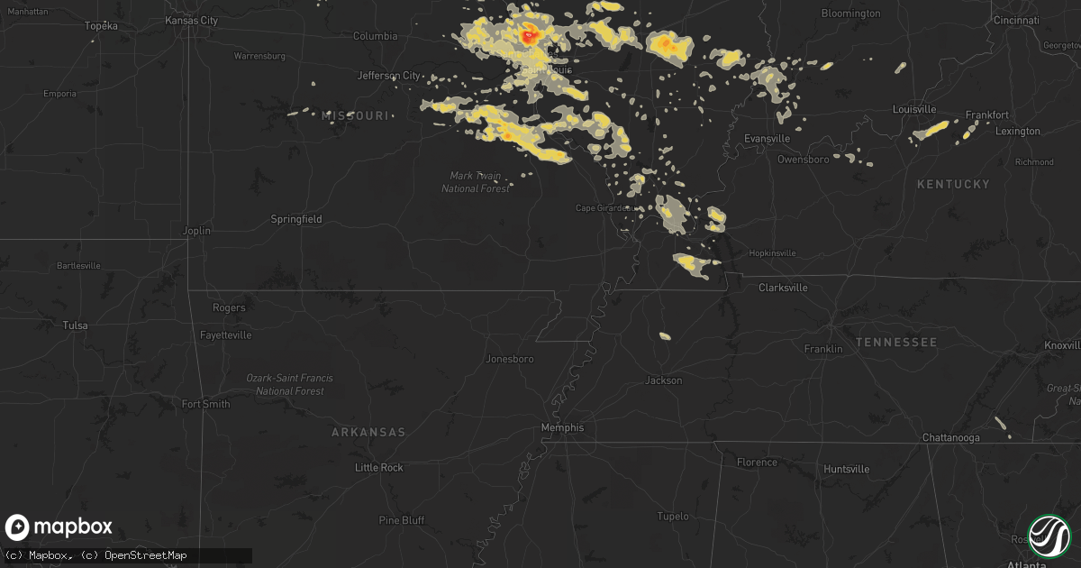
Hail Map on June 25, 2011
Get this storm
June 25 map
$229
one time, instant access
Download today. No call, no setup
Keep the $229
Bought the map and want the full workflow? Apply the entire $229 to a subscription within 7 days. None of it is wasted.
Every map, not just this one
This buys you this map. Subscription and you get every map we run, in the markets you choose from a few cities to whole states to nationwide. Plus real-time alerts the moment a storm fires.
Contact data
Name, contact info, occupancy, even credit band for addresses in the footprint. You go from where it hit to who to call.
Become the source they trust
Unlimited branding weather history reports on demand. You already have the documented answer ready for the property owner, and you are the one who showed up with it.
Property data and RoofTrace estimates
Pull up any address you have got, its value and the exact code rules for that jurisdiction, straight from One Click Code. Then RoofTrace estimates the squares, pitch, and roof value, priced the way you price.
States Impacted by Hail Map on June 25, 2011
Storm reports
Missouri
| Date | Description |
|---|---|
| 06/25/20111:42 AM CDT | A local report indicates 1.00 inch wind near 2 ENE ST JOSEPH |
| 06/25/20111:05 AM CDT | A local report indicates 1.00 inch wind near 2 WNW WELDON SPRING |
| 06/25/20111:05 AM CDT | A local report indicates 70 MPH wind near MARYLAND HEIGHTS |
| 06/25/20111:02 AM CDT | A local report indicates 1.00 inch wind near COTTLEVILLE |
| 06/25/201112:30 AM CDT | High voltage power lines down. |
| 06/25/201112:11 AM CDT | Highway 13 blocked by downed tree. |
| 06/25/201112:10 AM CDT | Numerous trees down and one structure damaged. |
| 06/25/201112:04 AM CDT | A local report indicates 60 MPH wind near MEADVILLE |
| 06/25/201112:03 AM CDT | Car blown off the road in old pattonsburg. |
| 06/25/201112:00 AM CDT | 2 foot diameter tree blown over near the intersection of lindbergh and watson roads |
| 06/24/201111:30 PM CDT | Large branch knocked out of tree onto power lines and then a house...near the intersection of jennings station and hoard road |
| 06/24/201111:24 PM CDT | Possible tornado...2 large billboards and debris blown across us hwy 67 just north of town |
| 06/24/201111:24 PM CDT | Est 50 mph winds |
| 06/24/201111:19 PM CDT | A local report indicates 1.00 inch wind near 6 S ROSEBUD |
| 06/24/201111:12 PM CDT | Possible tornado...2 large billboards and debris blown across us hwy 67 just north of town |
| 06/24/201111:10 PM CDT | A local report indicates 1.00 inch wind near BONNE TERRE |
| 06/24/201111:05 PM CDT | A local report indicates 65 MPH wind near BONNE TERRE |
| 06/24/201110:55 PM CDT | A local report indicates 1.00 inch wind near 4 NNW CADET |
| 06/24/201110:50 PM CDT | At the drive in movie theater |
| 06/24/20118:26 PM CDT | A local report indicates 1.00 inch wind near RICHWOODS |
Georgia
| Date | Description |
|---|---|
| 06/25/20116:57 PM CDT | Liberty county 911 center reported one tree blown down on pocahontas road. |
| 06/25/20116:45 PM CDT | Park service on cumberland island reported 4 to 5 inch diameter tree limbs blown down. Time of event based on radar. |
| 06/25/20115:10 PM CDT | Trees and powerline reported down near browntown road. Time of event based on radar. |
Indiana
| Date | Description |
|---|---|
| 06/25/20111:54 AM CDT | Power lines and multiple trees down. Trees blocking roads especially along cr 650w between duff and in 64. |
| 06/25/20111:50 AM CDT | Tree down |
Wyoming
| Date | Description |
|---|---|
| 06/24/20118:07 PM CDT | A local report indicates 1.00 inch wind near 2 N TORRINGTON |
North Dakota
| Date | Description |
|---|---|
| 06/25/20116:23 PM CDT | Coop observer in minot north hill reported straight line winds... Pea size hail... And 0.39 of rain in 5 to 15 mins |
| 06/25/20116:15 PM CDT | Hail lasted for 10 minutes. |
| 06/25/20115:42 PM CDT | A local report indicates 1.00 inch wind near 4 W MAXBASS |
| 06/25/20115:23 PM CDT | A local report indicates 1.00 inch wind near 4 E MAXBASS |
| 06/25/20115:23 PM CDT | A local report indicates 1.75 inch wind near PARSHALL |
| 06/25/20115:15 PM CDT | Hail lasted until 530 pm cdt. |
| 06/25/20115:09 PM CDT | Report relayed by media. |
| 06/25/20114:19 PM CDT | Public report relayed by broadcast media... |
| 06/25/20114:14 PM CDT | Mostly pea to quarter size hail with few ping pong ball size hail... |
| 06/25/20114:14 PM CDT | Pea to quarter size hail... Hail lasted about five minutes... |
| 06/25/20113:43 PM CDT | A local report indicates 1.00 inch wind near 2 S NEW TOWN |
| 06/25/20113:29 PM CDT | A local report indicates 1.25 inch wind near 5 S 4 BEARS LODGE |
| 06/24/201110:42 PM CDT | Quarter to walnut sized hail and very heavy rain. |
| 06/24/20119:29 PM CDT | Nickel and quarter sized hail just covered the ground. |
| 06/24/20119:14 PM CDT | Multiple reports of quarter sized hail in new salem by law enforcement and public... |
| 06/24/20118:40 PM CDT | Numerous nickel to quarter sized hail fail from 840 to 845 pm cdt. |
| 06/24/20118:40 PM CDT | Numerous nickel to quarter sized hail fail from 840 to 845 pm cdt. |
| 06/24/20118:24 PM CDT | A local report indicates 1.00 inch wind near FESSENDEN |
| 06/24/20118:23 PM CDT | Report relayed by broadcast media... Quarter to golf ball size hail... |
| 06/24/20117:33 PM CDT | Law enforcement reported that a barn roof was located on state highway 3...and is blocking traffic. Winds estimated at 85 mph. |
| 06/24/20117:20 PM CDT | A local report indicates 60 MPH wind near 2 NW BANTRY |
| 06/24/20117:20 PM CDT | A local report indicates 60 MPH wind near 2 NW BARTON |
Montana
| Date | Description |
|---|---|
| 06/25/20113:55 AM CDT | A local report indicates 1.00 inch wind near 20 SSE EKALAKA |
Illinois
| Date | Description |
|---|---|
| 06/25/20118:39 AM CDT | 1+ inch hail reported in massac county near round knob |
| 06/24/201111:56 PM CDT | Large limb blown onto power lines |
| 06/24/201111:45 PM CDT | Large limbs and trees down onto power lines |
| 06/24/201111:05 PM CDT | On northeast side of town. |
| 06/24/201110:00 PM CDT | Tree limbs and power lines down near route 78 and baldwin road |
| 06/24/20119:13 PM CDT | A local report indicates 1.00 inch wind near 2 E CHATHAM |
| 06/24/20119:00 PM CDT | Corrected time. Tree limbs and power lines down near route 78 and baldwin road |
| 06/24/20118:50 PM CDT | Power lines down. Time estimated. |
| 06/24/20118:45 PM CDT | Power lines down. Time estimated. |
| 06/24/20118:04 PM CDT | A local report indicates 1.00 inch wind near CHATHAM |
| 06/24/20118:00 PM CDT | Many 1 to 2 inch stones with a few up to 3 inches...observer went out and measured |
Tennessee
| Date | Description |
|---|---|
| 06/25/20117:15 AM CDT | A local report indicates 1.00 inch wind near 1 N BRADFORD |
South Dakota
| Date | Description |
|---|---|
| 06/25/20115:20 AM CDT | A local report indicates 60 MPH wind near 5 E PORCUPINE |
| 06/25/20115:05 AM CDT | A local report indicates 60 MPH wind near 6 E RALPH |
| 06/25/20114:15 AM CDT | A local report indicates 60 MPH wind near 5 SSW LUDLOW |
| 06/25/20113:01 AM CDT | A local report indicates 1.75 inch wind near 5 SSW CROCKER |
| 06/24/201110:50 PM CDT | Lost some siding on the back of the house. Estimated winds 60 to 70 mph. Garden flattened. |
| 06/24/201110:48 PM CDT | Kphp asos observation. |
| 06/24/201110:40 PM CDT | A local report indicates 1.75 inch wind near 10 E DOWNTOWN STURGIS |
| 06/24/201110:40 PM CDT | A local report indicates 60 MPH wind near 10 E DOWNTOWN STURGIS |
| 06/24/201110:05 PM CDT | A local report indicates 1.00 inch wind near 9 SW HEREFORD |
| 06/24/201110:00 PM CDT | 1.89 inches of rainfall |
| 06/24/20119:25 PM CDT | A local report indicates 1.00 inch wind near 3 SW DOWNTOWN RAPID CIT |
| 06/24/20119:20 PM CDT | A local report indicates 1.25 inch wind near 1 N DEERFIELD |
| 06/24/20119:10 PM CDT | A local report indicates 60 MPH wind near 5 NNW FAIRBURN |
| 06/24/20119:07 PM CDT | A local report indicates 60 MPH wind near 1 NNW SHERIDAN LAKE |
| 06/24/20119:04 PM CDT | A local report indicates 1.00 inch wind near 6 NE HILL CITY |
| 06/24/20119:00 PM CDT | A local report indicates 1.00 inch wind near HILL CITY |
| 06/24/20118:54 PM CDT | A local report indicates 1.75 inch wind near HILL CITY |
| 06/24/20118:50 PM CDT | A local report indicates 1.50 inch wind near HILL CITY |
| 06/24/20118:05 PM CDT | A local report indicates 60 MPH wind near 9 W JEWEL CAVE |
| 06/24/20117:45 PM CDT | A local report indicates 60 MPH wind near OELRICHS |
Alabama
| Date | Description |
|---|---|
| 06/25/20116:30 PM CDT | Estimated winds to 60 mph. Have received several reports of quarter size hail between hoover and pelham. |
| 06/25/20116:10 PM CDT | At the galleria mall |
Nebraska
| Date | Description |
|---|---|
| 06/25/20111:30 AM CDT | Delayed report...golf and tennis ball sized hail reported by public 5 miles n of brewster at 130 am |
| 06/25/20111:00 AM CDT | Delayed report |
| 06/25/201112:30 AM CDT | Delayed report |
| 06/24/201110:15 PM CDT | Delayed report...public reported golf ball sized hail 8 miles nw of chappell |
| 06/24/201110:04 PM CDT | Mostly pea to marble hail. |
| 06/24/20119:20 PM CDT | Numerous reports of golfball sized hail in and around sidney. Baseball sized hail was reported on the north side of town. |
| 06/24/20119:11 PM CDT | Golf ball sized hail on the west side of town. Ongoing at the time of the report. |
| 06/24/20119:07 PM CDT | Quarter sized hail on the north side of town. Spotter observed strong rotation to the west. |
| 06/24/20118:53 PM CDT | Debris reported from tornado just outside of town. |
| 06/24/20118:30 PM CDT | Two large trees down in potter due to strong winds. |
| 06/24/20118:28 PM CDT | Two rope tornadoes. |
| 06/24/20118:25 PM CDT | Semi blown over on interstate 80 just inside cheyenne county line. Damage caused by apparent tornado. |
| 06/24/20118:25 PM CDT | Semi blown over on interstate 80 just inside cheyenne county line. |
| 06/24/20117:54 PM CDT | Golf ball sized hail lasted from 654 pm until 656 pm mdt. |
| 06/24/20117:52 PM CDT | Brief touchdown. |
Kansas
| Date | Description |
|---|---|
| 06/25/201112:07 AM CDT | A local report indicates 1.75 inch wind near TROY |
Cities Impacted by Hail Map on June 25, 2011
- Chesterfield, MO
- Saint James, MO
- Cuba, MO
- Monticello, FL
- Lamont, FL
- Sidney, NE
- Lodgepole, NE
- Potter, NE
- Chappell, NE
- Gurley, NE
- Mohall, ND
- Voltaire, ND
- Velva, ND
- Chamberlain, SD
- Lower Brule, SD
- Batesland, SD
- Rushville, NE
- Turton, SD
- Clark, SD
- Raymond, SD
- Doland, SD
- Bryceville, FL
- Jacksonville, FL
- Callahan, FL
- Merriman, NE
- Pine Ridge, SD
- Pinckneyville, IL
- Coulterville, IL
- Bonne Terre, MO
- Richwoods, MO
- Blackwell, MO
- Rapid City, SD
- Campbellsburg, IN
- Carbondale, IL
- Owensville, MO
- Metropolis, IL
- Creal Springs, IL
- Lodgepole, SD
- Prairie City, SD
- Powers Lake, ND
- Stanley, ND
- Tioga, ND
- Keenes, IL
- Dahlgren, IL
- Marion, KY
- Kuttawa, KY
- Grand Rivers, KY
- Tiline, KY
- Taylorsville, KY
- Fisherville, KY
- Belknap, IL
- Louisville, KY
- Mount Washington, KY
- Farina, IL
- Antler, ND
- Keystone, SD
- Hill City, SD
- Custer, SD
- Upham, ND
- Winchester, IL
- Murrayville, IL
- Mount Eden, KY
- Warrenton, MO
- Sturgis, SD
- Sumner, IL
- Lakota, ND
- Jerseyville, IL
- Fieldon, IL
- Kane, IL
- Brighton, IL
- Bluford, IL
- Ingraham, IL
- Belleville, IL
- Mascoutah, IL
- Scott Air Force Base, IL
- Buffalo Gap, SD
- Waynesville, GA
- Hortense, GA
- Lansford, ND
- Maxbass, ND
- Cadet, MO
- Keytesville, MO
- Drake, ND
- Eolia, MO
- New Salem, ND
- Glen Ullin, ND
- Beulah, ND
- Hebron, ND
- Granville, ND
- Thompsonville, IL
- Litchfield, IL
- Plaza, ND
- Francisco, IN
- Hazleton, IN
- Patoka, IN
- Versailles, IL
- Beardstown, IL
- Norwich, ND
- New Rockford, ND
- Grace City, ND
- Mchenry, ND
- Pittsfield, IL
- Griggsville, IL
- Newcastle, WY
- Cobden, IL
- Goreville, IL
- Makanda, IL
- Dongola, IL
- Jonesboro, IL
- Anna, IL
- Buncombe, IL
- Allen, SD
- Wright City, MO
- Ewing, MO
- Ekalaka, MT
- Maddock, ND
- Noble, IL
- Olney, IL
- Calhoun, IL
- Dundas, IL
- Bridgeport, IL
- Claremont, IL
- Garvin, MN
- Tracy, MN
- Sawyer, ND
- Dix, NE
- Westhope, ND
- Glenburn, ND
- New Town, ND
- Parshall, ND
- Arenzville, IL
- Troy, KS
- Wathena, KS
- Oregon, MO
- Brownstown, IL
- Edgewood, IL
- Louisville, IL
- Mason, IL
- Saint Peter, IL
- Harrison, NE
- West Alton, MO
- Bridgeport, NE
- Hammond, MT
- Capitol, MT
- Elsah, IL
- Brussels, IL
- Portage Des Sioux, MO
- Grafton, IL
- Bland, MO
- Alliance, NE
- Edgemont, SD
- Oelrichs, SD
- Sparta, IL
- Loogootee, IN
- Montgomery, IN
- Brewster, NE
- Burlington, ND
- Minot, ND
- Des Lacs, ND
- Lake Park, MN
- Hitterdal, MN
- Hawley, MN
- Whitman, NE
- Milton, FL
- Reva, SD
- Freeburg, IL
- New Athens, IL
- Binford, ND
- Farmington, MO
- Saint Mary, MO
- Sainte Genevieve, MO
- Ryder, ND
- Rushville, MO
- Wounded Knee, SD
- Chadron, NE
- Gordon, NE
- Hay Springs, NE
- Manderson, SD
- Madison, FL
- Pinetta, FL
- Marianna, FL
- Sheyenne, ND
- Mount Olive, IL
- Shelbyville, KY
- Newark, MO
- Novelty, MO
- Edina, MO
- Fowler, IL
- Berthold, ND
- Rugby, ND
- Shoals, IN
- De Soto, MO
- Atchison, KS
- Ava, IL
- Campbell Hill, IL
- Rockwood, IL
- Crawford, NE
- Frankfort, KY
- Wall, SD
- Kimball, SD
- Platte, SD
- Cutler, IL
- Percy, IL
- Saint Louis, MO
- Denhoff, ND
- Saint Charles, MO
- Fredonia, KY
- Salem, KY
- Hardin, IL
- Batchtown, IL
- Hermosa, SD
- Willow City, ND
- Ironton, MO
- Carrington, ND
- Whitney, NE
- Whittington, IL
- Ina, IL
- Porcupine, SD
- Donnybrook, ND
- Brunswick, GA
- Zap, ND
- Moscow Mills, MO
- Bantry, ND
- Towner, ND
- Bisbee, ND
- Harrisburg, NE
- O'Fallon, MO
- Ashby, NE
- Oshkosh, NE
- Staunton, IL
- Fort Meade, SD
- Fairburn, SD
- Rosebud, MO
- Lingle, WY
- Torrington, WY
- Northwood, ND
- Lonedell, MO
- Saint Clair, MO
- De Soto, IL
- Leasburg, MO
- Robertsville, MO
- Dowell, IL
- Mineral Point, MO
- Grubville, MO
- Valles Mines, MO
- Luebbering, MO
- Prairie Du Rocher, IL
- Park Hills, MO
- Leadwood, MO
- Bourbon, MO
- Beaufort, MO
- Belle, MO
- Fletcher, MO
- Dittmer, MO
- Baldwin, IL
- Bloomsdale, MO
- Red Bud, IL
- Modoc, IL
- Du Quoin, IL
- Leslie, MO
- Gerald, MO
- Murphysboro, IL
- Waterloo, IL
- Evansville, IL
- Perryville, MO
- Sullivan, MO
- Tilden, IL
- Ellis Grove, IL
- Hillsboro, MO
- Potosi, MO
- Vergennes, IL
- Fults, IL
- Elkville, IL
- French Village, MO
- Steeleville, IL
- Festus, MO
- Walsh, IL
- Martin, SD
- Union Center, SD
- Jamestown, ND
- Spiritwood, ND
- Divernon, IL
- Pawnee, IL
- Kenmare, ND
- Tolley, ND
- Cathay, ND
- Ipswich, SD
- Carlyle, IL
- Centralia, IL
- Edwards, MO
- Lincoln, MO
- Pelham, AL
- Helena, AL
- Birmingham, AL
- Chaseley, ND
- Mulberry Grove, IL
- Smithboro, IL
- Midland, SD
- Onida, SD
- Warwick, ND
- Blakely, GA
- Kyle, SD
- Greenwood, FL
- Bascom, FL
- Gordon, AL
- Malone, FL
- Symsonia, KY
- Ross, ND
- Osteen, FL
- Dupree, SD
- Marion, IL
- Morrison, MO
- Hermann, MO
- Hurdsfield, ND
- Clermont, FL
- Fairfield, IL
- Shelbyville, MO
- Garden City, SD
- Conde, SD
- Bradley, SD
- Webster, SD
- Hayes, SD
- Walnut Grove, MN
- Winslow, IN
- Saint Francisville, IL
- Decker, IN
- Vincennes, IN
- Monroe City, IN
- Petersburg, IN
- Oakland City, IN
- Allendale, IL
- Princeton, IN
- Boonville, IN
- Tennyson, IN
- Highmore, SD
- Scottsburg, IN
- Philadelphia, MO
- Emden, MO
- Buffalo, SD
- Ludlow, SD
- Camp Crook, SD
- Lee, FL
- Hardin, KY
- Benton, KY
- Lisbon, ND
- Langdon, ND
- Thedford, NE
- Godfrey, IL
- Panama, IL
- Hillsboro, IL
- Sorento, IL
- Donnellson, IL
- Greenville, IL
- Walshville, IL
- Bloomfield, KY
- Evansville, WY
- Purdum, NE
- Holt, FL
- Pearl, IL
- Foley, MO
- Meredosia, IL
- Auburn, IL
- Webster, FL
- Hawesville, KY
- Cloverport, KY
- East Alton, IL
- Hartford, IL
- Berger, MO
- New Haven, MO
- Rushville, IL
- Mount Sterling, IL
- Vandalia, IL
- Piedmont, SD
- Kingsland, GA
- Hilliard, FL
- Butler, IL
- Quinn, SD
- Oberon, ND
- Webster, ND
- Shepherdsville, KY
- Camp Point, IL
- Coatsburg, IL
- Fessenden, ND
- Eureka, MO
- High Ridge, MO
- Loami, IL
- Chatham, IL
- Carrollton, IL
- Old Monroe, MO
- Winfield, MO
- Texico, IL
- Mount Vernon, IL
- Chambersburg, IL
- Baylis, IL
- Perry, IL
- Barnhart, MO
- Johnsonville, IL
- Pukwana, SD
- Rockbridge, IL
- Saint Peters, MO
- Ramsey, IL
- Foristell, MO
- Wentzville, MO
- Kearney, NE
- Woodbine, GA
- Harvey, ND
- Tolna, ND
- Hawk Point, MO
- East Saint Louis, IL
- Golden Eagle, IL
- Dow, IL
- Old Town, FL
- Bowdon, ND
- Owaneco, IL
- Pacific, MO
- Cody, NE
- Grand Ridge, FL
- Sneads, FL
- Troy, MO
- Stuart, FL
- Jupiter, FL
- Kennebec, SD
- Slater, MO
- Edwardsville, IL
- Wood River, IL
- Roxana, IL
- Bethalto, IL
- Liberty, IL
- Plainville, IL
- Payson, IL
- Cherry Creek, SD
- Milesville, SD
- Raymond, IL
- Irving, IL
- Witt, IL
- Alton, IL
- Darien, GA
- Dunnellon, FL
- Smithton, IL
- Glenfield, ND
- Knox City, MO
- Clifton Hill, MO
- Huntsville, MO
- Salisbury, MO
- Agar, SD
- Dunseith, ND
- Carlinville, IL
- Paducah, KY
- Jacksonville, IL
- Easton, KS
- Uriah, AL
- Atmore, AL
- Rolette, ND
- Cando, ND
- Lance Creek, WY
- Hot Springs, SD
- Arnold, MO
- Imperial, MO
- Turtle Lake, ND
- Butte, ND
- Ruso, ND
- Benedict, ND
- Shobonier, IL
- Xenia, IL
- Kinmundy, IL
- Flora, IL
- Saint Elmo, IL
- Coffeen, IL
- Pocahontas, IL
- Wetmore, KS
- Fort Pierre, SD
- Bison, SD
- Meadow, SD
- Eldred, IL
- Lake Saint Louis, MO
- Hazelwood, MO
- Maryville, IL
- Marissa, IL
- Cottage Hills, IL
- East Carondelet, IL
- Columbia, IL
- Silex, MO
- Glen Carbon, IL
- Collinsville, IL
- High Hill, MO
- Bunker Hill, IL
- New Douglas, IL
- Dupo, IL
- Dorsey, IL
- Millstadt, IL
- Pevely, MO
- Truesdale, MO
- Worden, IL
- Alhambra, IL
- New Florence, MO
- Piasa, IL
- Medora, IL
- Florissant, MO
- House Springs, MO
- Moro, IL
- Truxton, MO
- Valmeyer, IL
- Hamburg, IL
- Bridgeton, MO
- Maryland Heights, MO
- South Roxana, IL
- Venice, IL
- Valley Park, MO
- Montgomery City, MO
- Earth City, MO
- Bellflower, MO
- Jonesburg, MO
- Livingston, IL
- Taylor Springs, IL
- Granite City, IL
- Ballwin, MO
- Fenton, MO
- Lenzburg, IL
- Gillespie, IL
- Fillmore, IL
- Elsberry, MO
- Saint Ann, MO
- Wildwood, MO
- Fidelity, IL
- Marietta, MN
- Ellsworth, NE
- Canton, MO
- Redfield, SD
- Ainsworth, NE
- Breckenridge, MO
- Ludlow, MO
- Black Hawk, SD
- Bainbridge, GA
- Brinson, GA
- Goodrich, ND
- Lawrenceville, IL
- Blackshear, GA
- Hemingford, NE
- Centralia, KS
- Union, MO
- Webster, KY
- Hampton, KY
- Smithland, KY
- Waverly, GA
- Shipman, IL
- Deering, ND
- Presho, SD
- Clayton, IL
- Roodhouse, IL
- Bluffs, IL
- New Salem, IL
- Ashley, IL
- Mayfield, KY
- Ullin, IL
- Bushnell, FL
- Cowgill, MO
- Braymer, MO
- Fairview Heights, IL
- O'Fallon, IL
- Madison, MN
- Townsend, GA
- Kevil, KY
- Palermo, ND
- Mcville, ND
- Lawrenceburg, KY
- West Frankfort, IL
- Saint Jacob, IL
- Troy, IL
- Cedar Hill, MO
- Eddyville, IL
- Simpson, IL
- Stonefort, IL
- Highland, IL
- Golconda, IL
- Geneva, FL
- Tuthill, SD
- Ledbetter, KY
- Karnak, IL
- Vienna, IL
- West Paducah, KY
- Grantsburg, IL
- Brookport, IL
- Lancaster, KS
- Cummings, KS
- Nemo, SD
- Deadwood, SD
- Glenarm, IL
- New Underwood, SD
- Bradford, TN
- Milan, TN
- Atwood, TN
- Harned, KY
- Garfield, KY
- Kirksey, KY
- Hickory, KY
- Green Castle, MO
- Novinger, MO
- Alexander, IL
- Waddy, KY
- Bingham, IL
- Lynnville, IN
- Elberfeld, IN
- Chandler, IN
- Pierre, SD
- Damascus, GA
- Westphalia, MO
- Taylorville, IL
- Wheatland, IN
- Hunnewell, MO
- Shelbina, MO
- Groveland, FL
- Enfield, IL
- Deltona, FL
- Gilbertsville, KY
- Greenfield, IL
- Chester, IL
- La Belle, MO
- Unionville, MO
- Box Elder, SD
- Ellsworth Afb, SD
- New Canton, IL
- Hardinsburg, KY
- Tamms, IL
- Johnstown, NE
- Wayne City, IL
- Rutledge, MO
- Cypress, IL
- Grand Chain, IL
- Milnor, ND
- Cayuga, ND
- Karlsruhe, ND
- New Berlin, IL
- Morrill, NE
- Jefferson City, MO
- Circleville, KS
- Holabird, SD
- Esmond, ND
- Gentryville, IN
- Dale, IN
- Dahlen, ND
- Fordville, ND
- Henry, SD
- Mount Carmel, IL
- West Salem, IL
- Eddyville, KY
- Opdyke, IL
- Belle Rive, IL
- Concord, IL
- Virden, IL
- Assumption, IL
- Rochester, IL
- Waverly, IL
- Ashland, IL
- Bulpitt, IL
- Virginia, IL
- Kincaid, IL
- Edinburg, IL
- Frederick, IL
- Pana, IL
- Chapin, IL
- Palatka, FL
- Benton, IL
- Chamois, MO
- Bottineau, ND
- Roseglen, ND
- Funk, NE
- Lumberton, MS
- Greenville, FL
- Balta, ND
- Palmer, IL
- Morrisonville, IL
- Golden Valley, ND
- Edmore, ND
- Starkweather, ND
- Hampden, ND
- Mendon, IL
- Ursa, IL
- Cisne, IL
- Pekin, ND
- Center Hill, FL
- Saint Michael, ND
- Wanblee, SD
- Whitewood, SD
- Warsaw, MO
- Gorham, IL
- Lisco, NE
- Lead, SD
- Calera, AL
- New Smyrna Beach, FL
- Reliance, SD
- Bowling Green, MO
- Atlanta, MO
- La Plata, MO
- Caputa, SD
- Hernando, FL
- Lecanto, FL
- Inverness, FL
- Corning, KS
- Goff, KS
- Lusk, WY
- Ozark, IL
- Oakdale, IL
- Winter Garden, FL
- Pomona, IL
- Charleston, TN
- Benton, TN
- Mitchell, IN
- Harrold, SD
- Mims, FL
- Worthington, MO
- Queen City, MO
- Nokomis, IL
- Kaiser, MO
- Osage Beach, MO
- Lake Ozark, MO
- Eldon, MO
- Soldier, KS
- Dieterich, IL
- Alma, IL
- Iuka, IL
- Vernon, IL
- Makoti, ND
- Michigan, ND
- Homosassa, FL
- Pittsburg, IL
- Hitchcock, SD
- Camdenton, MO
- Bessemer, AL
- Scranton, ND
- Nashville, IL
- Keene, ND
- Mandaree, ND
- White Hall, IL
- Gilliam, MO
- Okawville, IL
- Orlando, FL
- Miller City, IL
- Cairo, IL
- Revillo, SD
- Clarksville, MO
- Scheller, IL
- Waltonville, IL
- Jacob, IL
- Edgeley, ND
- Hoyleton, IL
- Mansfield, SD
- Newburg, ND
- Gravois Mills, MO
- Souris, ND
- White Oak, GA
- Seneca, SD
- Washington, IN
- Villa Ridge, IL
- Richview, IL
- Loose Creek, MO
- Stendal, IN
- Villa Ridge, MO
- Surrey, ND
- Auburn, KS
- Wakarusa, KS
- Shorterville, AL
- Orient, SD
- Sykeston, ND
- Plainville, IN
- Miami, MO
- Geff, IL
- Ocala, FL
- Golden Gate, IL
- Mount Erie, IL
- Steelville, MO
- Huntsville, IL
- Oak Hill, FL
- Curryville, MO
- Meta, MO
- Denton, KS
- Wallace, SD
- Bristol, SD
- Salem, IL
- Donalsonville, GA
- Newton, IL
- Bay Minette, AL
- New London, MO
- Salem, IN
- Maitland, MO
- Fillmore, MO
- Bunnell, FL
- Maywood, MO
- Durham, MO
- Marthasville, MO
- Kramer, ND
- Branford, FL
- Hillview, IL
- Mitchell, NE
- Cole Camp, MO
- Live Oak, FL
- Lesterville, MO
- Anamoose, ND
- Fredericktown, MO
- Andover, SD
- Florence, SD
- Frankford, MO
- Louisiana, MO
- Bismarck, ND
- Washington, MO
- Finchville, KY
- Brooks, KY
- Bruceville, IN
- Bicknell, IN
- Gregory, SD
- Barnhill, IL
- Mill Shoals, IL
- Carrier Mills, IL
- Winchester, KS
- Nortonville, KS
- Leavenworth, KS
- Mcclusky, ND
- Carmi, IL
- Olmsted, IL
- Camden, IL
- Clay City, IL
- Carterville, IL
- Geddes, SD
- Albion, IL
- Frisco City, AL
- Havensville, KS
- Memphis, MO
- Brooksville, FL
- Watertown, SD
- Wolf Lake, IL
- Almo, KY
- Boaz, KY
- Farmington, KY
- Murray, KY
- Dexter, KY
- Middletown, MO
- Windermere, FL
- Howes, SD
- Lebanon Junction, KY
- Rockham, SD