Hail Map on June 16, 2020
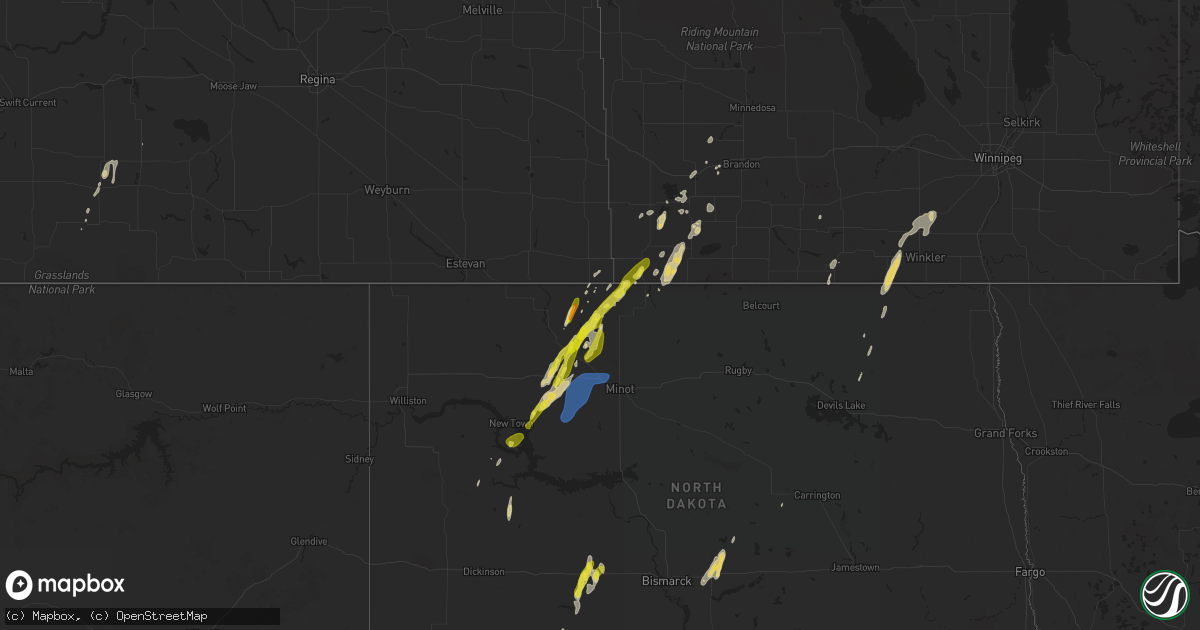
Get this storm
June 16 map
$229
one time, instant access
Download today. No call, no setup
Keep the $229
Bought the map and want the full workflow? Apply the entire $229 to a subscription within 7 days. None of it is wasted.
Every map, not just this one
This buys you this map. Subscription and you get every map we run, in the markets you choose from a few cities to whole states to nationwide. Plus real-time alerts the moment a storm fires.
Contact data
Name, contact info, occupancy, even credit band for addresses in the footprint. You go from where it hit to who to call.
Become the source they trust
Unlimited branding weather history reports on demand. You already have the documented answer ready for the property owner, and you are the one who showed up with it.
Property data and RoofTrace estimates
Pull up any address you have got, its value and the exact code rules for that jurisdiction, straight from One Click Code. Then RoofTrace estimates the squares, pitch, and roof value, priced the way you price.
States Impacted by Hail Map on June 16, 2020
Storm reports
Arizona
| Date | Description |
|---|---|
| 06/15/202011:07 PM CDT | At 406 PM MST, a severe thunderstorm was located near Douglas, moving northeast at 20 mph. HAZARD...60 mph wind gusts and quarter size hail. SOURCE...Radar indicated. IMPACT...Hail damage to vehicles is expected. Expect wind damage to roofs, siding, and trees. Locations impacted include... Douglas, Bisbee-Douglas Airport and Pirtleville. This includes the following highways... Route 80 between mile markers 361 and 398. Route 191 between mile markers 1 and 7. |
Texas
| Date | Description |
|---|---|
| 06/16/20204:55 AM CDT | At 955 PM CDT, a severe thunderstorm was located 26 miles northeast of Persimmon Gap, or 31 miles southwest of Sanderson, moving southeast at 15 mph. HAZARD...Ping pong ball size hail and 60 mph wind gusts. SOURCE...Radar indicated. IMPACT...People and animals outdoors will be injured. Expect hail damage to roofs, siding, windows, and vehicles. Expect wind damage to roofs, siding, and trees. This severe thunderstorm will remain over mainly rural areas of east central Brewster County. |
North Dakota
| Date | Description |
|---|---|
| 06/16/20206:51 AM CDT | At 1151 PM CDT, a severe thunderstorm was located 7 miles southwest of Lansford, or 12 miles south of Mohall, moving northeast at 45 mph. HAZARD...60 mph wind gusts and half dollar size hail. SOURCE...Radar indicated. IMPACT...Hail damage to vehicles is expected. Expect wind damage to roofs, siding, and trees. This severe thunderstorm will be near... Lansford around 1200 AM CDT. Mohall around 1205 AM CDT. Antler around 1225 AM CDT. Westhope around 1230 AM CDT.Other locations impacted by this severe thunderstorm include Landaand Grano. |
| 06/16/20206:21 AM CDT | At 1121 PM CDT, a severe thunderstorm was located 5 miles southwest of Mohall, moving northeast at 45 mph. HAZARD...Ping pong ball size hail and 60 mph wind gusts. SOURCE...Radar indicated. IMPACT...People and animals outdoors will be injured. Expect hail damage to roofs, siding, windows, and vehicles. Expect wind damage to roofs, siding, and trees. This severe thunderstorm will be near... Mohall around 1130 PM CDT. Antler around 1150 PM CDT.Other locations impacted by this severe thunderstorm include Loraine. |
| 06/16/20206:13 AM CDT | At 1113 PM CDT/1013 PM MDT/, a severe thunderstorm was located 6 miles northeast of Dunn Center, or 12 miles east of Killdeer, moving north at 35 mph. HAZARD...60 mph wind gusts and quarter size hail. SOURCE...Radar indicated. IMPACT...Hail damage to vehicles is expected. Expect wind damage to roofs, siding, and trees. This severe thunderstorm will be near... Mckenzie Bay Recreation Area around 1135 PM CDT.Other locations impacted by this severe thunderstorm include SkunkCreek Bay Recreation Area. |
| 06/16/20206:05 AM CDT | At 1105 PM CDT, severe thunderstorms were located along a line extending from 6 miles southwest of Hannover to 7 miles north of New Salem to 5 miles northwest of Fish Creek Dam, moving northeast at 30 mph. HAZARD...60 mph wind gusts and quarter size hail. SOURCE...Radar indicated. IMPACT...Hail damage to vehicles is expected. Expect wind damage to roofs, siding, and trees. Severe thunderstorms will be near... Hannover around 1120 PM CDT. Center around 1125 PM CDT. Lake Harmon around 1145 PM CDT. Cross Ranch State Park around 1155 PM CDT. Washburn around 1200 AM CDT.Other locations impacted by these severe thunderstorms include Price,Sweet Briar Lake, Crown Butte Lake, Sanger, Hensler, Fort Clark,Judson and Nelson Lake. |
| 06/16/20205:56 AM CDT | At 1055 PM CDT, a severe thunderstorm was located 11 miles southwest of Sherwood, or 12 miles west of Mohall, moving northeast at 40 mph. HAZARD...Ping pong ball size hail and 60 mph wind gusts. SOURCE...Radar indicated. IMPACT...People and animals outdoors will be injured. Expect hail damage to roofs, siding, windows, and vehicles. Expect wind damage to roofs, siding, and trees. This severe thunderstorm will be near... Sherwood around 1115 PM CDT.Other locations impacted by this severe thunderstorm include Loraine,Tolley and Norma. |
| 06/16/20205:32 AM CDT | At 1032 PM CDT, a severe thunderstorm was located over Van Hook Park, or 27 miles south of Stanley, moving northeast at 50 mph. HAZARD...60 mph wind gusts and half dollar size hail. SOURCE...Radar indicated. IMPACT...Hail damage to vehicles is expected. Expect wind damage to roofs, siding, and trees. This severe thunderstorm will be near... Van Hook Park around 1035 PM CDT. Parshall around 1045 PM CDT.Other locations impacted by this severe thunderstorm include ParshallBay Recreation Area and Pouch Point Recreation Area. |
| 06/16/20205:28 AM CDT | At 1028 PM CDT, a severe thunderstorm was located 8 miles south of Blaisdell, or 14 miles southeast of Stanley, moving northeast at 55 mph. HAZARD...60 mph wind gusts and half dollar size hail. SOURCE...Radar indicated. IMPACT...Hail damage to vehicles is expected. Expect wind damage to roofs, siding, and trees. This severe thunderstorm will be near... Blaisdell around 1035 PM CDT. Donnybrook around 1055 PM CDT. Greene around 1110 PM CDT.Other locations impacted by this severe thunderstorm includeHartland, Grano, Coulee and Tagus. |
| 06/16/20205:26 AM CDT | At 1026 PM CDT/926 PM MDT/, severe thunderstorms were located along a line extending from 7 miles southeast of Glen Ullin to 4 miles southeast of Heart Butte Dam, moving northeast at 30 mph. HAZARD...60 mph wind gusts and quarter size hail. SOURCE...Radar indicated. IMPACT...Hail damage to vehicles is expected. Expect wind damage to roofs, siding, and trees. Severe thunderstorms will be near... Glen Ullin around 1035 PM CDT. Almont around 1100 PM CDT. New Salem around 1120 PM CDT. |
| 06/16/20204:09 AM CDT | At 908 PM MDT, a severe thunderstorm was located near Glad Valley, or 20 miles north of Dupree, moving northeast at 50 mph. HAZARD...70 mph wind gusts and penny size hail. SOURCE...Radar indicated. IMPACT...Expect considerable tree damage. Damage is likely to mobile homes, roofs, and outbuildings. Locations impacted include... Mclaughlin, Mcintosh, Isabel, Morristown, Firesteel, Watauga, Bullhead, Black Horse, Shambo Ranch and Klein Ranch. |
| 06/16/20201:45 AM CDT | Large tree branches were blow down in tuttle. They also received 1.5 inches of rain. |
| 06/16/20201:32 AM CDT | Estimated 80 mph winds caused the loss of two barns and a pole building. Report received via social media. |
| 06/16/20201:31 AM CDT | Nddot mesonet site nd002 at mile marker 184 on interstate 94. |
| 06/16/202012:43 AM CDT | Asos station kmot minot airport. |
| 06/16/202012:42 AM CDT | Awos station kmib minot afb. |
| 06/15/202011:29 PM CDT | Report relayed by media. |
| 06/15/202011:24 PM CDT | Thunderstorm winds damaged the screen door to a house. The winds were accompanied by pea size hail. Report received via social media. |
| 06/15/202010:47 PM CDT | Storm spotter |
South Dakota
| Date | Description |
|---|---|
| 06/16/20204:05 AM CDT | At 903 PM MDT, a severe thunderstorm was located 3 miles northeast of Iron Lightning, or 14 miles northwest of Dupree, moving northeast at 45 mph. HAZARD...70 mph wind gusts and penny size hail. SOURCE...Radar indicated. Wind gusts around 70 mph were recorded at the Faith airport. IMPACT...Expect considerable tree damage. Damage is likely to mobile homes, roofs, and outbuildings. This severe thunderstorm will remain over mainly rural areas of northwestern Ziebach County north of Dupree. |
| 06/16/20203:15 AM CDT | At 815 PM MDT, a severe thunderstorm was located 7 miles southeast of Opal, or 18 miles southwest of Faith, moving northeast at 45 mph. HAZARD...60 mph wind gusts and half dollar size hail. SOURCE...Radar indicated. IMPACT...Hail damage to vehicles is expected. Expect wind damage to roofs, siding, and trees. This severe thunderstorm will be near... Durkee Lake around 835 PM MDT. Faith around 840 PM MDT. Arrow Head Buttes around 850 PM MDT. Iron Lightning around 900 PM MDT. |
| 06/15/20209:55 PM CDT | A local report indicates 75 MPH wind near 1 WSW RED ELM |
| 06/15/20209:49 PM CDT | A local report indicates 72 MPH wind near 1 NNE FAITH |
Wyoming
| Date | Description |
|---|---|
| 06/15/20207:35 PM CDT | Quarter sized hail reported on sr-189 about 1.5 miles north of i-80. |
Nevada
| Date | Description |
|---|---|
| 06/16/20205:55 AM CDT | At 1054 AM PDT, a severe thunderstorm was located 9 miles west of Wells, moving east at 20 mph. HAZARD...60 mph wind gusts and quarter size hail. SOURCE...Radar indicated. IMPACT...Hail damage to vehicles is expected. Expect wind damage to roofs, siding, and trees. Locations impacted include... Wells, Moor Summit and Hd Summit. |
Utah
| Date | Description |
|---|---|
| 06/15/20209:39 PM CDT | At 238 PM MDT, a severe thunderstorm was located 16 miles southwest of Park Valley, or 44 miles northeast of Montello, moving east at 15 mph. HAZARD...Quarter size hail. SOURCE...Radar indicated. IMPACT...Damage to vehicles is expected. This severe thunderstorm will remain over mainly rural areas of central Box Elder County. |
| 06/15/20209:23 PM CDT | At 221 PM MDT, a severe thunderstorm was located 25 miles southwest of Park Valley, or 33 miles northeast of Montello, moving northeast at 35 mph. HAZARD...60 mph wind gusts and quarter size hail. SOURCE...Radar indicated. IMPACT...Hail damage to vehicles is expected. Expect wind damage to roofs, siding, and trees. Locations impacted include... Park Valley and Rosette. This includes Utah Route 30 between mile markers 30 and 58. |
Cities Impacted by Hail Map on June 16, 2020
- Langdon, ND
- Maida, ND
- Lansford, ND
- Carpio, ND
- Union Center, SD
- Faith, SD
- Lemmon, SD
- New Salem, ND
- Enning, SD
- Mud Butte, SD
- White Owl, SD
- Sturgis, SD
- Glen Ullin, ND
- Almont, ND
- Elgin, ND
- Sterling, ND
- Wing, ND
- Driscoll, ND
- Berthold, ND
- Sarles, ND
- Rapid City, SD
- Donnybrook, ND
- Sykeston, ND
- New Leipzig, ND
- Mohall, ND
- Coleman, OK
- Parshall, ND
- Gilmer, TX
- Palermo, ND
- Plaza, ND
- Douglas, AZ
- Tolley, ND
- Sherwood, ND
- Mott, ND
- Dupree, SD
- Souris, ND
- Antler, ND
- Ada, OK
- Meadow, SD
- Kenmare, ND
- Hettinger, ND
- Dunn Center, ND
- Halliday, ND
- Bokchito, OK
- Killdeer, ND
- Pennington, TX
- Maxbass, ND
- Commerce, TX
- Klondike, TX
- Piedmont, SD
- New Town, ND
- Alsen, ND
- Custer, SD
- Webster, ND
- Hill City, SD
- Tuttle, ND
- Marathon, TX
- Animas, NM
- Park Valley, UT
- Burlington, ND
- Minot, ND
- Des Lacs, ND
- Makoti, ND
- Glenburn, ND