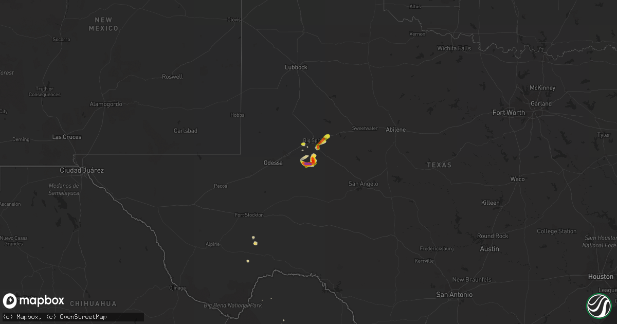
Hail Map on June 15, 2014
Get this storm
June 15 map
$229
one time, instant access
Download today. No call, no setup
Keep the $229
Bought the map and want the full workflow? Apply the entire $229 to a subscription within 7 days. None of it is wasted.
Every map, not just this one
This buys you this map. Subscription and you get every map we run, in the markets you choose from a few cities to whole states to nationwide. Plus real-time alerts the moment a storm fires.
Contact data
Name, contact info, occupancy, even credit band for addresses in the footprint. You go from where it hit to who to call.
Become the source they trust
Unlimited branding weather history reports on demand. You already have the documented answer ready for the property owner, and you are the one who showed up with it.
Property data and RoofTrace estimates
Pull up any address you have got, its value and the exact code rules for that jurisdiction, straight from One Click Code. Then RoofTrace estimates the squares, pitch, and roof value, priced the way you price.
States Impacted by Hail Map on June 15, 2014
Storm reports
Iowa
| Date | Description |
|---|---|
| 06/15/201412:09 AM CDT | A local report indicates 1.00 inch wind near 2 NW SALIX |
Kansas
| Date | Description |
|---|---|
| 06/14/201411:30 PM CDT | A local report indicates 1.25 inch wind near 1 NW COLDWATER |
| 06/14/201410:57 PM CDT | A local report indicates 1.00 inch wind near COLDWATER |
Wisconsin
| Date | Description |
|---|---|
| 06/15/20146:05 AM CDT | Trees bent on tops and up to 6 inch diameter branches down. Time estimated by radar. |
Florida
| Date | Description |
|---|---|
| 06/15/20146:05 PM CDT | Ping pong ball sized hail off of caraway drive in poinciana. |
| 06/15/20145:57 PM CDT | Quarter to golf ball sized hail reported near heron rd. And marigold ave. In poinciana. |
| 06/15/20143:35 PM CDT | Trailer blown over and powerlines down. |
Texas
| Date | Description |
|---|---|
| 06/15/20146:55 PM CDT | Golf ball-sized hail with significant car damage reported just northwest of garden city. |
| 06/14/20147:05 PM CDT | A local report indicates 1.75 inch wind near GARDEN CITY |
Cities Impacted by Hail Map on June 15, 2014
- Labelle, FL
- Lake Wales, FL
- Haines City, FL
- Kissimmee, FL
- Stanton, TX
- Garden City, TX
- Kathleen, FL
- Lakeland, FL
- Cocoa, FL
- Coahoma, TX
- Big Spring, TX
- Taylor, NE
- Sargent, NE
- Geneva, FL
- Centralia, IL
- Coldwater, KS
- Davenport, FL
- Lithia, FL
- Comstock, NE
- Ord, NE
- Naples, FL
- Rockledge, FL
- Moore Haven, FL
- Winter Haven, FL
- Auburndale, FL
- Wildwood, FL
- The Villages, FL
- Leesburg, FL
- Carlyle, IL
- Myakka City, FL
- Protection, KS
- Westbrook, TX
- Tavares, FL
- Immokalee, FL
- Fort Myers, FL
- Summerton, SC
- Branford, FL
- Punta Gorda, FL
- Witten, SD
- Fort Stockton, TX
- Riceboro, GA
- Citra, FL
- Cross, SC
- Loup City, NE
- Fort Pierce, FL
- Mims, FL
- Brandon, FL
- Tampa, FL
- Republic, KS
- Williston, FL
- Archer, FL
- Marathon, TX
- O'Brien, FL
- Hulbert, OK
- Arcadia, NE
- Elyria, NE
- Holly Hill, SC
- Kadoka, SD
- Ashton, NE
- Reddick, FL
- Burwell, NE
- Indiantown, FL
- Fruitland Park, FL
- Oxford, FL
- Arcadia, FL
- Reynolds, ND
- Trenton, FL
- Cape Coral, FL
- Buffalo, OK
- Clewiston, FL
- Nowata, OK
- Manning, SC
- Collinsville, OK
- Groveland, FL
- Clermont, FL
- Alma, GA
- Hoyleton, IL
- Orlando, FL
- Harleyville, SC
- Fellsmere, FL
- Dorchester, SC