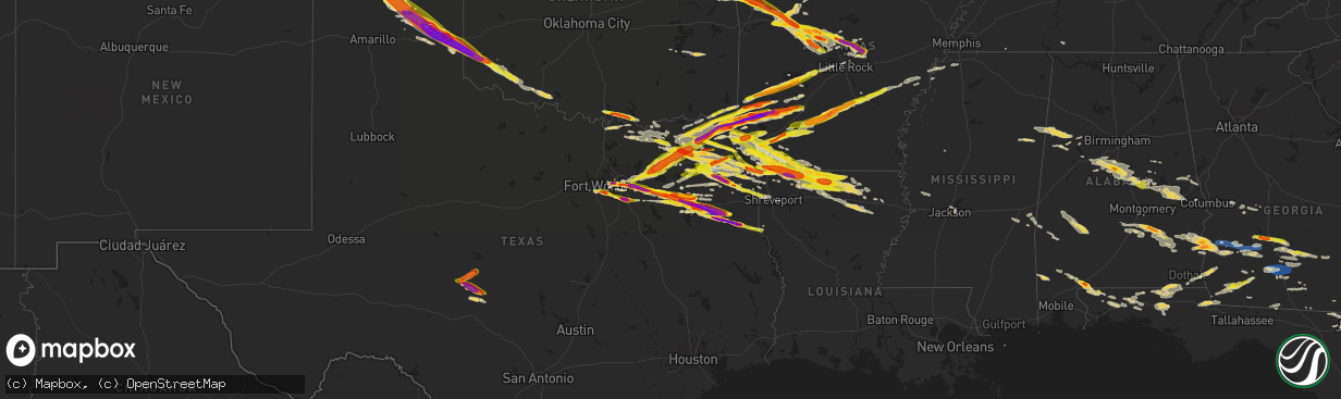
Hail Map on June 13, 2023
The weather event on June 13, 2023 includes Hail, Wind, and Tornado maps. 16 states and 797 cities were impacted and suffered possible damage. The total estimated number of properties impacted is 546,427.
Want more than just the map?
Turn this storm into a full workflow.
- Owner + property data so you know who to knock
- OnDemand branded weather history reports to win the "did we even have hail?" argument
- RoofTrace estimate so reps stop guessing numbers at the door
Bought this map? Upgrade within 7 days and we'll credit the $230. (10-15 min setup call)
Hail
Wind
Tornado
546,427
Estimated number of impacted properties by a 1.00" hail or larger222,647
Estimated number of impacted properties by a 1.75" hail or larger66,988
Estimated number of impacted properties by a 2.50" hail or largerStates Impacted by Hail Map on June 13, 2023
Storm reports
Louisiana
| Date | Description |
|---|---|
| 06/13/20236:59 PM CDT | Hail up to quarter size reported from a family dollar in logansport. Time estimated by radar. |
| 06/12/202311:25 PM CDT | Reports of trees down in and around the haynesville area. |
| 06/12/202310:32 PM CDT | A local report indicates 1.50 inch wind near Bernice |
| 06/12/202310:00 PM CDT | A local report indicates 1.00 inch wind near 3 N Homer |
| 06/12/20239:23 PM CDT | A local report indicates 1.75 inch wind near Springhill |
| 06/12/20238:03 PM CDT | Report from mping: hen egg |
| 06/12/20237:29 PM CDT | Quarter size hail reported by public at a gas station in mira. Time estimated by radar. |
Arkansas
| Date | Description |
|---|---|
| 06/13/20236:11 PM CDT | A local report indicates 1.75 inch wind near Antoine |
| 06/13/20236:09 PM CDT | Public reported hail a little larger than a hen egg at the family dolla |
| 06/13/20236:09 PM CDT | Public reported hail a little larger than a hen egg at the family dollar in dierks. Time estimated by radar. |
| 06/13/20236:08 PM CDT | A local report indicates 1.75 inch wind near Delight |
| 06/13/20236:08 PM CDT | Report from mping: quarter |
| 06/13/20236:06 PM CDT | A local report indicates 1.75 inch wind near 1 SW Antoine |
| 06/13/20235:55 PM CDT | A local report indicates 2.50 inch wind near 1 SSE Roy |
| 06/13/20235:47 PM CDT | Law enforcement reports quarter sized hail at the sevier county sheriffs office. |
| 06/13/20235:43 PM CDT | Public reported hail up to hen egg size. Time estimated by radar. |
| 06/13/20235:31 PM CDT | A local report indicates 2.75 inch wind near Winthrop |
| 06/13/20235:25 PM CDT | Trained spotter report of 2.75 inch hail 5 miles nnw of ben lomond. Time estimated using radar. |
| 06/13/20235:23 PM CDT | A local report indicates 2.50 inch wind near 5 NW Ben Lomond |
| 06/13/20238:01 AM CDT | Ashdown paper mill. |
| 06/13/20236:58 AM CDT | Large portion of a tree down over a truck. |
| 06/13/20236:50 AM CDT | A local report indicates 1.50 inch wind near Austin |
| 06/13/20236:45 AM CDT | A local report indicates 1.75 inch wind near 1 NW Woodlawn Addition |
| 06/13/20236:37 AM CDT | Report via social media. |
| 06/13/20236:34 AM CDT | Report from mping: quarter |
| 06/13/20236:30 AM CDT | A local report indicates 1.75 inch wind near 3 ENE Vilonia |
| 06/13/20236:25 AM CDT | A local report indicates 1.50 inch wind near 2 S Holland |
| 06/13/20236:12 AM CDT | Report via social media shows tree down over a dirt road. |
| 06/13/20234:25 AM CDT | A local report indicates 1.75 inch wind near 1 W West Fork |
| 06/13/20234:13 AM CDT | A local report indicates 1.75 inch wind near Winslow |
| 06/13/20234:08 AM CDT | Corrects previous hail report from 1 w west fork. |
| 06/13/20231:03 AM CDT | Report from mping: quarter |
| 06/13/202312:28 AM CDT | Reports of quarter sized hail with thunderstorm near arkansas 29 and county road 16... North of canfield. |
| 06/13/202312:02 AM CDT | Report from mping: ping pong ball |
| 06/12/202310:42 PM CDT | A local report indicates 1.25 inch wind near Bradley |
| 06/12/20239:25 PM CDT | A local report indicates 1.75 inch wind near 6 SW Taylor |
| 06/12/20239:05 PM CDT | Report from mping: golf ball |
| 06/12/20239:03 PM CDT | Sutton community. |
| 06/12/20238:22 PM CDT | A local report indicates 1.75 inch wind near 4 NW Nashville |
| 06/12/20238:09 PM CDT | Public reported hail up to at least quarter size at the dollar general in lockesburg. |
Wyoming
| Date | Description |
|---|---|
| 06/12/20237:44 PM CDT | Delayed report. Received reports of 2 to 3 brief touchdowns southeast of rock river. |
Georgia
| Date | Description |
|---|---|
| 06/13/20236:40 PM CDT | Asos station kssi brunswick. |
| 06/13/20236:31 PM CDT | A 911 call center reported numerous trees down in the richmond hill area. Time was estimated via radar data. |
| 06/13/20236:30 PM CDT | Downed power line due to strong winds on hwy 40 on the camden/ charlton line. |
| 06/13/20236:00 PM CDT | Downed trees at the cross section of hwy 17 and burnt fort rd. |
| 06/13/20235:40 PM CDT | Tree down on jess allen road. Time estimated by radar. |
| 06/13/20235:30 PM CDT | Trees down in the area of blackshear towards waycross. |
| 06/13/20235:25 PM CDT | Steeple was knocked down at a church in western blackshear. Time estimated by radar. |
| 06/13/20235:25 PM CDT | Snapped power supply pole by the cross section of stanton ave and woodrow ave due to strong winds. |
| 06/13/20235:25 PM CDT | Em shared photos of damage to a store in waycross... Including part of a roof blown off. Time estimated by radar. |
| 06/13/20235:21 PM CDT | A 911 call center relayed a report of a downed tree on power lines which caused live wires to fall onto a residential home along the 300 block of screven fork rd. Time |
| 06/13/20235:20 PM CDT | Downed trees all throughout the area of waresboro due to strong winds. |
| 06/13/20235:18 PM CDT | Emergency management reports a tree down on a mobile home in spring creek. No injuries. |
| 06/13/20235:15 PM CDT | A 911 call center reported numerous downed power lines in and around the town of walthourville. |
| 06/13/20235:13 PM CDT | A 911 call center relayed a report of a large tree branch down on a car on talmadge rd near busbee rd. There were no injuries. Time was estimated via radar data. |
| 06/13/20235:12 PM CDT | A 911 call center relayed a report of tree down on a car along e b cooper hwy. No injuries were reported. Time was estimated via radar data. |
| 06/13/20235:10 PM CDT | Downed trees... Power lines and power line poles due to strong winds in the town of millwood. |
| 06/13/20235:09 PM CDT | Emergency manager reported a tree down on lanier rd. |
| 06/13/20235:07 PM CDT | Tree down near adams road and knights ferry road. |
| 06/13/20235:05 PM CDT | Trees and power lines down in homerville near april rd. Time estimated from radar. |
| 06/13/20235:04 PM CDT | A 911 call center reported a downed tree across the roadway along beards creek church rd. Time was estimated via radar data. |
| 06/13/20234:55 PM CDT | Spotter reports trees down near nichols st and pine st in dupont. Time estimated by radar. |
| 06/13/20234:51 PM CDT | A 911 call center reported a downed tree across power lines on kicklighter st. Time was estimated via radar data. |
| 06/13/20234:50 PM CDT | Trees reported down along south hwy 221. |
| 06/13/20234:50 PM CDT | Downed trees by stokes way off of hwy 64. |
| 06/13/20234:45 PM CDT | A carport collapsed with trees down. |
| 06/13/20234:45 PM CDT | Photos shared on social media of a large tree down on e austin ave area. Time estimated from radar. |
| 06/13/20234:45 PM CDT | Trees reported down along south hwy 135. |
| 06/13/20234:30 PM CDT | Multiple trees and powerlines down across bacon county as reported by both social media and 911 dispatch. Time estimated by radar. |
| 06/13/20234:30 PM CDT | Numerous trees and powerlines down throughout berrien county. |
| 06/13/20234:27 PM CDT | Report from mping: 3-inch tree limbs broken; power poles broken. |
| 06/13/20234:25 PM CDT | Multiple trees reported down throughout the southeast portion of the county. |
| 06/13/20234:18 PM CDT | Portable anemometer measures 70 mile an hour wind gusts. |
| 06/13/20234:18 PM CDT | Trees down in lenox. North union road... Highway 41... And barneyville road. |
| 06/13/20234:13 PM CDT | Trees were blown down in tift county. |
| 06/13/20234:10 PM CDT | Corrects previous tstm wnd dmg report from 7 ese douglas. Downed trees in the area east off of highway 158 east of chatterton church rd due to winds. |
| 06/13/20234:10 PM CDT | Downed trees in the area of ford ln and nicholls rd 1/2 mile off of highway 32. |
| 06/13/20234:03 PM CDT | Part of an awning blew off in norman park. |
| 06/13/20233:57 PM CDT | Spotter reports 60 mph wind gust measured on roof top anemometer. |
| 06/13/20233:50 PM CDT | Multiple trees down near new elm... Doerun normanpark rd at sumner rd. |
| 06/13/20233:50 PM CDT | Worth 911 reported a tree down blocking sands dr... Also limbs down on elm st in poulan. |
| 06/13/20233:45 PM CDT | Hay barn |
| 06/13/20233:45 PM CDT | Worth 911 reports hwy 313 multiple pine tree down just north of hwy 32. |
| 06/13/20233:45 PM CDT | Worth 911 reporting a church steeple in the roadway on hwy 32 1 mile west of doles. |
| 06/13/20233:40 PM CDT | A car in baconton was damaged by a fallen tree. |
| 06/13/20233:40 PM CDT | Mitchell county ga e911 reports multiple trees down over roads southwest of pelham. State route 262... 112... County line road... And harmony road east of pelham. Also. |
| 06/13/20233:36 PM CDT | Large tree limbs fell on sr 97 at branchville road blocking all lanes. |
| 06/13/20233:30 PM CDT | Numerous trees down... County wide. |
| 06/13/20233:28 PM CDT | A tree was blown down at radium springs road and putney ave. |
| 06/13/20233:25 PM CDT | Photo of snapped tree from the leesburg area. |
| 06/13/20233:23 PM CDT | A tree was blown down at lily pond road and newton road. |
| 06/13/20233:15 PM CDT | Pictures of hail around quarter size from northern grady county. |
| 06/13/20233:10 PM CDT | A tree was down at 1000 tallahassee road in dougherty county. |
| 06/13/20233:06 PM CDT | Report of several trees down on andrew avery road near the county border. |
| 06/13/20233:05 PM CDT | Numerous trees and powerlines down throughout terrell county... Mainly from dawson east. |
| 06/13/20232:58 PM CDT | Mesonet station tt665 bainbridge. |
| 06/13/20232:52 PM CDT | Tree reported down near miller ave and lake dr. |
| 06/13/20232:52 PM CDT | Tree reported down near copeland st and martin st. |
| 06/13/20232:40 PM CDT | Corrects time of previous hail report from rebecca. Social media photo of hail around quarter size. |
| 06/13/20232:37 PM CDT | Trees reported down throughout randolph county. |
| 06/13/20232:30 PM CDT | Social media photo of hail around quarter size. |
| 06/13/20232:30 PM CDT | Social media photo of hail around quarter size. |
| 06/13/20232:20 PM CDT | Em via law enforcement reported 1 inch hail in arabi and surrounding locations. Spotters also reported 1 inch hail just east along i-75. |
| 06/13/20236:57 AM CDT | Tree down on dr. Deryl hart road between harold harris road and barwick road. |
Florida
| Date | Description |
|---|---|
| 06/13/20236:56 PM CDT | Powerline down at blackrock road in yulee fl...north of county road 200. |
| 06/13/20236:44 PM CDT | Downed tree across frederick raulerson road off county road 127 in northern baker county near taylor fl. |
| 06/13/20236:40 PM CDT | Delayed report. Nassau county dispatch center notified of powerline down on county road 108. |
| 06/13/20236:40 PM CDT | Nassau county dispatch reported powerline down along amos white road...west of interstate 95. |
| 06/13/20236:35 PM CDT | Tree down near intersection of francis st and evergreen ave. Time estimated by radar. |
| 06/13/20236:10 PM CDT | Tree down on bass haven lane near county rd 13. Time estimated by radar. |
| 06/13/20235:40 PM CDT | One tree was blown down in the northern portion of madison county. |
| 06/13/20234:55 PM CDT | Tree and powerline reported down on douglas ferry rd. |
| 06/13/20234:25 PM CDT | Large tree down. |
| 06/13/20234:14 PM CDT | Mesonet station 1529w city of sunrise fire station 83 reported a wind gust of 58mph at 5:14pm as a severe thunderstorm moved through the area. |
| 06/13/20234:05 PM CDT | Member of the public reported multiple trees down at country isles park in weston. Time estimation was based on radar signature of severe storm. |
| 06/13/20233:57 PM CDT | Public report of quarter sized hail near jay... Fl. |
| 06/13/20233:17 PM CDT | Report of multiple trees down near hwys 79 and 160. |
| 06/13/20233:14 PM CDT | Public report of multiple trees down near the intersection of creekford drive and pine branch drive in weston. Radar estimated time based off radar. |
| 06/13/20233:10 PM CDT | Trained spotter reported large oak tree down and fencing down in the new river circle neighborhood just east of weston road. Time based off of radar estimation. |
| 06/13/20232:00 PM CDT | A few trees were reported down in jackson county. |
| 06/12/20237:06 PM CDT | Two trees downed across across cedar creek farm road along with downed powerlines. |
| 06/12/20237:00 PM CDT | Downed trees due to wind near hwy 301 and river road knocked out power in the area. |
| 06/12/20237:00 PM CDT | Nassau county dispatch reported a powerline down at barnwell road north of county road 200. |
Kansas
| Date | Description |
|---|---|
| 06/13/20236:40 PM CDT | Numerous reports of tree limb damage across town. |
| 06/13/20234:50 PM CDT | Predominately pea to dime size hail... With a few up to quarter size... Reported ~5 miles nne of tribune at 3:50 pm mdt. |
Texas
| Date | Description |
|---|---|
| 06/13/20236:57 PM CDT | Two tree branches blown onto highway. Chase came across damage at 702 pm cdt. Time of event estimated from radar. |
| 06/13/20236:52 PM CDT | Report from mping: ping pong ball |
| 06/13/20236:51 PM CDT | A local report indicates 63 MPH wind near 1 NNW Stinnett |
| 06/13/20236:50 PM CDT | Via social media. Also included reports of damaged vegetation. |
| 06/13/20236:49 PM CDT | Report from mping: half dollar |
| 06/13/20236:48 PM CDT | A local report indicates 1.75 inch wind near 2 SSE Pringle |
| 06/13/20236:45 PM CDT | Delayed report - half-dollar sized hail reported near winnsboro in far southeastern hopkins county. |
| 06/13/20236:26 PM CDT | Public reported hail up to quarter size at a gas station in naples. Time estimated by radar. |
| 06/13/20236:20 PM CDT | Storm chaser reported hail stones up to 3.5 inches in diameter just south of clayton. Time estimated by radar. |
| 06/13/20236:00 PM CDT | At least golf ball size hail falling at a gas station in talco. |
| 06/13/20236:00 PM CDT | A local report indicates 1.50 inch wind near Menard |
| 06/13/20235:50 PM CDT | Henderson high school. |
| 06/13/20235:50 PM CDT | Golf ball to tennis ball sized hail near us 287 and hwy 1573. |
| 06/13/20235:45 PM CDT | A local report indicates 1.00 inch wind near Eden |
| 06/13/20235:40 PM CDT | A local report indicates 1.00 inch wind near 6 NW Menard |
| 06/13/20235:13 PM CDT | A local report indicates 1.75 inch wind near 7 N Conlen |
| 06/13/20235:05 PM CDT | Media report of dimes to quarter sized hail along old jacksonville rd just inside the loop south of tyler. Time estimated using radar. |
| 06/13/20234:51 PM CDT | Broadcast media reported tornado looking west from tx highway 807 south of kerrick looking west-northwest. Photo of tornado sent to social media. |
| 06/13/20234:50 PM CDT | A local report indicates 1.50 inch wind near 2 E Tyler |
| 06/13/20234:45 PM CDT | Hwy 259 near pyrtle. |
| 06/13/20234:45 PM CDT | Law enforcement report of quarter sized hail at fm 850 and us 259 in rusk county. |
| 06/13/20234:36 PM CDT | A local report indicates 4.00 inch wind near 22 NNE Ware |
| 06/13/20234:28 PM CDT | Possibly larger. |
| 06/13/20234:26 PM CDT | Public report of hail up to tennis ball size outside of the family dollar store. Time estimated by radar. |
| 06/13/20234:24 PM CDT | Report from mping: half dollar |
| 06/13/20234:21 PM CDT | Public report of golf ball sized hail through social media. |
| 06/13/20234:18 PM CDT | Trained spotter reported golf ball sized hail 7 miles nne of tyler. |
| 06/13/20234:15 PM CDT | Report from mping: ping pong ball |
| 06/13/20234:15 PM CDT | Golf ball sized hail reported through social media. Time estimated by radar. |
| 06/13/20234:12 PM CDT | Social media photo of a field of ping pongs to golf ball size hail. |
| 06/13/20234:07 PM CDT | Baseball size hail reported through social media. Time estimated by radar. |
| 06/13/20234:00 PM CDT | At tennis ball size hail in the community of swan... Reported by the public through social media. |
| 06/13/20233:52 PM CDT | Public report of up to half dollar size hail. |
| 06/13/20233:47 PM CDT | Public report of hen egg size hail through social media. |
| 06/13/20233:40 PM CDT | A local report indicates 1.50 inch wind near 1 S Van |
| 06/13/20233:29 PM CDT | Public report of quarter size hail in lone star. |
| 06/13/20233:28 PM CDT | Report from mping: golf ball |
| 06/13/20233:20 PM CDT | Report from mping: quarter |
| 06/13/20233:17 PM CDT | Ham radio report of ping-pong sized hail in the city of campbell. |
| 06/13/20233:10 PM CDT | Delayed report - tennis-ball sized hail reported at holleman farms near greenville. |
| 06/13/20233:10 PM CDT | Ham radio report of half-dollar sized hail near the fm 34 and i-30 intersection in south greenville. |
| 06/13/20233:06 PM CDT | Report from mping: half dollar |
| 06/13/20233:02 PM CDT | Social media photo of hail slightly larger than tennis ball size. |
| 06/13/20233:00 PM CDT | Ham radio report of golf-ball sized hail near 930 and i-30 in hunt county. |
| 06/13/20232:55 PM CDT | Report from mping: half dollar |
| 06/13/20232:54 PM CDT | Social media image of estimated 2-inch hail south of terrell. |
| 06/13/20232:45 PM CDT | Video sent to media of ping-pong ball sized hail falling in red oak. |
| 06/13/20232:42 PM CDT | Social media of 2-inch hail in talty. |
| 06/13/20232:41 PM CDT | Reported via social media with video. |
| 06/13/20232:40 PM CDT | Report from mping: quarter |
| 06/13/20232:35 PM CDT | Report from mping: golf ball |
| 06/13/20232:29 PM CDT | Social media image of golf-ball sized hail in south arlington. |
| 06/13/20232:27 PM CDT | Social media image of ping-pong ball sized hail in mesquite. |
| 06/13/20232:24 PM CDT | Social media image of half-dollar sized hail in mesquite. |
| 06/13/20232:23 PM CDT | Golf-ball sized hail reported via social media in between grand saline and van. |
| 06/13/20232:22 PM CDT | Report from mping: quarter |
| 06/13/20232:17 PM CDT | Report from mping: quarter |
| 06/13/20232:11 PM CDT | Trained spotter reported quarter-sized hail at i-20 and little road. |
| 06/13/20232:11 PM CDT | Report from mping: ping pong ball |
| 06/13/20232:09 PM CDT | Storm spotter reported golf-ball sized hail just south of i-30 on i-45. |
| 06/13/20232:04 PM CDT | Social media image of ping-pong ball sized hail 2 miles northwest of cockrell hill. |
| 06/13/20232:02 PM CDT | Dallas county eoc reported quarter-sized hail near i-30 and hampton road in dallas. |
| 06/13/20231:57 PM CDT | Report from mping: half dollar |
| 06/13/20231:57 PM CDT | Ham radio operator reported half-dollar sized hail in irving near the shady grove rd and story rd intersection. |
| 06/13/20231:50 PM CDT | Report from mping: half dollar |
| 06/13/202312:43 PM CDT | A local report indicates 1.25 inch wind near 7 S Detroit |
| 06/13/202311:55 AM CDT | A local report indicates 2.00 inch wind near 1 NNW Ore City |
| 06/13/202311:50 AM CDT | Golf ball sized hail at the lafayette church. |
| 06/13/202311:50 AM CDT | A local report indicates 1.50 inch wind near Ore City |
| 06/13/202311:47 AM CDT | Golf ball to billiard ball size hail in ore city. |
| 06/13/202311:44 AM CDT | A local report indicates 1.00 inch wind near 4 SW Lone Star |
| 06/13/202311:35 AM CDT | A local report indicates 1.00 inch wind near 5 SSE Pittsburg |
| 06/13/202311:30 AM CDT | A local report indicates 1.00 inch wind near 1 N Mount Vernon |
| 06/13/20237:10 AM CDT | Law enforcement reports numerous trees and some powerlines down... Especially across the western half of camp county. Hail up to quarter size also reported. |
| 06/13/20237:10 AM CDT | Trees down near scroggins. |
| 06/12/20239:06 PM CDT | Picture sent into social media. Report of stones fell before arriving to the location and had melted an unknown amount. |
| 06/12/20239:06 PM CDT | Picture sent into social media. Report of stones fell before arriving to the location and had melted an |
| 06/12/20238:41 PM CDT | Time estimated from radar. |
| 06/12/20238:41 PM CDT | Multiple reports via social media with up to softball sized hail. |
| 06/12/20238:35 PM CDT | Via social media. |
| 06/12/20238:31 PM CDT | Measured up to golf ball sized hail. |
| 06/12/20238:20 PM CDT | Picture sent through social media. Few stones bigger than baseball. Time estimated by radar. |
| 06/12/20238:15 PM CDT | A local report indicates 74 MPH wind near 1 E Mclean |
| 06/12/20238:08 PM CDT | Wind driven from the rfd. |
| 06/12/20238:04 PM CDT | Corrects previous hail report from 6 wsw kellerville. Corrected for time and report source. Hail was still on ground at 841 pm cdt. Multiple reports via social media wi |
| 06/12/20238:01 PM CDT | Time estimated from radar. |
| 06/12/20238:00 PM CDT | Hail still measured 3.5 inches when storm chaser encountered it on the ground around 9 pm cdt. Time of hailfall estimated from radar. |
| 06/12/20237:57 PM CDT | Time estimated from radar. |
| 06/12/20237:57 PM CDT | Multiple large power poles snapped and road signs bent. Report via social media with photos of damage. Time estimated from radar. |
| 06/12/20237:54 PM CDT | Corrects previous hail report from 2 se lefors. Corrected for time and source type. Report received via social media with picture. Hail was still on ground at 835 pm cd |
| 06/12/20237:51 PM CDT | Several large tree branches snapped along south cuyler street in pampa. |
| 06/12/20237:48 PM CDT | Broken windows... Trees down... Siding on houses damaged... And a car window blown out. Report via social media. Time estimated from radar. |
| 06/12/20237:36 PM CDT | A local report indicates 1.75 inch wind near 2 ENE Kingsmill |
| 06/12/20237:34 PM CDT | A local report indicates 75 MPH wind near 2 ESE Pampa |
| 06/12/20237:31 PM CDT | Wind driven hail. |
| 06/12/20237:24 PM CDT | Report from mping: ping pong ball |
| 06/12/20237:13 PM CDT | Corrects previous tstm wnd gst report from 7 e borger. Corrected for wind speed. West texas mesonet site. |
| 06/12/20237:12 PM CDT | Ham operator reports 1 inch hail on southgate drive in mt pleasant... Tx. |
| 06/12/20237:00 PM CDT | Report of golf ball sized hail in bivins... Tx. Time estimated from radar. |
Idaho
| Date | Description |
|---|---|
| 06/13/20236:20 PM CDT | Photo of quarter size hail shared on facebook. |
| 06/13/20236:18 PM CDT | State park ranger reported camp site damage and tree damage. |
| 06/13/20233:17 PM CDT | Corrects previous tstm wnd dmg report from 6 nnw hope. Downed wires and power outages near highway 200 and trout creek road. Time estimated from radar. |
| 06/13/20233:17 PM CDT | Downed wires and power outages near highway 200 and trestle creek road. Time estimated from radar. |
| 06/13/202312:45 AM CDT | Large tree down. |
Oklahoma
| Date | Description |
|---|---|
| 06/13/20235:18 PM CDT | Up to quarter size hail. Time estimated by radar. |
| 06/13/20234:55 PM CDT | A local report indicates 1.50 inch wind near 5 ENE Harris |
| 06/13/20234:55 PM CDT | Public report of tennis ball sized hail in tom... Oklahoma. |
| 06/13/20234:51 PM CDT | At least hen egg size hail. Time estimated by radar. |
| 06/13/20233:56 PM CDT | Hail is three inches deep... Mainly ping pong ball size with hail as big as golf ball size. ( |
| 06/13/20233:56 PM CDT | Hail is three inches deep... Mainly ping pong ball size with hail as big as golf ball size. |
| 06/13/20233:48 PM CDT | A local report indicates 1.50 inch wind near 8 NNE Felt |
| 06/13/20233:44 PM CDT | A local report indicates 1.75 inch wind near 6 E Wheeless |
| 06/13/20233:35 PM CDT | A local report indicates 1.00 inch wind near 6 E Wheeless |
| 06/13/20233:43 AM CDT | 2 inch hail in watts. |
| 06/13/20232:44 AM CDT | Report from mping: ping pong ball |
| 06/13/20232:38 AM CDT | Report from mping: golf ball |
| 06/13/20232:35 AM CDT | A local report indicates 1.00 inch wind near 2 N Broken Arrow |
| 06/13/20232:28 AM CDT | Several large tree limbs down... 3-6 inch diameter... Along 41st street east of u.s. 169. Time estimated from radar. |
| 06/12/202310:07 PM CDT | A local report indicates 1.00 inch wind near Broken Bow |
| 06/12/202310:00 PM CDT | Klts. |
| 06/12/20239:55 PM CDT | Kaxs. |
| 06/12/20239:51 PM CDT | A local report indicates 1.00 inch wind near Garvin |
| 06/12/20239:50 PM CDT | A local report indicates 1.00 inch wind near 3 E Martha |
| 06/12/20239:27 PM CDT | Report from mping: ping pong ball |
Alabama
| Date | Description |
|---|---|
| 06/13/20234:08 PM CDT | Report of trees down along county rd 91. |
| 06/13/20233:45 PM CDT | Reports of trees down along e county rd 4. |
| 06/13/20233:33 PM CDT | Reports of multiple trees down near canoe and flomaton... Al. Time estimated by radar. |
| 06/13/20233:28 PM CDT | Photos relayed via social media of hail stones up to golf ball size near the canoe community. |
| 06/13/20232:30 PM CDT | Report of trees down near hwy 95 and calhoun dr. |
| 06/13/20231:57 PM CDT | A couple of trees down on 5 mile road on the southwest side of eufaula. |
| 06/13/202312:47 PM CDT | Ping ball size hail along us 231 in pike co. |
| 06/13/202312:29 PM CDT | Golf ball size hail reported at two locations in the dublin community. |
| 06/13/202312:07 PM CDT | Photos relayed via social media of hail stones larger than quarter sized along highway 10 near the coal bluff community. |
| 06/13/20234:48 AM CDT | Report from mping: quarter |
| 06/13/20233:53 AM CDT | Quarter to half-dollar size hail reported. |
| 06/13/20233:51 AM CDT | Report from mping: ping pong ball |
Cities Impacted by Hail Map on June 13, 2023
- Mount Vernon, TX
- Winnsboro, TX
- Scroggins, TX
- Mount Pleasant, TX
- Pittsburg, TX
- Leesburg, TX
- Gilmer, TX
- De Kalb, TX
- New Boston, TX
- Foreman, AR
- Hooks, TX
- Ashdown, AR
- Texarkana, TX
- Ogden, AR
- Marietta, OK
- Lebanon, OK
- Kingston, OK
- Whitesboro, TX
- Cartwright, OK
- Calera, OK
- Pottsboro, TX
- Denison, TX
- Colbert, OK
- Bonham, TX
- Ladonia, TX
- Windom, TX
- Honey Grove, TX
- Roxton, TX
- Pecan Gap, TX
- Cooper, TX
- Sulphur Springs, TX
- Saltillo, TX
- Sulphur Bluff, TX
- Dike, TX
- Ore City, TX
- Lone Star, TX
- Avinger, TX
- Jefferson, TX
- Diana, TX
- Marshall, TX
- Karnack, TX
- Mooringsport, LA
- Ramer, AL
- Pattonville, TX
- Blossom, TX
- Deport, TX
- Detroit, TX
- Bogata, TX
- Clarksville, TX
- Annona, TX
- Avery, TX
- Grady, AL
- Troy, AL
- Shreveport, LA
- Ivanhoe, TX
- Telephone, TX
- Satartia, MS
- Bentonia, MS
- Valley Park, MS
- Hughes Springs, TX
- Daingerfield, TX
- Gainesville, TX
- Sadler, TX
- Lapine, AL
- Cruger, MS
- Sherman, TX
- Howe, TX
- Pine Hill, AL
- Paris, TX
- Savoy, TX
- Como, TX
- Pickton, TX
- Petty, TX
- Camden, AL
- Catherine, AL
- Arlington, AL
- Whitewright, TX
- Ector, TX
- Tom Bean, TX
- Commerce, TX
- Klondike, TX
- Emerson, AR
- Dodd City, TX
- Hope Hull, AL
- Highland Home, AL
- Letohatchee, AL
- Brookston, TX
- Toxey, AL
- Butler, AL
- Omaha, TX
- Harleton, TX
- Naples, TX
- Thomaston, AL
- Magnolia, AL
- Thomasville, AL
- Lake Creek, TX
- Talco, TX
- Meridian, MS
- Needham, AL
- Quitman, MS
- Enterprise, MS
- Stonewall, MS
- Winfield, TX
- Ravenna, TX
- Linden, AL
- Dixons Mills, AL
- Demopolis, AL
- Sweet Water, AL
- Leonard, TX
- Randolph, TX
- Wolfe City, TX
- Bells, TX
- Trenton, TX
- Banks, AL
- Kaufman, TX
- Terrell, TX
- Wills Point, TX
- Irving, TX
- Grand Prairie, TX
- Dallas, TX
- Simms, TX
- Abbeville, AL
- Fort Worth, TX
- Kennedale, TX
- Leesburg, GA
- De Soto, GA
- Cordele, GA
- Warwick, GA
- Arlington, TX
- Mansfield, TX
- Arabi, GA
- Balch Springs, TX
- Cedar Hill, TX
- Mesquite, TX
- Fort Gaines, GA
- Coleman, GA
- Ashburn, GA
- Canton, TX
- Edgewood, TX
- Grand Saline, TX
- Van, TX
- Pueblo, CO
- Forney, TX
- Midlothian, TX
- Desoto, TX
- Red Oak, TX
- Rebecca, GA
- Sunnyvale, TX
- Crandall, TX
- Rockwall, TX
- Royse City, TX
- Lindale, TX
- Lancaster, TX
- Ferris, TX
- Palmer, TX
- Quinlan, TX
- Caddo Mills, TX
- Greenville, TX
- Fort Lauderdale, FL
- Ennis, TX
- Lone Oak, TX
- Garland, TX
- Waxahachie, TX
- Campbell, TX
- Ocilla, GA
- Wray, GA
- Boone, CO
- Cumby, TX
- Brashear, TX
- Pritchett, CO
- Las Animas, CO
- Grenville, NM
- Kenton, OK
- Ben Wheeler, TX
- Atmore, AL
- Tyler, TX
- Linden, TX
- Cuthbert, GA
- Shellman, GA
- Dawson, GA
- Oakfield, GA
- Albany, GA
- Ambrose, GA
- Sylvester, GA
- Boise City, OK
- Felt, OK
- Moultrie, GA
- Norman Park, GA
- Omega, GA
- Tifton, GA
- Sumner, GA
- Lenox, GA
- Sparks, GA
- Nashville, GA
- Enigma, GA
- Alapaha, GA
- Jay, FL
- Arp, TX
- Overton, TX
- Dalhart, TX
- Sheridan Lake, CO
- Henderson, TX
- Tribune, KS
- Idabel, OK
- Haworth, OK
- Winthrop, AR
- Bagwell, TX
- Garvin, OK
- Lockesburg, AR
- Stratford, TX
- Menard, TX
- Eden, TX
- Horatio, AR
- Mineral Springs, AR
- Nashville, AR
- Brady, TX
- De Queen, AR
- Eagletown, OK
- Melvin, TX
- Troup, TX
- Dumas, TX
- Sunray, TX
- Carthage, TX
- Cactus, TX
- Dierks, AR
- Gruver, TX
- Lakin, KS
- Murfreesboro, AR
- Delight, AR
- Antoine, AR
- Okolona, AR
- Arkadelphia, AR
- Hext, TX
- Hartsfield, GA
- Crestview, FL
- Goshen, AL
- Walsenburg, CO
- McCaskill, AR
- Slocomb, AL
- Westville, FL
- Hartford, AL
- Black, AL
- Bonifay, FL
- Odum, GA
- Ozan, AR
- Douglas, GA
- Chattahoochee, FL
- Grand Ridge, FL
- Sneads, FL
- Marianna, FL
- Bainbridge, GA
- Rowlett, TX
- Bryceville, FL
- Vivian, LA
- Oil City, LA
- Whigham, GA
- Climax, GA
- Little River, AL
- Eads, CO
- Mineola, TX
- Quitman, TX
- Big Sandy, TX
- Hawkins, TX
- Morgan, GA
- Selman City, TX
- Clayton, NM
- Adel, GA
- Bossier City, LA
- Fitzgerald, GA
- Rochelle, GA
- Laurel Hill, FL
- Eufaula, AL
- Georgetown, GA
- Morris, GA
- Macclenny, FL
- Jacksonville, FL
- Clewiston, FL
- Clayton, AL
- Downs, KS
- Cottonwood, AL
- Donalsonville, GA
- Kim, CO
- Milton, FL
- Bronwood, GA
- Doerun, GA
- Century, FL
- Flomaton, AL
- Holt, FL
- Citronelle, AL
- McDavid, FL
- Blakely, GA
- Kilgore, TX
- Pelham, GA
- Meigs, GA
- Brinson, GA
- Beloit, KS
- Glen Elder, KS
- Honoraville, AL
- Greenville, AL
- Luverne, AL
- Fort Deposit, AL
- Brundidge, AL
- Deer Park, AL
- Camilla, GA
- Glen Saint Mary, FL
- Saint George, GA
- Sanderson, FL
- Caryville, FL
- Ponce De Leon, FL
- Alma, GA
- Point, TX
- Hollywood, FL
- Naylor, GA
- Moody Afb, GA
- Hahira, GA
- Lakeland, GA
- Valdosta, GA
- Model, CO
- Vinegar Bend, AL
- Blevins, AR
- Okeechobee, FL
- Pansey, AL
- Ashford, AL
- Gordon, AL
- Dothan, AL
- Jakin, GA
- Damascus, GA
- Clio, AL
- Ariton, AL
- Louisville, AL
- Hayneville, AL
- Chula, GA
- Pompano Beach, FL
- Cookville, TX
- Shorterville, AL
- Nicholls, GA
- Sandpoint, ID
- Lorida, FL
- Flowood, MS
- Pearl, MS
- Umpire, AR
- Tatum, TX
- McIntosh, AL
- Jackson, AL
- Labelle, FL
- Coffeeville, AL
- Ione, WA
- Cusick, WA
- Quitman, GA
- Leary, GA
- Edison, GA
- La Junta, CO
- Gladewater, TX
- Winona, TX
- Scurry, TX
- Texarkana, AR
- Mabank, TX
- Sycamore, GA
- Broxton, GA
- Hutchins, TX
- Duncanville, TX
- Defuniak Springs, FL
- Jupiter, FL
- Stockton, AL
- Willacoochee, GA
- Seagoville, TX
- Geneva, AL
- Graceville, FL
- Baker, FL
- Chandler, TX
- Jackson, MS
- Vernon, FL
- Brownsboro, TX
- Iron City, GA
- Colquitt, GA
- Cairo, GA
- Atlantic Beach, FL
- Ponte Vedra, FL
- Saint Johns, FL
- Whitehouse, TX
- Bivins, TX
- Kemp, TX
- Long Branch, TX
- Gary, TX
- Douglassville, TX
- Marietta, TX
- Stinnett, TX
- Morse, TX
- Borger, TX
- Yantis, TX
- Atlanta, TX
- Doddridge, AR
- Ida, LA
- Rodessa, LA
- Plain Dealing, LA
- Miami, TX
- Pampa, TX
- Skellytown, TX
- White Deer, TX
- Groom, TX
- Mclean, TX
- Mobeetie, TX
- Shamrock, TX
- Fruitvale, TX
- Wellington, TX
- Wheeler, TX
- Joaquin, TX
- Tenaha, TX
- Logansport, LA
- Fulton, AR
- Lewisville, AR
- Hope, AR
- Emmet, AR
- Rosston, AR
- Homer, LA
- Arcadia, LA
- Bradley, AR
- Erick, OK
- Mangum, OK
- Willow, OK
- Hollis, OK
- Vinson, OK
- Dubach, LA
- Taylor, AR
- Shongaloo, LA
- Springhill, LA
- Haynesville, LA
- Sarepta, LA
- Prescott, AR
- Bluff City, AR
- Chidester, AR
- Altus, OK
- Blair, OK
- Altus Afb, OK
- Broken Bow, OK
- Bernice, LA
- Farmerville, LA
- Choudrant, LA
- Downsville, LA
- Maud, TX
- Queen City, TX
- Olustee, OK
- Lisbon, LA
- Fouke, AR
- Garland City, AR
- Grannis, AR
- Gillham, AR
- Summerfield, LA
- Minden, LA
- Cotton Valley, LA
- Headrick, OK
- Tipton, OK
- Frederick, OK
- Jesup, GA
- Sylvan Grove, KS
- Barnard, KS
- Lincoln, KS
- Smith Center, KS
- Athol, KS
- Langley, AR
- Newhope, AR
- Deerfield, KS
- Hunter, KS
- Tipton, KS
- Osborne, KS
- Tescott, KS
- Healy, KS
- Jordan Valley, OR
- Eglin Afb, FL
- Magnolia, AR
- Monroe, LA
- Delphos, KS
- Salina, KS
- New Cambria, KS
- Holly, CO
- Granada, CO
- Lamar, CO
- Adrian, OR
- Syracuse, KS
- Burley, ID
- Saint Augustine, FL
- Stockton, KS
- Lebanon, KS
- West Monroe, LA
- Lake City, FL
- Grinnell, KS
- Savannah, GA
- Powderly, TX
- Gurdon, AR
- Valliant, OK
- Hosston, LA
- Athens, LA
- Stockton, GA
- Ponte Vedra Beach, FL
- Oakley, ID
- Beverly, KS
- Bayview, ID
- Glenns Ferry, ID
- Leoti, KS
- Cawker City, KS
- Benton, LA
- Athol, ID
- Hayden, ID
- Emory, TX
- Collyer, KS
- Bloomburg, TX
- Neptune Beach, FL
- Jacksonville Beach, FL
- Flint, TX
- Buckner, AR
- Stamps, AR
- Greenville, FL
- Garden City, KS
- Scott City, KS
- Sale City, GA
- Lake Placid, FL
- Thomasville, GA
- Pembroke Pines, FL
- Alba, TX
- Brunswick, GA
- Nash, TX
- Sparkman, AR
- Camden, AR
- Glenwood, AR
- Caddo Gap, AR
- Bonnerdale, AR
- Royal, AR
- Hot Springs National Park, AR
- Pearcy, AR
- Carthage, AR
- Fordyce, AR
- Rison, AR
- Bearden, AR
- Ivan, AR
- Hot Springs Village, AR
- Lonsdale, AR
- Grapevine, AR
- Kingsland, AR
- Pine Bluff, AR
- Altheimer, AR
- Grady, AR
- Humphrey, AR
- Wabbaseka, AR
- Stuttgart, AR
- Almyra, AR
- Junction City, AR
- Spearsville, LA
- Lillie, LA
- Fairfax, OK
- Wynona, OK
- Pawhuska, OK
- Tulsa, OK
- Marion, LA
- Broken Arrow, OK
- Haskell, OK
- Weiser, ID
- Lexa, AR
- Benton, AR
- Alexander, AR
- Little Rock, AR
- Paron, AR
- Walters, OK
- Temple, OK
- Kaw City, OK
- Newkirk, OK
- Ponca City, OK
- Shidler, OK
- Big Timber, MT
- Greycliff, MT
- Alberta, AL
- Dundee, MS
- West Fork, AR
- Mountain Pine, AR
- Norman, AR
- Sand Springs, OK
- Burbank, OK
- Ruston, LA
- Argonia, KS
- Wilburton, OK
- Red Oak, OK
- Coweta, OK
- Bixby, OK
- Rayville, LA
- Prairie Grove, AR
- Stilwell, OK
- Lincoln, AR
- Morrow, AR
- Evansville, AR
- Winslow, AR
- Canehill, AR
- Bartlesville, OK
- Barnsdall, OK
- Caldwell, KS
- Wellington, KS
- Wagoner, OK
- Chouteau, OK
- Mcalester, OK
- Kirby, AR
- Amity, AR
- Coy, AL
- Arkansas City, KS
- Geuda Springs, KS
- Clarendon, TX
- Bismarck, AR
- Tunica, MS
- Oxford, KS
- Marvell, AR
- Mayfield, KS
- Mount Vernon, AL
- Loveland, OK
- Snyder, OK
- Randlett, OK
- Chattanooga, OK
- Poplar Grove, AR
- Holly Grove, AR
- West Helena, AR
- Eagle, ID
- Garden City, ID
- Brierfield, AL
- Montevallo, AL
- Calera, AL
- Jemison, AL
- Milan, KS
- Conway Springs, KS
- Clearwater, KS
- Belcher, LA
- Perdido, AL
- De Witt, AR
- Simsboro, LA
- Mountainburg, AR
- Ozark, AR
- Elkins, AR
- Oark, AR
- Clarksville, AR
- Altus, AR
- Coal Hill, AR
- Hartman, AR
- Lamar, AR
- Dover, AR
- London, AR
- Titus, AL
- Rockford, AL
- Equality, AL
- Marbury, AL
- Deatsville, AL
- Hector, AR
- Russellville, AR
- Fayetteville, AR
- Combs, AR
- Ozone, AR
- Atkins, AR
- Jerusalem, AR
- Hattieville, AR
- Solgohachia, AR
- Springfield, AR
- Greenbrier, AR
- Conway, AR
- Vilonia, AR
- Pottsville, AR
- Dardanelle, AR
- Ochelata, OK
- Ramona, OK
- Morrilton, AR
- Casa, AR
- Adona, AR
- Plumerville, AR
- El Paso, AR
- Cabot, AR
- Austin, AR
- Beebe, AR
- Talala, OK
- Oologah, OK
- Ward, AR
- Perryville, AR
- Perry, AR
- Houston, AR
- Bigelow, AR
- Claremore, OK
- Chelsea, OK
- Lonoke, AR
- Pryor, OK
- Westville, OK
- Siloam Springs, AR
- Summers, AR
- Watts, OK
- Mount Judea, AR
- Nowata, OK
- North Little Rock, AR
- Welling, OK
- Danville, KS
- Marianna, AR
- Cypress Inn, TN
- Lutts, TN
- Collinwood, TN
- Lanett, AL
- Valley, AL
- Cusseta, AL
- Winfield, KS
- Northport, AL
- Sherwood, AR
- Mayflower, AR
- Hernando, MS
- Reynolds, GA
- Rupert, GA
- Ellaville, GA
- Ideal, GA
- Oglethorpe, GA
- Montezuma, GA
- Kansas, OK
- Skiatook, OK
- Collinston, LA
- Bastrop, LA
- Pelsor, AR
- Catoosa, OK
- Auburn, AL
- Deer, AR
- Hagarville, AR
- Vera, OK
- Collinsville, OK
- Oak Ridge, LA
- Sherrill, AR
- Damascus, AR
- Sterlington, LA
- Millport, AL
- Euless, TX
- London, TX
- Columbus, MS
- West Point, MS
- Starkville, MS
- Searcy, AR
- Romance, AR
- Woodstock, AL
- West Blocton, AL
- Salem, AL
- Phenix City, AL
- Gordo, AL
- Mauk, GA
- Buena Vista, GA
- Tallassee, AL
- Calhoun, LA
- Eros, LA
- Baskin, LA
- Mangham, LA
- Wooster, AR
- Knoxville, AR
- Scranton, AR
- New Blaine, AR
- Delaware, AR
- Dadeville, AL
- Camp Hill, AL
- Notasulga, AL
- Thorsby, AL
- Clanton, AL
- Verbena, AL
- Goodwater, AL
- Kennedy, AL
- Fayette, AL
- Vernon, AL
- Sulligent, AL
- Tuscaloosa, AL
- Centreville, AL
- Brent, AL
- Berry, AL
- Lafayette, AL
- Center Ridge, AR
- Cleveland, AR
- Jacksonville, AR
- Tahlequah, OK
- Proctor, OK
- Caledonia, MS
- Randolph, AL
- Vance, AL
- Coldwater, MS
- Elrod, AL
- Reform, AL
- Mount Vernon, AR
- Alexander City, AL
- Weogufka, AL
- Wetumpka, AL
- Maplesville, AL
- Cottondale, AL
- Opelika, AL
- Helena, AL
- Shelby, AL
- Sylacauga, AL
- Kellyton, AL
- Alabaster, AL
- Eclectic, AL
- Waverly, AL
- Tuskegee, AL
- Bankston, AL
- Steens, MS
- Hamilton, MS
- Delhi, LA
- Inola, OK
- Echola, AL
- Brandon, MS