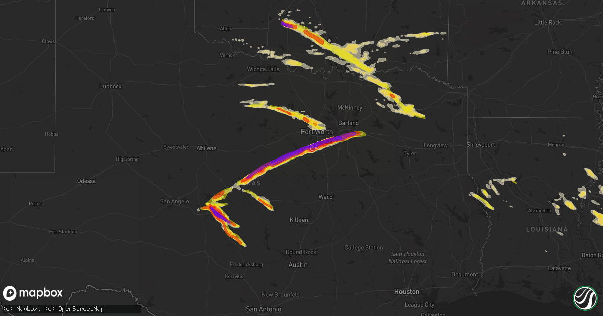
Hail Map on June 12, 2023
Get this storm
June 12 map
$229
one time, instant access
Download today. No call, no setup
Keep the $229
Bought the map and want the full workflow? Apply the entire $229 to a subscription within 7 days. None of it is wasted.
Every map, not just this one
This buys you this map. Subscription and you get every map we run, in the markets you choose from a few cities to whole states to nationwide. Plus real-time alerts the moment a storm fires.
Contact data
Name, contact info, occupancy, even credit band for addresses in the footprint. You go from where it hit to who to call.
Become the source they trust
Unlimited branding weather history reports on demand. You already have the documented answer ready for the property owner, and you are the one who showed up with it.
Property data and RoofTrace estimates
Pull up any address you have got, its value and the exact code rules for that jurisdiction, straight from One Click Code. Then RoofTrace estimates the squares, pitch, and roof value, priced the way you price.
States Impacted by Hail Map on June 12, 2023
Storm reports
New Mexico
| Date | Description |
|---|---|
| 06/12/20232:10 PM CDT | A local report indicates 1.25 inch wind near Maxwell |
| 06/11/20237:34 PM CDT | Report from mping: hen egg |
Florida
| Date | Description |
|---|---|
| 06/12/20231:29 PM CDT | Several reports of hail in bonifay... Some up to quarter size. |
| 06/12/202311:30 AM CDT | Social media report of estimated wind gusts of 50 to 60 mph. |
| 06/12/202311:30 AM CDT | Report of hail up to quarter size in the wacissa area near the leon-jefferson county line. |
| 06/12/20237:30 AM CDT | A few trees and power lines were blown down in western holmes county. |
South Carolina
| Date | Description |
|---|---|
| 06/12/20236:12 PM CDT | Beaufort county warning point reported a tree down at the 300 block of bruce k smalls drive. |
| 06/12/20236:12 PM CDT | Beaufort county warning point reported a tree down at 300 block of wimbee landing road. |
| 06/12/20236:08 PM CDT | Beaufort county warning point reported trees down on clarendon road. |
| 06/12/20236:04 PM CDT | Beaufort county warning point reported a tree down at the intersection of trask parkway and stony creek cemetery road. |
| 06/12/20235:53 PM CDT | Jasper county warning point reported a small tree down at 110 block of step school road. |
| 06/12/20235:47 PM CDT | Jasper county warning point reported a tree down at the intersection of grays highway and stock farm road. |
Colorado
| Date | Description |
|---|---|
| 06/12/20235:45 PM CDT | At least 7 power poles were snapped 2/3rds of the way down. All facing the same direction from straight line winds. |
| 06/12/20234:16 PM CDT | Mostly penny sized... With a few larger stones up to ping pong ball sized. |
| 06/12/20232:30 PM CDT | A local report indicates 2.00 inch wind near 2 WSW Penrose |
| 06/12/20231:53 PM CDT | 1-2 inches of hail covering the roads. |
| 06/12/20231:50 PM CDT | A local report indicates 1.00 inch wind near 2 S Canon City |
| 06/12/20231:47 PM CDT | Report from mping: quarter |
| 06/12/20231:46 PM CDT | Report from mping: quarter |
| 06/12/20231:43 PM CDT | Hail size ranging from 0.75 to 1 inch in diameter. |
| 06/12/20231:38 PM CDT | A local report indicates 2.00 inch wind near 2 ESE Canon City |
| 06/12/20238:35 AM CDT | Cocorahs report. |
Oklahoma
| Date | Description |
|---|---|
| 06/12/20239:20 AM CDT | Damage to several trees and a small greenhouse damaged. |
| 06/12/20239:08 AM CDT | Delayed report. Small tree limbs and powerlines down due to thunderstorm wind. |
| 06/12/20237:30 AM CDT | A local report indicates 1.00 inch wind near Bray |
| 06/12/20237:14 AM CDT | A local report indicates 1.75 inch wind near Marlow |
| 06/12/20237:11 AM CDT | A local report indicates 1.75 inch wind near 5 S Rush Springs |
| 06/12/20237:07 AM CDT | A local report indicates 1.75 inch wind near 4 N Marlow |
Georgia
| Date | Description |
|---|---|
| 06/12/20236:44 PM CDT | Tree down near psc road. |
| 06/12/20235:54 PM CDT | Multiple trees reported down near the intersection of cannon rd and us hwy 280. |
| 06/12/20235:25 PM CDT | Dispatch reported a couple of trees and powerlines down on railroad street. |
| 06/12/20235:24 PM CDT | Quarter sized hail reported near the intersection of cemetery st. And colden isles pkwy. |
| 06/12/20235:20 PM CDT | 911 dispatch reported powerlines down on front street in sylvester. |
| 06/12/20234:47 PM CDT | Spotter reports straight line wind damage to a small shed and aluminum carport. |
| 06/12/20234:35 PM CDT | Tree down on main street. |
| 06/12/20232:05 PM CDT | Milan post office reported quarter sized hail. |
| 06/12/20237:05 AM CDT | Tree limbs blocking 1 of 2 lanes on highway 3 at jackson dairy road. |
Mississippi
| Date | Description |
|---|---|
| 06/12/20236:13 PM CDT | So reports trees down in poplarville. |
| 06/12/20236:12 PM CDT | Tree damage to homes on w mcclendon and s allen in poplarville. Additional trees uprooted and power lines down in the area as well. |
| 06/12/20236:12 PM CDT | Tree damage to home on s. Pine in poplarville. Additional trees uprooted and power lines down in the area as well. |
| 06/12/20236:12 PM CDT | Tree damage to homes on hyde st and n jackson st in poplarville. Additional trees uprooted and power lines down in the area as well. |
| 06/12/20236:00 PM CDT | So reports trees down in crossroads area. |
| 06/12/20236:00 PM CDT | So reports trees down in henleyfield area. |
| 06/12/20235:58 PM CDT | Minor structural damage to home. |
| 06/12/20235:41 PM CDT | Tree downed on brooklyn-janice road. |
| 06/12/20235:41 PM CDT | Tree downed on brooklyn-janice road. |
| 06/12/20235:25 PM CDT | Tree on powerline on old hwy 11 & and hwy 589. |
| 06/12/20235:20 PM CDT | So reports several trees and power lines down in the lexie area. |
| 06/12/20235:09 PM CDT | Tree downed on bay creek and purvis oloh road. |
| 06/12/20235:01 PM CDT | Trees down on power lines along magnolia progress rd. |
| 06/12/20234:57 PM CDT | Tree down on home on west oak st in magnolia. |
| 06/12/20234:53 PM CDT | Tree down near intersection of hwy 24 and i-55. |
| 06/12/20234:39 PM CDT | Tree on a powerline on 82 farve road. |
| 06/12/20234:33 PM CDT | Public report with video of multiple trees down in richton. Time estimated based on radar. |
| 06/12/20233:17 PM CDT | Powerline down at the intersection of rose street and robinson road in jackson ms. |
| 06/12/20233:07 PM CDT | Large tree down on powerline at the intersection of north state street and northside drive reported via twitter. |
| 06/12/20233:02 PM CDT | Tree down on champion hill road in bolton ms. |
| 06/11/20239:40 PM CDT | Tree downed on hwy 589 and ford loop. |
| 06/11/20237:30 PM CDT | Mesonet station ptbm6 petit bois is |
Louisiana
| Date | Description |
|---|---|
| 06/12/20235:53 PM CDT | Bogalusa pd reports tree down near long ave and front st... Also near breland st and ruby rd. |
| 06/12/20235:52 PM CDT | Bogalusa pd reports tree down near west 17th and avenue l. |
| 06/12/20235:25 PM CDT | Tree down on mt. Pisgah rd. |
| 06/12/20235:24 PM CDT | Tree down on bill creel rd. |
| 06/12/20235:19 PM CDT | Tree down on hwy 38 near mt hermon. |
| 06/12/20233:28 PM CDT | Trees and poles down in saint joseph and waterproof via sheriffs office. |
| 06/12/20233:18 PM CDT | Several trees down or twisted off. Power poles and lines down. |
| 06/12/20233:18 PM CDT | Corrects previous tstm wnd dmg report from clarence. Several trees down or twisted off. Power poles and lines down. |
| 06/12/20233:10 PM CDT | A local report indicates 1.00 inch wind near 9 WSW Florien |
| 06/12/20233:05 PM CDT | Quarter size hail fell at the dollar general in clarence. |
| 06/12/20232:18 PM CDT | A local report indicates 1.00 inch wind near Zwolle |
| 06/12/20232:00 PM CDT | Trees and power lines down on hwy 6 between fort jessup and robaline. |
| 06/12/20231:18 PM CDT | Corrects previous tstm wnd dmg report from pleasant hill. Trees and power lines down. |
| 06/12/20231:15 PM CDT | Trees and power lines down. |
Alabama
| Date | Description |
|---|---|
| 06/12/20235:30 PM CDT | Tree down on mccoy road near cottonwood. |
North Carolina
| Date | Description |
|---|---|
| 06/12/20232:42 PM CDT | Multiple trees fell across power lines and on utility equipment in the area between hickory grove and mint hill. |
| 06/12/20232:40 PM CDT | Social media report of multiple trees down in the pence rd area. |
| 06/12/20232:39 PM CDT | Social media picture of trees down on crestside ln. |
| 06/11/20237:35 PM CDT | Corrects previous tstm wnd dmg report from 2 nw forestburg. Tree limbs downed onto a power line off us-17 just south of cartwright swamp road. Numerous power outages re |
Texas
| Date | Description |
|---|---|
| 06/12/20236:44 PM CDT | Tennis ball size hail. |
| 06/12/20236:41 PM CDT | Hen egg size hail. |
| 06/12/20236:40 PM CDT | Hen egg+ size hail. |
| 06/12/20236:32 PM CDT | A local report indicates 1.00 inch wind near 5 SE Millersview |
| 06/12/20236:16 PM CDT | A local report indicates 1.00 inch wind near 2 ESE Millersview |
| 06/12/202312:44 PM CDT | Hail covering the ground. |
| 06/12/202312:24 PM CDT | Golf ball |
| 06/12/202312:12 PM CDT | Corrects previous hail report from 1 sse pampa. Golf ball |
| 06/12/202312:12 PM CDT | A local report indicates 1.25 inch wind near 5 NW Pampa |
| 06/12/202312:10 PM CDT | A local report indicates 1.75 inch wind near 1 NW Pampa |
| 06/12/202312:09 PM CDT | Half dollar |
| 06/12/202312:09 PM CDT | Numerous reports of large hail fell across pampa. The largest size was baseball size hail that fell. Accumulating hail up to golfball size occurred as well. Many cars i |
| 06/12/202311:40 AM CDT | Emergency manager reported a tree caused damage to a home and powerlines near private road 282. Outflow winds are estimated to be around 40-50mph. |
| 06/12/202310:56 AM CDT | Report from sheriff office. |
| 06/12/20236:58 AM CDT | Public reports of quarter size hail in hurst. |
| 06/12/20236:35 AM CDT | Social media reports of ping pong ball size hail near i-35 and heritage trace pkwy. |
| 06/12/20236:20 AM CDT | Social media report of half dollar size hail near bonds ranch & saginaw blvd. |
| 06/12/20236:18 AM CDT | Reports of quarter size hail nw tarrant county near morris-diddo road and peden road. |
| 06/12/20236:15 AM CDT | Social media reports of golf ball size hail in azle. |
| 06/12/20236:12 AM CDT | Trees down along hwy 19 north of tira near the s sulphur river. Time estimated based on radar. |
| 06/12/20236:00 AM CDT | Amateur radio reported of quarter size hail near tms. |
| 06/12/20235:37 AM CDT | Near boonesville. |
| 06/12/20235:30 AM CDT | Honey grove vol. Fire dept reported numerous large tree branches down in the city. |
| 06/12/20234:51 AM CDT | A local report indicates 1.25 inch wind near 6 ENE Bryson |
| 06/12/20234:45 AM CDT | A local report indicates 1.00 inch wind near 6 ENE Bryson |
| 06/11/202311:25 PM CDT | Delayed report: social media report of quarter size hail in forney. |
| 06/11/202311:05 PM CDT | Egg size hail along great trinity forest way and us 175. |
| 06/11/202311:02 PM CDT | A local report indicates 2.00 inch wind near 2 NE Cedar Hill |
| 06/11/202310:49 PM CDT | Report from mping: tennis ball |
| 06/11/202310:47 PM CDT | Report from mping: quarter |
| 06/11/202310:39 PM CDT | Report from mping: tennis ball |
| 06/11/202310:38 PM CDT | Report from mping: hen egg+ |
| 06/11/202310:37 PM CDT | Report from mping: quarter |
| 06/11/202310:36 PM CDT | Social media report of baseball size hail in mansfield. |
| 06/11/202310:36 PM CDT | Social media photo of measured 4 inch hail. |
| 06/11/202310:35 PM CDT | Report from mping: golf ball |
| 06/11/202310:35 PM CDT | Report from mping: baseball |
| 06/11/202310:35 PM CDT | Social media photos of baseball size hail. |
| 06/11/202310:33 PM CDT | Photo passed through from one of our broadcast partners of hail that measured 5 inches. |
| 06/11/202310:33 PM CDT | Report from mping: half dollar |
| 06/11/202310:33 PM CDT | Social media report of measured baseball size hail. |
| 06/11/202310:32 PM CDT | Social media photo of baseball size hail. |
| 06/11/202310:23 PM CDT | Report from mping: golf ball |
| 06/11/202310:21 PM CDT | A local report indicates 1.75 inch wind near 2 S Godley |
| 06/11/202310:19 PM CDT | Report from mping: golf ball |
| 06/11/202310:18 PM CDT | Social media photo of measured 4 inch hail in burleson. |
| 06/11/202310:15 PM CDT | Report from mping: quarter |
| 06/11/202310:14 PM CDT | Report from mping: tennis ball |
| 06/11/202310:06 PM CDT | Ping pong hail in joshua at fm 917 and hwy 174 via hams. |
| 06/11/202310:06 PM CDT | Report from mping: half dollar |
| 06/11/20239:59 PM CDT | Report from mping: hen egg |
| 06/11/20239:59 PM CDT | Golf ball size hail at hwy 171 and 2331 in godley via em. |
| 06/11/20239:56 PM CDT | Spotter in godley reporting slightly larger than quarter hail via hams. |
| 06/11/20239:52 PM CDT | Report from mping: quarter |
| 06/11/20239:50 PM CDT | Golf ball hail on hwy 167 just east of lake granbury via hams. |
| 06/11/20239:47 PM CDT | Report of golf ball to tennis ball to baseball size hail across pecan plantation. |
| 06/11/20239:46 PM CDT | Tennis ball size hail in pecan plantation via hams. |
| 06/11/20239:36 PM CDT | Golf ball size hail south of tolar via hams. |
| 06/11/20239:27 PM CDT | Report from mping: quarter |
| 06/11/20239:24 PM CDT | A local report indicates 1.25 inch wind near 10 E Mason |
| 06/11/20239:23 PM CDT | Report from mping: golf ball |
| 06/11/20239:21 PM CDT | Quarter hail on hwy 205 east of stephenville via hams. |
| 06/11/20239:11 PM CDT | Report from mping: golf ball |
| 06/11/20239:09 PM CDT | Report from mping: ping pong ball |
| 06/11/20239:08 PM CDT | Golf ball hail in heritage hills south of stephenville. |
| 06/11/20239:02 PM CDT | Email report of ping pong ball size hail 4s of stephenville. |
| 06/11/20238:51 PM CDT | Quarter hail in dublin via hams. |
| 06/11/20238:47 PM CDT | A local report indicates 1.25 inch wind near 2 ESE Owens |
| 06/11/20238:44 PM CDT | Tennis ball size hail along highway 16 north of comanche. |
| 06/11/20238:40 PM CDT | A local report indicates 1.75 inch wind near Katemcy |
| 06/11/20238:16 PM CDT | Golf ball to tennis ball size hail falling north of blanket. |
| 06/11/20238:13 PM CDT | Report of golf ball to tennis ball size hail w of comanche. |
| 06/11/20238:12 PM CDT | Tennis ball. |
| 06/11/20237:56 PM CDT | Corrects time. |
| 06/11/20237:55 PM CDT | A local report indicates 1.75 inch wind near 3 SSE Brady |
| 06/11/20237:54 PM CDT | A local report indicates 1.75 inch wind near Owens |
| 06/11/20237:54 PM CDT | A local report indicates 1.75 inch wind near Owens |
| 06/11/20237:53 PM CDT | A local report indicates 1.50 inch wind near 1 SSW Brady |
| 06/11/20237:45 PM CDT | A local report indicates 1.00 inch wind near 1 SSW Brady |
| 06/11/20237:42 PM CDT | A local report indicates 1.00 inch wind near 1 SSW Brady |
| 06/11/20237:42 PM CDT | Half dollar size hail. |
| 06/11/20237:35 PM CDT | A local report indicates 2.75 inch wind near Brady |
| 06/11/20237:29 PM CDT | Baseball size hail reported. |
| 06/11/20237:26 PM CDT | A local report indicates 1.75 inch wind near 7 E Melvin |
Cities Impacted by Hail Map on June 12, 2023
- Rush Springs, OK
- Marlow, OK
- Foster, OK
- Lindsay, OK
- Duncan, OK
- Elmore City, OK
- Hennepin, OK
- Tussy, OK
- Davis, OK
- Springer, OK
- Tupelo, MS
- Verona, MS
- Plantersville, MS
- Fulton, MS
- Etta, MS
- Thaxton, MS
- Oxford, MS
- New Albany, MS
- Pontotoc, MS
- Ecru, MS
- Ardmore, OK
- Mill Creek, OK
- Mannsville, OK
- Madill, OK
- Tishomingo, OK
- Sulphur, OK
- Durant, OK
- Milburn, OK
- Kenefic, OK
- Mead, OK
- Pueblo, CO
- Salida, CO
- Vega, TX
- Channing, TX
- Masterson, TX
- Dumas, TX
- Sunray, TX
- Stinnett, TX
- Pampa, TX
- Monticello, FL
- Fritch, TX
- Borger, TX
- Mobeetie, TX
- Skellytown, TX
- Miami, TX
- Wheeler, TX
- Canadian, TX
- Boulder, CO
- Nederland, CO
- Cotopaxi, CO
- Fletcher, OK
- Bokchito, OK
- Rye, CO
- Thomasville, GA
- Ninnekah, OK
- Cement, OK
- Caney, OK
- Caddo, OK
- Commerce, TX
- Pauls Valley, OK
- Folsom, NM
- Branson, CO
- Raton, NM
- Bennington, OK
- Boswell, OK
- Coleman, OK
- Beulah, CO
- Cyril, OK
- Chickasha, OK
- Morrison, CO
- Littleton, CO
- Durham, OK
- Colorado Springs, CO
- Pelican, LA
- Cumby, TX
- Campbell, TX
- Alex, OK
- Maysville, OK
- Tallahassee, FL
- Conifer, CO
- Howard, CO
- Ratliff City, OK
- Wynnewood, OK
- Calera, OK
- Canon City, CO
- Fountain, CO
- Eldorado Springs, CO
- Maxwell, NM
- Noble, LA
- Penrose, CO
- Florence, CO
- Zwolle, LA
- Milam, TX
- Rhine, GA
- Milan, GA
- Bonifay, FL
- Wagon Mound, NM
- Many, LA
- Florien, LA
- Roy, NM
- Jonesville, LA
- Monterey, LA
- Gloster, MS
- Woodville, MS
- Crosby, MS
- Centreville, MS
- Ryan, OK
- Nocona, TX
- Ringling, OK
- Conchas Dam, NM
- Mosquero, NM
- Summit, MS
- Mccomb, MS
- Magnolia, MS
- Liberty, MS
- Tylertown, MS
- Franklinton, LA
- Kentwood, LA
- Osyka, MS
- Mount Hermon, LA
- Angie, LA
- Bogalusa, LA
- Chauncey, GA
- Nara Visa, NM
- Paint Rock, TX
- Eden, TX
- Millersview, TX
- Doole, TX
- Lohn, TX
- Melvin, TX
- Peyton, CO
- Haswell, CO
- Guffey, CO
- Collinston, LA
- Garrett, WY
- Frederick, OK
- Seminary, MS
- Sumrall, MS
- Jayess, MS
- Shelbyville, TX
- Karval, CO
- Hugo, CO
- Calhan, CO
- Healdton, OK
- Wilson, OK
- Ramah, CO
- Evergreen, AL
- Andalusia, AL
- Pleasant Hill, LA
- Campti, LA
- Simla, CO
- Monticello, MS
- Oak Vale, MS
- Doerun, GA
- Moultrie, GA
- Rayville, LA
- Belmont, LA
- Converse, LA
- Marthaville, LA
- Robeline, LA
- Raleigh, MS
- Albany, GA
- Leesburg, GA
- Newellton, LA
- Saint Joseph, LA
- Lorman, MS
- Flagler, CO
- Arriba, CO
- Limon, CO
- Matheson, CO
- Fitzgerald, GA
- Eads, CO
- Vidalia, LA
- Ferriday, LA
- Natchez, MS
- Waurika, OK
- Henrietta, TX
- Clayton, LA
- Dawson, GA
- Baconton, GA
- Camilla, GA
- Holliday, TX
- Archer City, TX
- Scotland, TX
- Windthorst, TX
- Genoa, CO
- Bronwood, GA
- Sale City, GA
- Richton, MS
- Ovett, MS
- Glenwood, GA
- Soperton, GA
- Jamesville, NC
- Plymouth, NC
- Randlett, OK
- Wichita Falls, TX
- Byers, TX
- Temple, OK
- Coleman, GA
- Smithdale, MS
- Wilmer, AL
- Jena, LA
- Arlington, CO
- Carson, MS
- Dublin, GA
- Leakesville, MS
- Sugar City, CO
- Cuthbert, GA
- Shellman, GA
- Walters, OK
- Fort Gaines, GA
- Silver Creek, MS
- Tipton, OK
- Des Moines, NM
- Effie, LA
- Roper, NC
- Springer, NM
- Cimarron, NM
- Newton, GA
- Fayette, MS
- Union Church, MS
- Abbeville, GA
- McRae Helena, GA
- Rochelle, GA
- Pitts, GA
- Rockvale, CO
- Roxie, MS
- Meadville, MS
- Coushatta, LA
- Goldonna, LA
- Natchitoches, LA
- Devol, OK
- Bassfield, MS
- Hollister, OK
- Hemphill, TX
- San Augustine, TX
- Elk City, OK
- Chester, GA
- Eastman, GA
- Hattiesburg, MS
- Ellisville, MS
- Creswell, NC
- Williamston, NC
- Loveland, OK
- Rockledge, GA
- East Dublin, GA
- State Line, MS
- Leary, GA
- Damascus, GA
- Foxworth, MS
- Columbia, MS
- Citronelle, AL
- Cadwell, GA
- Okeechobee, FL
- Castleberry, AL
- Donalsonville, GA
- Deville, LA
- Marksville, LA
- Chunchula, AL
- Prentiss, MS
- Collins, GA
- Evergreen, LA
- Morrow, LA
- Plaucheville, LA
- Coolidge, GA
- Ochlocknee, GA
- Cairo, GA
- Petal, MS
- Stantonsburg, NC
- Voss, TX
- Coleman, TX
- Gouldbusk, TX
- Rockwood, TX
- Brady, TX
- Santa Anna, TX
- Bangs, TX
- Model, CO
- Trinidad, CO
- Rochelle, TX
- Logan, NM
- Brownwood, TX
- May, TX
- Early, TX
- Blanket, TX
- Sidney, TX
- Comanche, TX
- Voca, TX
- Kim, CO
- Mason, TX
- De Leon, TX
- Dublin, TX
- San Saba, TX
- Stephenville, TX
- Art, TX
- Zephyr, TX
- Mullin, TX
- Goldthwaite, TX
- Bluff Dale, TX
- Tolar, TX
- Glen Rose, TX
- Castell, TX
- Granbury, TX
- Cleburne, TX
- Rainbow, TX
- Godley, TX
- Joshua, TX
- Lometa, TX
- San Jon, NM
- Burleson, TX
- Alvarado, TX
- Llano, TX
- Mansfield, TX
- Lillian, TX
- Venus, TX
- Crowley, TX
- Fort Worth, TX
- Midlothian, TX
- Cedar Hill, TX
- Grand Prairie, TX
- Red Oak, TX
- Desoto, TX
- Arlington, TX
- Duncanville, TX
- Dallas, TX
- Lancaster, TX
- Hutchins, TX
- Ferris, TX
- Wilmer, TX
- Seagoville, TX
- Balch Springs, TX
- Forney, TX
- Crandall, TX
- Mesquite, TX
- Sunnyvale, TX
- Kaufman, TX
- Terrell, TX
- Hico, TX
- Pachuta, MS
- Waynesboro, MS
- Sneads, FL
- Eunice, LA
- Atmore, AL
- Pineland, SC
- Garnett, SC
- Repton, AL
- Range, AL
- Brewton, AL
- Elgin, OR
- Uriah, AL
- Grove Hill, AL
- Ruth, MS
- Bush, LA
- Brooklyn, MS
- New Augusta, MS
- Pass Christian, MS
- Diamondhead, MS
- Kiln, MS
- Sandy Hook, MS
- Poplarville, MS
- Ashford, AL
- Pansey, AL
- Wiggins, MS
- Laurel, MS
- Mount Olive, MS
- Collins, MS
- Pritchett, CO
- Lumberton, MS
- Bascom, FL
- Gordon, AL
- Cottonwood, AL
- Shorterville, AL
- Edison, GA
- Bluffton, GA
- Heidelberg, MS
- Perkinston, MS
- McHenry, MS
- Burneyville, OK
- Leon, OK
- Jakin, GA
- Blakely, GA
- Malone, FL
- Buckatunna, MS
- Fort Stewart, GA
- Deer Park, AL
- Ozark, AL
- Skipperville, AL
- Morven, GA
- Dothan, AL
- Columbia, AL
- Sylvester, GA
- Myrtle Beach, SC
- Lucedale, MS
- Semmes, AL
- Eight Mile, AL
- Wadmalaw Island, SC
- Johns Island, SC
- Norwood, LA
- Purvis, MS
- Moselle, MS
- Abbeville, AL
- Shubuta, MS
- Picayune, MS
- Hertford, NC
- Monroeville, AL
- Frisco City, AL
- Murfreesboro, NC
- Millry, AL
- Carriere, MS
- Louin, MS
- Savannah, GA
- Bloomingdale, GA
- Pooler, GA
- Newcastle, TX
- Graham, TX
- Olney, TX
- Loving, TX
- Mcarthur, CA
- Tyrone, OK
- Hugoton, KS
- Rolla, KS
- Ariton, AL
- Lone Grove, OK
- Clio, AL
- Clopton, AL
- Brundidge, AL
- Cartwright, OK
- Louisville, AL
- Clayton, AL
- Guymon, OK
- Wapanucka, OK
- Keene, TX
- Kingston, OK
- Jacksboro, TX
- Bryson, TX
- Perrin, TX
- Windom, TX
- Honey Grove, TX
- Petty, TX
- Roxton, TX
- Bridgeport, TX
- Paradise, TX
- Poolville, TX
- Springtown, TX
- Cooper, TX
- Ben Franklin, TX
- Boyd, TX
- Azle, TX
- Enloe, TX
- Sulphur Springs, TX
- Newark, TX
- Smithville, OK
- Honobia, OK
- Dike, TX
- Saltillo, TX
- Pickton, TX
- Mount Vernon, TX
- Haslet, TX
- Scroggins, TX
- Leesburg, TX
- Pittsburg, TX
- Mount Pleasant, TX
- Haltom City, TX
- North Richland Hills, TX
- Winnsboro, TX
- Hurst, TX
- Bedford, TX
- Avondale, CO
- Wolfe City, TX
- Walsenburg, CO
- Atoka, OK
- Lane, OK
- Hendrix, OK
- Klondike, TX
- Nashoba, OK
- Keyes, OK
- Colbert, OK
- Telephone, TX
- Ivanhoe, TX
- Dodd City, TX
- Bonham, TX
- Ravenna, TX
- Antlers, OK
- Ringold, OK
- Valliant, OK
- Stringtown, OK
- Watson, OK
- Finley, OK
- Colorado City, CO
- Ladonia, TX
- Pecan Gap, TX
- Clayton, OK
- Fort Towson, OK
- Snow, OK
- Garland, TX
- Jermyn, TX
- Rhome, TX
- Rattan, OK
- Moyers, OK
- Lake Creek, TX
- Decatur, TX
- Dougherty, OK
- Sumner, TX
- Como, TX
- Bethel, OK
- Brookston, TX
- Sulphur Bluff, TX
- Marietta, OK
- Denison, TX
- Pottsboro, TX
- Keller, TX
- Euless, TX
- Colleyville, TX
- Naval Air Station Jrb, TX
- Greenwood, FL