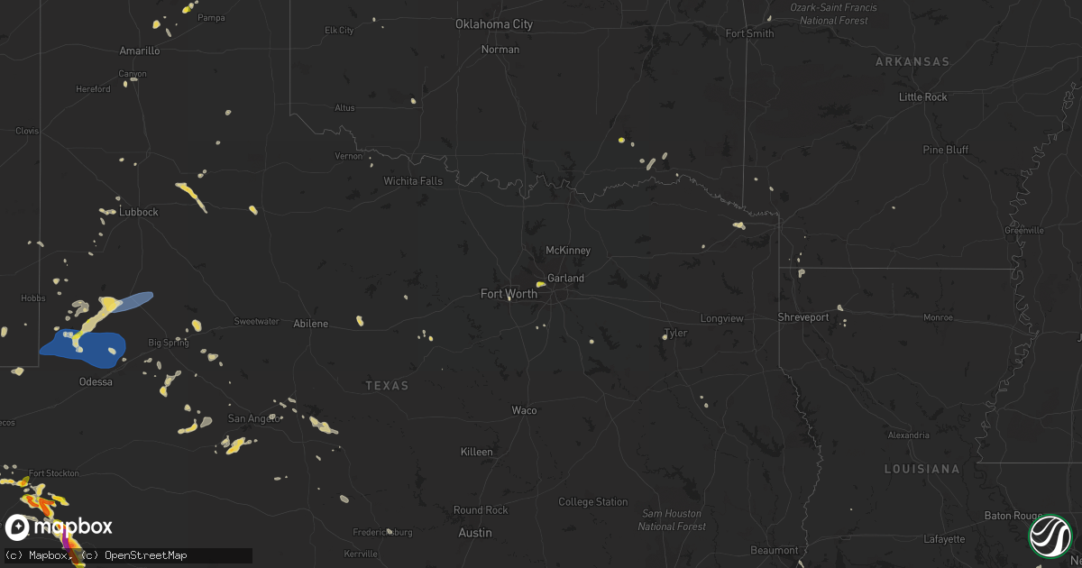
Hail Map on June 7, 2023
Get this storm
June 7 map
$229
one time, instant access
Download today. No call, no setup
Keep the $229
Bought the map and want the full workflow? Apply the entire $229 to a subscription within 7 days. None of it is wasted.
Every map, not just this one
This buys you this map. Subscription and you get every map we run, in the markets you choose from a few cities to whole states to nationwide. Plus real-time alerts the moment a storm fires.
Contact data
Name, contact info, occupancy, even credit band for addresses in the footprint. You go from where it hit to who to call.
Become the source they trust
Unlimited branding weather history reports on demand. You already have the documented answer ready for the property owner, and you are the one who showed up with it.
Property data and RoofTrace estimates
Pull up any address you have got, its value and the exact code rules for that jurisdiction, straight from One Click Code. Then RoofTrace estimates the squares, pitch, and roof value, priced the way you price.
States Impacted by Hail Map on June 7, 2023
Storm reports
Georgia
| Date | Description |
|---|---|
| 06/07/20236:00 PM CDT | Multiple trees fell on shibar dr... Including one that fell onto a house. Time estimated. |
| 06/07/20235:56 PM CDT | Tree down on hills mill pond rd. Time estimated. |
| 06/07/20235:56 PM CDT | Updates previous tstm wnd dmg report from 3 e vidette for additional damage description. Tree down on hills mill pond rd which took down powerlines. Time estimated. |
| 06/07/20235:48 PM CDT | Tree down on college ave in vidette. Exact location not given. Time estimated. |
| 06/07/20235:48 PM CDT | Updates previous tstm wnd dmg report from vidette for additional damage description from emergency manager. Tree down on south college ave near vidette... Ga which took |
| 06/07/20235:12 PM CDT | Trees down on hwy 257 near friendship church road. |
| 06/07/20235:00 PM CDT | Updates previous tstm wnd dmg report from 1 ene midville with additional damage description from emergency manager. Tree down at ralph smith rd and henry rowland rd... |
| 06/07/20235:00 PM CDT | Tree down at ralph smith rd and henry rowland rd... Ne of midville. Time estimated. |
| 06/07/20234:58 PM CDT | Trees down near mile marker 115 on i-75 north. |
| 06/07/20234:49 PM CDT | Trees down at intersection of clark street and railroad avenue. |
| 06/07/20234:48 PM CDT | Trees down along oneil road near the forest chapel road intersection. |
| 06/07/20234:07 PM CDT | Trees down at intersection of vienna road and milford street. |
| 06/07/20234:05 PM CDT | Tree down at the intersection of s highway 241 and arena road. |
| 06/07/20234:05 PM CDT | Corrects previous tstm wnd dmg report from 1 wnw kathleen. Tree and powerlines down across s old perry road near hwy 127. |
| 06/07/20233:59 PM CDT | Tree on house on silk tree trace near the intersection of red maple trail. |
| 06/07/20233:54 PM CDT | Tree on house on coopers mill near the intersection of n lake drive. |
| 06/07/20233:54 PM CDT | Corrects previous tstm wnd dmg report from 4 wnw houston lake. Tree and powerline down across s highway 41 near alpine valley dr. |
| 06/07/20233:54 PM CDT | Tree and powerline down across s highway 41 near alpine valley dr. |
| 06/07/20233:46 PM CDT | Trees down on south martin luther king jr. Blvd near old dawson road. |
| 06/07/20232:38 PM CDT | Trained spotter reports that a microburst occurred near mile marker 6 on interstate 16. Trees down on both sides of the interstate with cars pulled off to the side. |
| 06/07/20232:37 PM CDT | Trees and powerlines down on little briar creek church road near ricketson road. |
| 06/07/20232:37 PM CDT | Trees and powerlines down at ricketson road near mt. Pleasant road. |
| 06/07/20232:00 PM CDT | Large tree branch down near the intersection of ga-208 and ga-315. |
Oklahoma
| Date | Description |
|---|---|
| 06/07/20236:55 PM CDT | A local report indicates 1.00 inch wind near Lane |
Iowa
| Date | Description |
|---|---|
| 06/07/20233:57 AM CDT | Grain bin and large trees damaged by thunderstorm winds. Winds estimated at 60 mph. |
North Dakota
| Date | Description |
|---|---|
| 06/07/20236:20 PM CDT | Large trees snapped a couple feet above the ground: picture via twitter. |
| 06/07/20235:50 PM CDT | Semi blown over. |
| 06/07/20235:46 PM CDT | Semi blown off the road. |
| 06/07/20234:40 PM CDT | Uprooted trees. Large 8 inch tree branches on road. Seven large trees down. |
| 06/07/20234:40 PM CDT | Just west of argusville report of golf ball size hail from broadcast media. |
| 06/07/20234:13 PM CDT | Heavy crop damage to corn from strong winds and possibly hail. |
| 06/07/20233:58 PM CDT | Report of nickel to quarter size hail by sheriff deparment. |
| 06/07/20233:35 PM CDT | Law enforcement relayed report of windshield damage to vehicle from quarter size hail. |
| 06/07/20233:13 PM CDT | Corrects previous tstm wnd dmg report from 4 sw logan center. Heavy crop damage to corn from strong winds and possibly hail. |
| 06/06/20239:20 PM CDT | Mesonet station 320949 6 sse roth |
Arkansas
| Date | Description |
|---|---|
| 06/07/20235:20 PM CDT | Several large tree limbs down in black oak. Pictures relayed via social media. Time estimated from radar. |
Nebraska
| Date | Description |
|---|---|
| 06/06/202310:24 PM CDT | Several large trees snapped. Minor roof damage to a couple of houses. Winds estimated at 60 mph. |
South Dakota
| Date | Description |
|---|---|
| 06/06/20238:35 PM CDT | Awos station k8d3 2 e sisseton. |
| 06/06/20238:22 PM CDT | Mesonet station 2 lake city |
Texas
| Date | Description |
|---|---|
| 06/07/20236:01 PM CDT | Report from mping: ping pong ball |
| 06/07/20235:56 PM CDT | Quarter to golf ball size hail. |
| 06/07/20235:54 PM CDT | Report from mping: quarter |
| 06/07/20235:40 PM CDT | A local report indicates 2.00 inch wind near Van Horn |
| 06/07/20235:35 PM CDT | 2 inch diameter hail observed on the south side of balmorhea. |
| 06/07/20235:24 PM CDT | Ping pong ball sized hail observed along i-10 near balmorhea. |
| 06/07/20234:25 PM CDT | A local report indicates 1.50 inch wind near 15 N Hovey |
| 06/07/20236:50 AM CDT | Public relayed via social media that rv jack was bent... And trailer pushed back about 2 feet due to thunderstorm winds. Time approximated by radar. |
| 06/07/20231:23 AM CDT | A local report indicates 59 MPH wind near Laughlin AFB |
| 06/06/202311:34 PM CDT | Mesonet station ur103 2.2 e colorado city |
| 06/06/202311:32 PM CDT | Reports of a large tree blown down onto a vehicle and damage to the roof of an outbuilding just north of colorado city. Time estimated from radar and nearby observation |
| 06/06/202311:11 PM CDT | Mesonet station 31 fluvanna 3w. |
| 06/06/202310:42 PM CDT | Mesonet station 77 1sse lomax lomax/howard county. |
| 06/06/202310:10 PM CDT | Mesonet station 18 lamesa 2se. |
| 06/06/20239:55 PM CDT | Mesonet station 84 2wnw tarzan tarzan/martin county. |
| 06/06/20239:19 PM CDT | Mesonet station 48 2e andrewsw. |
| 06/06/20239:06 PM CDT | Mesonet station 72 big bend np/brewster county. |
| 06/06/20238:21 PM CDT | Report from mping: quarter |
| 06/06/20237:58 PM CDT | A local report indicates 2.00 inch wind near 2 WNW Longfellow |
| 06/06/20237:54 PM CDT | A local report indicates 1.75 inch wind near 3 WNW Longfellow |
| 06/06/20237:25 PM CDT | Delayed report. Social media report of downed tree limbs along meadow creek dr in irving. Time estimated by radar. |
Florida
| Date | Description |
|---|---|
| 06/07/20234:27 PM CDT | The klee asos measured a 58 mph/50 kt wind gust from the southwest. |
| 06/07/20234:20 PM CDT | Trained spotter reports possible tornado damage near skylark blvd and south patrick dr. Extending east to flamingo dr. Damage to carports and roofs of multiple homes. A |
| 06/07/20233:59 PM CDT | The kxmr asos measured a 61 mph/53 kt wind gust from the west-northwest. |
South Carolina
| Date | Description |
|---|---|
| 06/07/20236:52 PM CDT | 2 trees down along ponderosa drive in yemassee. |
| 06/07/20236:11 PM CDT | 1 tree down on cemetery rd near hwy 278. |
| 06/07/20236:09 PM CDT | 2 trees down on wade hampton rd between mcdill rd and 363. |
| 06/07/20236:00 PM CDT | A tree or large limb down on a power line along hwy 601 n just south of hampton sc. |
| 06/07/20235:40 PM CDT | A member of the public reported a large oak tree uprooted along red house road. |
| 06/07/20235:35 PM CDT | A 911 call center relayed a report of a tree down along the 3500 block of blanding dr. Time was estimated via radar data. |
| 06/07/20234:40 PM CDT | 3 trees down blocking roadway on castle hall rd. |
| 06/07/20233:54 PM CDT | Trees and down at atomic rd and double springs rd... Between beech island and jackson. Time estimated. |
| 06/07/20233:53 PM CDT | Tree down on interstate 26 eastbound at or near mile marker 161. Time estimated. |
| 06/07/20233:45 PM CDT | Tree down on oliver st in bowman. Time estimated. |
| 06/07/20233:30 PM CDT | Orangeburg county emergency manager reported damage to structures surrounding a home near the intersection of bay rd and bethel forest rd. Photos of the damage were sup |
| 06/07/20233:30 PM CDT | Orangeburg co emergency manager reported around 20 trees knocked down in rowesville and vicinity... From cannon bridge rd and river dr east to the town of rowesville. N |
| 06/07/20233:26 PM CDT | Trees and power lines down at cannon bridge rd and river dr. Time estimated. |
| 06/07/20233:26 PM CDT | Trees and power lines down at cannon bridge rd and carver school rd. Time estimated. |
| 06/07/20233:16 PM CDT | Trees and power lines down at bamberg rd |
| 06/07/20233:12 PM CDT | Trees and power lines down at shillings bridge rd and ferndale rd. Time estimated. |
| 06/06/20238:08 PM CDT | 2 trees down on lands end rd. A vehicle struck one of the downed trees. |
| 06/06/20238:08 PM CDT | A 911 call center relayed a report of a tree down blocking the roadway on pumpkin hill rd near betsy kerrison pkwy. Time was estimated via radar data. |
| 06/06/20237:53 PM CDT | A 911 call center relayed a report of 3 trees down in roadway along castle rock rd near clearwater way. Time was estimated via radar data. |
| 06/06/20237:09 PM CDT | One tree down at the 2000 block of bennetts point rd... Blocking both lanes. |
Idaho
| Date | Description |
|---|---|
| 06/07/20236:43 PM CDT | Tree down on park center and highland blocking several lanes. |
| 06/07/20236:30 PM CDT | Large tree branches down 2 blocks s of bsu campus. |
| 06/07/20236:28 PM CDT | Mesonet station tt289 crestline trail. |
| 06/07/20236:25 PM CDT | A local report indicates 58 MPH wind near 1 SW Boise |
| 06/07/20236:25 PM CDT | Numerous trees down. Social media reports showing a tree on a house and a tree down on power lines. Numerous power outages. |
Colorado
| Date | Description |
|---|---|
| 06/07/20235:47 PM CDT | Mesonet station co118 070e051 beaver tail tunnel. |
Utah
| Date | Description |
|---|---|
| 06/07/20235:50 PM CDT | Sr-30 mesonet site |
| 06/07/20235:00 PM CDT | Murrays hill mesonet site |
Cities Impacted by Hail Map on June 7, 2023
- Larimore, ND
- Niagara, ND
- Northwood, ND
- Aneta, ND
- Sharon, ND
- Finley, ND
- Luverne, ND
- Hope, ND
- Fort Davis, TX
- Fort Stockton, TX
- Balmorhea, TX
- Argusville, ND
- Gardner, ND
- Hays, MT
- Valentine, TX
- Jordan, MT
- Richland, MT
- Hinsdale, MT
- Casper, WY
- Hatton, ND
- Lakeview, TX
- Crosbyton, TX
- Lewistown, MT
- Grass Range, MT
- Floydada, TX
- West Fork, AR
- Fayetteville, AR
- Whitetail, MT
- West Fargo, ND
- Mapleton, ND
- Harwood, ND
- Ashland, MO
- Stephenville, TX
- Golden, CO
- Unadilla, GA
- Lloyd, MT
- Kaycee, WY
- Franklin, MO
- Boonville, MO
- Opheim, MT
- Chandler, TX
- Tyler, TX
- Flint, TX
- Junction City, GA
- Horatio, AR
- Hartsburg, MO
- Larslan, MT
- Matador, TX
- Arthur, ND
- Thomson, GA
- Stapleton, GA
- Fort Benning, GA
- Columbus, GA
- Jordan Valley, OR
- Cameron, SC
- Havre, MT
- New Boston, TX
- De Kalb, TX
- Seiling, OK
- Fort Valley, GA
- Musselshell, MT
- Waverly Hall, GA
- Talbotton, GA
- Box Springs, GA
- Fargo, OK
- Oriska, ND
- Valley City, ND
- Andrews, SC
- Jamestown, SC
- Umatilla, FL
- Altoona, FL
- Pawleys Island, SC
- Stanford, MT
- Cecil, AL
- Pike Road, AL
- Warrenton, GA
- Spearfish, SD
- Worden, MT
- Alma, AR
- Ragley, LA
- Vienna, GA
- Georgetown, SC
- Canton, OK
- Dora, MO
- Bushnell, FL
- Orangeburg, SC
- Saint Matthews, SC
- Jackson, SC
- Alto, TX
- Hugo, OK
- Cordova, SC
- Rowesville, SC
- McClellanville, SC
- Midland, GA
- Colorado Springs, CO
- Harlem, MT
- Kathleen, GA
- Perry, GA
- Plain Dealing, LA
- Lodge Grass, MT
- Decker, MT
- Petersburg, ND
- Tarpley, TX
- Medina, TX
- Caddo, TX
- Shepherd, MT
- Ponchatoula, LA
- Fort Towson, OK
- Lockesburg, AR
- Hawkinsville, GA
- Douglass, TX
- Combs, AR
- Roundup, MT
- Amenia, ND
- Alcova, WY
- Cope, SC
- Bamberg, SC
- Branchville, SC
- Dubberly, LA
- Heflin, LA
- Atoka, OK
- Lane, OK
- Irving, TX
- Dallas, TX
- Andrews, TX
- Marathon, TX
- Skellytown, TX
- Gardendale, TX
- Midland, TX
- Odessa, TX
- Stanton, TX
- Tarzan, TX
- Lamesa, TX
- Ackerly, TX
- Gail, TX
- Medford, OR
- Volborg, MT
- Miles City, MT
- Brusett, MT
- Edisto Island, SC
- Van Horn, TX
- Lake Wilson, MN
- Roy, MT
- Sand Springs, MT
- Carlsbad, NM
- Green Pond, SC
- Cohagen, MT
- Kermit, TX
- Ballantine, MT
- Pompeys Pillar, MT
- Otter, MT
- Forest Grove, MT
- Mentone, TX
- Shallowater, TX
- Saint James, LA
- Garden City, TX
- Rattan, OK
- Spencerville, OK
- Varnville, SC
- Walcott, ND
- Kindred, ND
- Loving, NM
- Jal, NM
- Levelland, TX
- Lubbock, TX
- Leonard, ND
- Sierra Blanca, TX
- Davisboro, GA
- Adams Run, SC
- Lawton, OK
- Seminole, TX
- Boswell, OK
- Soper, OK
- Huger, SC
- Hollywood, SC
- Cisco, TX
- Moran, TX
- Winnett, MT
- Waynesboro, GA
- Louisville, GA
- Tatum, NM
- Wyndmere, ND
- Rosebud, MT
- Estherville, IA
- Wallingford, IA
- Custer, MT
- Bighorn, MT
- Forsyth, MT
- Corn, OK
- Lidgerwood, ND
- Veblen, SD
- Brownfield, TX
- Baird, TX
- Hysham, MT
- Davenport, ND
- Thibodaux, LA
- Jamestown, LA
- Minden, LA
- Sibley, LA
- Midlothian, TX
- Bradley, AR
- Beaufort, SC
- Ridgeland, SC
- Lake Preston, SD
- Doddridge, AR
- Sandersville, GA
- Smyer, TX
- Clinton, OK
- Ropesville, TX
- Sterling City, TX
- Big Lake, TX
- Dublin, TX
- Verona, ND
- Yemassee, SC
- Early Branch, SC
- Columbia, MS
- Sumrall, MS
- Hattiesburg, MS
- Harrold, TX
- Savannah, GA
- Meadow, TX
- Fort Worth, TX
- Port Wentworth, GA
- Hannaford, ND
- Spur, TX
- Plains, TX
- Hardeeville, SC
- Seagraves, TX
- Seabrook, SC
- Pembroke, GA
- Ellabell, GA
- Hale Center, TX
- Welch, TX
- Mount Pleasant, TX
- Lincoln, MT
- Turner, MT
- Boulder, CO
- Fortson, GA
- Dryden, TX
- Labadieville, LA
- Anton, TX
- Christoval, TX
- Westbrook, TX
- Mertzon, TX
- Malta, MT
- Graettinger, IA
- Big Timber, MT
- Robert Lee, TX
- Sisseton, SD
- Electra, TX
- Claire City, SD
- Big Spring, TX
- Borger, TX
- Medicine Park, OK
- Oakwood, OK
- Menard, TX
- Fort McKavett, TX
- Coahoma, TX
- Tucumcari, NM
- Eldorado, TX
- San Angelo, TX
- Happy, TX
- Canyon, TX
- Slayton, MN
- Eden, TX
- Lohn, TX
- Panhandle, TX
- Rowena, TX
- Miles, TX
- Lake Arthur, NM
- Artesia, NM
- Millersview, TX
- Mirando City, TX
- Doole, TX
- Mason, TX
- Fredericksburg, TX
- Harris, IA
- Lake Park, IA
- Round Lake, MN
- Paint Rock, TX
- Ballinger, TX
- Del Rio, TX
- Brady, TX
- Mereta, TX
- Laredo, TX
- Bruni, TX