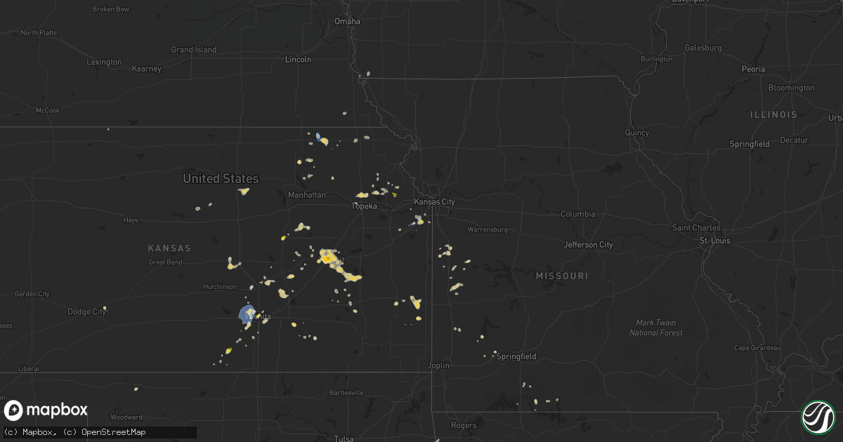
Hail Map on June 5, 2023
Get this storm
June 5 map
$229
one time, instant access
Download today. No call, no setup
Keep the $229
Bought the map and want the full workflow? Apply the entire $229 to a subscription within 7 days. None of it is wasted.
Every map, not just this one
This buys you this map. Subscription and you get every map we run, in the markets you choose from a few cities to whole states to nationwide. Plus real-time alerts the moment a storm fires.
Contact data
Name, contact info, occupancy, even credit band for addresses in the footprint. You go from where it hit to who to call.
Become the source they trust
Unlimited branding weather history reports on demand. You already have the documented answer ready for the property owner, and you are the one who showed up with it.
Property data and RoofTrace estimates
Pull up any address you have got, its value and the exact code rules for that jurisdiction, straight from One Click Code. Then RoofTrace estimates the squares, pitch, and roof value, priced the way you price.
States Impacted by Hail Map on June 5, 2023
Storm reports
Missouri
| Date | Description |
|---|---|
| 06/05/20231:23 PM CDT | 8 inch diameter tree limbs brought down by thunderstorm winds. |
Nevada
| Date | Description |
|---|---|
| 06/04/20237:03 PM CDT | Mesonet station rbvn2 ruby valley raws station elevation: 6899 ft. |
Oklahoma
| Date | Description |
|---|---|
| 06/05/20233:15 PM CDT | Delayed report. Large carport lifted and heavily damaged by thunderstorm wind. Time estimated via radar. |
| 06/05/20233:13 PM CDT | Delayed report. Report from mping: quarter |
Montana
| Date | Description |
|---|---|
| 06/04/20238:19 PM CDT | Images sent to office of hail compared to coins. |
Georgia
| Date | Description |
|---|---|
| 06/05/20234:52 PM CDT | Report of hail ranging in size up to the size of quarters. |
| 06/05/20234:45 PM CDT | 1 inch hail reports at ellison street and roper drive. |
Arkansas
| Date | Description |
|---|---|
| 06/05/20236:00 PM CDT | Multiple trees were reported blown down by thunderstorms yesterday. |
| 06/05/20235:40 PM CDT | A few trees down. |
| 06/05/20235:30 PM CDT | Large tree limbs down east of tyronza. Observer estimates wind |
| 06/05/20235:30 PM CDT | Large tree limbs down east of tyronza. Observer estimates wind greater than 60 mph. |
| 06/05/20235:17 PM CDT | Large tree limbs also downed due to high winds. |
| 06/05/20235:08 PM CDT | A local report indicates 1.25 inch wind near Washburn |
| 06/05/20235:00 PM CDT | Several trees down in the wilson area. |
| 06/05/20235:00 PM CDT | Multiple trees were reported blown down by thunderstorms yesterday. |
| 06/05/20234:56 PM CDT | Photo of ping-pong ball sized hail in wilson. |
| 06/05/20234:50 PM CDT | Multiple trees were reported blown down by thunderstorms yesterday. |
| 06/05/20233:26 PM CDT | An outbuilding was blown across the highway into a grove of trees. Portions of the roofing material knocked trees and a powerline down on the opposite side of the stree |
Kansas
| Date | Description |
|---|---|
| 06/05/20236:00 PM CDT | A local report indicates 1.00 inch wind near 5 W Emporia |
| 06/05/20235:48 PM CDT | A local report indicates 1.50 inch wind near 3 W Emporia |
| 06/05/20235:47 PM CDT | A local report indicates 1.00 inch wind near 6 N Wells |
| 06/05/20235:30 PM CDT | A local report indicates 1.00 inch wind near 5 NNW Olpe |
| 06/05/20235:15 PM CDT | Tree damage over roadways and a stop sign was blown over in burlington. |
| 06/05/20234:57 PM CDT | Pea sized hail also reported. |
| 06/05/20234:50 PM CDT | Mostly pea to nickel size. |
| 06/05/20234:39 PM CDT | Observed by fire chief and relayed by em. |
| 06/05/20233:44 PM CDT | A local report indicates 60 MPH wind near Olathe |
| 06/05/20233:35 PM CDT | A local report indicates 1.00 inch wind near 4 W Stanley |
| 06/05/20233:30 PM CDT | A local report indicates 60 MPH wind near 5 NE Halstead |
| 06/05/20233:22 PM CDT | Corrects previous tstm wnd gst report from 1 ne gardner. |
| 06/05/20233:22 PM CDT | A local report indicates 58 MPH wind near 1 NE Gardner |
| 06/05/20232:41 PM CDT | A local report indicates 1.00 inch wind near 3 S Maize |
| 06/05/20232:30 PM CDT | A local report indicates 60 MPH wind near 2 NE Beattie |
| 06/05/20232:23 PM CDT | A local report indicates 67 MPH wind near 3 SE Maize |
| 06/05/20232:15 PM CDT | A local report indicates 1.00 inch wind near Herington |
| 06/05/20232:15 PM CDT | Power lines blown over. Time estimated via radar. |
| 06/05/20231:58 PM CDT | A local report indicates 58 MPH wind near Wichita Eisenhower Airp |
| 06/05/20231:58 PM CDT | A local report indicates 1.00 inch wind near 2 ENE Downtown Wichita |
| 06/05/20231:20 PM CDT | Also reported very heavy rainfall with dime to nickel size hail. |
Tennessee
| Date | Description |
|---|---|
| 06/05/20234:45 PM CDT | A few trees down. Time estimated from radar. |
| 06/05/20234:05 PM CDT | A few trees down in athens. Time estimated from radar. |
| 06/05/20233:20 PM CDT | A few large trees crossing the highway. |
| 06/05/20232:55 PM CDT | Hail occurred for about 20 minutes. Along beaver ridge heading towards norwood. At emory road and sharp road. Reported via spotter/ham radio. Time is starting time of h |
| 06/05/20232:55 PM CDT | A local report indicates 1.00 inch wind near Powell |
| 06/05/20232:40 PM CDT | Quarter sized hail reported on watts bar lake northeast of spring city. From social media. |
| 06/05/20232:30 PM CDT | Hail ranging from 1/4 to 1 inch in diameter. |
| 06/05/20232:00 PM CDT | Few trees down. |
| 06/04/20239:39 PM CDT | A local report indicates 1.00 inch wind near 6 E Dunlap |
North Dakota
| Date | Description |
|---|---|
| 06/05/20234:07 PM CDT | Corrects previous tstm wnd gst report from 6 ssw rocklake. Ndawn measurement. |
| 06/05/20233:55 PM CDT | Awos station ks32 cooperstown ap nd. |
Mississippi
| Date | Description |
|---|---|
| 06/05/20236:40 PM CDT | One tree was split along mt. Vernon road in tupelo. Wind speeds estimated at 45 mph. |
| 06/05/20236:00 PM CDT | A few trees down on overton lane. |
| 06/05/20234:12 PM CDT | Law enforcement reported 3 downed trees near gober rd. |
| 06/05/20234:08 PM CDT | Local fire department reported ping pong size hail near possumneck due to yesterdays storms. Corrects 405 pm report. |
| 06/05/20234:05 PM CDT | Local fire department reported ping pong size hail near possumneck due to yesterdays storms. |
| 06/05/20233:08 PM CDT | Trees and powerlines down at the intersection of countyline road and smith road. |
Texas
| Date | Description |
|---|---|
| 06/05/20233:53 PM CDT | Member of the public shared a picture of a large palm tree down across the westbound lane of coffee road... Just west of casa de oro. Timing based on radar. |
| 06/05/20233:53 PM CDT | Member of the public shared a picture of a telephone pole snapped in half near perez elementary school at the corner of renfro blvd and shidler drive in brownsville. Ti |
| 06/05/20233:49 PM CDT | Canopy lifted from tented play area at the centro cultural of cameron park... Per photos from emc. Wind speed unknown. |
| 06/05/20233:30 PM CDT | Member of the public shared a picture of quarter size hail in the san benito area. Timing based report given by the public and radar. |
| 06/05/20233:18 PM CDT | Member of the public shared a picture of a hail stone estimated to be around 2 inches. Timing based on radar. |
| 06/05/20231:48 PM CDT | The texas coastal ocean observing network site at rincon del san jose recorded a wind gust of 59 knots... Or 68 mph... At 1:48pm cdt. |
California
| Date | Description |
|---|---|
| 06/05/202311:04 AM CDT | Ping pong sized hail was observed in stallion springs at 9:04 pm pdt. Report and picture submitted via social media. |
| 06/04/202311:18 PM CDT | Golf ball sized hail was observed in stallion springs at 9:18 pm pdt. Report and pictures submitted via social media. |
New Mexico
| Date | Description |
|---|---|
| 06/05/20236:30 PM CDT | Several reports of thunderstorm outflow wind damage in the bel-air neighborhood in ne albuquerque |
| 06/05/20236:30 PM CDT | Landspout |
| 06/04/20238:26 PM CDT | Awos station khmn holloman afb awos. |
| 06/04/20238:26 PM CDT | A thunderstorm produced strong winds that blew off the roof top of the mountain view dental office. |
| 06/04/20237:15 PM CDT | Mesonet station wsm22 wsmr salt creek. |
| 06/04/20237:00 PM CDT | A brief landspout tornado was spotted on the mesa above petroglyph national monument. No damage occurred. Exact time and location were estimated. Report relayed via krq |
Cities Impacted by Hail Map on June 5, 2023
- Courtenay, ND
- Theriot, LA
- Franklin, LA
- Grand Chenier, LA
- Roma, TX
- Wichita, KS
- Herington, KS
- Clinton, TN
- Armstrong, TX
- Port Mansfield, TX
- Oak Ridge, TN
- Clearwater, KS
- Goddard, KS
- Garden Plain, KS
- Andale, KS
- Colwich, KS
- Valley Center, KS
- Maize, KS
- Beattie, KS
- Frankfort, KS
- Powell, TN
- Argonia, KS
- Rio Hondo, TX
- San Perlita, TX
- Los Fresnos, TX
- San Benito, TX
- Olathe, KS
- Knoxville, TN
- New Century, KS
- Gardner, KS
- Newton, KS
- McLouth, KS
- Emporia, KS
- Burlington, KS
- Gridley, KS
- Bastrop, TX
- Smithville, TX
- Butler, MO
- Montrose, MO
- Urich, MO
- Valley Falls, KS
- Humboldt, NE
- Big Sandy, MT
- Kissee Mills, MO
- Cedarcreek, MO
- Needham, AL
- Toxey, AL
- Gilbertown, AL
- Moran, KS
- Elsmore, KS
- Inman, KS
- Mcpherson, KS
- Olsburg, KS
- Walton, KS
- Peabody, KS
- Overland Park, KS
- Stilwell, KS
- Roxie, MS
- Wellsville, KS
- Farlington, KS
- Fort Scott, KS
- Sedgwick, KS
- Hollister, MO
- Branson, MO
- Forsyth, MO
- Centreville, MS
- Seneca, KS
- Bunkie, LA
- Washington, LA
- Potwin, KS
- Winifred, MT
- Adrian, MO
- Toronto, KS
- Jasper, TN
- Sequatchie, TN
- Carbon Hill, AL
- Gloster, MS
- Senatobia, MS
- Coldwater, MS
- Mulberry, AR
- Amite, LA
- South Greenfield, MO
- Widener, AR
- Huntington, AR
- Bronson, KS
- Fredonia, KS
- Ripley, TN
- Silas, AL
- Millry, AL
- White City, KS
- Dwight, KS
- Council Grove, KS
- Holly Springs, MS
- Decatur, TN
- Sabetha, KS
- Fairview, KS
- Beulah, ND
- Hazen, ND
- Onaga, KS
- New Ulm, TX
- Industry, TX
- Hamilton, KS
- Rockwood, TN
- Valliant, OK
- Spring City, TN
- Ten Mile, TN
- Ozawkie, KS
- Meriden, KS
- Atlanta, KS
- Leon, KS
- Oskaloosa, KS
- Covington, TN
- Topeka, KS
- El Dorado, KS
- Burns, KS
- Hiawatha, KS
- Earle, AR
- Heth, AR
- Parkin, AR
- Bonner Springs, KS
- Blue Springs, MS
- Tupelo, MS
- Belden, MS
- Booneville, AR
- Greenwood, AR
- Mansfield, AR
- Hamburg, IA
- Gilmore, AR
- Crosby, MS
- Westmoreland, KS
- Wynne, AR
- Oliver Springs, TN
- Archie, MO
- Harrisonville, MO
- Cottonwood Falls, KS
- Cedar Point, KS
- Hernando, MS
- Home, KS
- Oketo, KS
- Redfield, KS
- Drexel, MO
- Wellington, KS
- Jerusalem, AR
- Brownsville, TX
- Axtell, KS
- Vermillion, KS
- Houma, LA
- Hackleburg, AL
- Natchez, MS
- Strong City, KS
- Carriere, MS
- Poplarville, MS
- Wilson, LA
- Norwood, LA
- Schell City, MO
- Rich Hill, MO
- Rockville, MO
- Miller, MO
- Byhalia, MS
- Drummonds, TN
- Jennings, LA
- Roanoke, LA
- Welsh, LA
- Hamilton, AL
- Lamar, MO
- Thornfield, MO
- Brighton, TN
- Anthony, KS
- Greenfield, MO
- Riceville, TN
- Charleston, TN
- Delano, TN
- Athens, TN
- Calhoun, TN
- Sulphur, OK
- Greeneville, TN
- Freeport, KS
- Vance, AL
- Erath, LA
- Chunchula, AL
- Philadelphia, MS
- Union, MS
- Bassett, AR
- Turrell, AR
- Mcconnell Afb, KS
- Derby, KS
- Wilson, AR
- Tyronza, AR
- Joiner, AR
- Frenchmans Bayou, AR
- Henning, TN
- Ooltewah, TN
- Millington, TN
- Munford, TN
- Atoka, TN
- Hartford, KS
- Blue Rapids, KS
- Randolph, KS
- Chestnutridge, MO
- Walnut Shade, MO
- New Iberia, LA
- Kilmichael, MS
- French Camp, MS
- Burton, TX
- Fayetteville, TX
- Round Top, TX
- Perkinston, MS
- Ville Platte, LA
- Folsom, LA
- Kentwood, LA
- Husser, LA
- Franklinton, LA
- Loranger, LA
- Benton, MS
- Delphos, KS
- Minneapolis, KS
- Miltonvale, KS
- Oklahoma City, OK
- Higden, AR
- Memphis, TN
- Delcambre, LA
- Uniontown, KS
- Saint Joe, AR
- Pickens, MS
- Camden, MS
- Goodman, MS
- Maringouin, LA
- Hobson, MT
- Olive Branch, MS
- Northport, AL
- Tuscaloosa, AL
- Oxford, MS
- Taylor, MS
- Muskogee, OK
- Greenwood Springs, MS
- Sulligent, AL
- Loreauville, LA
- Germantown, TN
- Demorest, GA
- Alice, TX
- Red Banks, MS
- Lamar, MS
- Vardaman, MS
- Houston, MS
- Houlka, MS
- Vaiden, MS
- Ethel, MS
- Lucedale, MS
- Soddy Daisy, TN
- Hixson, TN
- Peck, KS
- Niota, TN
- Port Isabel, TX
- Evansville, AR
- Lincoln, AR
- Stilwell, OK
- Canehill, AR
- Ash Grove, MO
- Everton, MO
- Berry, AL
- Rattan, OK
- Nauvoo, AL
- Eldridge, AL
- Tutwiler, MS
- Linn, TX
- San Isidro, TX
- Delmita, TX
- Olmito, TX
- Vidalia, LA
- Bluff City, KS
- Grosse Tete, LA
- Saint Martinville, LA
- Plaquemine, LA
- Oden, AR
- Clarkesville, GA
- Rayville, LA
- Mountainburg, AR
- Goldonna, LA
- Jeanerette, LA
- Abbeville, LA
- Jackson, AL
- Wagarville, AL
- Walker, MO
- Searcy, AR
- Philadelphia, TN
- Cordova, TN
- Colfax, LA
- Montgomery, LA
- Detroit, AL
- Beebe, AR
- Bee Branch, AR
- Andersonville, TN
- Maynardville, TN
- Broken Bow, OK
- Crockett, TX
- Conway Springs, KS
- Brookwood, AL
- Little River, AL
- Bleiblerville, TX
- Tinnie, NM
- San Patricio, NM
- Rosharon, TX
- Kaplan, LA
- Weiner, AR
- Cash, AR
- Saint Jo, TX
- Montague, TX
- Hodges, AL
- Lynn, AL
- Woodville, MS
- Nixon, TX
- Smiley, TX
- Gillett, TX
- Estancia, NM
- Fort Smith, AR
- Great Falls, MT
- Tonganoxie, KS
- Sweet Water, AL
- Sand Coulee, MT
- Lincoln, KS
- Judsonia, AR
- Pleasant Plains, AR
- Bradford, AR
- Heavener, OK
- Hagarville, AR
- Lamar, AR
- Prentiss, MS
- Carson, MS
- Three Rivers, TX
- Phil Campbell, AL
- Hermanville, MS
- Minden, LA
- Geraldine, MT
- Proctor, OK
- Westville, OK
- Rio Grande City, TX
- Hebbronville, TX
- Waskom, TX
- Siloam Springs, AR
- Summers, AR
- Parrottsville, TN
- Bassfield, MS
- Hazlehurst, MS
- Bailey, MS
- Oakhurst, CA
- Forkland, AL
- York, AL
- Atkins, AR
- Center Ridge, AR
- Russellville, AR
- Scotland, AR
- Hattieville, AR
- Clinton, AR
- Cleveland, AR
- Marshall, TX
- De Berry, TX
- Natural Dam, AR
- Marianna, AR
- Leesville, LA
- Cuba, AL
- Faunsdale, AL
- Ozark, AR
- Falls City, TX
- Pheba, MS
- Harrison, TN
- Lynnville, TN
- Pulaski, TN
- Amory, MS
- De Kalb, MS
- Collinsville, MS
- Moriarty, NM
- Neosho Rapids, KS
- Americus, KS
- Jena, LA
- Nashville, AR
- Athens, TX
- Theodosia, MO
- Weatherford, TX
- Wesson, MS
- Olpe, KS
- Dunlap, TN
- Graysville, TN
- Spearville, KS
- Palmer, TN
- Timbo, AR
- Mountain View, AR
- Fifty Six, AR
- Maben, MS
- Sturgis, MS
- Louisville, MS
- Uniontown, AL
- Tullos, LA
- Trout, LA
- Georgetown, LA
- Whitwell, TN
- Osceola, AR
- Stockdale, TX
- Aberdeen, MS
- West Point, MS
- Almena, KS
- Zwolle, LA
- Florien, LA
- Many, LA
- Robeline, LA
- Belmont, LA
- Golden, MS
- Cedarbluff, MS
- Starkville, MS
- Oak Vale, MS
- Silver Creek, MS
- Karnack, TX
- Winchester, KS
- Melbourne, AR
- Latham, KS
- Grenola, KS
- Encino, TX
- Sylvan Grove, KS
- Pattison, MS
- Clarksville, AR
- Meridian, MS
- Daleville, MS
- Livingston, AL
- Tremont, MS
- Jonesville, LA
- Monterey, LA
- Schertz, TX
- Wilmer, AL
- Vina, AL
- Riverton, WY
- Bentonia, MS
- Flora, MS
- Converse, TX
- Saint Hedwig, TX
- Marion, TX
- Lenexa, KS
- Newbern, AL
- Marion, KS
- Columbia, MS
- Dover, AR
- Hockley, TX
- Waller, TX
- Townsend, MT
- Toston, MT
- Gonzales, TX
- Easton, KS
- Prairie, MS
- Liberty, TX
- Hull, TX
- Ethelsville, AL
- Carrollton, AL
- Broomfield, CO
- Biscoe, AR
- Waynesboro, MS
- Eupora, MS
- Walthall, MS
- Madison, KS
- Vicksburg, MS
- Mount Airy, GA
- West Monroe, LA
- Calhoun, LA
- Tahlequah, OK
- Benton, AR
- Stirum, ND
- Vernon, AL
- Hodgen, OK
- Cat Spring, TX
- Muldrow, OK
- Shiner, TX
- Citronelle, AL
- Waldron, AR
- Mountain Park, OK
- Bolton, MS
- La Vernia, TX
- Hallsville, TX
- Cost, TX
- Wrightsboro, TX
- Hobson, TX
- Russellville, AL
- Winchester, TN
- Livingston, TX
- Blairsville, GA
- Stanton, TN
- Akron, AL
- Sawyerville, AL
- Eutaw, AL
- Wellington, NV
- Smith, NV
- Fayetteville, TN
- Petersburg, TN
- Des Arc, AR
- Dahlonega, GA
- Cleveland, GA
- Burlison, TN
- Young Harris, GA
- Warne, NC
- Huntland, TN
- Belvidere, TN
- Morganton, GA
- Suches, GA
- Longview, TX
- Boligee, AL
- Benton, TN
- Estillfork, AL
- Signal Mountain, TN
- Hayesville, NC
- Cowan, TN
- Mena, AR
- Newton, TX
- Pangburn, AR
- Ellijay, GA
- Mathis, TX
- Cleveland, TN
- Ball Ground, GA
- Dawsonville, GA
- Fairmount, GA
- Talking Rock, GA
- Jasper, GA
- Cumming, GA
- Canton, GA
- Waleska, GA
- Cornelia, GA
- Alpharetta, GA
- Marble Hill, GA
- Mooreland, OK
- Edgefield, SC
- Johnston, SC