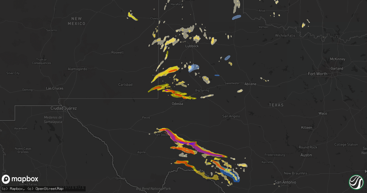
Hail Map on June 2, 2023
Get this storm
June 2 map
$229
one time, instant access
Download today. No call, no setup
Keep the $229
Bought the map and want the full workflow? Apply the entire $229 to a subscription within 7 days. None of it is wasted.
Every map, not just this one
This buys you this map. Subscription and you get every map we run, in the markets you choose from a few cities to whole states to nationwide. Plus real-time alerts the moment a storm fires.
Contact data
Name, contact info, occupancy, even credit band for addresses in the footprint. You go from where it hit to who to call.
Become the source they trust
Unlimited branding weather history reports on demand. You already have the documented answer ready for the property owner, and you are the one who showed up with it.
Property data and RoofTrace estimates
Pull up any address you have got, its value and the exact code rules for that jurisdiction, straight from One Click Code. Then RoofTrace estimates the squares, pitch, and roof value, priced the way you price.
States Impacted by Hail Map on June 2, 2023
Storm reports
New York
| Date | Description |
|---|---|
| 06/02/20235:15 PM CDT | Trees down on ny rte 133 with 2 lanes blocked. |
| 06/02/20235:15 PM CDT | One inch hail in diameter reported via social media near thunder ridge in patterson. Time estimated by radar. |
| 06/02/20235:10 PM CDT | Large tree and wires down on old route 55. |
| 06/02/20235:08 PM CDT | Hail size estimated from images posted on social media. |
| 06/02/20235:08 PM CDT | One large tree down on beacon rd. |
| 06/02/20234:45 PM CDT | Tree and wires down along county highway 12. Via county dispatch feed. Radar-estimated time. |
| 06/02/20233:56 PM CDT | Single tree down blocking mower rd near bush rd. Time estimated from radar |
| 06/02/20233:42 PM CDT | Multiple trees down in hurley. Time estimated from radar. |
| 06/02/20233:40 PM CDT | Tree limbs down on rte 209 in hurley. Time estimated from radar. |
| 06/02/20233:25 PM CDT | A local report indicates 1.50 inch wind near 1 SSE Herkimer |
| 06/02/20233:25 PM CDT | Trees and wires down on watkins road |
| 06/02/20233:24 PM CDT | Tree and wires down near the intersection of michigan st and walnut st. Time estimated from radar. |
| 06/02/20233:23 PM CDT | Time estimated from radar |
| 06/02/20233:20 PM CDT | Large tree down. |
| 06/02/20233:16 PM CDT | Time estimated from radar. |
| 06/02/20233:10 PM CDT | Tree down on road. Via county dispatch feed. Radar-estimated time. |
| 06/02/20232:55 PM CDT | Time estimated from radar |
| 06/02/20231:50 PM CDT | Two trees down. Time estimated. |
| 06/02/20231:40 PM CDT | 2 large trees downed. |
| 06/02/20231:36 PM CDT | Tree down blocking road. Via county dispatch feed. Radar-estimated time. |
| 06/02/20231:10 PM CDT | Two trees down on scribner ave and middlefort lane in middleburgh. |
| 06/02/202312:40 PM CDT | Downed trees and wires between veeder road and state hwy 334 in the town of mohawk. |
Pennsylvania
| Date | Description |
|---|---|
| 06/02/202312:00 PM CDT | Wires down on raymondskill road... Just south of silver springs road. Via dispatch scanner. Radar-estimated time. |
| 06/02/202311:53 AM CDT | Mutliple trees down on cliff park road. |
New Jersey
| Date | Description |
|---|---|
| 06/02/20236:16 PM CDT | A local report indicates 64 MPH wind near Trenton Mercer Airport |
Oklahoma
| Date | Description |
|---|---|
| 06/02/20234:45 PM CDT | A local report indicates 58 MPH wind near 1 SSW Beaver |
| 06/02/20234:05 PM CDT | A local report indicates 62 MPH wind near 12 NE Eva |
| 06/01/202311:15 PM CDT | 68 mph from the southeast. |
Vermont
| Date | Description |
|---|---|
| 06/02/20234:53 PM CDT | Tree down and power outage from thunderstorm downburst. |
North Dakota
| Date | Description |
|---|---|
| 06/02/20233:55 PM CDT | Awos station kd57 glen ullin. |
Alabama
| Date | Description |
|---|---|
| 06/02/20235:56 PM CDT | A tree knocked down along county road 703 in east cullman. Time estimated from radar. |
| 06/02/20234:38 PM CDT | Corrects previous tstm wnd dmg report from 1 ssw sheffield. A tree was blown down at 913 sw 12th avenue. |
| 06/02/20234:38 PM CDT | A tree was blown down at 1205 sw 13th avenue. |
| 06/02/20234:38 PM CDT | Corrects previous tstm wnd dmg report from 1 ssw sheffield. A tree was reported down at this location on pine street. |
| 06/02/20234:37 PM CDT | A tree was reported down near the intersection of s nashville avenue and e saywell street. |
| 06/02/20234:36 PM CDT | A tree was blown down near the intersection of e 5th street and annapolis avenue. |
| 06/02/20234:36 PM CDT | Corrects previous tstm wnd dmg report from 1 nne sheffield. A tree was reported down at 911 montgomery avenue. |
| 06/02/20234:36 PM CDT | A tree was reported down at 600 n montgomery avenue. |
| 06/02/20234:36 PM CDT | A tree was reported down at this location on pine street. |
| 06/02/20234:36 PM CDT | A power pole was reported damaged and leaning due to strong winds at this location. |
| 06/02/20234:35 PM CDT | Trees down and small hail in the sheffield area. |
| 06/02/20234:35 PM CDT | A tree was reported down near the intersection of ne 17th avenue and ne 28th street. |
| 06/02/20233:15 PM CDT | Tree down and power pole down near school house road and buddy williamson. |
| 06/02/20233:03 PM CDT | Corrects previous tstm wnd dmg report from 4 n new market. Tree down and power pole down near school house road and buddy williamson. |
Connecticut
| Date | Description |
|---|---|
| 06/02/20233:18 PM CDT | A local report indicates 1.00 inch wind near Portland |
| 06/02/20233:00 PM CDT | Quarter sized hail in east killingly relayed by media. |
| 06/02/20233:00 PM CDT | Quarter size hail in east killingly relayed by media. |
New Mexico
| Date | Description |
|---|---|
| 06/02/20231:15 PM CDT | A local report indicates 1.50 inch wind near Hobbs |
| 06/02/20231:15 PM CDT | Quarter size hail observed in downtown hobbs. |
| 06/02/202312:30 PM CDT | Damage: shredded leaves. |
Montana
| Date | Description |
|---|---|
| 06/02/20236:44 PM CDT | Mesonet station kigm8 king coulee. |
Massachusetts
| Date | Description |
|---|---|
| 06/02/20231:31 PM CDT | Tree down blocking rte 148 at colette road. |
Minnesota
| Date | Description |
|---|---|
| 06/02/20233:30 PM CDT | Social media picture of tree blown over in byron. |
Texas
| Date | Description |
|---|---|
| 06/02/20236:55 PM CDT | Asos station ksnk snyder winston. |
| 06/02/20236:50 PM CDT | Photo showing approximately 2 inch hail along us highway 90. |
| 06/02/20236:48 PM CDT | Report from mping: half dollar |
| 06/02/20236:48 PM CDT | Quarter size hail reported in greenwood. |
| 06/02/20236:47 PM CDT | Baseball size hail was reported. |
| 06/02/20236:45 PM CDT | Report from mping: half dollar |
| 06/02/20236:40 PM CDT | West texas mesonet |
| 06/02/20236:40 PM CDT | West texas mesonet. |
| 06/02/20236:38 PM CDT | Report from mping: half dollar |
| 06/02/20236:37 PM CDT | Multiple hail reports of ping pong to golf ball size hail. |
| 06/02/20236:35 PM CDT | Report from mping: quarter |
| 06/02/20236:33 PM CDT | Report from mping: half dollar |
| 06/02/20236:30 PM CDT | Measured quarter size hail in central midland. |
| 06/02/20236:29 PM CDT | Report from mping: quarter |
| 06/02/20236:27 PM CDT | Lots of nickel to quarter size hail. |
| 06/02/20236:25 PM CDT | Ping pong ball size hail reported near north wal-mart in midland. Time estimated by radar. |
| 06/02/20236:21 PM CDT | Report from mping: half dollar |
| 06/02/20236:09 PM CDT | West texas mesonet |
| 06/02/20236:09 PM CDT | West texas mesonet. |
| 06/02/20236:02 PM CDT | A local report indicates 1.25 inch wind near Gardendale |
| 06/02/20235:55 PM CDT | A local report indicates 60 MPH wind near 2 W Childress |
| 06/02/20235:54 PM CDT | Report from mping: quarter |
| 06/02/20235:50 PM CDT | Report from mping: half dollar |
| 06/02/20235:17 PM CDT | Hail observed on us385. |
| 06/02/20235:14 PM CDT | A local report indicates 3.00 inch wind near 1 SW Sheffield |
| 06/02/20235:13 PM CDT | Quarter size hail was reported at fort lancaster state historical site. |
| 06/02/20235:05 PM CDT | West texas mesonet |
| 06/02/20235:05 PM CDT | West texas mesonet. |
| 06/02/20234:58 PM CDT | Hail observed along us285. |
| 06/02/20234:43 PM CDT | Peak wind gust measured by the west texas mesonet. Also gusted to 81 mph at 4:44 pm... With several other severe caliber gusts from 4:36 pm to 4:46 pm. |
| 06/02/20234:41 PM CDT | A local report indicates 3.00 inch wind near 11 SW Sheffield |
| 06/02/20234:39 PM CDT | Hail observed along ranch rd 181. |
| 06/02/20234:39 PM CDT | 61 mph thunderstorm wind gust measured by mesonet at 4:39 p.m. Cdt. |
| 06/02/20234:38 PM CDT | Measured by the west texas mesonet. Gusts to 58 mph and 60 mph were measured at 4:36 pm and 4:37 pm... Respectively. |
| 06/02/20233:55 PM CDT | Awos station ke11 andrews. |
| 06/02/20233:53 PM CDT | Along harral rd. Just west of s st. Hwy 2886. |
| 06/02/20233:39 PM CDT | Measured by the west texas mesonet. It also gusted to 58 mph at 3:38 pm and 59 mph at 3:40 pm. |
| 06/02/20233:17 PM CDT | This west texas mesonet site also measured a gust to 59 mph at 3:20 pm. |
| 06/02/20233:17 PM CDT | This west tex |
| 06/02/20232:55 PM CDT | Em reports golf ball size hail on fm 2023 south of i-10. |
| 06/02/20232:50 PM CDT | Mesonet station 25 seminole 2n. |
| 06/02/20232:42 PM CDT | Em reports tennis ball sized hail 10 miles south of i-10 on fm 2023. |
| 06/02/20232:32 PM CDT | Em also reports broken power poles. 5 miles south of i-10 on fm 2023. |
| 06/02/20232:32 PM CDT | Em also reports broken power poles. |
| 06/02/20231:57 PM CDT | A local report indicates 59 MPH wind near 3 SW Dalhart |
| 06/02/20231:52 PM CDT | Corrects previous tornado report from 11 wsw paynes corner. Intermittently rain wrapped cone-shaped tornado observed south of us62 west of seminole. |
| 06/02/20231:52 PM CDT | Tornado observed crossing i-10 just before the junction with us385. Time estimated from radar/chaser report. |
| 06/02/20231:35 PM CDT | Chaser reported brief tornado at 1:35pm. |
| 06/02/20231:34 PM CDT | Tornado observed/photographed 6ne fort stockton. Time estimated from radar. |
| 06/02/20231:24 PM CDT | Golf ball sized hail observed along sh18 north of ft stockton. |
| 06/02/20231:20 PM CDT | Power poles down along sh18. Time estimated from radar. |
| 06/02/20231:18 PM CDT | Spotter observed apparent multivortex tornado east of nadine. |
| 06/02/202312:54 PM CDT | A local report indicates 63 MPH wind near 6 WSW Adrian |
| 06/02/202312:54 PM CDT | A local report indicates 63 MPH wind near 6 WSW Adrian |
| 06/02/202312:52 PM CDT | Intermittently rain wrapped cone-shaped tornado observed south of us62 west of seminole. |
| 06/02/202312:12 AM CDT | 50 knot wind gust at stinson asos. |
| 06/01/202311:42 PM CDT | Report from mping: 1-inch tree l |
| 06/01/202311:42 PM CDT | Report from mping: 1-inch tree limbs broken; shingles blown off. |
| 06/01/202311:35 PM CDT | Hondo asos 51 knot gust. |
| 06/01/202311:23 PM CDT | Report from mping: 1-inch tree limbs broken; shingles blown off. |
| 06/01/202311:20 PM CDT | At 11:20 pm... A 62 mph wind gust was reported at the weather station of southeast uvalde |
| 06/01/202310:18 PM CDT | A 1.5 inch hail report from brackettville |
| 06/01/20238:59 PM CDT | Mesonet station 97 throckmorton 1sw. |
| 06/01/20238:54 PM CDT | At 08:54 pm... Dime and quarter size hail was reported at seminole canyon state park. |
| 06/01/20237:11 PM CDT | Wind driven hail... Winds estimated at 60 mph. |
| 06/01/20237:06 PM CDT | Chaser shared photo of ongoing tornado south of highway 90. |
| 06/01/20237:04 PM CDT | Report from mping: hen egg+ |
New Hampshire
| Date | Description |
|---|---|
| 06/02/20236:15 PM CDT | Delayed report...large branches and a few trees down south of swanzey near the cemetery. Time estimated. |
| 06/02/20235:45 PM CDT | Delayed report...1-inch hail observed at cohoos pond. Time estimated. |
| 06/02/20235:40 PM CDT | Delayed report...broadcast media and multiple social media observed hail of quarter-size falling for 10 minutes. |
| 06/02/20235:30 PM CDT | Delayed report. Trees and branches down blocking traffic on railroad ave. Time estimated via radar. |
| 06/02/20235:30 PM CDT | A local report indicates 1.00 inch wind near 3 ESE Washington |
| 06/02/20235:30 PM CDT | Delayed report...quarter size hail observed. Time estimated by radar. |
| 06/02/20235:25 PM CDT | Trees down near route 31. |
| 06/02/20235:20 PM CDT | Delayed report...trees down on gleason falls rd north of hillsboro. Tree diameter up to 8 inches. Time estimated by radar. |
| 06/02/20235:09 PM CDT | Time estimated from radar. |
| 06/02/20233:50 PM CDT | Delayed report...multiple trees down at the farmington country club. Time estimated by radar. |
| 06/02/20233:30 PM CDT | Corrects previous tstm wnd dmg report from 3 ene middleton. Delayed report. Trees and branches down blocking traffic on railroad ave. Time estimated via radar. |
Nebraska
| Date | Description |
|---|---|
| 06/02/20235:01 PM CDT | Delayed report from earlier this evening. Unofficial personal weather station. |
| 06/02/20234:10 PM CDT | Emergency management confirmed landspout tornado...location only approximate as no discernible radar signature. |
| 06/02/20234:06 PM CDT | Report from mping: quarter |
| 06/02/20233:54 PM CDT | Roof peeled off chicken outbuilding. |
| 06/02/20233:52 PM CDT | A local report indicates 1.00 inch wind near 0.5 E Minatare |
| 06/01/20238:23 PM CDT | Trained spotter reported a weak tornado on the ground near the wildcat hills. It lasted for 2 to 3 minutes and dissipated. |
Maine
| Date | Description |
|---|---|
| 06/02/20233:06 PM CDT | Social media video of large tree down blocking main street. |
| 06/02/20233:01 PM CDT | Tree reported down on wires on river rd. Time estimated from radar. |
| 06/02/20232:06 PM CDT | Trees and power lines down across lake drive. |
| 06/02/20231:48 PM CDT | Tree down on power lines. Time estimated via radar. |
| 06/02/20231:47 PM CDT | Numerous trees down on wires and trees blocking roads. |
| 06/02/20231:47 PM CDT | Tree blocking road. |
| 06/02/20231:30 PM CDT | Trees down on wires. |
| 06/02/202312:54 PM CDT | Multiple trees down. |
Missouri
| Date | Description |
|---|---|
| 06/02/20234:59 PM CDT | Strong winds knocked down tree branches that downed powerlines. |
| 06/02/20234:05 PM CDT | Reported at kirksville regional airport. |
| 06/01/20238:39 PM CDT | Multiple trees down across roads. |
Florida
| Date | Description |
|---|---|
| 06/02/20232:10 PM CDT | A thunderstorm produced a wind gust of 61 mph at mesonet station 1343w |
Iowa
| Date | Description |
|---|---|
| 06/02/20233:20 PM CDT | 6 inch diameter tree limb down. Image submitted via social media. |
| 06/02/20233:03 PM CDT | Delayed report. |
| 06/02/20232:59 PM CDT | A local report indicates 59 MPH wind near Burlington Regional Air |
| 06/02/20231:58 PM CDT | Delayed report. Large... Healthy tree snapped at trunk near ferguson. Estimated size was 2 and a half feet in diameter. Report submitted via social media. |
Cities Impacted by Hail Map on June 2, 2023
- Hobbs, NM
- Osborne, KS
- Cimarron, NM
- Alva, OK
- Waynoka, OK
- Rogers, NM
- Fort Stockton, TX
- Portis, KS
- Muleshoe, TX
- Morton, TX
- Pep, NM
- Causey, NM
- Milnesand, NM
- Farwell, TX
- Portales, NM
- Imperial, TX
- Seminole, TX
- Jal, NM
- Eunice, NM
- Merrill, WI
- Seagraves, TX
- Monahans, TX
- Coyanosa, TX
- Andrews, TX
- Kermit, TX
- Plains, TX
- Chichester, NY
- Loop, TX
- Willow, NY
- Woodstock, NY
- Glenford, NY
- West Hurley, NY
- Brownfield, TX
- Putnam, CT
- Chepachet, RI
- Dayville, CT
- Foster, RI
- East Killingly, CT
- Danielson, CT
- Sheffield, TX
- Middletown, CT
- Portland, CT
- Cromwell, CT
- Ilion, NY
- Mohawk, NY
- Herkimer, NY
- Dryden, TX
- Bayard, NE
- Gering, NE
- Minatare, NE
- Odonnell, TX
- Lamesa, TX
- Gail, TX
- Tahoka, TX
- Pawling, NY
- Holmes, NY
- Patterson, NY
- Briarcliff Manor, NY
- Tarrytown, NY
- Pleasantville, NY
- Ozona, TX
- Taiban, NM
- Stanton, TX
- Gardendale, TX
- Midland, TX
- Childress, TX
- Floyd, NM
- Norfolk, NY
- Chase Mills, NY
- Massena, NY
- Maxbass, ND
- Bryant Pond, ME
- Rumford, ME
- Saint Johnsville, NY
- Fort Plain, NY
- Little Falls, NY
- Turpin, OK
- Anson, ME
- Hillsborough, NH
- Harmony, ME
- Fairview, OK
- Skowhegan, ME
- Madison, ME
- Amsterdam, NY
- Littlefield, TX
- Etna, ME
- Carmel, ME
- Hampden, ME
- Wausau, WI
- Fairfield, ME
- Waterville, ME
- Tomahawk, WI
- Rhinelander, WI
- Storrs Mansfield, CT
- Andover, CT
- Coventry, CT
- Willington, CT
- Fort Yates, ND
- Gleason, WI
- Wiley, CO
- Peerless, MT
- Iron River, MI
- Trout Creek, MI
- Laverne, OK
- Canadian, TX
- West Forks, ME
- Norridgewock, ME
- Solon, ME
- Pittsfield, NH
- Halstad, MN
- Central City, NE
- Archer, NE
- Tolna, ND
- Pekin, ND
- Barron, WI
- Glendive, MT
- Mcville, ND
- Cobalt, CT
- Glastonbury, CT
- South Glastonbury, CT
- Middle Haddam, CT
- Mexico, ME
- Petersburg, TX
- Idalou, TX
- Amherst, TX
- Swanzey, NH
- Savage, MT
- Richey, MT
- Randolph, IA
- Tabor, IA
- Malvern, IA
- Grant, NE
- Madrid, NE
- Greenwood, ME
- North Anson, ME
- Clarendon, TX
- Brooklyn, CT
- Pomfret Center, CT
- Bingham, ME
- Wellington, TX
- Southfield, MA
- Vassalboro, ME
- Jordanville, NY
- Welch, TX
- Cohagen, MT
- Hiram, ME
- Bloomfield, MT
- Campbell, MO
- Hartwick, NY
- Burlington Flats, NY
- Spearman, TX
- Hardesty, OK
- Fallon, MT
- Shapleigh, ME
- West Newfield, ME
- Acton, ME
- Campton, NH
- Kinsey, MT
- Northville, NY
- Hadley, NY
- Belle, MO
- Bland, MO
- Chester, OK
- Newport, NY
- Floydada, TX
- Lockney, TX
- Shamrock, TX
- Hereford, TX
- Sundance, WY
- Devils Tower, WY
- Ismay, MT
- Norfolk, CT
- Colebrook, CT
- Winsted, CT
- Madison, KS
- Olpe, KS
- Hartford, KS
- Lanesville, NY
- Arapaho, OK
- Clinton, OK
- Adrian, TX
- Beulah, WY
- Aladdin, WY
- Chelmsford, MA
- Westford, MA
- North Chelmsford, MA
- Weskan, KS
- Frankfort, NY
- Grinnell, IA
- Cherry Valley, NY
- Olton, TX
- Abernathy, TX
- Hale Center, TX
- Fieldton, TX
- Plainview, TX
- Bennington, NH
- Hancock, NH
- Tarzan, TX
- Bellingham, MA
- Medway, MA
- Franklin, MA
- Tobias, NE
- Clay Center, KS
- Cheyenne, OK
- Mondovi, WI
- Eau Claire, WI
- Wheeler, TX
- Canute, OK
- Dill City, OK
- Foss, OK
- Holts Summit, MO
- Sheffield, IA
- Great Barrington, MA
- Emporia, KS
- Holderness, NH
- Plymouth, NH
- Mansfield Center, CT
- Chaplin, CT
- Marmaduke, AR
- Paragould, AR
- West Brookfield, MA
- Brookfield, MA
- North Brookfield, MA
- Gatewood, MO
- Doniphan, MO
- Whiteface, TX
- Burlington, KS
- Murray, NE
- Nehawka, NE
- Arnett, OK
- Shattuck, OK
- Athens, ME
- Milan, NH
- Hasty, CO
- McClave, CO
- Las Animas, CO
- Green, KS
- East Hampton, CT
- Hillsboro, ND
- Ribera, NM
- Norway, ME
- Brimfield, MA
- Brockway, MT
- Terry, MT
- Carter, OK
- Wymore, NE
- Marysville, KS
- Odell, NE
- Follett, TX
- Levelland, TX
- Pep, TX
- Eads, CO
- Lamar, CO
- Phoenicia, NY
- Shandaken, NY
- West Winfield, NY
- Richfield Springs, NY
- Gruver, TX
- Epsom, NH
- Chichester, NH
- Hillsdale, NY
- Sterling, CT
- Lovington, NM
- Denver City, TX
- Humboldt, NE
- Auburn, NE
- Crosbyton, TX
- North Adams, MA
- Stamford, VT
- Mooreland, OK
- Aline, OK
- Dacoma, OK
- Fort Lauderdale, FL
- Middleville, NY
- Woodward, OK
- Oxford, MA
- North Oxford, MA
- Auburn, NH
- Elk Mound, WI
- Tatum, NM
- Cornish, ME
- Sunray, TX
- Plains, KS
- Brewster, NY
- South Salem, NY
- Ridgefield, CT
- Fargo, OK
- Dolgeville, NY
- Sheridan Lake, CO
- South Egremont, MA
- Arapahoe, CO
- Lubbock, TX
- Shallowater, TX
- New Deal, TX
- Briscoe, TX
- Anthony, KS
- Worcester, NY
- Lafe, AR
- Burr Oak, KS
- Russellville, AL
- Bridgton, ME
- Wibaux, MT
- Booker, TX
- Beatrice, NE
- Sweetwater, OK
- Haleyville, AL
- Shokan, NY
- Bunceton, MO
- Anton, TX
- Charlton, MA
- Jamestown, MO
- Buffalo, OK
- Fort Supply, OK
- Clayville, NY
- Parsonsfield, ME
- Lorenzo, TX
- La Plata, MO
- Belleview, MO
- Ellington, CT
- Thompson, CT
- Dumas, TX
- Hooker, OK
- Kirksville, MO
- Mobeetie, TX
- Richfield, KS
- California, MO
- Immokalee, FL
- Haigler, NE
- Copake Falls, NY
- Copake, NY
- Talmage, NE
- Kingfisher, OK
- Grahamsville, NY
- Sudan, TX
- Enochs, TX
- Friona, TX
- Napanoch, NY
- Ellenville, NY
- Gilboa, NY
- Grand Gorge, NY
- Holland, MA
- Ashland, MA
- Framingham, MA
- Holliston, MA
- Sherborn, MA
- Mount Tremper, NY
- Poland, NY
- Utica, NY
- Leedey, OK
- Hugoton, KS
- Comstock, TX
- Garden City, TX
- Jayton, TX
- Aspermont, TX
- Snyder, TX
- Del Rio, TX
- Sonora, TX
- Rocksprings, TX
- Brackettville, TX
- Barksdale, TX
- Bradford, NH
- Thomas, OK
- Fairfax, MO
- Kennedyville, MD
- Millington, MD
- Wheatland, ND
- Stoddard, NH
- Nelson, NH
- Hinsdale, MT
- Garden City, KS
- Larslan, MT
- Frederick, OK
- Omega, OK
- Carmel, NY
- Leoti, KS
- Blackwell, TX
- Tuscola, TX
- Fort Peck, MT
- Rugby, ND
- Otterville, MO
- Shubert, NE
- Nemaha, NE
- Rock Port, MO
- Kingfield, ME
- Hobart, OK
- New Raymer, CO
- Scobey, MT
- Tucumcari, NM
- Springfield Center, NY
- Watersmeet, MI
- Platte City, MO
- Weston, MO
- Dearborn, MO
- Irvington, NY
- Falls City, NE
- Mountain View, OK
- Roosevelt, OK
- Mound City, MO
- Maitland, MO
- Tipton, OK
- Butler, OK
- Croton Falls, NY
- Purdys, NY
- North Salem, NY
- Somers, NY
- Perryton, TX
- Miami, TX
- Upton, WY
- Meade, KS
- Wallace, KS
- Winona, KS
- Chestertown, MD
- Johnson, KS
- Hurley, NY
- Trenton, NJ
- Morrisville, PA
- Washington Crossing, PA
- Pennington, NJ
- Titusville, NJ
- Ossining, NY
- Millwood, NY
- Sterling City, TX
- Ackerly, TX
- Coahoma, TX
- Big Spring, TX
- Hartville, WY
- Rocky, OK
- Sentinel, OK
- Centreville, MD
- Dodson, TX
- Worton, MD
- West Burlington, NY
- Mount Vision, NY
- House, NM
- Harrisville, NH
- Graham, MO
- Lenox, IA
- Westbrook, TX
- Readsboro, VT
- Earleville, MD
- Dickens, TX
- Sidney, IA
- Rulo, NE
- White Cloud, KS
- Hiawatha, KS
- Chattanooga, OK
- Loveland, OK
- Summit, NJ
- New Providence, NJ
- Mountainside, NJ
- Berkeley Heights, NJ
- Scotch Plains, NJ
- Sharon Springs, KS
- Granite, OK
- Fort Sumner, NM
- Sherburne, NY
- Rotan, TX
- Indiahoma, OK
- Newtown, PA
- Nelson, WI
- Gotebo, OK
- Danby, VT
- Rushford, MN
- Peterson, MN
- Mangum, OK
- Mcadoo, TX
- Durand, WI
- Hubbardsville, NY
- Pierceville, KS
- Sublette, KS
- Scott City, KS
- Roby, TX
- Philadelphia, PA
- Willow, OK
- Poughquag, NY
- Paducah, TX
- Cordell, OK
- Wallingford, VT
- Pampa, TX
- Ellijay, GA
- Langhorne, PA
- Feasterville Trevose, PA
- Castroville, TX
- Camp Wood, TX
- Wingate, TX
- Leakey, TX
- Clyde, TX
- Moran, TX
- Waurika, OK
- Ryan, OK
- Gainesville, TX
- Marietta, OK
- Morrill, NE
- Lyman, NE
- Howe, TX
- Collinsville, TX
- Baird, TX
- Texico, NM
- Camden Point, MO
- Ringling, OK
- Atascosa, TX
- Vega, TX
- Craig, MO
- Merkel, TX
- Loco, OK
- Albany, TX
- Vandalia, MT
- Redding, CT