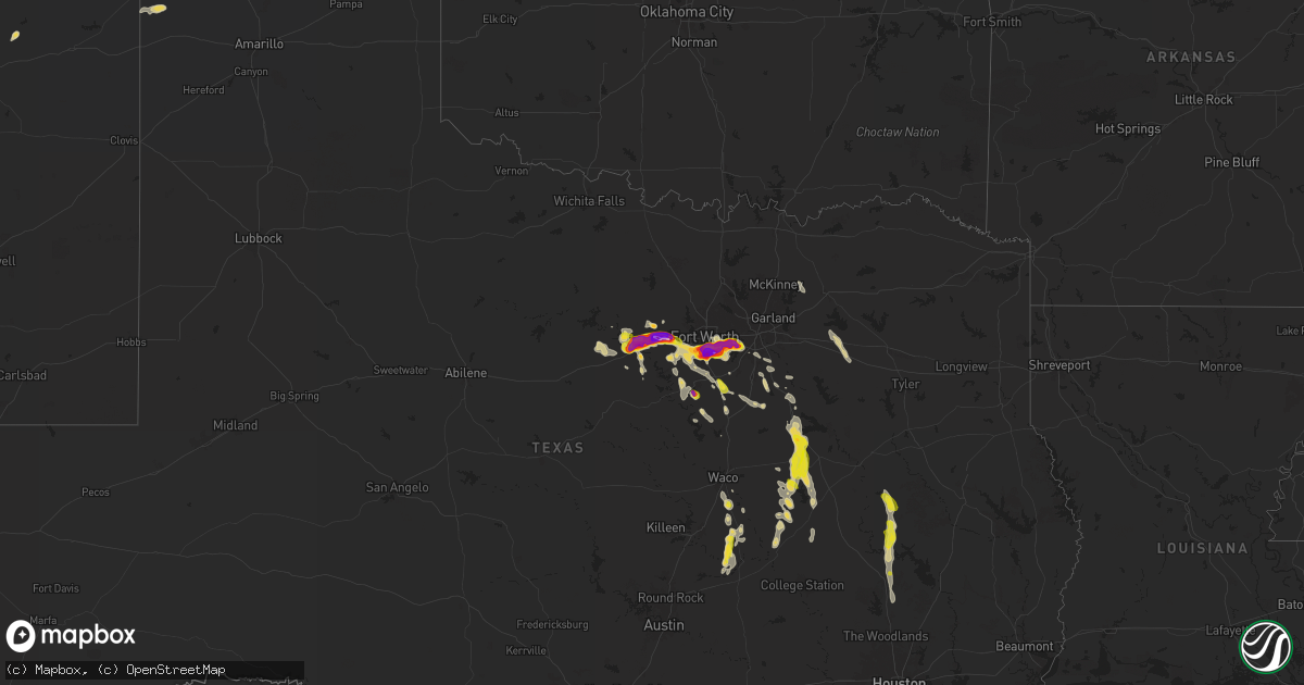
Hail Map on June 1, 2025
Get this storm
June 1 map
$229
one time, instant access
Download today. No call, no setup
Keep the $229
Bought the map and want the full workflow? Apply the entire $229 to a subscription within 7 days. None of it is wasted.
Every map, not just this one
This buys you this map. Subscription and you get every map we run, in the markets you choose from a few cities to whole states to nationwide. Plus real-time alerts the moment a storm fires.
Contact data
Name, contact info, occupancy, even credit band for addresses in the footprint. You go from where it hit to who to call.
Become the source they trust
Unlimited branding weather history reports on demand. You already have the documented answer ready for the property owner, and you are the one who showed up with it.
Property data and RoofTrace estimates
Pull up any address you have got, its value and the exact code rules for that jurisdiction, straight from One Click Code. Then RoofTrace estimates the squares, pitch, and roof value, priced the way you price.
States Impacted by Hail Map on June 1, 2025
Storm reports
Colorado
| Date | Description |
|---|---|
| 06/01/20255:58 PM CDT | A local report indicates 1.00 inch wind near 1 N Pueblo West |
Wyoming
| Date | Description |
|---|---|
| 06/01/20255:40 PM CDT | Report from mping: quarter |
| 06/01/20255:31 PM CDT | A local report indicates 1.00 inch wind near 0.5 WSW Cheyenne |
| 06/01/20255:30 PM CDT | At the nws cheyenne office... There was accumulating pea to dime sized hail with quarters and half dollars being the largest stones found taking hail measurements. |
| 05/31/20258:35 PM CDT | A local report indicates 1.25 inch wind near Wright |
| 05/31/20257:15 PM CDT | A local report indicates 1.00 inch wind near Mammoth |
South Carolina
| Date | Description |
|---|---|
| 06/01/20255:00 PM CDT | Utility company reports power outage due to fallen trees. |
Texas
| Date | Description |
|---|---|
| 06/01/20256:58 PM CDT | Report from mping: hen egg+ |
| 06/01/20256:58 PM CDT | Report from mping: quarter |
| 06/01/20256:57 PM CDT | Report from mping: quarter |
| 06/01/20256:56 PM CDT | Facebook photo showed apple size hail fell in far south fort worth. |
| 06/01/20256:56 PM CDT | Report from mping: ping pong ball |
| 06/01/20256:55 PM CDT | A local report indicates 2.00 inch wind near 2 W Edgecliff |
| 06/01/20256:55 PM CDT | Report from mping: half dollar |
| 06/01/20256:55 PM CDT | Report from mping: half dollar |
| 06/01/20256:55 PM CDT | Report from mping: ping pong ball |
| 06/01/20256:54 PM CDT | Report from mping: half dollar |
| 06/01/20256:54 PM CDT | Report from mping: half dollar |
| 06/01/20256:54 PM CDT | Report from mping: half dollar |
| 06/01/20256:37 PM CDT | Facebook report of several broken power poles and downed power lines just east of buckholts. |
| 06/01/20256:35 PM CDT | Stormchaser video showed estimated 60 mph winds and large hail. |
| 06/01/20256:25 PM CDT | Corrects previous tstm wnd gst report from buckholts. Stormchaser video in marak showed estimated 60-70 mph winds and large hail. |
| 06/01/20255:34 PM CDT | Tree limbs and power lines down. |
| 06/01/20255:20 PM CDT | Facebook report of quarter size hail on fm 916 near the ellis county line. |
| 06/01/20255:11 PM CDT | Facebook photo showed penny to quarter size hail fell on cr 204. |
| 06/01/20255:05 PM CDT | Facebook photo showed quarter size hail fell in the nolan river estates area. |
| 06/01/20255:03 PM CDT | Report from mping: quarter |
| 06/01/20254:58 PM CDT | Facebook photo showed up to quarter size hail fell near lake pat cleburne. |
| 06/01/20254:25 PM CDT | Report of a few trees down across roadways northeast of conroe due to thunderstorm winds. |
| 06/01/20253:10 PM CDT | County dispatch reported of tree on road... And trees into power lines due to thunderstorm winds. |
| 06/01/20252:28 PM CDT | Half dollar reported in box church. |
| 06/01/20251:36 PM CDT | Photo of tree damage in mexia. |
| 06/01/202510:21 AM CDT | Corrects previous tstm wnd dmg report from canton. Video on x showed several trees blown down in canton. News reports indicate several homes and businesses suffered roo |
| 06/01/202510:21 AM CDT | Video on x showed several trees blown down in canton. |
| 06/01/20259:55 AM CDT | Several trees down and large carport of home collapsed in wills point. |
| 05/31/202510:05 PM CDT | Numerous power outages due to downed lines around lake limestone. |
| 05/31/202510:05 PM CDT | A local report indicates 0 MPH wind near 8 NNW Marquez |
| 05/31/20259:33 PM CDT | Power line down across fm 1512 with power outages in area. |
| 05/31/20258:48 PM CDT | Report from mping: ping pong ball |
| 05/31/20258:47 PM CDT | Half dollar sized hail 1 south of parker county airport. |
| 05/31/20258:47 PM CDT | Report from mping: ping pong ball |
| 05/31/20258:46 PM CDT | Report from mping: half dollar |
| 05/31/20258:46 PM CDT | Report from mping: quarter |
| 05/31/20258:45 PM CDT | Report from mping: quarter |
| 05/31/20258:43 PM CDT | Report from mping: quarter |
| 05/31/20258:43 PM CDT | Report from mping: half dollar |
| 05/31/20258:42 PM CDT | Hen egg sized hail near the i-20 / highway 180 split. |
| 05/31/20258:40 PM CDT | A local report indicates 1.75 inch wind near Hudson Oaks |
| 05/31/20258:35 PM CDT | Report from mping: half dollar |
| 05/31/20258:34 PM CDT | Report from mping: tennis ball |
| 05/31/20258:33 PM CDT | A local report indicates 3.00 inch wind near 3 NNW Hudson Oaks |
| 05/31/20258:31 PM CDT | Report from mping: ping pong ball |
| 05/31/20258:30 PM CDT | A local report indicates 1.50 inch wind near 1 NNW Weatherford |
| 05/31/20258:27 PM CDT | Report from mping: quarter |
| 05/31/20258:27 PM CDT | Quarter to golf ball sized hail covering the ground in weatherford. |
| 05/31/20258:26 PM CDT | Report from mping: ping pong ball |
| 05/31/20258:20 PM CDT | A local report indicates 3.00 inch wind near 5 W Weatherford |
| 05/31/20258:19 PM CDT | 2-inch diamet |
| 05/31/20258:19 PM CDT | 2-inch diameter hail 1 mile west of weatherford high school. |
| 05/31/20258:15 PM CDT | A local report indicates 3.00 inch wind near 1 SW Weatherford |
| 05/31/20258:12 PM CDT | A local report indicates 1.75 inch wind near 1 W Weatherford |
| 05/31/20258:12 PM CDT | A local report indicates 1.75 inch wind near 2 SW Weatherford |
| 05/31/20258:06 PM CDT | Hen egg sized hail near mile marker 401 on i-20. |
| 05/31/20258:03 PM CDT | Report from mping: quarter |
| 05/31/20258:01 PM CDT | Report from mping: quarter |
| 05/31/20258:00 PM CDT | Report from mping: quarter |
| 05/31/20257:58 PM CDT | Report from mping: ping pong ball |
| 05/31/20257:54 PM CDT | Report from mping: hen egg |
| 05/31/20257:51 PM CDT | Report from mping: half dollar |
| 05/31/20257:49 PM CDT | Report from mping: hen egg |
| 05/31/20257:48 PM CDT | Report from mping: tennis ball |
| 05/31/20257:47 PM CDT | Report from mping: hen egg+ |
| 05/31/20257:43 PM CDT | Report from mping: half dollar |
| 05/31/20257:42 PM CDT | Delayed report. Report from mping: quarter |
| 05/31/20257:42 PM CDT | Report from mping: quarter |
| 05/31/20257:41 PM CDT | Report from mping: half dollar |
| 05/31/20257:41 PM CDT | Report from mping: hen egg |
| 05/31/20257:40 PM CDT | Report from mping: half dollar |
| 05/31/20257:40 PM CDT | Ping pong ball sized hail near collins and mayfield. |
| 05/31/20257:38 PM CDT | Report from mping: hen egg |
| 05/31/20257:37 PM CDT | Delayed report. Report from mping: quarter |
| 05/31/20257:33 PM CDT | A local report indicates 2.50 inch wind near 1 W Dalworthington Gar |
| 05/31/20257:33 PM CDT | Report from mping: ping pong ball |
| 05/31/20257:32 PM CDT | Report from mping: half dollar |
| 05/31/20257:25 PM CDT | A local report indicates 1.75 inch wind near 2 NNE Kennedale |
| 05/31/20257:25 PM CDT | Report from mping: half dollar |
| 05/31/20257:24 PM CDT | Report from mping: quarter |
| 05/31/20257:23 PM CDT | Report from mping: ping pong ball |
| 05/31/20257:23 PM CDT | Tennis ball sized hail at polly webb and green oaks in arlington. |
| 05/31/20257:23 PM CDT | Report from mping: ping pong ball |
| 05/31/20257:21 PM CDT | Report from mping: ping pong ball |
| 05/31/20257:20 PM CDT | Report from mping: half dollar |
| 05/31/20257:19 PM CDT | Report from mping: golf ball |
| 05/31/20257:19 PM CDT | Report from mping: hen egg |
| 05/31/20257:19 PM CDT | Report from mping: golf ball |
| 05/31/20257:15 PM CDT | Delayed report. Report from mping: half dollar |
| 05/31/20257:04 PM CDT | Report from mping: quarter |
| 05/31/20257:03 PM CDT | A local report indicates 2.00 inch wind near Everman |
| 05/31/20257:00 PM CDT | Delayed report. Baseball sized hail reported in everman. |
| 05/31/20257:00 PM CDT | Report from mping: quarter |
Florida
| Date | Description |
|---|---|
| 06/01/20259:40 AM CDT | Broadcast media and social media reports multiple trees down in the margate area around 1040 am. Some fence damage reported as well. |
| 06/01/20259:36 AM CDT | Broadcast media reports uprooted tree in coral springs community as a severe thunderstorm moved across the area. Time is radar estimated. |
Utah
| Date | Description |
|---|---|
| 06/01/20256:45 PM CDT | Mesonet station vrh vernon hill. |
| 06/01/20254:30 PM CDT | Mesonet station utbev i-15 at beaver. |
| 05/31/20259:20 PM CDT | Mesonet station utstv us-40 at starvation. |
| 05/31/20257:30 PM CDT | Mesonet station ucc01 snowville |
North Carolina
| Date | Description |
|---|---|
| 06/01/20255:52 PM CDT | Trees down in roseboro. |
| 06/01/20254:25 PM CDT | Trees down on utility equipment. |
| 06/01/20254:13 PM CDT | Trees down on utility equipment. |
| 06/01/20252:45 PM CDT | Tree down on utility lines at pleasant grove church rd between flat creek rd and jimmy cox rd. |
| 06/01/20252:35 PM CDT | Trees down on power lines at north moore rd and north middleton st. |
| 05/31/20257:58 PM CDT | Report of quarter sized hail. |
| 05/31/20257:40 PM CDT | Reports of quarter sized hail as well as penny and marble size. |
| 05/31/20257:36 PM CDT | Report of quarter sized hail. |
Cities Impacted by Hail Map on June 1, 2025
- Marshall, OK
- Crescent, OK
- Guthrie, OK
- Mulhall, OK
- Edmond, OK
- Arcadia, OK
- Luther, OK
- Meridian, OK
- Choctaw, OK
- Jones, OK
- Harrah, OK
- Newalla, OK
- Farmersville, TX
- Wills Point, TX
- Canton, TX
- Corsicana, TX
- Richland, TX
- Streetman, TX
- Wortham, TX
- Mexia, TX
- Teague, TX
- Grapeland, TX
- Crockett, TX
- Groesbeck, TX
- Lovelady, TX
- Trinity, TX
- Thornton, TX
- Florissant, CO
- Divide, CO
- Huntsville, TX
- Franklin, TX
- Kosse, TX
- La Veta, CO
- Bremond, TX
- Cimarron, NM
- Walsenburg, CO
- Aguilar, CO
- Calvert, TX
- Willis, TX
- New Waverly, TX
- Raton, NM
- Conroe, TX
- Cleburne, TX
- Hereford, AZ
- Waco, TX
- Lorena, TX
- Hearne, TX
- Chilton, TX
- Lima, MT
- Alvarado, TX
- Virginia City, MT
- Cheyenne, WY
- Grandview, TX
- Rio Vista, TX
- Colorado Springs, CO
- Lott, TX
- George West, TX
- Cameron, MT
- Penrose, CO
- Rosebud, TX
- Ten Sleep, WY
- Fe Warren Afb, WY
- Pueblo, CO
- Lipan, TX
- Granbury, TX
- Conchas Dam, NM
- Blum, TX
- Godley, TX
- Commerce City, CO
- Orange Grove, TX
- Itasca, TX
- Burlington, TX
- Henderson, CO
- Pierce, CO
- Nunn, CO
- Gallatin Gateway, MT
- Wheatland, WY
- Garita, NM
- Grover, CO
- Brighton, CO
- Cresson, TX
- Weatherford, TX
- Carpenter, WY
- Hillsboro, TX
- Buckholts, TX
- Emigrant, MT
- Cheraw, SC
- Whitney, TX
- Fort Worth, TX
- Dubois, ID
- Spencer, ID
- Avondale, CO
- Carr, CO
- Boone, CO
- Livingston, MT
- Pray, MT
- Gordon, TX
- Rogers, TX
- Cameron, TX
- West Yellowstone, MT
- Orrum, NC
- Lumberton, NC
- Crowley, TX
- Joshua, TX
- Strawn, TX
- Aledo, TX
- Council, NC
- Clarkton, NC
- Elizabethtown, NC
- Nemo, TX
- Ferris, TX
- Palmer, TX
- Ennis, TX
- Mansfield, TX
- Burleson, TX
- Kennedale, TX
- Fairmont, NC
- Bladenboro, NC
- Evergreen, NC
- Waxahachie, TX
- Kelly, NC
- Venus, TX
- Rockdale, TX
- Davilla, TX
- Santo, TX
- Palo Pinto, TX
- Whiteville, NC
- Arlington, TX
- Chadbourn, NC
- Mineral Wells, TX
- Grand Prairie, TX
- Casper, WY
- Lake View, SC
- Fort Morgan, CO
- Abbott, TX
- Millsap, TX
- La Junta, CO
- Rice, TX
- Eustace, TX
- Sugar City, CO
- Gillette, WY
- Bluff Dale, TX
- Hiland, WY
- Chatfield, TX
- Dallas, TX
- Cedar Hill, TX
- Duncanville, TX
- Arminto, WY
- Wright, WY
- Desoto, TX
- Lancaster, TX
- Glenrock, WY
- Springtown, TX
- Donie, TX
- Seibert, CO
- Flagler, CO
- Jewett, TX
- Evansville, WY
- Marquez, TX
- Douglas, WY
- Vona, CO
- Tolar, TX
- Osage, WY
- Italy, TX
- Blooming Grove, TX
- Normangee, TX
- Chesterfield, SC
- Maypearl, TX