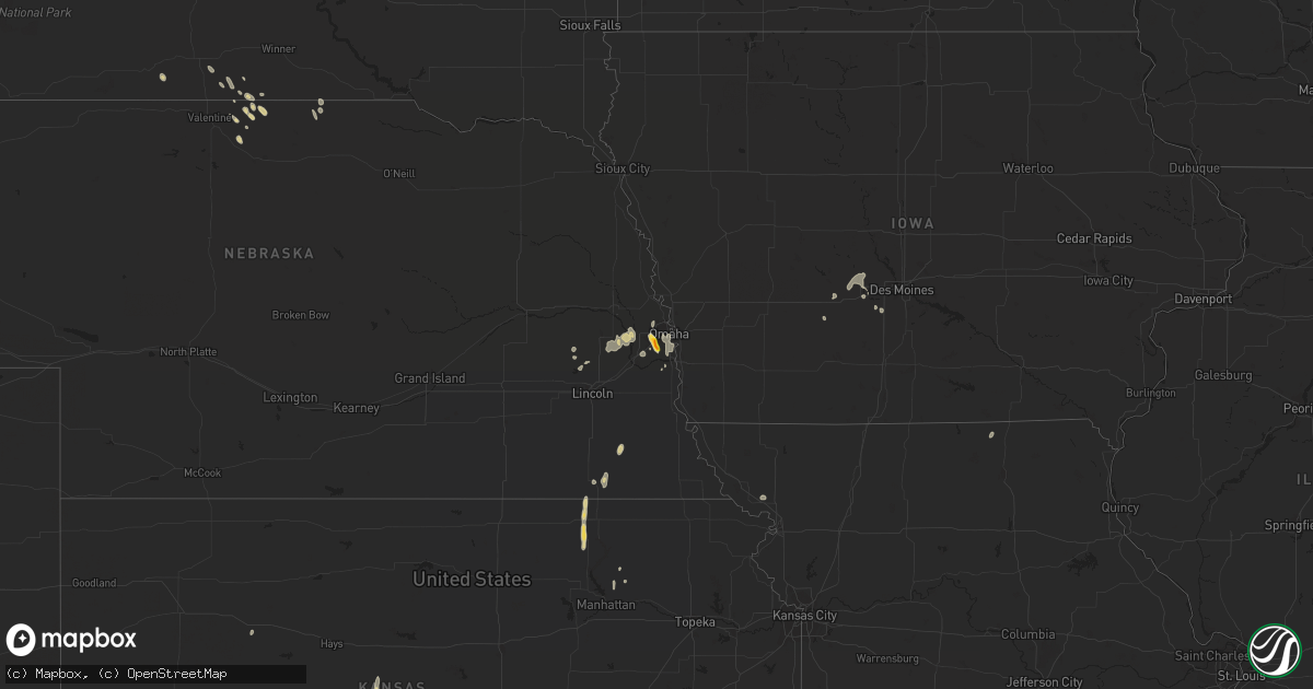
Hail Map on June 1, 2023
Get this storm
June 1 map
$229
one time, instant access
Download today. No call, no setup
Keep the $229
Bought the map and want the full workflow? Apply the entire $229 to a subscription within 7 days. None of it is wasted.
Every map, not just this one
This buys you this map. Subscription and you get every map we run, in the markets you choose from a few cities to whole states to nationwide. Plus real-time alerts the moment a storm fires.
Contact data
Name, contact info, occupancy, even credit band for addresses in the footprint. You go from where it hit to who to call.
Become the source they trust
Unlimited branding weather history reports on demand. You already have the documented answer ready for the property owner, and you are the one who showed up with it.
Property data and RoofTrace estimates
Pull up any address you have got, its value and the exact code rules for that jurisdiction, straight from One Click Code. Then RoofTrace estimates the squares, pitch, and roof value, priced the way you price.
States Impacted by Hail Map on June 1, 2023
Storm reports
New Mexico
| Date | Description |
|---|---|
| 06/01/20236:13 PM CDT | 2 inch hail falling now at this location. |
| 06/01/20236:00 PM CDT | 1.5 inch hail falling now. |
| 06/01/20235:35 PM CDT | Hail covering highway 54... Hail lasted 15 minutes. Biggest hailstone 1.75 inch... Mostly 1-1.5 inches. |
| 06/01/20235:30 PM CDT | Hail lasted 10 minutes. |
| 06/01/20235:16 PM CDT | Hail from 2nd storm... Following same path as first one. |
| 06/01/20234:30 PM CDT | Hail covering street highway 219. |
| 06/01/20233:43 PM CDT | Hail accumulations of up to 3 inches has fallen. |
| 05/31/20238:26 PM CDT | A local report indicates 2.00 inch wind near 7 W House |
Minnesota
| Date | Description |
|---|---|
| 06/01/20235:20 PM CDT | 61mph wind gusts measured at the ndawn site. |
Illinois
| Date | Description |
|---|---|
| 06/01/20232:50 PM CDT | Hail fell for almost ten minutes on the west side of joliet with the largest hailstones being roughly quarter size. Time estimated from radar. |
Idaho
| Date | Description |
|---|---|
| 06/01/20235:26 PM CDT | A local report indicates 1.00 inch wind near 3 N Cherry Creek |
South Dakota
| Date | Description |
|---|---|
| 06/01/20236:48 PM CDT | A local report indicates 60 MPH wind near 1 N BUFFALO |
| 06/01/20235:59 PM CDT | A local report indicates 62 MPH wind near 12 WSW CASTLE ROCK |
| 06/01/20233:15 PM CDT | Wind tipped a trailer on us hwy 281... 2 miles south of aberdeen. |
Montana
| Date | Description |
|---|---|
| 06/01/20233:59 PM CDT | Quarter size hail reported by spotter along with 0.62 of rain in 21 minutes. |
| 06/01/20233:54 PM CDT | Spotter reports various sizes of hail fell for nearly 20 minutes. Largest was ping pong size. Time of report is when largest hail size correlates to radar data. Estimat |
| 05/31/20237:47 PM CDT | A local report indicates 1.00 inch wind near 12 WSW Billings |
Oklahoma
| Date | Description |
|---|---|
| 06/01/20234:58 PM CDT | Delayed report. Picture of uprooted tree... Approximately 1-2 feet in diameter... Shared via social media. Time estimated via radar. |
| 06/01/20234:58 PM CDT | Small tree limbs broken. Time estimated by radar. |
| 06/01/20234:58 PM CDT | Delayed report. Picture of uprooted tree... Approximately 1-2 feet in diameter... Shared via social media. Time estimated via radar. |
Nebraska
| Date | Description |
|---|---|
| 06/01/20234:30 PM CDT | A local report indicates 60 MPH wind near 2 NW Ralston |
| 06/01/20234:30 PM CDT | A local report indicates 1.00 inch wind near 2 W La Vista |
| 06/01/20234:29 PM CDT | A local report indicates 1.50 inch wind near 2 W Ralston |
| 06/01/20234:24 PM CDT | Delayed report. Social media photo of large tree limbs down. Time estimated from radar. |
| 06/01/20234:24 PM CDT | Delayed report. Social media photo of large tree limbs down. Time estimated from radar. |
| 06/01/20234:24 PM CDT | 60 mph winds also. |
| 06/01/20234:20 PM CDT | A local report indicates 1.00 inch wind near 2 WNW La Vista |
North Dakota
| Date | Description |
|---|---|
| 06/01/20234:45 PM CDT | 52nd street between i-29 and university... 6-10 inch diameter trees snapped in half. |
Indiana
| Date | Description |
|---|---|
| 06/01/20233:58 PM CDT | Trained spotter reports downed branches up to 8 inches in diameter near merrillville road at 86th place in merrillville. Hail up to dime size also occurred. Time estima |
| 06/01/20233:45 PM CDT | A local report indicates 1.00 inch wind near Merrillville |
Colorado
| Date | Description |
|---|---|
| 06/01/20233:30 PM CDT | Photos and video of hail falling south of kiowa. Most stones were smaller than penny size... But the largest stones were roughly 1 inch in diameter. Time estimated by r |
Texas
| Date | Description |
|---|---|
| 06/01/20236:53 PM CDT | Time estimated from radar |
| 06/01/20236:53 PM CDT | Time estimated from radar |
| 06/01/20235:30 PM CDT | Minor damage to roof resulting in water leaking into house. A horse trailer was blown over and rolled approx 60 ft. |
| 06/01/20235:18 PM CDT | Wind-driven ping pong ball size hail stripped leaves off trees. |
| 06/01/20235:18 PM CDT | Fences blown over and a collapsed carport in downtown anson. |
| 06/01/20235:12 PM CDT | Report from mping: 3-inch tree limbs broken; power poles broken. |
| 06/01/20235:00 PM CDT | A local report indicates 1.00 inch wind near Anson |
| 06/01/20232:26 PM CDT | Floydada mesonet gusts to 61 mph at 226pm and 227pm. |
| 05/31/20237:25 PM CDT | Video on twitter of an estimated 60 mph thunderstorm winds in baird. |
Cities Impacted by Hail Map on June 1, 2023
- Lamesa, TX
- Ackerly, TX
- Welch, TX
- South Haven, KS
- Geuda Springs, KS
- Post, TX
- Westmoreland, KS
- Morton, TX
- Pena Blanca, NM
- Cochiti Pueblo, NM
- Cochiti Lake, NM
- Santa Fe, NM
- Grady, NM
- Broadview, NM
- Moriarty, NM
- Kiowa, CO
- Elbert, CO
- Vaughn, NM
- Merrillville, IN
- Crown Point, IN
- Santa Rosa, NM
- Gail, TX
- Lewistown, MT
- Papillion, NE
- La Vista, NE
- Omaha, NE
- Anson, TX
- Hamlin, TX
- Hawley, TX
- Stamford, TX
- Abilene, TX
- Vega, TX
- Hereford, TX
- McCaulley, TX
- Sylvester, TX
- Lueders, TX
- Waldron, KS
- Hazelton, KS
- Albany, TX
- Hennessey, OK
- Dover, OK
- Conchas Dam, NM
- Pocasset, OK
- Chickasha, OK
- Anadarko, OK
- Minco, OK
- Clyde, TX
- Midland, SD
- Beltrami, MN
- Bremen, KS
- Medford, OK
- Dexter, IA
- Stuart, IA
- Aberdeen, SD
- Garrison, ND
- Garber, OK
- Lutz, FL
- Crookston, MN
- Hunter, OK
- Mission, SD
- Ponca City, OK
- Winner, SD
- Roundup, MT
- Forest Grove, MT
- Valparaiso, NE
- Dupree, SD
- Saxon, WI
- Enid, OK
- Waukomis, OK
- Clinton, OK
- Springview, NE
- Cumming, IA
- Joliet, IL
- Shorewood, IL
- Max, ND
- Gibson City, IL
- Melvin, IL
- Amorita, OK
- Mills, NE
- Santo Domingo Pueblo, NM
- Hanover, KS
- Waterville, KS
- Odell, NE
- Barnes, KS
- Preston, ID
- Newkirk, OK
- Van Meter, IA
- Adel, IA
- De Soto, IA
- Aladdin, WY
- Sundance, WY
- Cordell, OK
- Corn, OK
- Newfolden, MN
- Fairmont, OK
- Pond Creek, OK
- Tecumseh, NE
- Mutual, OK
- Seiling, OK
- Billings, OK
- Aline, OK
- Waterloo, NE
- Yutan, NE
- Boys Town, NE
- Saint Francis, SD
- Mentor, MN
- Elkhorn, NE
- Climax, MN
- Ashland, NE
- Buxton, ND
- Fertile, MN
- Kiowa, KS
- Red Lake Falls, MN
- Big Timber, MT
- Columbia, SD
- Medicine Lodge, KS
- Portage, UT
- Tampa, FL
- Toivola, MI
- Ontonagon, MI
- Hardtner, KS
- Wall, SD
- Quinn, SD
- Burns, WY
- Carpenter, WY
- Gully, MN
- Trail, MN
- Custer City, OK
- Butler, OK
- Wymore, NE
- Blue Springs, NE
- Beatrice, NE
- Taloga, OK
- Valley, NE
- Mead, NE
- Wahoo, NE
- Ithaca, NE
- Okeene, OK
- Isabella, OK
- Waynoka, OK
- Norwalk, IA
- Prole, IA
- Fluvanna, TX
- Malad City, ID
- Westport, SD
- Gretna, NE
- Springfield, NE
- Sparks, NE
- Fort Pierce, FL
- Bison, OK
- Deer Creek, OK
- Raymond, NE
- Hamilton, MI
- Mooreland, OK
- Tolstoy, SD
- Winter Haven, FL
- Hermosa, SD
- Burlington, OK
- Gregory, SD
- Minburn, IA
- Dallas Center, IA
- Palermo, ND
- Odessa, FL
- Cherokee, OK
- Helena, OK
- Jet, OK
- Ringwood, OK
- Ames, OK
- Ceresco, NE
- New Carlisle, IN
- Roseau, MN
- Wannaska, MN
- Ira, TX
- Coahoma, TX
- Bellevue, NE
- Goltry, OK
- Dayton, ID
- Saugatuck, MI
- Fennville, MI
- Elizabeth, CO
- Holland, MI
- Bennett, CO
- Franktown, CO
- Parker, CO
- Sawyer, ND
- Benedict, ND
- Grover, CO
- Fillmore, MO
- Thonotosassa, FL
- Cuervo, NM
- Fort Sumner, NM
- Mosquero, NM
- Baird, TX
- House, NM
- Billings, MT
- Mcalister, NM
- Cisco, TX
- Rising Star, TX
- Melrose, NM
- Roy, NM
- Broadview, MT
- Ryegate, MT
- Shepherd, MT
- Erskine, MN
- Morris, IL
- Calumet, OK
- Grouse Creek, UT
- Salol, MN
- Warroad, MN
- Martinsdale, MT
- Hazelton, ND
- Peerless, MT
- Coats, KS
- Shawmut, MT
- Winger, MN
- Lewisburg, KY
- Morgantown, KY
- Marysville, KS
- Bismarck, ND
- Judith Gap, MT
- Merkel, TX
- Pratt, KS
- Great Bend, KS
- Hoisington, KS
- Olmitz, KS
- Collyer, KS
- Tuscola, TX
- Hitchcock, OK
- Kingfisher, OK
- Lavina, MT
- Greenville, KY
- Chester, OK
- Belgrade, MT
- Grand Junction, IA
- Dana, IA
- Douglas, OK
- Solano, NM
- Roosevelt, MN
- Menoken, ND
- Livonia, MO
- Ralph, SD
- Iuka, KS
- Sterling, NE
- Dover, TN
- Gurley, NE
- Battle Mountain, NV
- Hinton, OK
- El Reno, OK
- Wildorado, TX
- Oklahoma City, OK
- Norman, OK
- Plentywood, MT
- Brockton, MT
- Fortuna, ND
- Zahl, ND
- Redstone, MT
- Larslan, MT
- Ingomar, MT
- Jordan, MT
- Circle, MT
- Winnett, MT
- Richland, MT
- Carbon, TX
- Offutt Afb, NE
- Dalhart, TX
- Plattsmouth, NE