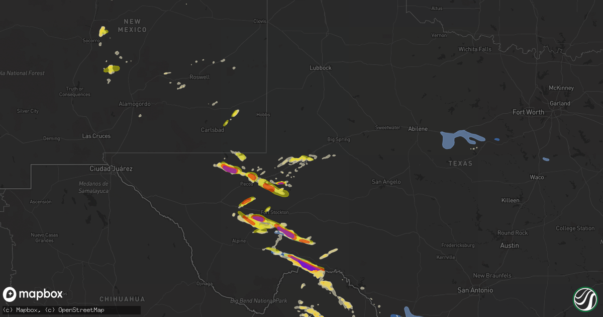
Hail Map on May 31, 2021
Get this storm
May 31 map
$229
one time, instant access
Download today. No call, no setup
Keep the $229
Bought the map and want the full workflow? Apply the entire $229 to a subscription within 7 days. None of it is wasted.
Every map, not just this one
This buys you this map. Subscription and you get every map we run, in the markets you choose from a few cities to whole states to nationwide. Plus real-time alerts the moment a storm fires.
Contact data
Name, contact info, occupancy, even credit band for addresses in the footprint. You go from where it hit to who to call.
Become the source they trust
Unlimited branding weather history reports on demand. You already have the documented answer ready for the property owner, and you are the one who showed up with it.
Property data and RoofTrace estimates
Pull up any address you have got, its value and the exact code rules for that jurisdiction, straight from One Click Code. Then RoofTrace estimates the squares, pitch, and roof value, priced the way you price.
States Impacted by Hail Map on May 31, 2021
Storm reports
Florida
| Date | Description |
|---|---|
| 05/31/20213:40 PM CDT | Storm spotter reported pea size hail and wind gusts 60 mph at 951 and rattlesnake hammock. |
| 05/31/20213:40 PM CDT | Storm spotter reported pea size hail and wind gusts 60 mph at 951 and rattlesnake hammock. |
| 05/30/202111:59 PM CDT | At 459 PM EDT, severe thunderstorms were located along a line extending from near Naples Park to near Royal Palm Hammock, moving northwest at 20 mph. HAZARD...60 mph wind gusts and quarter size hail. SOURCE...Radar indicated. IMPACT...Hail damage to vehicles is expected. Expect wind damage to roofs, siding, and trees. Locations impacted include... Naples, Marco Island, Golden Gate Estates, Naples Park and Cape Romano. |
| 05/30/202111:29 PM CDT | At 429 PM EDT, severe thunderstorms were located along a line extending from Golden Gate to near Royal Palm Hammock, moving west at 20 mph. HAZARD...60 mph wind gusts and quarter size hail. SOURCE...Radar indicated. IMPACT...Hail damage to vehicles is expected. Expect wind damage to roofs, siding, and trees. Locations impacted include... Naples, Marco Island, Golden Gate Estates, Cape Romano and Belle Meade. |
Wisconsin
| Date | Description |
|---|---|
| 05/31/20214:42 PM CDT | Hail for about 5 minutes. Most pea to nickel size... But a few stones measured 1 inch diameter. |
| 05/31/20214:39 PM CDT | Delayed photo of half-dollar size hail. Time estimated from radar. |
| 05/31/20214:35 PM CDT | A local report indicates 1.00 inch wind near EAU CLAIRE |
| 05/31/20213:45 PM CDT | Via social media. Hail covered the ground with pea to quarter size stones. |
| 05/31/20213:38 PM CDT | Mostly pea and penny sized hail. A few quarter sized. Approximately 10 minutes of hail. Minor damage to trees. Larger hail at end of shower. |
| 05/31/20212:44 PM CDT | A local report indicates 1.00 inch wind near SUGAR CAMP |
| 05/31/20211:32 AM CDT | At 632 PM CDT, a severe thunderstorm was located near Marshfield, or 22 miles northeast of Neillsville, moving east at 40 mph. HAZARD...Half dollar size hail. SOURCE...Radar indicated. IMPACT...Damage to vehicles is expected. Locations impacted include... Stevens Point, Marshfield, Spencer, Whiting, Plover, Knowlton, Stratford, Hewitt, Sherry and Auburndale. |
| 05/31/202112:00 AM CDT | At 500 PM CDT, a severe thunderstorm was located near Willow Lake, or 26 miles southeast of Park Falls, moving east at 35 mph. HAZARD...Quarter size hail. SOURCE...Radar indicated. IMPACT...Damage to vehicles is expected. This severe thunderstorm will be near... Tripoli around 510 PM CDT. Willow Reservoir around 515 PM CDT.Other locations in the path of this severe thunderstorm includeTomahawk, Woodboro, Rhinelander and Harrison. |
| 05/30/202111:54 PM CDT | At 454 PM CDT, a severe thunderstorm was located near Willow Lake, or 24 miles southeast of Park Falls, moving east at 20 mph. HAZARD...Quarter size hail. SOURCE...Radar indicated. IMPACT...Damage to vehicles is expected. This severe thunderstorm will remain over mainly rural areas of east central Price County. |
| 05/30/202111:44 PM CDT | At 443 PM CDT, a severe thunderstorm was located over Phillips, or 16 miles south of Park Falls, moving east at 15 mph. HAZARD...Half dollar size hail. SOURCE...Trained weather spotters reported 1 inch hail with this storm near the Phillips Airport. IMPACT...Damage to vehicles is expected. This severe thunderstorm will remain over mainly rural areas of central Price County, including the following locations... Musser Lake, Wilson Lake Near Phillips and Cranberry Lake. |
| 05/30/202110:27 PM CDT | At 326 PM CDT, a severe thunderstorm was located 8 miles southwest of Headwaters Wilderness, or 11 miles northwest of Crandon, moving east at 25 mph. HAZARD...Quarter size hail. SOURCE...Radar indicated. IMPACT...Damage to vehicles is expected. Locations impacted include... Rhinelander, Crandon, Newbold, Woodboro, Crystal Lake Scout Reservation, North Otter Creek Natural Area, Sugar Camp, Laona, Argonne and Armstrong Creek. |
Colorado
| Date | Description |
|---|---|
| 05/31/20213:30 PM CDT | Law enforcement reported brief tornado touchdown... With power poles knocked over. |
| 05/31/202112:35 PM CDT | A local report indicates 1.00 inch wind near 7 SE STONER |
| 05/31/20217:34 AM CDT | At 1234 PM MDT, a severe thunderstorm was located 17 miles southeast of Mancos, or 20 miles southwest of Durango, moving east at 10 mph. HAZARD...Quarter size hail. SOURCE...Radar indicated. IMPACT...Damage to vehicles is expected. This severe thunderstorm will remain over mainly rural areas of southwestern La Plata County, including the following locations... Kline, Marvel and Redmesa.This includes Colorado 140 between mile markers 3 and 12. |
| 05/31/20217:07 AM CDT | At 1206 PM MDT, a severe thunderstorm was located 10 miles west of Durango, moving east at 20 mph. HAZARD...Quarter size hail. SOURCE...Radar indicated. IMPACT...Damage to vehicles is expected. This severe thunderstorm will remain over mainly rural areas of central La Plata County, including the following locations... Mayday.This includes U.S. Highway 160 in Colorado between mile markers 68and 73. |
Michigan
| Date | Description |
|---|---|
| 05/31/20211:30 PM CDT | Delayed report of quarter to half dollar size hail that covered the ground and dented a truck. |
| 05/31/202112:15 PM CDT | Hail accumulation on hwy-41 up to an inch in depth. |
| 05/31/20217:43 AM CDT | At 1242 PM EDT, a severe thunderstorm was located near Kenton, or 22 miles southwest of Baraga, moving east at 25 mph. HAZARD...60 mph wind gusts and quarter size hail. SOURCE...Radar indicated. IMPACT...Hail damage to vehicles is expected. Expect wind damage to roofs, siding, and trees. Locations impacted include... Sidnaw. |
| 05/31/20217:36 AM CDT | At 1235 PM EDT, a severe thunderstorm was located over Nisula, or 14 miles west of Baraga, moving east at 20 mph. HAZARD...60 mph wind gusts and quarter size hail. SOURCE...Radar indicated. IMPACT...Hail damage to vehicles is expected. Expect wind damage to roofs, siding, and trees. This severe thunderstorm will remain over mainly rural areas of west central Houghton and west central Baraga Counties, including the following locations... Alston, Pelkie and Prickett Dam. |
| 05/30/20218:09 PM CDT | At 109 PM EDT, a severe thunderstorm was located over Alberta, or near L'anse, moving east at 25 mph. HAZARD...60 mph wind gusts and quarter size hail. SOURCE...Radar indicated. IMPACT...Hail damage to vehicles is expected. Expect wind damage to roofs, siding, and trees. Locations impacted include... Three Lakes. |
Texas
| Date | Description |
|---|---|
| 05/31/20215:35 PM CDT | 2 inch hail reported at sand hills oil field. |
| 05/31/20214:38 PM CDT | Spotter reports hail up to 1.25 inches. |
| 05/31/20214:04 PM CDT | 10 miles east northeast of fort stockton along 285 report of quarter size hail. |
| 05/31/20213:43 PM CDT | This tornado lasted approximately 8 minutes between 0339 pm cdt and 0347 pm cdt before spotters lost visual. Tornado remained over rural pecos county and no damage was |
| 05/31/20213:29 PM CDT | Spotters reported a tornado that lifted and touched down multiple times over 16 mintues from 0321 pm cdt to 0337 pm cdt. Tornado remained over rural pecos county and no |
| 05/31/20213:26 PM CDT | A local report indicates a tornado near 15 S FORT STOCKTON |
| 05/31/20213:10 PM CDT | A local report indicates 1.50 inch wind near 11 WSW BELDING |
| 05/31/20212:35 PM CDT | Lifted sheet metal roofing material and downed trees were reported on cr479 and at the intersection of cr570 and cr571. |
| 05/31/202111:16 AM CDT | Reported to be covering the ground. |
| 05/31/202110:47 AM CDT | Estimated to have lasted for five minutes. |
| 05/31/20217:58 AM CDT | At 1258 AM CDT, a severe thunderstorm was located 7 miles southwest of Clairemont, or 13 miles east of Lake Alan Henry, moving northeast at 25 mph. HAZARD...60 mph wind gusts and quarter size hail. SOURCE...Radar indicated. IMPACT...Hail damage to vehicles is expected. Expect wind damage to roofs, siding, and trees. Locations impacted include... Jayton and Clairemont. |
| 05/31/20217:47 AM CDT | At 1247 AM CDT, a severe thunderstorm was located 5 miles east of Quail, or 6 miles northwest of Wellington, moving northeast at 20 mph. HAZARD...60 mph wind gusts and quarter size hail. SOURCE...Radar indicated. IMPACT...Minor damage to roofs, siding, and trees is possible. Hail damage to vehicles is expected. Locations impacted include... Wellington, Lutie, Quail and Samnorwood. |
| 05/31/20217:06 AM CDT | At 1205 AM CDT, a severe thunderstorm was located 7 miles north of Justiceburg, or 10 miles northwest of Lake Alan Henry, moving northeast at 25 mph. HAZARD...Ping pong ball size hail and 60 mph wind gusts. SOURCE...Radar indicated. IMPACT...People and animals outdoors will be injured. Expect hail damage to roofs, siding, windows, and vehicles. Expect wind damage to roofs, siding, and trees. Locations impacted include... Justiceburg. |
| 05/31/20216:26 AM CDT | At 1125 AM CDT, a severe thunderstorm was located near Midland International Air and Space Port, or 9 miles southwest of Midland, moving east at 25 mph. HAZARD...70 mph wind gusts and half dollar size hail. SOURCE...Radar indicated. IMPACT...Hail damage to vehicles is expected. Expect considerable tree damage. Wind damage is also likely to mobile homes, roofs, and outbuildings. Locations impacted include... Midland, Odessa, Greenwood, Stanton, Midland International Air and Space Port, Cotton Flat, Warfield, Midland Airpark, Skywest Airport, Courtney, Stanton Municipal Aiport, Spraberry and Odessa Schlemeyer Field.This includes Interstate 20 between mile markers 116 and 160. |
| 05/31/20216:15 AM CDT | At 1115 PM CDT, severe thunderstorms were located along a line extending from 6 miles southwest of Standart to 9 miles southwest of Spofford to Quemado, moving east at 20 mph. HAZARD...60 mph wind gusts and quarter size hail. SOURCE...Radar indicated. IMPACT...Hail damage to vehicles is expected. Expect wind damage to roofs, siding, and trees. Locations impacted include... Brackettville, Spofford, Quemado, Paloma, Anacacho, Radar Base, Normandy, Darling, Fort Clark Springs and Laughlin AFB Aux Field. |
| 05/31/20215:31 AM CDT | At 1031 AM CDT, a severe thunderstorm was located near West Odessa, or 11 miles west of Odessa, moving northeast at 30 mph. HAZARD...60 mph wind gusts and quarter size hail. SOURCE...Radar indicated. IMPACT...Hail damage to vehicles is expected. Expect wind damage to roofs, siding, and trees. Locations impacted include... Midland, Odessa, Goldsmith, Midland International Air and Space Port, West Odessa, Odessa Schlemeyer Field, Notrees, Penwell, Warfield and Midland Airpark.This includes Interstate 20 between mile markers 98 and 142. |
| 05/31/20214:23 AM CDT | At 923 PM CDT, a severe thunderstorm was located over Lake View, or 8 miles northwest of Del Rio, moving east at 10 mph. HAZARD...60 mph wind gusts and quarter size hail. SOURCE...Radar indicated. IMPACT...Hail damage to vehicles is expected. Expect wind damage to roofs, siding, and trees. Locations impacted include... Del Rio, Lake View, Amistad Village, Black Brush Point, Laughlin AFB, Val Verde Park, Diablo East, Cienegas Terrace, Governors Landing, Long Point, 277 South Boat Ramp, 277 North Campground, San Pedro Canyon, Spur 406 Campground, Escondido Estates and Lake Ridge Ranch. |
| 05/31/20211:50 AM CDT | At 650 PM CDT, a severe thunderstorm was located 12 miles northeast of Saragosa, or 22 miles south of Pecos, moving northeast at 30 mph. HAZARD...Golf ball size hail and 60 mph wind gusts. SOURCE...Radar indicated. IMPACT...People and animals outdoors will be injured. Expect hail damage to roofs, siding, windows, and vehicles. Expect wind damage to roofs, siding, and trees. Locations impacted include... Verhalen, Toyah Lake, Coyanosa and B F Goodrich Testing Track. This includes Interstate 10 between mile markers 215 and 225. |
| 05/31/20211:49 AM CDT | At 649 PM CDT, a severe thunderstorm was located 27 miles north of Marathon, or 28 miles southwest of Fort Stockton, moving east at 30 mph. HAZARD...60 mph wind gusts and half dollar size hail. SOURCE...Radar indicated. IMPACT...Hail damage to vehicles is expected. Expect wind damage to roofs, siding, and trees. Locations impacted include... Sierra Madera. |
| 05/31/202112:59 AM CDT | At 559 PM CDT, a severe thunderstorm was located 15 miles southeast of Balmorhea Lake, or 20 miles northeast of Fort Davis, moving southeast at 15 mph. HAZARD...60 mph wind gusts and half dollar size hail. SOURCE...Radar indicated. IMPACT...Hail damage to vehicles is expected. Expect wind damage to roofs, siding, and trees. Locations impacted include... Balmorhea Lake and Saragosa. This includes Interstate 10 between mile markers 211 and 222. |
| 05/31/202112:58 AM CDT | At 558 PM CDT, a severe thunderstorm was located 18 miles northeast of Sanderson, moving east at 25 mph. HAZARD...Two inch hail and 70 mph wind gusts. SOURCE...Radar indicated. IMPACT...People and animals outdoors will be injured. Expect hail damage to roofs, siding, windows, and vehicles. Expect considerable tree damage. Wind damage is also likely to mobile homes, roofs, and outbuildings. Locations impacted include... Terrell County Gas Plant. |
| 05/31/202112:52 AM CDT | At 551 AM CDT, a severe thunderstorm was located 20 miles north of Kent, moving east at 45 mph. HAZARD...60 mph wind gusts and quarter size hail. SOURCE...Radar indicated. IMPACT...Hail damage to vehicles is expected. Expect wind damage to roofs, siding, and trees. Locations impacted include... Pecos, Toyah, Toyah Lake and Pecos Municipal Airport. This includes Interstate 20 between mile markers 13 and 45. |
| 05/31/202112:12 AM CDT | At 512 PM CDT, a severe thunderstorm was located 10 miles west of Grandfalls, or 16 miles southwest of Monahans, moving east at 25 mph. HAZARD...Ping pong ball size hail and 60 mph wind gusts. SOURCE...Radar indicated. IMPACT...People and animals outdoors will be injured. Expect hail damage to roofs, siding, windows, and vehicles. Expect wind damage to roofs, siding, and trees. Locations impacted include... Monahans, Grandfalls, Royalty, Imperial and Imperial Reservoir. |
| 05/31/202112:01 AM CDT | At 501 AM CDT, a severe thunderstorm was located 14 miles northwest of Plateau, or 17 miles northeast of Van Horn, moving east at 25 mph. HAZARD...60 mph wind gusts and quarter size hail. SOURCE...Radar indicated. IMPACT...Hail damage to vehicles is expected. Expect wind damage to roofs, siding, and trees. This severe thunderstorm will remain over mainly rural areas of central Culberson County. |
| 05/30/202111:36 PM CDT | At 436 PM CDT, a severe thunderstorm was located 28 miles north of Sanderson, moving east at 25 mph. This is a very dangerous storm. HAZARD...Baseball size hail. SOURCE...Radar indicated. IMPACT...People and animals outdoors will be severely injured. Expect shattered windows, extensive damage to roofs, siding, and vehicles. This severe thunderstorm will remain over mainly rural areas of southeastern Pecos and north central Terrell Counties. |
| 05/30/202111:25 PM CDT | At 424 PM CDT, severe thunderstorms were located along a line extending from near Pecan Plantation to 6 miles southwest of Cleburne State Park to near Cranfills Gap, moving east at 35 mph. HAZARD...60 mph wind gusts and penny size hail. SOURCE...Radar indicated. IMPACT...Expect damage to roofs, siding, and trees. Locations impacted include... Mansfield, Burleson, Cleburne, Hillsboro, Granbury, Keene, Joshua, Alvarado, Clifton, Pecan Plantation, Venus, Whitney, Itasca, Grandview, Meridian, Godley, Blum, Cranfills Gap, Covington and Cross Timber.This includes the following highways... Interstate 35 between mile markers 355 and 369. Interstate 35W between mile markers 1 and 35. Interstate 35E near mile marker 371. |
| 05/30/202111:12 PM CDT | At 412 PM CDT, a severe thunderstorm was located near Barstow, or 13 miles northeast of Pecos, moving southeast at 20 mph. HAZARD...Two inch hail and 70 mph wind gusts. SOURCE...Radar indicated. IMPACT...People and animals outdoors will be injured. Expect hail damage to roofs, siding, windows, and vehicles. Expect considerable tree damage. Wind damage is also likely to mobile homes, roofs, and outbuildings. Locations impacted include... Monahans, Thorntonville, Barstow, Pyote, Wickett and B F Goodrich Testing Track.This includes Interstate 20 between mile markers 46 and 79. |
| 05/30/202111:09 PM CDT | At 409 AM CDT, a severe thunderstorm was located 9 miles northeast of Allamoore, moving northeast at 40 mph. HAZARD...60 mph wind gusts and quarter size hail. SOURCE...Radar indicated. IMPACT...Hail damage to vehicles is expected. Expect wind damage to roofs, siding, and trees. Locations impacted include... Van Horn and Culberson County Airport. This includes Interstate 10 between mile markers 136 and 138. |
| 05/30/202110:51 PM CDT | At 351 PM CDT, a severe thunderstorm was located 7 miles northwest of Fort Stockton, moving northeast at 30 mph. HAZARD...60 mph wind gusts and half dollar size hail. SOURCE...Radar indicated. IMPACT...Hail damage to vehicles is expected. Expect wind damage to roofs, siding, and trees. Locations impacted include... Fort Stockton, Firestone Test Track, Imperial and Fort Stockton-Pecos County Airport.This includes Interstate 10 between mile markers 245 and 286. |
| 05/30/202110:42 PM CDT | At 342 AM CDT, a severe thunderstorm was located near Sagerton, moving east at 25 mph. HAZARD...60 mph wind gusts and quarter size hail. SOURCE...Radar indicated. IMPACT...Hail damage to vehicles is expected. Expect wind damage to roofs, siding, and trees. This severe thunderstorm will be near... Sagerton around 350 AM CDT. Paint Creek around 425 AM CDT. Stamford and Lake Stamford Marina around 435 AM CDT.Other locations impacted by this severe thunderstorm include Tuxedo. |
| 05/30/202110:28 PM CDT | At 326 PM CDT, severe thunderstorms were located along a line extending from 9 miles west of Lipan to near Stephenville to near Dublin, moving east at 30 mph. HAZARD...60 mph wind gusts and penny size hail. SOURCE...Radar indicated. IMPACT...Expect damage to roofs, siding, and trees. Locations impacted include... Stephenville, Granbury, Dublin, Pecan Plantation, Glen Rose, Hico, Lipan, Iredell, Dinosaur Valley State Park, Morgan Mill, Oak Trail Shores, Walnut Springs and Tolar. |
| 05/30/202110:26 PM CDT | At 325 AM CDT, a severe thunderstorm was located over Aspermont, moving east at 25 mph. HAZARD...60 mph wind gusts and penny size hail. SOURCE...Radar indicated. IMPACT...Expect damage to roofs, siding, and trees. Locations impacted include... Aspermont, Old Glory and Us-380 Near The Haskell- Stonewall County Line. |
| 05/30/202110:18 PM CDT | At 316 PM CDT, a severe thunderstorm was located 16 miles southwest of Fort Stockton, moving east at 25 mph. HAZARD...Tennis ball size hail and 60 mph wind gusts. SOURCE...Radar indicated. IMPACT...People and animals outdoors will be injured. Expect hail damage to roofs, siding, windows, and vehicles. Expect wind damage to roofs, siding, and trees. Locations impacted include... Sierra Madera. |
| 05/30/202110:17 PM CDT | At 317 PM CDT/217 PM MDT/, severe thunderstorms were located along a line extending from 15 miles north of Mentone to 8 miles southeast of Orla, moving southeast at 30 mph. These are very dangerous storms. HAZARD...Baseball size hail and 60 mph wind gusts. SOURCE...Radar indicated. IMPACT...People and animals outdoors will be severely injured. Expect shattered windows, extensive damage to roofs, siding, and vehicles. Locations impacted include... Pecos, Wink, Mentone, Barstow, Pecos Municipal Airport, Slash Ranch and Winkler County Airport.This includes Interstate 20 between mile markers 27 and 45, andbetween mile markers 51 and 52. |
| 05/30/202110:04 PM CDT | At 303 PM CDT, severe thunderstorms were located along a line extending from De Leon to near Blanket, moving east at 20 mph. HAZARD...60 mph wind gusts and penny size hail. SOURCE...Radar indicated. IMPACT...Expect damage to roofs, siding, and trees. Locations impacted include... Comanche, Dublin, De Leon and Gustine. |
| 05/30/20219:40 PM CDT | At 239 AM MDT, a severe thunderstorm was located 10 miles northwest of Frenchman Canyon, moving northeast at 25 mph. Storm has increased in intensity. HAZARD...Ping pong ball size hail and 60 mph wind gusts. SOURCE...Radar indicated. IMPACT...People and animals outdoors will be injured. Expect hail damage to roofs, siding, windows, and vehicles. Expect wind damage to roofs, siding, and trees. Locations impacted include... Allamoore and Frenchman Canyon. This includes Interstate 10 in Texas between mile markers 111 and134. |
| 05/30/20219:30 PM CDT | At 230 PM CDT, a severe thunderstorm was located 24 miles southeast of Saragosa, or 27 miles west of Fort Stockton, moving east at 40 mph. HAZARD...70 mph wind gusts and ping pong ball size hail. SOURCE...Radar indicated. IMPACT...People and animals outdoors will be injured. Expect hail damage to roofs, siding, windows, and vehicles. Expect considerable tree damage. Wind damage is also likely to mobile homes, roofs, and outbuildings. Locations impacted include... Fort Stockton, Fort Stockton-Pecos County Airport and Firestone Test Track.This includes Interstate 10 between mile markers 237 and 271. |
| 05/30/20219:30 PM CDT | At 230 PM CDT, severe thunderstorms were located along a line extending from 6 miles southeast of Necessity to near Gorman, moving east at 25 mph. HAZARD...65 mph wind gusts. SOURCE...Radar indicated. IMPACT...Expect damage to roofs, siding, and trees. Locations impacted include... Stephenville, Eastland, Ranger, De Leon, Gorman, Gordon, Huckabay, Morgan Mill, Strawn and Mingus.This includes Interstate 20 between mile markers 343 and 389. |
| 05/30/20219:26 PM CDT | At 226 AM CDT, a severe thunderstorm was located 9 miles south of Jayton, moving east at 35 mph. HAZARD...60 mph wind gusts and nickel size hail. SOURCE...Radar indicated. IMPACT...Expect damage to roofs, siding, and trees. Locations impacted include... Aspermont, Peacock, Old Glory, Swenson and Us-380 Near The Haskell- Stonewall County Line. |
| 05/30/20219:06 PM CDT | At 205 PM CDT, severe thunderstorms were located along a line extending from Eastland to near Cross Cut, moving east at 35 mph. HAZARD...60 mph wind gusts. SOURCE...Radar indicated. IMPACT...Expect damage to roofs, siding, and trees. Locations impacted include... Eastland, Gorman, Rising Star and Carbon. This includes Interstate 20 between mile markers 334 and 347. |
| 05/30/20218:59 PM CDT | At 159 PM CDT, a severe thunderstorm was located over Atwell, moving southeast at 35 mph. HAZARD...60 mph wind gusts. SOURCE...Radar indicated. IMPACT...Expect damage to roofs, siding, and trees. This severe thunderstorm will be near... Cross Plains around 210 PM CDT. May around 240 PM CDT. Blanket around 300 PM CDT.Other locations impacted by this severe thunderstorm include Owens,Thrifty, Echo and Admiral. |
| 05/30/20217:18 PM CDT | Spotter reports nickel to quarter size hail 20 miles south of fort stockon on 285. |
New Mexico
| Date | Description |
|---|---|
| 05/31/20213:08 PM CDT | Coors bypass blvd nw and coors blvd nw |
| 05/31/20212:59 PM CDT | Golf course and 20th ave. |
| 05/31/20212:52 PM CDT | A local report indicates 1.00 inch wind near 2 SSE RIO RANCHO |
| 05/31/20212:04 PM CDT | South of hwy 380 near mm 7 |
| 05/31/20217:15 AM CDT | At 1214 PM MDT, a severe thunderstorm was located 19 miles east of Avalon, or 22 miles northeast of Carlsbad, moving northeast at 20 mph. HAZARD...60 mph wind gusts and quarter size hail. SOURCE...Radar indicated. IMPACT...Hail damage to vehicles is expected. Expect wind damage to roofs, siding, and trees. Locations impacted include... Maljamar and Halfway. |
| 05/31/20217:03 AM CDT | At 1203 PM MDT, a severe thunderstorm was located near Bingham, or 28 miles northwest of Carrizozo, moving northeast at 10 mph. HAZARD...60 mph wind gusts and quarter size hail. SOURCE...Radar indicated. IMPACT...Hail damage to vehicles is expected. Expect wind damage to roofs, siding, and trees. Locations impacted include... Bingham.This includes Highway 380 between Mile Markers 24 and 44. |
| 05/31/20212:19 AM CDT | At 718 AM MDT, a severe thunderstorm was located 17 miles northwest of Bitter Lake Wildlife Refuge, or 21 miles north of Roswell, moving northeast at 20 mph. HAZARD...60 mph wind gusts and quarter size hail. SOURCE...Radar indicated. IMPACT...Hail damage to vehicles is expected. Expect wind damage to roofs, siding, and trees. This severe thunderstorm will remain over mainly rural areas of north central Chaves County.This includes Highway 285 between Mile Markers 124 and 136. |
| 05/31/202112:08 AM CDT | At 508 PM MDT, a severe thunderstorm was located 13 miles northwest of Loco Hills, or 16 miles northeast of Artesia, moving northeast at 20 mph. HAZARD...60 mph wind gusts and quarter size hail. SOURCE...Radar indicated. IMPACT...Hail damage to vehicles is expected. Expect wind damage to roofs, siding, and trees. This severe thunderstorm will remain over mainly rural areas of east central Chaves County. |
| 05/31/202112:05 AM CDT | At 504 PM MDT, a severe thunderstorm was located 12 miles east of Artesia, moving northeast at 20 mph. HAZARD...Tennis ball size hail and 70 mph wind gusts. SOURCE...Radar indicated. IMPACT...People and animals outdoors will be injured. Expect hail damage to roofs, siding, windows, and vehicles. Expect considerable tree damage. Wind damage is also likely to mobile homes, roofs, and outbuildings. This severe thunderstorm will remain over mainly rural areas of northeastern Eddy County. |
| 05/31/202112:00 AM CDT | At 459 PM MDT, a severe thunderstorm was located 6 miles west of Timberon, moving east at 10 mph. HAZARD...60 mph wind gusts and quarter size hail. SOURCE...Radar indicated. IMPACT...Hail damage to vehicles is expected. Expect wind damage to roofs, siding, and trees. Locations impacted include... Timberon. |
| 05/30/20219:44 PM CDT | At 244 PM CDT/144 PM MDT/, severe thunderstorms were located along a line extending from 16 miles northeast of Red Bluff Reservoir to 12 miles west of Orla, moving east at 20 mph. HAZARD...60 mph wind gusts and quarter size hail. SOURCE...Radar indicated. IMPACT...Hail damage to vehicles is expected. Expect wind damage to roofs, siding, and trees. Locations impacted include... Red Bluff Reservoir, Orla, Slash Ranch and Red Bluff. |
| 05/30/20218:59 PM CDT | At 158 PM MDT, a severe thunderstorm was located 14 miles southeast of La Joya, or 18 miles northeast of Socorro, and is nearly stationary. HAZARD...60 mph wind gusts and half dollar size hail. SOURCE...Radar indicated. IMPACT...Hail damage to vehicles is expected. Expect wind damage to roofs, siding, and trees. This severe thunderstorm will remain over mainly rural areas of central Socorro County. |
| 05/30/20218:56 PM CDT | At 155 PM MDT, severe thunderstorms were located along a line extending from Rio Rancho to near South Valley, moving northeast at 10 mph. HAZARD...60 mph wind gusts and quarter size hail. SOURCE...Radar indicated. IMPACT...Hail damage to vehicles is expected. Expect wind damage to roofs, siding, and trees. Locations impacted include... Albuquerque, Los Lunas, Los Ranchos De Albuquerque, Bosque Farms, Peralta, South Valley, North Valley, Isleta Pueblo and Alameda.This includes the following highways... Interstate 40 between Mile Markers 150 and 168. Interstate 25 between Mile Markers 204 and 235. |
| 05/30/20218:38 PM CDT | At 138 PM MDT, severe thunderstorms were located along a line extending from near Mariposa to Albuquerque, moving northeast at 10 mph. HAZARD...60 mph wind gusts and half dollar size hail. SOURCE...Radar indicated. IMPACT...Hail damage to vehicles is expected. Expect wind damage to roofs, siding, and trees. Locations impacted include... Northern Albuquerque, Rio Rancho, Corrales, Bernalillo, Enchanted Hills, Mariposa, Cabezon, Coronado State Monument, Vista Hills and Sandia Pueblo.This includes the following highways... Interstate 25 between Mile Markers 236 and 243. Highway 550 between Mile Markers 1 and 14. |
| 05/30/20218:24 PM CDT | At 124 PM MDT, severe thunderstorms were located along a line extending from 19 miles south of Bingham to 22 miles southeast of Bosque Del Apache Refuge, and are nearly stationary. HAZARD...60 mph wind gusts and half dollar size hail. SOURCE...Radar indicated. IMPACT...Hail damage to vehicles is expected. Expect wind damage to roofs, siding, and trees. These severe thunderstorms will remain over mainly rural areas of west central Lincoln and southeastern Socorro Counties. |
| 05/30/20218:05 PM CDT | At 105 PM MDT, a severe thunderstorm was located near San Ysidro, or 18 miles northwest of Rio Rancho, moving east at 10 mph. HAZARD...60 mph wind gusts and quarter size hail. SOURCE...Radar indicated. IMPACT...Hail damage to vehicles is expected. Expect wind damage to roofs, siding, and trees. Locations impacted include... San Ysidro, Zia Pueblo and Jemez Pueblo. This includes Highway 550 between Mile Markers 8 and 31. |
Cities Impacted by Hail Map on May 31, 2021
- Barstow, TX
- Lanse, MI
- Fort Stockton, TX
- Eagle Pass, TX
- Marathon, TX
- Hatley, WI
- Hebbronville, TX
- Coyanosa, TX
- Grandfalls, TX
- Monahans, TX
- Odessa, TX
- Sanibel, FL
- Goldsmith, TX
- West Concord, MN
- Socorro, NM
- Hondo, NM
- Tinnie, NM
- Realitos, TX
- Dryden, TX
- Altoona, WI
- Eau Claire, WI
- Balmorhea, TX
- Maljamar, NM
- Spencer, WI
- Marshfield, WI
- Rio Rancho, NM
- Michigamme, MI
- Champion, MI
- Pecos, TX
- Estancia, NM
- Midland, TX
- Asherton, TX
- Chatham, MI
- Emmons, MN
- Northwood, IA
- Pyote, TX
- Mentone, TX
- Laredo, TX
- Stockholm, WI
- Menomonie, WI
- Rock, MI
- Albuquerque, NM
- Kellogg, MN
- Pelkie, MI
- Covington, MI
- Fort Davis, TX
- Mondovi, WI
- Elk Mound, WI
- Crystal City, TX
- Crane, TX
- Comstock, TX
- Phillips, WI
- Peralta, NM
- Bosque Farms, NM
- Isleta, NM
- Carrizo Springs, TX
- Lake Mills, IA
- Corrales, NM
- Ishpeming, MI
- Cotulla, TX
- Cloudcroft, NM
- Naples, FL
- Zumbro Falls, MN
- Lake City, MN
- Imperial, TX
- Boyd, WI
- Chippewa Falls, WI
- Cadott, WI
- Fall Creek, WI
- Stanley, WI
- Augusta, WI
- Garden City, TX
- De Leon, TX
- Salt Flat, TX
- Bruni, TX
- Rochester, MN
- Del Rio, TX
- Durango, CO
- Thoreau, NM
- Truth Or Consequences, NM
- Gleason, WI
- Roswell, NM
- Encinal, TX
- Espanola, NM
- Bernalillo, NM
- Nelson, WI
- Quemado, TX
- Brantwood, WI
- Republic, MI
- Nisula, MI
- Merrill, WI
- Santa Fe, NM
- Rhinelander, WI
- Medford, WI
- Wink, TX
- Eagle River, WI
- Irma, WI
- Woodruff, WI
- Minocqua, WI
- Trout Creek, MI
- Albert Lea, MN
- Glenville, MN
- Plainview, MN
- Carlsbad, NM
- Mancos, CO
- Carbon, TX
- Ranger, TX
- Baird, TX
- Cross Plains, TX
- Desdemona, TX
- Rising Star, TX
- Cisco, TX
- Gorman, TX
- Stephenville, TX
- Dublin, TX
- Eastland, TX
- Bluff Dale, TX
- Hubbard, TX
- Penelope, TX
- Hillsboro, TX
- Batesville, TX
- Pearsall, TX
- La Pryor, TX
- Dilley, TX
- Catarina, TX
- Three Lakes, WI