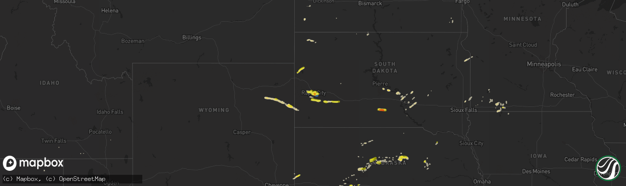
Hail Map on May 29, 2023
The weather event on May 29, 2023 includes Hail and Wind maps. 14 states and 257 cities were impacted and suffered possible damage. The total estimated number of properties impacted is 58,954.
Want more than just the map?
Turn this storm into a full workflow.
- Owner + property data so you know who to knock
- OnDemand branded weather history reports to win the "did we even have hail?" argument
- RoofTrace estimate so reps stop guessing numbers at the door
Bought this map? Upgrade within 7 days and we'll credit the $230. (10-15 min setup call)
Hail
Wind
58,954
Estimated number of impacted properties by a 1.00" hail or larger7,104
Estimated number of impacted properties by a 1.75" hail or larger0
Estimated number of impacted properties by a 2.50" hail or largerStates Impacted by Hail Map on May 29, 2023
Storm reports
Colorado
| Date | Description |
|---|---|
| 05/29/20236:54 PM CDT | Report via social media. |
| 05/28/202311:13 PM CDT | Asos station klhx la junta airport. |
| 05/28/20237:38 PM CDT | Ended at 640 pm. |
Texas
| Date | Description |
|---|---|
| 05/29/20235:28 PM CDT | Estimated from public and matches with radar estimate. Time estimated with radar return of golf ball size hail. |
| 05/29/20234:42 PM CDT | Relayed from public via fb accounts. Matches with radar estimates as well. Time estimated from radar. Near cr 303 and hwy 44. |
| 05/28/20238:20 PM CDT | Public report via social media of 2-inch hail in hidalgo. Time estimated by radar. |
| 05/28/20238:10 PM CDT | Public sent pictures of estimated hen egg sized hail near granjeno... Tx to local media. |
| 05/28/20237:42 PM CDT | Estimated quarter to ping pong size hail in a video from the public sent to local media near encino... Tx. |
Kansas
| Date | Description |
|---|---|
| 05/29/202312:35 AM CDT | 12 inch tree limb broke off tree. Time is radar approximated. Also had event total rainfall of 0.57 inches. |
Nebraska
| Date | Description |
|---|---|
| 05/29/20236:45 PM CDT | Trained spotter reports quarter sized hail near thedford. |
| 05/29/20236:35 PM CDT | A local report indicates 1.00 inch wind near 2 E THEDFORD |
| 05/29/20235:00 PM CDT | Social media report of quarter sized hail 1 mi n of roscoe. |
| 05/28/20238:17 PM CDT | Cwop reports wind gust of 59 mph. |
| 05/28/20238:17 PM CDT | Corrects previous tstm wnd gst report from 5 ssw north platte. Mesonet reports 75 mph wind gust for a time of 817p. |
| 05/28/20238:15 PM CDT | Mesonet reports 75 mph wind gust. |
| 05/28/20238:15 PM CDT | Corrects previous tstm wnd gst report from 4 ssw north platte. Cwop reports wind gust of 59 mph for time of 815p. |
| 05/28/20238:12 PM CDT | A local report indicates 1.00 inch wind near 8 NE BARTLETT |
| 05/28/20237:55 PM CDT | Trained spotter reports quarter sized hail. |
| 05/28/20237:08 PM CDT | Trained spotter reports quarter sized hail via social media photos. |
| 05/28/20237:00 PM CDT | Quarter sized hail reported by sheriff. |
South Dakota
| Date | Description |
|---|---|
| 05/29/20236:05 PM CDT | A local report indicates 1.00 inch wind near 13 SSW QUINN |
| 05/29/20233:50 PM CDT | A local report indicates 58 MPH wind near RAPID CITY ARPT |
| 05/29/20233:35 PM CDT | A local report indicates 1.25 inch wind near 2 ENE DWTN RAPID CITY |
| 05/29/20233:32 PM CDT | A local report indicates 1.00 inch wind near BOX ELDER |
| 05/29/20233:30 PM CDT | A local report indicates 1.00 inch wind near HERMOSA |
| 05/29/20233:28 PM CDT | A local report indicates 1.00 inch wind near 1 E DWTN RAPID CITY |
| 05/29/20233:25 PM CDT | A local report indicates 1.00 inch wind near 4 WNW RAPID CITY ARPT |
| 05/29/20233:24 PM CDT | Mostly dimes. A few quarters. |
| 05/29/20233:23 PM CDT | A local report indicates 1.25 inch wind near 1 N DWTN RAPID CITY |
| 05/29/20233:04 PM CDT | A local report indicates 1.00 inch wind near BLACK HAWK |
| 05/29/20232:52 PM CDT | A local report indicates 1.00 inch wind near JOHNSON SIDING |
| 05/28/20237:48 PM CDT | A local report indicates 1.00 inch wind near 11 NNW WITTEN |
Minnesota
| Date | Description |
|---|---|
| 05/28/20237:10 PM CDT | Delayed social media report with pictures of 1 inch hail with lots of penny to nickels mixed. Reported that the hail fell from 7:10 to 7:30pm. |
Wyoming
| Date | Description |
|---|---|
| 05/29/20235:12 PM CDT | A local report indicates 60 MPH wind near 13 NNE WRIGHT |
Cities Impacted by Hail Map on May 29, 2023
- Rapid City, SD
- Keystone, SD
- Black Hawk, SD
- Hermosa, SD
- Belle Fourche, SD
- Box Elder, SD
- Bushnell, NE
- Harrisburg, NE
- Caputa, SD
- Boerne, TX
- San Diego, TX
- Hunt, TX
- Thedford, NE
- Seneca, NE
- Scenic, SD
- Concepcion, TX
- Alice, TX
- Ogallala, NE
- Burwell, NE
- New Ulm, TX
- Bellville, TX
- Bleiblerville, TX
- Industry, TX
- Mercedes, TX
- Edcouch, TX
- Wall, SD
- Orange Grove, TX
- Sandia, TX
- Wolf Point, MT
- Medora, ND
- Elbert, CO
- Elizabeth, CO
- Harper, TX
- Towner, ND
- Hockley, TX
- Edna, TX
- Hazen, ND
- Cambridge, KS
- Llano, TX
- Halliday, ND
- Heron Lake, MN
- Golden Valley, ND
- Dunn Center, ND
- Cartwright, ND
- Grover, CO
- Cherokee, TX
- Tow, TX
- Donnybrook, ND
- Carpio, ND
- Doss, TX
- Fredericksburg, TX
- Killdeer, ND
- Madrid, NE
- Beulah, ND
- Kerrville, TX
- Ingram, TX
- Junction, TX
- Buffalo, SD
- Comfort, TX
- Pipe Creek, TX
- Stanley, ND
- Pontotoc, TX
- Center Point, TX
- Gillette, WY
- Valley Spring, TX
- Ranger, TX
- Tracy, MN
- Hampden, ND
- Waller, TX
- Vida, MT
- Wynnewood, OK
- Upton, WY
- Mason, TX
- Rhame, ND
- Pine Bluffs, WY
- Winnsboro, TX
- Deadwood, SD
- Carpenter, WY
- San Saba, TX
- Madisonville, TX
- Okabena, MN
- Lakefield, MN
- Ludlow, SD
- Buchanan Dam, TX
- Bluffton, TX
- Purcell, OK
- Fairfield, ND
- Mullen, NE
- Midway, TX
- Stonewall, TX
- Hempstead, TX
- Cheyenne, WY
- Santa Rosa, TX
- Harlingen, TX
- Falfurrias, TX
- Creighton, NE
- Taylor, NE
- Tryon, NE
- Lyford, TX
- Wood, SD
- Brighton, CO
- Newcastle, WY
- Winner, SD
- Encino, TX
- Hebbronville, TX
- Mcallen, TX
- Mission, TX
- Calhan, CO
- Rio Grande City, TX
- Witten, SD
- Pueblo, CO
- Fountain, CO
- Hidalgo, TX
- Pharr, TX
- Elgin, NE
- Santa Elena, TX
- Paxton, NE
- Sutherland, NE
- Garciasville, TX
- Roma, TX
- Boone, CO
- Avondale, CO
- Fowler, CO
- Olney Springs, CO
- Jackson, MN
- Ordway, CO
- Poth, TX
- Falls City, TX
- Rugby, ND
- Lancaster, TX
- Red Oak, TX
- Ferris, TX
- Reva, SD
- Kountze, TX
- Knippa, TX
- Quincy, CA
- Woonsocket, SD
- Campbellton, TX
- Jetersville, VA
- Big Springs, NE
- Brule, NE
- Corrigan, TX
- Odin, MN
- Mountain Lake, MN
- Alpha, MN
- Premont, TX
- Kimball, SD
- Platte, SD
- Windom, MN
- Eldorado, TX
- Gladstone, NM
- Medina, TX
- Chamberlain, SD
- Stockdale, TX
- Floresville, TX
- Lemoyne, NE
- Warren, TX
- Halsey, NE
- Edgemont, SD
- Leakey, TX
- Haxtun, CO
- Round Lake, MN
- Kimball, NE
- Hondo, TX
- Jourdanton, TX
- Savage, MT
- Concan, TX
- Silsbee, TX
- Estherville, IA
- Luverne, MN
- Dell Rapids, SD
- Lewellen, NE
- Clearwater, NE
- Ewing, NE
- Weimar, TX
- Columbus, TX
- Spirit Lake, IA
- McLaughlin, SD
- Valentine, NE
- Colorado Springs, CO
- Primrose, NE
- Spalding, NE
- Albion, NE
- Bonham, TX
- Livingston, TX
- Goodrich, TX
- Pleasanton, TX
- Benavides, TX
- Mico, TX
- Fulda, MN
- Julesburg, CO
- Ovid, CO
- Cuero, TX
- Yoakum, TX
- Lake Park, IA
- Yuma, CO
- Westwood, CA
- Edinburg, TX
- Artesian, SD
- Leona, TX
- Enders, NE
- Benkelman, NE
- Elmore City, OK
- Sabinal, TX
- Cedar Vale, KS
- Purdum, NE
- Haigler, NE
- Champion, NE
- Parks, NE
- Worthington, MN
- Brewster, MN
- Shepherd, TX
- Des Moines, NM
- Springer, NM
- Stapleton, NE
- Labolt, SD
- Imperial, NE
- Currie, MN
- Lismore, MN
- Chandler, MN
- Saint Francis, KS
- Laredo, TX
- Phillipsburg, KS
- Holyoke, CO
- Trent, SD
- Pipestone, MN
- Jasper, MN
- Lower Brule, SD
- Realitos, TX
- Revillo, SD
- Wray, CO
- Oacoma, SD
- Reliance, SD
- Milbank, SD
- Shelton, NE
- Gibbon, NE
- Fort Thompson, SD
- Wauneta, NE
- Palisade, NE
- Penitas, TX
- Linn, TX
- Gann Valley, SD
- Wessington Springs, SD
- Wyndmere, ND
- Sullivan City, TX
- Grulla, TX
- Slayton, MN
- Idalia, CO
- Presho, SD
- Fort Pierre, SD
- Stratton, NE
- Pleasanton, NE
- White Lake, SD
- Odessa, MN
- Bellingham, MN
- Pukwana, SD
- Harrold, SD