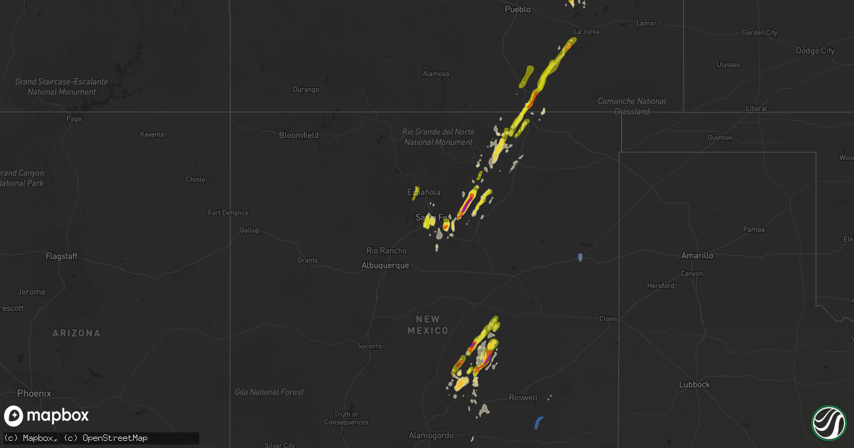
Hail Map on May 22, 2021
Get this storm
May 22 map
$229
one time, instant access
Download today. No call, no setup
Keep the $229
Bought the map and want the full workflow? Apply the entire $229 to a subscription within 7 days. None of it is wasted.
Every map, not just this one
This buys you this map. Subscription and you get every map we run, in the markets you choose from a few cities to whole states to nationwide. Plus real-time alerts the moment a storm fires.
Contact data
Name, contact info, occupancy, even credit band for addresses in the footprint. You go from where it hit to who to call.
Become the source they trust
Unlimited branding weather history reports on demand. You already have the documented answer ready for the property owner, and you are the one who showed up with it.
Property data and RoofTrace estimates
Pull up any address you have got, its value and the exact code rules for that jurisdiction, straight from One Click Code. Then RoofTrace estimates the squares, pitch, and roof value, priced the way you price.
States Impacted by Hail Map on May 22, 2021
Storm reports
Kansas
| Date | Description |
|---|---|
| 05/21/202111:13 PM CDT | At 413 PM CDT, a severe thunderstorm was located 7 miles southwest of Atwood, moving northeast at 30 mph. HAZARD...60 mph wind gusts and quarter size hail. SOURCE...Radar indicated. IMPACT...Hail damage to vehicles is expected. Expect wind damage to roofs, siding, and trees. This severe thunderstorm will be near... Atwood around 430 PM CDT.Other locations in the path of this severe thunderstorm includeLudell.People attending Downtown Atwood should seek safe shelterimmediately! |
| 05/21/20219:31 PM CDT | At 230 PM MDT/330 PM CDT/, a severe thunderstorm was located near Bird City, or 17 miles east of St. Francis, moving northeast at 35 mph. HAZARD...60 mph wind gusts and quarter size hail. SOURCE...Radar indicated. IMPACT...Hail damage to vehicles is expected. Expect wind damage to roofs, siding, and trees. This severe thunderstorm will be near... McDonald around 340 PM CDT. |
Puerto Rico
| Date | Description |
|---|---|
| 05/21/202111:01 PM CDT | At 401 PM AST, a severe thunderstorm was located over Morovis, moving east at 10 mph. HAZARD...60 mph wind gusts and penny size hail. SOURCE...Radar indicated. IMPACT...Expect damage to roofs, siding, and trees. Locations impacted include... Corozal, Morovis, Barahona, Franquez and Miranda. |
New Mexico
| Date | Description |
|---|---|
| 05/22/20216:54 PM CDT | A local report indicates 60 MPH wind near 5 E HAGERMAN |
| 05/22/20216:40 PM CDT | A local report indicates 1.00 inch wind near 2 SSW SANTA FE |
| 05/22/20216:30 PM CDT | A local report indicates 1.25 inch wind near 1 NE CIMARRON |
| 05/22/20215:42 PM CDT | A local report indicates 1.00 inch wind near 2 SW AGUA FRIA |
| 05/22/20215:42 PM CDT | A local report indicates 1.00 inch wind near 2 SW AGUA FRIA |
| 05/22/20215:40 PM CDT | A local report indicates 1.00 inch wind near 2 WSW AGUA FRIA |
| 05/22/20215:40 PM CDT | A local report indicates 1.00 inch wind near 2 SSW SANTA FE |
| 05/22/20215:38 PM CDT | A local report indicates 1.00 inch wind near 6 WSW SANTA FE |
| 05/22/20213:55 PM CDT | A local report indicates 1.50 inch wind near FORT STANTON |
| 05/22/20213:45 PM CDT | A local report indicates 2.00 inch wind near 1 N ROCIADA |
| 05/22/20212:55 PM CDT | A local report indicates 1.50 inch wind near FORT STANTON |
| 05/22/20212:30 PM CDT | Ripped holes through gutters and knocked sections of stucco off the house |
| 05/22/20212:00 PM CDT | A local report indicates 1.50 inch wind near GLORIETA |
| 05/22/20211:24 PM CDT | A local report indicates 1.00 inch wind near 4 SSW SANTA FE |
| 05/22/20211:05 PM CDT | Artist and bishops lodge. |
| 05/22/20217:30 AM CDT | At 1230 PM MDT, a severe thunderstorm was located 8 miles southeast of Galisteo, or 22 miles northeast of Moriarty, moving north at 30 mph. HAZARD...60 mph wind gusts and quarter size hail. SOURCE...Radar indicated. IMPACT...Hail damage to vehicles is expected. Expect wind damage to roofs, siding, and trees. Locations impacted include... Eastern Santa Fe, Eldorado At Santa Fe, Pecos, Canada De Los Alamos, Lamy, Glorieta, Galisteo, Rowe and Upper Colonias.This includes the following highways... Interstate 25 between Mile Markers 284 and 311. Highway 285 between Mile Markers 265 and 290. |
| 05/22/20216:35 AM CDT | At 1135 PM MDT, a severe thunderstorm was located 22 miles northeast of Jicarilla, or 23 miles southeast of Corona, moving northeast at 35 mph. HAZARD...60 mph wind gusts and quarter size hail. SOURCE...Radar indicated. IMPACT...Hail damage to vehicles is expected. Expect wind damage to roofs, siding, and trees. Locations impacted include... Ramon.This includes Highway 285 between Mile Markers 173 and 185. |
| 05/22/20215:45 AM CDT | At 1045 PM MDT, a severe thunderstorm was located near Encinoso, or 20 miles east of Carrizozo, moving northeast at 30 mph. HAZARD...60 mph wind gusts and quarter size hail. SOURCE...Radar indicated. IMPACT...Hail damage to vehicles is expected. Expect wind damage to roofs, siding, and trees. Locations impacted include... Encinoso. |
| 05/22/20211:44 AM CDT | At 644 PM MDT, a severe thunderstorm was located near Starkville, or 7 miles southeast of Trinidad, moving northeast at 40 mph. HAZARD...60 mph wind gusts and quarter size hail. SOURCE...Radar indicated. IMPACT...Hail damage to vehicles is expected. Expect wind damage to roofs, siding, and trees. Locations impacted include... Trinidad, Starkville, Model, Hoehne and Raton Pass. |
| 05/22/20211:24 AM CDT | At 624 PM MDT, a severe thunderstorm was located over Encinoso, or 23 miles east of Carrizozo, moving northeast at 10 mph. HAZARD...60 mph wind gusts and quarter size hail. SOURCE...Radar indicated. IMPACT...Hail damage to vehicles is expected. Expect wind damage to roofs, siding, and trees. Locations impacted include... Encinoso. |
| 05/22/20211:17 AM CDT | At 616 PM MDT, a severe thunderstorm was located near Ramon, or 26 miles southeast of Vaughn, moving northeast at 15 mph. HAZARD...60 mph wind gusts and quarter size hail. SOURCE...Radar indicated. IMPACT...Hail damage to vehicles is expected. Expect wind damage to roofs, siding, and trees. Locations impacted include... Ramon and Yeso. This includes the following highways... Highway 285 between Mile Markers 168 and 199. Highway 60 between Mile Markers 274 and 308, and near Mile Marker310. |
| 05/22/202112:52 AM CDT | At 552 PM MDT, a severe thunderstorm was located 14 miles west of Raton Crews Airport, or 19 miles southwest of Raton, moving northeast at 45 mph. HAZARD...60 mph wind gusts and quarter size hail. SOURCE...Radar indicated. IMPACT...Hail damage to vehicles is expected. Expect wind damage to roofs, siding, and trees. This severe thunderstorm will remain over mainly rural areas of north central Colfax County.This includes the following highways... Interstate 25 between Mile Markers 457 and 460. Highway 64 between Mile Markers 320 and 326. |
| 05/22/202112:38 AM CDT | At 538 PM MDT, severe thunderstorms were located along a line extending from 10 miles southeast of Elkins to Hagerman, moving north at 15 mph. HAZARD...60 mph wind gusts and quarter size hail. SOURCE...Radar indicated. IMPACT...Hail damage to vehicles is expected. Expect wind damage to roofs, siding, and trees. Locations impacted include... Dexter, Hagerman, Lake Arthur, Elkins and Greenfield. This includes the following highways... Highway 285 between Mile Markers 82 and 89. Highway 380 between Mile Markers 168 and 192. |
| 05/22/202112:29 AM CDT | At 529 PM MDT, a severe thunderstorm was located 16 miles southwest of Ramon, or 29 miles southeast of Corona, moving north at 45 mph. HAZARD...60 mph wind gusts and quarter size hail. SOURCE...Radar indicated. IMPACT...Hail damage to vehicles is expected. Expect wind damage to roofs, siding, and trees. Locations impacted include... Vaughn, Ramon and Yeso. This includes the following highways... Highway 285 between Mile Markers 166 and 204. Highway 60 between Mile Markers 266 and 310. |
| 05/22/202112:18 AM CDT | At 518 PM MDT, a severe thunderstorm was located 7 miles southwest of Raton Pass, or 8 miles west of Raton, moving northeast at 35 mph. HAZARD...Ping pong ball size hail and 60 mph wind gusts. SOURCE...Radar indicated. IMPACT...People and animals outdoors will be injured. Expect hail damage to roofs, siding, windows, and vehicles. Expect wind damage to roofs, siding, and trees. Locations impacted include... Trinidad, Cokedale, Starkville, Hoehne and Raton Pass. |
| 05/22/202112:15 AM CDT | At 515 PM MDT, a severe thunderstorm was located near Philmont Scout Ranch, or 21 miles west of Springer, moving northeast at 35 mph. HAZARD...60 mph wind gusts and quarter size hail. SOURCE...Radar indicated. IMPACT...Hail damage to vehicles is expected. Expect wind damage to roofs, siding, and trees. Locations impacted include... Cimarron, Cimarron Canyon State Park, Ute Park, Philmont Scout Ranch and Rayado.This includes Highway 64 between Mile Markers 292 and 330. |
| 05/22/202112:12 AM CDT | At 512 PM MDT, a severe thunderstorm was located 8 miles west of Raton, moving northeast at 35 mph. HAZARD...60 mph wind gusts and quarter size hail. SOURCE...Radar indicated. IMPACT...Hail damage to vehicles is expected. Expect wind damage to roofs, siding, and trees. Locations impacted include... Raton, Sugarite and Sugarite Canyon State Park. This includes the following highways... Interstate 25 between Mile Markers 448 and 460. Highway 64 between Mile Markers 350 and 351. |
| 05/22/202112:02 AM CDT | At 502 PM MDT, a severe thunderstorm was located near Elk, or 25 miles east of Cloudcroft, moving north at 40 mph. HAZARD...60 mph wind gusts and half dollar size hail. SOURCE...Radar indicated. IMPACT...Hail damage to vehicles is expected. Expect wind damage to roofs, siding, and trees. Locations impacted include... Tinnie, Elk, Hondo, Dunken, San Patricio, Sunset and Arabela. This includes Highway 380 between Mile Markers 101 and 107. |
| 05/22/202112:00 AM CDT | At 500 PM MDT, a severe thunderstorm was located 11 miles north of Arabela, or 40 miles northeast of Ruidoso, moving north at 35 mph. HAZARD...60 mph wind gusts and quarter size hail. SOURCE...Radar indicated. IMPACT...Hail damage to vehicles is expected. Expect wind damage to roofs, siding, and trees. Locations impacted include... Arabela. |
| 05/21/202111:57 PM CDT | At 457 PM MDT, a severe thunderstorm was located 8 miles south of Ramon, or 37 miles southeast of Vaughn, moving northeast at 15 mph. HAZARD...60 mph wind gusts and half dollar size hail. SOURCE...Radar indicated. IMPACT...Hail damage to vehicles is expected. Expect wind damage to roofs, siding, and trees. Locations impacted include... Ramon.This includes the following highways... Highway 285 between Mile Markers 160 and 187. Highway 60 between Mile Markers 287 and 292. |
| 05/21/202111:45 PM CDT | At 445 PM MDT, a severe thunderstorm was located near Black Lake, or 21 miles northeast of Mora, moving northeast at 40 mph. HAZARD...60 mph wind gusts and nickel size hail. SOURCE...Radar indicated. IMPACT...Expect damage to roofs, siding, and trees. Locations impacted include... Angel Fire, Ocate, Coyote Creek State Park and Black Lake. This includes Highway 64 near Mile Marker 290. |
| 05/21/202111:38 PM CDT | At 438 PM MDT, a severe thunderstorm was located near Carlsbad Caverns National Park, or 22 miles northeast of Pine Springs, moving northeast at 15 mph. HAZARD...60 mph wind gusts and half dollar size hail. SOURCE...Radar indicated. IMPACT...Hail damage to vehicles is expected. Expect wind damage to roofs, siding, and trees. Locations impacted include... Carlsbad Caverns National Park. |
| 05/21/202111:30 PM CDT | At 429 PM MDT, a severe thunderstorm was located over Cimarron, or 19 miles northwest of Springer, moving northeast at 25 mph. HAZARD...60 mph wind gusts and quarter size hail. SOURCE...Radar indicated. IMPACT...Hail damage to vehicles is expected. Expect wind damage to roofs, siding, and trees. Locations impacted include... Cimarron and Philmont Scout Ranch. This includes Highway 64 between Mile Markers 303 and 330. |
| 05/21/202111:23 PM CDT | At 423 PM MDT, a severe thunderstorm was located over southern Santa Fe, moving north at 55 mph. HAZARD...60 mph wind gusts and quarter size hail. SOURCE...Radar indicated. IMPACT...Hail damage to vehicles is expected. Expect wind damage to roofs, siding, and trees. Locations impacted include... Santa Fe, Espanola, Pojoaque, Eldorado At Santa Fe, Chimayo, Santa Clara Pueblo, Cuartelez, Rio Chiquito, Embudo and Penasco.This includes the following highways... Interstate 25 between Mile Markers 273 and 291. Highway 285 between Mile Markers 286 and 290, and between MileMarkers 338 and 363. |
| 05/21/202111:22 PM CDT | At 421 PM MDT, a severe thunderstorm was located 5 miles north of Pinon, moving northeast at 10 mph. HAZARD...Ping pong ball size hail and 60 mph wind gusts. SOURCE...Radar indicated. IMPACT...People and animals outdoors will be injured. Expect hail damage to roofs, siding, windows, and vehicles. Expect wind damage to roofs, siding, and trees. Locations impacted include... Pinon. |
| 05/21/202111:16 PM CDT | At 414 PM MDT, a severe thunderstorm was located near Tinnie, or 23 miles east of Ruidoso, moving northeast at 40 mph. HAZARD...60 mph wind gusts and quarter size hail. SOURCE...Radar indicated. IMPACT...Hail damage to vehicles is expected. Expect wind damage to roofs, siding, and trees. Locations impacted include... Hondo, Arabela, Tinnie, San Patricio and Sunset. This includes Highway 380 between Mile Markers 99 and 107. |
| 05/21/202111:14 PM CDT | At 412 PM MDT, a severe thunderstorm was located 15 miles south of Hope, moving north at 10 mph. HAZARD...60 mph wind gusts and half dollar size hail. SOURCE...Radar indicated. IMPACT...Hail damage to vehicles is expected. Expect wind damage to roofs, siding, and trees. This severe thunderstorm will remain over mainly rural areas of west central Eddy County. |
| 05/21/202111:02 PM CDT | At 402 PM MDT, a severe thunderstorm was located over Mora, moving north at 40 mph. HAZARD...60 mph wind gusts and quarter size hail. SOURCE...Radar indicated. IMPACT...Hail damage to vehicles is expected. Expect wind damage to roofs, siding, and trees. Locations impacted include... Mora, Angel Fire, La Cueva, Ledoux, Sapello, Cleveland, Black Lake, Tierra Monte, Ocate and Coyote Creek State Park.This includes Highway 64 between Mile Markers 269 and 270. |
| 05/21/202110:46 PM CDT | At 346 PM MDT, a severe thunderstorm was located 7 miles north of Ocate, or 24 miles west of Springer, moving northeast at 35 mph. HAZARD...60 mph wind gusts and quarter size hail. SOURCE...Radar indicated. IMPACT...Hail damage to vehicles is expected. Expect wind damage to roofs, siding, and trees. Locations impacted include... Cimarron, Philmont Scout Ranch, Rayado and Miami. This includes the following highways... Interstate 25 between Mile Markers 415 and 417. Highway 64 between Mile Markers 306 and 316. |
| 05/21/202110:44 PM CDT | At 344 PM MDT, a severe thunderstorm was located near Canon Plaza, or 23 miles east of Tierra Amarilla, moving north at 55 mph. HAZARD...60 mph wind gusts and quarter size hail. SOURCE...Radar indicated. IMPACT...Hail damage to vehicles is expected. Expect wind damage to roofs, siding, and trees. Locations impacted include... Canon Plaza, Vallecitos, Petaca, Tres Piedras, Los Pinos and Las Tablas.This includes the following highways... Highway 285 between Mile Markers 382 and 408. Highway 64 between Mile Markers 202 and 223. |
| 05/21/202110:34 PM CDT | At 334 PM MDT, a severe thunderstorm was located near White Rock, or near Los Alamos, moving north at 20 mph. HAZARD...60 mph wind gusts and half dollar size hail. SOURCE...Radar indicated. IMPACT...Hail damage to vehicles is expected. Expect wind damage to roofs, siding, and trees. Locations impacted include... Los Alamos, Espanola, White Rock, Santa Clara Pueblo, Embudo, Abiquiu, Santa Cruz, Velarde, Chili and Alcalde.This includes Highway 285 between Mile Markers 337 and 350. |
| 05/21/202110:28 PM CDT | At 328 PM MDT, a severe thunderstorm was located 17 miles north of Arabela, or 39 miles southeast of Corona, moving northeast at 20 mph. HAZARD...60 mph wind gusts and quarter size hail. SOURCE...Radar indicated. IMPACT...Hail damage to vehicles is expected. Expect wind damage to roofs, siding, and trees. This severe thunderstorm will remain over mainly rural areas of east central Lincoln and northwestern Chaves Counties. |
| 05/21/202110:23 PM CDT | At 323 PM MDT, a severe thunderstorm was located 15 miles southeast of Tinnie, or 32 miles northwest of Hope, moving northeast at 20 mph. HAZARD...60 mph wind gusts and quarter size hail. SOURCE...Radar indicated. IMPACT...Hail damage to vehicles is expected. Expect wind damage to roofs, siding, and trees. Locations impacted include... Southern Roswell and Sunset. |
| 05/21/202110:21 PM CDT | At 320 PM MDT, a severe thunderstorm was located 15 miles north of Lincoln National Forest, or 19 miles south of Hope, moving northeast at 15 mph. HAZARD...60 mph wind gusts and quarter size hail. SOURCE...Radar indicated. IMPACT...Hail damage to vehicles is expected. Expect wind damage to roofs, siding, and trees. Locations impacted include... Hope. |
| 05/21/202110:11 PM CDT | At 309 PM MDT, a severe thunderstorm was located 12 miles south of Timberon, moving northeast at 20 mph. HAZARD...60 mph wind gusts and half dollar size hail. SOURCE...Radar indicated. IMPACT...Hail damage to vehicles is expected. Expect wind damage to roofs, siding, and trees. Locations impacted include... Timberon. |
| 05/21/20219:56 PM CDT | At 256 PM MDT, a severe thunderstorm was located 18 miles north of Dell City, moving northeast at 15 mph. HAZARD...Two inch hail and 60 mph wind gusts. SOURCE...Radar indicated. IMPACT...People and animals outdoors will be injured. Expect hail damage to roofs, siding, windows, and vehicles. Expect wind damage to roofs, siding, and trees. Locations impacted include... Crow Flats. |
| 05/21/20219:45 PM CDT | At 245 PM MDT, a severe thunderstorm was located over Tierra Monte, or near Mora, moving northeast at 35 mph. HAZARD...60 mph wind gusts and quarter size hail. SOURCE...Radar indicated. IMPACT...Hail damage to vehicles is expected. Expect wind damage to roofs, siding, and trees. Locations impacted include... Mora, Angel Fire, La Cueva, Ledoux, Cleveland, Black Lake, Tierra Monte, Ocate, Coyote Creek State Park and Morphy Lake State Park.This includes Highway 64 between Mile Markers 263 and 268. |
| 05/21/20219:40 PM CDT | Ktcc asos. |
| 05/21/20219:25 PM CDT | At 224 PM MDT, a severe thunderstorm was located near Encinoso, or 23 miles northeast of Ruidoso, moving northeast at 20 mph. HAZARD...Ping pong ball size hail and 60 mph wind gusts. SOURCE...Radar indicated. IMPACT...People and animals outdoors will be injured. Expect hail damage to roofs, siding, windows, and vehicles. Expect wind damage to roofs, siding, and trees. Locations impacted include... Lincoln, Lincoln State Monument and Arabela. This includes Highway 380 between Mile Markers 92 and 98. |
| 05/21/20219:02 PM CDT | A local report indicates 68 MPH wind near 7 N NEWKIRK |
| 05/21/20218:54 PM CDT | At 154 PM MDT, a severe thunderstorm was located near Upper Colonias, or 20 miles west of Las Vegas, moving north at 30 mph. HAZARD...60 mph wind gusts and quarter size hail. SOURCE...Radar indicated. IMPACT...Hail damage to vehicles is expected. Expect wind damage to roofs, siding, and trees. Locations impacted include... Pecos, La Cueva, Cowles, Ledoux, Tererro, Upper Colonias, Tierra Monte, El Porvenir, Morphy Lake State Park and Gascon.This includes Interstate 25 between Mile Markers 301 and 305. |
| 05/21/20218:41 PM CDT | At 140 PM MDT, a severe thunderstorm was located over Fort Stanton, or 14 miles northeast of Ruidoso, moving north at 40 mph. HAZARD...60 mph wind gusts and half dollar size hail. SOURCE...Radar indicated. IMPACT...Hail damage to vehicles is expected. Expect wind damage to roofs, siding, and trees. Locations impacted include... Ruidoso, Capitan, Encinoso, Jicarilla, Ancho, Fort Stanton, Smokey Bear Historical Park and Angus.This includes Highway 380 between Mile Markers 77 and 95. |
| 05/21/20218:09 PM CDT | At 109 PM MDT, a severe thunderstorm was located 10 miles northeast of Stanley, or 20 miles northeast of Moriarty, moving north at 40 mph. HAZARD...60 mph wind gusts and quarter size hail. SOURCE...Radar indicated. IMPACT...Hail damage to vehicles is expected. Expect wind damage to roofs, siding, and trees. Locations impacted include... Eldorado At Santa Fe, Pecos, Canada De Los Alamos, Upper Colonias, Lamy, Glorieta, Rowe, South San Ysidro, North San Ysidro and Lower Colonias.This includes the following highways... Interstate 25 between Mile Markers 290 and 316. Highway 285 between Mile Markers 259 and 283, and between MileMarkers 288 and 290. |
| 05/21/20217:21 PM CDT | Krow asos. |
Texas
| Date | Description |
|---|---|
| 05/22/20212:16 PM CDT | A local report indicates 66 MPH wind near 11 WNW BOOTLEG |
| 05/22/20213:49 AM CDT | At 849 PM MDT, severe thunderstorms were located along a line extending from 9 miles north of Tucumcari to 7 miles southeast of San Jon, moving north at 30 mph. HAZARD...70 mph wind gusts. SOURCE...Radar indicated. IMPACT...Expect considerable tree damage. Damage is likely to mobile homes, roofs, and outbuildings. Locations impacted include... Logan, San Jon, Ute Lake State Park and Bard. This includes Interstate 40 between Mile Markers 340 and 372. |
| 05/21/202111:16 PM CDT | At 416 PM MDT, a severe thunderstorm was located 12 miles northeast of Dell City, moving northeast at 30 mph. HAZARD...Ping pong ball size hail and 60 mph wind gusts. SOURCE...Radar indicated. IMPACT...People and animals outdoors will be injured. Expect hail damage to roofs, siding, windows, and vehicles. Expect wind damage to roofs, siding, and trees. Locations impacted include... Lincoln National Forest, Crow Flats and Brokeoff Mountains. |
| 05/21/20219:32 PM CDT | At 229 PM MDT, a severe thunderstorm was located 13 miles south of Cornudas, moving northeast at 25 mph. The storm will be moving through Farm Road 1111 and towards highway 62 & 180 between Cornudas and Slat Flat. HAZARD...60 mph wind gusts and quarter size hail. SOURCE...Radar indicated. IMPACT...Hail damage to vehicles is expected. Expect wind damage to roofs, siding, and trees. This severe thunderstorm will remain over mainly rural areas of northeastern Hudspeth County. |
Colorado
| Date | Description |
|---|---|
| 05/22/20216:44 PM CDT | Asos station kril garfield county rgnl ap. |
| 05/22/20215:30 PM CDT | A local report indicates a tornado near 10 N PUNKIN CENTER |
| 05/22/20215:28 PM CDT | A local report indicates a tornado near 10 N PUNKIN CENTER |
| 05/22/20215:05 PM CDT | A local report indicates a tornado near 4 SW PUNKIN CENTER |
| 05/22/20215:00 PM CDT | A local report indicates a tornado near 4 N FORDER |
| 05/22/20214:56 PM CDT | A local report indicates a tornado near 1 WNW FORDER |
| 05/22/20214:23 PM CDT | Report from mping: quarter |
| 05/22/20214:14 PM CDT | Corrects previous non-tstm wnd gst report from 4 e mancos. Mesonet station co134 160e061 mancos. |
| 05/22/20213:45 PM CDT | Very brief touchdown. No damage. |
| 05/22/20213:33 PM CDT | A local report indicates 1.25 inch wind near 10 N ORDWAY |
| 05/22/20213:12 PM CDT | A local report indicates 1.00 inch wind near 4 WNW AKRON |
| 05/22/20213:08 PM CDT | A local report indicates a tornado near 2 S BENNETT |
| 05/22/20213:04 PM CDT | 0.375 inch depth on ground... Pea to quarter sized. |
| 05/22/20213:03 PM CDT | Brief... Weak tornado. Has dissipated. |
| 05/22/20212:58 PM CDT | M149... Chasing. |
| 05/22/20212:47 PM CDT | Brief ground circulation. |
| 05/22/20212:30 PM CDT | A local report indicates a tornado near 5 ENE ADENA SCHOOL |
| 05/22/20214:37 AM CDT | At 935 PM MDT, a severe thunderstorm was located 5 miles north of Boyero, or 22 miles southwest of Flagler, moving north at 45 mph. HAZARD...60 mph wind gusts and quarter size hail. SOURCE...Radar indicated. IMPACT...Expect damage to roofs, siding, and trees. Hail damage to vehicles is expected. Locations impacted include... Arriba and Boyero. |
| 05/22/20213:28 AM CDT | At 828 PM MDT, a severe thunderstorm was located over Timpas, or 16 miles southwest of La Junta, moving northeast at 40 mph. HAZARD...60 mph wind gusts and half dollar size hail. SOURCE...Radar indicated. IMPACT...Hail damage to vehicles is expected. Expect wind damage to roofs, siding, and trees. Locations impacted include... La Junta, North La Junta, Rocky Ford, Swink, Cheraw and Timpas. |
| 05/22/20213:02 AM CDT | At 802 PM MDT, a severe thunderstorm was located near Delhi, or 32 miles southwest of La Junta, moving northeast at 45 mph. HAZARD...60 mph wind gusts and half dollar size hail. SOURCE...Radar indicated. IMPACT...Hail damage to vehicles is expected. Expect wind damage to roofs, siding, and trees. Locations impacted include... Delhi, Timpas and Thatcher. |
| 05/22/20212:49 AM CDT | At 749 PM MDT, a severe thunderstorm was located over Thatcher, or 35 miles northeast of Trinidad, moving northeast at 55 mph. HAZARD...60 mph wind gusts and half dollar size hail. SOURCE...Radar indicated. IMPACT...Hail damage to vehicles is expected. Expect wind damage to roofs, siding, and trees. Locations impacted include... Delhi, Timpas and Thatcher. |
| 05/22/20211:27 AM CDT | At 627 PM MDT, a severe thunderstorm was located near Tyrone, or 24 miles northeast of Trinidad, moving northeast at 40 mph. HAZARD...60 mph wind gusts and half dollar size hail. SOURCE...Radar indicated. IMPACT...Hail damage to vehicles is expected. Expect wind damage to roofs, siding, and trees. Locations impacted include... Model, Delhi, Timpas, Thatcher and Tyrone. |
| 05/22/202112:51 AM CDT | At 551 PM MDT, a severe thunderstorm was located near Trinidad, moving northeast at 35 mph. HAZARD...Golf ball size hail and 60 mph wind gusts. SOURCE...Radar indicated. IMPACT...People and animals outdoors will be injured. Expect hail damage to roofs, siding, windows, and vehicles. Expect wind damage to roofs, siding, and trees. Locations impacted include... Trinidad, Model, Hoehne and Tyrone. |
| 05/22/202112:27 AM CDT | At 526 PM MDT, severe thunderstorms were located along a line extending from 8 miles northeast of Kutch to 14 miles southwest of Forder, or along a line extending from 19 miles south of Limon to 42 miles northeast of Pueblo, moving north at 45 mph. HAZARD...60 mph wind gusts and penny size hail. SOURCE...Radar indicated. IMPACT...Expect damage to roofs, siding, and trees. Locations impacted include... Forder, Kutch and Punkin Center. |
| 05/21/202111:10 PM CDT | At 410 PM MDT, a severe thunderstorm was located 15 miles northwest of Tyrone, or 31 miles north of Trinidad, moving northeast at 35 mph. HAZARD...60 mph wind gusts and half dollar size hail. SOURCE...Radar indicated. IMPACT...Hail damage to vehicles is expected. Expect wind damage to roofs, siding, and trees. This severe thunderstorm will remain over mainly rural areas of southwestern Otero, east central Huerfano, north central Las Animas and southeastern Pueblo Counties. |
| 05/21/202110:53 PM CDT | At 353 PM MDT, a severe thunderstorm was located 4 miles west of Riverside Reservoir, or 22 miles east of Greeley, moving north at 35 mph. HAZARD...Quarter size hail. SOURCE...Radar indicated. IMPACT...Damage to vehicles is expected. Locations impacted include... Wiggins, Orchard, Weldona, Jackson Reservoir, Riverside Reservoir, Briggsdale, Goodrich and Roggen. |
| 05/21/202110:33 PM CDT | At 333 PM MDT, a severe thunderstorm was located 10 miles south of Truckton, or 33 miles northeast of Pueblo, moving north at 35 mph. HAZARD...Ping pong ball size hail and 60 mph wind gusts. SOURCE...Radar indicated. IMPACT...People and animals outdoors will be injured. Expect hail damage to roofs, siding, windows, and vehicles. Expect wind damage to roofs, siding, and trees. Locations impacted include... Truckton and Rush. |
| 05/21/202110:29 PM CDT | At 329 PM MDT, a severe thunderstorm was located 7 miles northeast of Boncarbo, or 8 miles northwest of Trinidad, moving northeast at 45 mph. HAZARD...60 mph wind gusts and quarter size hail. SOURCE...Radar indicated. IMPACT...Hail damage to vehicles is expected. Expect wind damage to roofs, siding, and trees. Locations impacted include... Trinidad, Aguilar, Model, Hoehne and Tyrone. |
| 05/21/202110:25 PM CDT | At 325 PM MDT, a severe thunderstorm was located near Prospect Valley, or 30 miles southeast of Greeley, moving northeast at 20 mph. HAZARD...Quarter size hail. SOURCE...Radar indicated. IMPACT...Damage to vehicles is expected. Locations impacted include... Prospect Valley and Roggen. |
| 05/21/202110:09 PM CDT | At 307 PM MDT, a severe thunderstorm was located near Julesburg, moving north at 30 mph. HAZARD...Golf ball size hail and 60 mph wind gusts. SOURCE...Radar indicated. IMPACT...People and animals outdoors will be injured. Expect hail damage to roofs, siding, windows, and vehicles. Expect wind damage to roofs, siding, and trees. Locations impacted include... Chappell, Big Springs, Barton, Goldeneye State Wildlife Management Area and Megeath.This includes Interstate 80 in Nebraska between mile markers 86 and113. |
| 05/21/202110:07 PM CDT | At 307 PM MDT, a severe thunderstorm was located 7 miles south of Truckton, or 33 miles northeast of Pueblo, moving north at 35 mph. HAZARD...Ping pong ball size hail and 60 mph wind gusts. SOURCE...Radar indicated. IMPACT...People and animals outdoors will be injured. Expect hail damage to roofs, siding, windows, and vehicles. Expect wind damage to roofs, siding, and trees. Locations impacted include... Truckton, Yoder and Rush. |
| 05/21/202110:03 PM CDT | At 303 PM MDT, a severe thunderstorm was located near Segundo, or 16 miles southwest of Trinidad, moving northeast at 50 mph. HAZARD...60 mph wind gusts and quarter size hail. SOURCE...Radar indicated. IMPACT...Hail damage to vehicles is expected. Expect wind damage to roofs, siding, and trees. Locations impacted include... Trinidad, Aguilar, Cokedale, Gulnare, Boncarbo, Segundo and Weston. |
| 05/21/20219:57 PM CDT | At 256 PM MDT, a severe thunderstorm was located 6 miles southwest of Fleming, or 12 miles east of Sterling, moving northeast at 35 mph. HAZARD...Quarter size hail. SOURCE...Radar indicated. IMPACT...Damage to vehicles is expected. Locations impacted include... Fleming, Iliff, Crook, St Petersburg, Proctor and Twin Buttes. |
| 05/21/20219:46 PM CDT | At 246 PM MDT, a severe thunderstorm was located near Sixteen-Mile Corner, or 13 miles north of Holyoke, moving north at 35 mph. HAZARD...Quarter size hail. SOURCE...Radar indicated. IMPACT...Damage to vehicles is expected. Locations impacted include... Julesburg, Ovid and Sixteen-Mile Corner. |
| 05/21/20219:31 PM CDT | At 231 PM MDT, a severe thunderstorm was located 11 miles north of Ordway, or 30 miles northwest of La Junta, moving north at 35 mph. HAZARD...60 mph wind gusts and half dollar size hail. SOURCE...Radar indicated. IMPACT...Hail damage to vehicles is expected. Expect wind damage to roofs, siding, and trees. This severe thunderstorm will remain over mainly rural areas of northeastern Crowley County. |
| 05/21/20218:58 PM CDT | At 158 PM MDT, a severe thunderstorm was located near Midway, or 14 miles northwest of Akron, moving northeast at 40 mph. HAZARD...60 mph wind gusts and quarter size hail. SOURCE...Radar indicated. IMPACT...Expect damage to roofs, siding, and trees. Hail damage to vehicles is expected. Locations impacted include... Sterling, Akron, Brush, Otis, Merino, Hillrose, Prewitt Reservoir, Atwood, Platner, Willard, Burdett, Logan Corners, Snyder, Midway and Pawnee Pass. |
| 05/21/20218:56 PM CDT | At 156 PM MDT, a severe thunderstorm was located 4 miles south of Franktown, or 30 miles south of Denver, moving north at 25 mph. HAZARD...60 mph wind gusts and half dollar size hail. SOURCE...Radar indicated. IMPACT...Expect damage to roofs, siding, and trees. Hail damage to vehicles is expected. Locations impacted include... Castle Rock, Parker, Elizabeth, Ponderosa Park, The Pinery, Franktown and eastern Castle Pines. |
| 05/21/20218:11 PM CDT | At 111 PM MDT, a severe thunderstorm was located near Woodrow, or 18 miles southeast of Fort Morgan, moving north at 45 mph. HAZARD...60 mph wind gusts and quarter size hail. SOURCE...Radar indicated. IMPACT...Expect damage to roofs, siding, and trees. Hail damage to vehicles is expected. Locations impacted include... Fort Morgan, Brush, Log Lane Village, Merino, Hillrose, Gary, Prewitt Reservoir, Antelope Springs, Twelve-Mile Corner, Adena School, Woodlin School, Snyder, Midway and Woodrow. |
| 05/21/20218:08 PM CDT | At 108 PM MDT, a severe thunderstorm was located over northwestern Colorado Springs, moving north at 25 mph. HAZARD...60 mph wind gusts and half dollar size hail. SOURCE...Radar indicated. IMPACT...Hail damage to vehicles is expected. Expect wind damage to roofs, siding, and trees. Locations impacted include... Colorado Springs, Monument, Air Force Academy, Manitou Springs, Palmer Lake, Black Forest, Falcon, Stratmoor, Gleneagle, Peterson AFB, Cimarron Hills, Security, Security-Widefield and Fort Carson. |
| 05/21/20217:37 PM CDT | A local report indicates 1.00 inch wind near 12 S TRINIDAD |
Cities Impacted by Hail Map on May 22, 2021
- Akron, CO
- Brush, CO
- Ocate, NM
- Keenesburg, CO
- Capitan, NM
- Artesia, NM
- Lake Arthur, NM
- Ordway, CO
- Glorieta, NM
- Pecos, NM
- Ribera, NM
- Tererro, NM
- Strasburg, CO
- Trinchera, CO
- Rociada, NM
- Mora, NM
- Roggen, CO
- Raton, NM
- Nogal, NM
- Corona, NM
- Rocky Ford, CO
- Franktown, CO
- Parker, CO
- Castle Rock, CO
- Julesburg, CO
- Bennett, CO
- Lincoln, NM
- San Patricio, NM
- Glencoe, NM
- Las Vegas, NM
- Woodrow, CO
- Santa Fe, NM
- Larkspur, CO
- Montezuma, NM
- Buena Vista, NM
- Sapello, NM
- Sugar City, CO
- Stanley, NM
- Matheson, CO
- Hudson, CO
- Trinidad, CO
- Cimarron, NM
- Ruidoso, NM
- Alto, NM
- McDonald, KS
- Atwood, KS
- Model, CO
- Cleveland, NM
- Tinnie, NM
- Kersey, CO
- Fleming, CO
- San Jose, NM
- Denver, CO
- Maxwell, NE
- North Platte, NE
- Springer, NM
- Lamy, NM
- Bird City, KS
- Colorado Springs, CO
- Yoder, CO
- Maxwell, NM
- Ovid, CO
- Mescalero, NM
- Hondo, NM
- Sterling, CO
- Wagon Mound, NM
- Hagerman, NM
- Tucumcari, NM
- Limon, CO
- Haxtun, CO
- Crook, CO
- Holyoke, CO
- Briggsdale, CO
- Rush, CO
- Hugo, CO
- Ramah, CO
- Karval, CO
- Espanola, NM
- Vaughn, NM