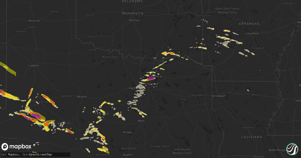
Hail Map on May 19, 2023
Get this storm
May 19 map
$229
one time, instant access
Download today. No call, no setup
Keep the $229
Bought the map and want the full workflow? Apply the entire $229 to a subscription within 7 days. None of it is wasted.
Every map, not just this one
This buys you this map. Subscription and you get every map we run, in the markets you choose from a few cities to whole states to nationwide. Plus real-time alerts the moment a storm fires.
Contact data
Name, contact info, occupancy, even credit band for addresses in the footprint. You go from where it hit to who to call.
Become the source they trust
Unlimited branding weather history reports on demand. You already have the documented answer ready for the property owner, and you are the one who showed up with it.
Property data and RoofTrace estimates
Pull up any address you have got, its value and the exact code rules for that jurisdiction, straight from One Click Code. Then RoofTrace estimates the squares, pitch, and roof value, priced the way you price.
States Impacted by Hail Map on May 19, 2023
Storm reports
Texas
| Date | Description |
|---|---|
| 05/19/20236:57 PM CDT | Ham reports 1.5 inch hail measured; near exchange parkway and us-75. Time estimated by radar. |
| 05/19/20236:57 PM CDT | Delayed report - golf ball sized hail in allen; caused damage to window and car. Time estimated by radar. |
| 05/19/20236:57 PM CDT | Corrects previous hail report from 1 ene allen. Ham reports 2.5 inch measured hail stone near greenville and exchange parkway in allen. Time estimated by radar. |
| 05/19/20236:57 PM CDT | Corrects previous hail report from 1 n allen. Ham reports 1.5 inch hail measured; near exchange parkway and us-75. Time estimated by radar. |
| 05/19/20236:52 PM CDT | Report from mping: golf ball |
| 05/19/20236:52 PM CDT | Ham reports 2 inch hail near greenville and bethany in allen. Time estimated by radar. |
| 05/19/20236:50 PM CDT | Estimated inflow winds |
| 05/19/20236:50 PM CDT | A local report indicates 1.00 inch wind near 2 SSE CHEROKEE |
| 05/19/20236:50 PM CDT | Nws employee reported 1.75 inch hail in plano. |
| 05/19/20236:48 PM CDT | Ham reported 2 inch hail near mcdermott and independence in plano. Time estimated by radar. |
| 05/19/20236:45 PM CDT | Delayed report - 2 inch hail reported at 3865 preston rd in south frisco by trained spotter. |
| 05/19/20236:44 PM CDT | Trained spotter reports ping pong sized hail at corner of legacy dr and ohio dr in plano. Time estimated by radar. |
| 05/19/20236:43 PM CDT | Em reports quarter sized hail at the ford center in frisco. Time estimated by radar. |
| 05/19/20236:43 PM CDT | A local report indicates 1.00 inch wind near 4 SSE CHEROKEE |
| 05/19/20236:34 PM CDT | A local report indicates 1.00 inch wind near 9 SSE SPRABERRY |
| 05/19/20236:02 PM CDT | Half dollar |
| 05/19/20235:57 PM CDT | A local report indicates 1.00 inch wind near 1 S ZEPHYR |
| 05/19/20235:41 PM CDT | A local report indicates 1.75 inch wind near 4 SSE WEST ODESSA |
| 05/19/20235:40 PM CDT | A local report indicates 1.00 inch wind near 3 NW MIDLAND |
| 05/19/20235:40 PM CDT | A local report indicates 1.25 inch wind near ROCHELLE |
| 05/19/20235:36 PM CDT | Report from mping: quarter |
| 05/19/20235:35 PM CDT | A local report indicates 1.75 inch wind near 5 WNW MIDLAND |
| 05/19/20235:24 PM CDT | Quarter to half dollar hail on us -190 east of rochelle. |
| 05/19/20234:48 PM CDT | Report from mping: half dollar |
| 05/19/20234:31 PM CDT | Multiple power line poles down near fm 903 and highway 380. Time estimated by radar. |
| 05/19/20234:27 PM CDT | Powerlines and power poles snapped; some mature trees uprooted or snapped; hay barn roof destroyed; damage swath round 1/10 of a mile. Time estimated by radar. |
| 05/19/20233:46 PM CDT | Social media report of quarter sized hail in north richland hills. Time estimated by radar. |
| 05/19/20233:05 PM CDT | Ham reports 1 inch hail 1 mile n of us-380 and dallas tollway. Time estimated by radar. |
| 05/19/20233:01 PM CDT | Em reports dime to quarter sized hail in flower mound. Time estimated by radar. |
| 05/19/20232:36 PM CDT | Ham reports quarter-sized hail falling near fm 1553 and highway 11. |
| 05/19/20231:10 AM CDT | A local report indicates 59 MPH wind near MIDLAND INTERNATIONAL |
| 05/18/202310:59 PM CDT | Delayed report - large tree across road. Time estimated by radar. |
| 05/18/202310:55 PM CDT | Delayed report - tree across road. Time estimated by radar. |
| 05/18/202310:55 PM CDT | Delayed report - tree across road. Time estimated by radar. |
| 05/18/202310:26 PM CDT | Delayed report - tree across road and on a car. Time estimated by radar. |
| 05/18/202310:25 PM CDT | Delayed report - tree across road and on a car. Time estimated by radar. |
| 05/18/202310:22 PM CDT | Delayed report - power lines down near the leon river bridge; eventually there was a loss of power on west side of gatesville. Time estimated by radar. |
| 05/18/20239:30 PM CDT | Estimated 60 mph gust snapped 2 inch in diameter tree branch. |
| 05/18/20239:28 PM CDT | Small tree branches were blown down in downtown san angelo. |
| 05/18/20239:25 PM CDT | Large tree snapped near the base in highland range. |
| 05/18/20239:00 PM CDT | Large tree branches 3-4 inches in diameter broken by the wind. |
| 05/18/20238:45 PM CDT | A local report indicates 1.50 inch wind near 6 NNE TANKERSLEY |
| 05/18/20238:38 PM CDT | A local report indicates 1.00 inch wind near 4 WSW SAN ANGELO |
| 05/18/20238:09 PM CDT | A local report indicates 62 MPH wind near 1 S LAMESA |
| 05/18/20238:05 PM CDT | A local report indicates 1.00 inch wind near 2 SE BROWNWOOD |
| 05/18/20237:40 PM CDT | A local report indicates 1.00 inch wind near 3 S BROWNWOOD |
| 05/18/20237:36 PM CDT | Public report of snapped power poles along fm 846 east of vealmoor. Location is estimated by radar. |
| 05/18/20237:17 PM CDT | Report from mping: golf ball |
| 05/18/20237:14 PM CDT | A local report indicates 1.00 inch wind near 3 N BRADY |
| 05/18/20237:08 PM CDT | A local report indicates 2.00 inch wind near VALLEY SPRING |
| 05/18/20237:05 PM CDT | Ham reports 2 inch hail measured at country club rd and west lucas rd in lucas. Time estimated by radar. |
| 05/18/20237:00 PM CDT | Ham reports 2.5 inch measured hail stone near greenville and exchange parkway in allen. Time estimated by radar. |
Arkansas
| Date | Description |
|---|---|
| 05/19/20236:55 PM CDT | Tree down over road. |
| 05/19/20236:50 PM CDT | Several trees down in dayton area. |
| 05/19/20236:46 PM CDT | Tree down in pearcy. |
| 05/19/20236:32 PM CDT | Trees reported down in pencil bluff. |
| 05/19/20236:25 PM CDT | Trees down on brushy creek road. |
| 05/18/20238:30 PM CDT | Large tree down in the piney... Ar area. |
Oregon
| Date | Description |
|---|---|
| 05/19/20236:30 PM CDT | Social media report. Time estimated from radar. |
| 05/18/20238:48 PM CDT | Mesonet station npfo3 north pole ridge. |
| 05/18/20237:45 PM CDT | Mesonet station mdxo moody farms control station. |
New Mexico
| Date | Description |
|---|---|
| 05/19/20236:17 PM CDT | A local report indicates 1.75 inch wind near 4 W LAKE ARTHUR |
| 05/19/20236:00 PM CDT | A local report indicates 62 MPH wind near 4 W LAKE ARTHUR |
| 05/18/20238:23 PM CDT | A local report indicates 1.00 inch wind near 12 S BUCKEYE |
Oklahoma
| Date | Description |
|---|---|
| 05/19/20235:30 PM CDT | Media relayed twitter photo. |
| 05/19/20232:00 PM CDT | A local report indicates 1.75 inch wind near 1 S UNGER |
| 05/19/20231:43 PM CDT | A local report indicates 1.75 inch wind near BOSWELL |
Florida
| Date | Description |
|---|---|
| 05/19/20233:36 PM CDT | Pbsco received two calls at 4:36pm of a power line down at the intersection of south rambling drive and south rambling drive circle. This occurred as a severe thunderst |
| 05/19/20232:36 PM CDT | Corrects previous tstm wnd dmg report from 1 e wellington. Pbsco received two calls at 3:36pm of a power line down at the intersection of south rambling drive and south |
Cities Impacted by Hail Map on May 19, 2023
- Boswell, OK
- Bennington, OK
- Colbert, OK
- Hugo, OK
- Soper, OK
- Celina, TX
- Trenton, TX
- Randolph, TX
- Bonham, TX
- Leonard, TX
- Grant, OK
- Wolfe City, TX
- Bailey, TX
- Whitewright, TX
- Sherman, TX
- Tom Bean, TX
- Savoy, TX
- Ector, TX
- Aubrey, TX
- Prosper, TX
- Flower Mound, TX
- Lewisville, TX
- Yeso, NM
- Fort Sumner, NM
- Carrollton, TX
- The Colony, TX
- Haltom City, TX
- North Richland Hills, TX
- Fort Worth, TX
- Hurst, TX
- Bagwell, TX
- Roswell, NM
- Taiban, NM
- Rochelle, TX
- Brookesmith, TX
- Brownwood, TX
- Waldron, AR
- Odessa, TX
- Pottsboro, TX
- Saint Jo, TX
- Whitesboro, TX
- Sadler, TX
- Forestburg, TX
- Anson, TX
- Throckmorton, TX
- Coahoma, TX
- Loving, TX
- Newcastle, TX
- Sunset, TX
- Jacksboro, TX
- Graham, TX
- Sweetwater, TX
- Cartwright, OK
- Garden City, TX
- Bowie, TX
- Bryson, TX
- Westbrook, TX
- Big Spring, TX
- Colorado City, TX
- Denison, TX
- Roscoe, TX
- Calera, OK
- Lueders, TX
- Durant, OK
- Sylvester, TX
- Stanton, TX
- Jermyn, TX
- Midland, TX
- Woodson, TX
- Loraine, TX
- Gainesville, TX
- Muenster, TX
- Bokchito, OK
- Whitney, TX
- Richland Springs, TX
- Plano, TX
- Frisco, TX
- Midkiff, TX
- Hamilton, TX
- Zephyr, TX
- Pep, NM
- Milnesand, NM
- Tatum, NM
- San Saba, TX
- Cherokee, TX
- Valley Spring, TX
- San Angelo, TX
- Eldorado, TX
- Vancourt, TX
- Allen, TX
- Mckinney, TX
- Tarzan, TX
- Llano, TX
- Mayhill, NM
- Lake Arthur, NM
- Hagerman, NM
- Artesia, NM
- Big Lake, TX
- Morton, TX
- Whiteface, TX
- Plains, TX
- Brady, TX
- Lamesa, TX
- Princeton, TX
- Barnhart, TX
- Dallas, TX
- Aquilla, TX
- Abbott, TX
- West, TX
- Mentone, TX
- Mertzon, TX
- Menard, TX
- Bluff Dale, TX
- Stephenville, TX
- Gorman, TX
- De Leon, TX
- Desdemona, TX
- Lovington, NM
- Early, TX
- Ackerly, TX
- Sterling City, TX
- Fredericksburg, TX
- Willow City, TX
- Jal, NM
- Hobbs, NM
- May, TX
- Monument, NM
- Rising Star, TX
- Comanche, TX
- Blanket, TX
- Eunice, NM
- Carbon, TX
- Seminole, TX
- Andrews, TX
- Mason, TX
- Johnson City, TX
- Melvin, TX
- San Antonio, TX
- Fossil, OR
- Condon, OR
- Plainview, AR
- Jonesboro, TX
- Loving, NM
- Grannis, AR
- Gillham, AR
- Redmond, OR
- Culver, OR
- Terrebonne, OR
- Madras, OR
- Powell Butte, OR
- Cottonwood, AZ
- Malvern, AR
- Camp Verde, AZ
- Pontotoc, TX
- Lohn, TX
- Rockwood, TX
- Alvarado, TX
- Uvalde, TX
- Pocola, OK
- Denton, TX
- Junction, TX
- Jourdanton, TX
- Barksdale, TX
- Camp Wood, TX
- Kermit, TX
- Mount Calm, TX
- Elm Mott, TX
- Dublin, TX
- Cleburne, TX
- Santa Anna, TX
- Coleman, TX
- Bonnerdale, AR
- Medina, TX
- Vanderpool, TX
- Carlton, TX
- Gustine, TX
- Talpa, TX
- Pilot Point, TX
- Melissa, TX
- Anna, TX
- Pipe Creek, TX
- Comfort, TX
- Jessieville, AR
- Rison, AR
- Farmersville, TX
- Blue Ridge, TX
- Sumner, TX
- Poteet, TX
- Honey Grove, TX
- Christoval, TX
- Prescott, AZ
- Hondo, TX
- Yancey, TX
- Devine, TX
- Socorro, NM
- Kopperl, TX
- Story, AR
- Mount Ida, AR
- Royal, AR
- Calliham, TX
- Glenwood, AR
- Grapevine, TX
- Hot Springs National Park, AR
- Klamath Falls, OR
- Keno, OR
- Grand Prairie, TX
- Irving, TX
- Arlington, TX
- Telephone, TX
- Ivanhoe, TX
- George West, TX
- Three Rivers, TX
- Wellington, FL
- Lake Worth, FL
- Loxahatchee, FL
- West Palm Beach, FL
- Paris, TX
- Detroit, TX
- Arthur City, TX
- Choudrant, LA
- Downsville, LA
- Center Point, TX
- Little Elm, TX
- Nashville, AR
- Dryden, TX
- Castell, TX
- Art, TX
- Chino Valley, AZ
- Paulden, AZ
- Williams, AZ
- Novice, TX
- Winter Haven, FL
- Warm Springs, OR
- Carthage, AR
- Sparkman, AR
- Watson, OK
- Maupin, OR
- Antelope, OR
- Seligman, AZ
- Smithville, OK
- Hatfield, AR
- Mena, AR
- Leakey, TX
- Ozona, TX
- Leola, AR
- Rowlett, TX
- Rockwall, TX
- Poteau, OK
- Howe, OK
- Blum, TX
- Joshua, TX
- Hillsboro, TX
- Morgan, TX
- Penelope, TX
- Round Mountain, TX
- Valliant, OK
- Happy Jack, AZ
- Lytle, TX
- Glen Rose, TX
- Boerne, TX
- Pencil Bluff, AR
- Oden, AR
- Sunnyvale, TX
- Mesquite, TX
- Knott, TX
- Lenorah, TX
- Meridian, TX
- Laredo, TX
- Congress, AZ
- Kirkland, AZ
- Lonsdale, AR
- Hot Springs Village, AR
- Paron, AR
- Helotes, TX
- Waco, TX
- Fort Lauderdale, FL
- Orange Grove, TX
- Hico, TX
- Amity, AR
- Greenville, TX
- Hext, TX
- Cross Plains, TX
- Burkett, TX
- Goldsmith, TX
- Axtell, TX
- Venus, TX
- Caddo Gap, AR
- Mayer, AZ
- Cove, AR
- Wickes, AR
- Rio Vista, TX
- Nemo, TX
- Rainbow, TX
- Roanoke, TX
- Colleyville, TX
- Southlake, TX
- Keller, TX
- Flagstaff, AZ
- Sedona, AZ
- Fort Smith, AR
- Hackett, AR
- Langley, AR
- Norman, AR
- Hunt, TX
- Utopia, TX
- Concan, TX
- Greenwood, AR
- Van Alstyne, TX
- Bedford, TX
- Euless, TX
- Charlotte, TX
- Ravenna, TX
- Howe, TX
- Bells, TX
- Sims, AR
- Fountain Hill, AR
- Grandview, TX
- Prairie City, OR
- Forney, TX
- Midlothian, TX
- Coppell, TX
- Argyle, TX
- Farmerville, LA
- Pearcy, AR
- Bethel, OK
- Broken Bow, OK
- Mansfield, TX
- Keene, TX
- Cedar Hill, TX
- Crowley, TX
- Kennedale, TX
- Lillian, TX
- Burleson, TX
- Lane, OK
- Antlers, OK
- Atoka, OK
- Huntington, AR
- Mansfield, AR
- Gail, TX
- Garland, TX