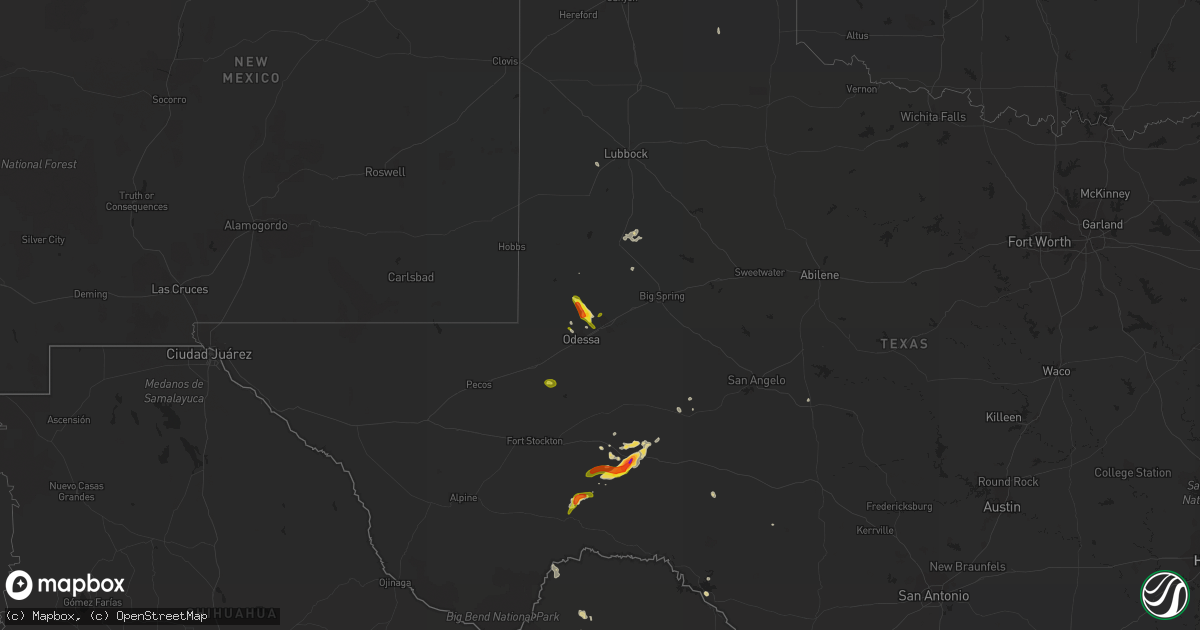
Hail Map on May 19, 2021
Get this storm
May 19 map
$229
one time, instant access
Download today. No call, no setup
Keep the $229
Bought the map and want the full workflow? Apply the entire $229 to a subscription within 7 days. None of it is wasted.
Every map, not just this one
This buys you this map. Subscription and you get every map we run, in the markets you choose from a few cities to whole states to nationwide. Plus real-time alerts the moment a storm fires.
Contact data
Name, contact info, occupancy, even credit band for addresses in the footprint. You go from where it hit to who to call.
Become the source they trust
Unlimited branding weather history reports on demand. You already have the documented answer ready for the property owner, and you are the one who showed up with it.
Property data and RoofTrace estimates
Pull up any address you have got, its value and the exact code rules for that jurisdiction, straight from One Click Code. Then RoofTrace estimates the squares, pitch, and roof value, priced the way you price.
States Impacted by Hail Map on May 19, 2021
Storm reports
North Dakota
| Date | Description |
|---|---|
| 05/19/20214:34 PM CDT | Tornado was on the ground until 4:44 pm. Tornado was confirmed by multiple reports. |
Louisiana
| Date | Description |
|---|---|
| 05/19/20216:29 AM CDT | At 1128 PM CDT, severe thunderstorms were located along a line extending from near Lacassine National Wildlife Refuge to near Lowry, moving north at 40 mph. HAZARD...60 mph wind gusts. SOURCE...Radar indicated. IMPACT...Expect damage to roofs, siding, and trees. Locations impacted include... Welsh, Iowa, Fenton, Lacassine National Wildlife Refuge, Hayes, Moss Bluff, Lebleu Settlement, Pine Island, Thornwell, Lowry, Holmwood, Bell City, Roanoke and Lacassine.This includes Interstate 10 in Louisiana between mile markers 36 and59. |
| 05/19/20215:54 AM CDT | At 1053 PM CDT, severe thunderstorms were located along a line extending from near Creole to 10 miles southeast of Rockefeller Wildlife Range, moving north at 60 mph. HAZARD...60 mph wind gusts. SOURCE...Radar indicated. IMPACT...Expect damage to roofs, siding, and trees. Locations impacted include... Lake Charles, Cameron, Westlake, Grand Lake, Lake Charles Regional Airport, Lacassine National Wildlife Refuge, Rockefeller Wildlife Range, Hayes, Grand Chenier, Hacketts Corner, Heberts Marina, Thornwell, Lowry, Creole, Sweet Lake, Gibbstown, Holmwood, Bell City and Rutherford Beach.This includes the following highways... Interstate 10 in Louisiana between mile markers 26 and 31. Interstate 210 between mile markers 2 and 10. |
| 05/19/20213:00 AM CDT | At 800 PM CDT, a severe thunderstorm was located over Hahnville, moving northwest at 15 mph. HAZARD...60 mph wind gusts. SOURCE...Radar indicated. IMPACT...Expect damage to roofs, siding, and trees. Locations impacted include... Reserve, Hahnville, Laplace, Killona, Norco, Montz, Edgard, Garyville, Taft, New Sarpy, Destrehan and Luling.This includes the following Interstates... Interstate 10 in Louisiana between mile markers 199 and 211. Interstate 55 in Louisiana between mile markers 1 and 3. Interstate 310 between mile markers 7 and 9. |
| 05/18/20219:15 PM CDT | At 215 AM CDT, a severe thunderstorm was located near Iowa, moving northeast at 45 mph. HAZARD...60 mph wind gusts. SOURCE...Radar indicated. IMPACT...Expect damage to roofs, siding, and trees. Locations impacted include... Lake Charles, Jennings, Welsh, Iowa, Elton, Fenton, Pine Island, Lebleu Settlement, Holmwood, Hathaway, Lacassine and Roanoke.This includes the following highways... Interstate 10 in Louisiana between mile markers 34 and 66. Interstate 210 between mile markers 11 and 12. |
| 05/18/20217:45 PM CDT | Roof and tree damage on wade st and st john st. Possible tornado. Time estimated from radar. |
Utah
| Date | Description |
|---|---|
| 05/19/20216:36 PM CDT | Small trees snapped in half |
| 05/19/20216:25 PM CDT | Flight park south sensor. |
| 05/18/202110:45 PM CDT | Great salt lake minerals sensor gslm |
| 05/18/20219:45 PM CDT | Horizontal grid dpg08 sensor |
| 05/18/20219:15 PM CDT | Salt flats dpg15 sensor |
| 05/18/20218:40 PM CDT | Another microburst occurred at 0310z. |
Texas
| Date | Description |
|---|---|
| 05/19/20215:50 PM CDT | A local report indicates 1.25 inch wind near 7 NW MIDLAND |
| 05/19/20215:35 PM CDT | A garden shed in gardendale got destroyed by strong winds from a thunderstorm. |
| 05/19/20215:29 PM CDT | A local report indicates 2.50 inch wind near SHEFFIELD |
| 05/19/20215:28 PM CDT | A local report indicates 1.75 inch wind near SHEFFIELD |
| 05/19/20212:30 PM CDT | Delayed report of quarter sized hail. |
| 05/19/20212:13 PM CDT | Report from mping: 3-inch tree limbs broken; power poles broken. |
| 05/19/20211:45 PM CDT | Report received via social media of a tree down on a vehicle. Time estimated. |
| 05/19/20217:58 AM CDT | At 1257 AM CDT, severe thunderstorms were located along a line extending from Cross to 9 miles east of Seven Sisters, moving northeast at 70 mph. HAZARD...Ping pong ball size hail and 60 mph wind gusts. SOURCE...Radar indicated. IMPACT...People and animals outdoors will be injured. Expect hail damage to roofs, siding, windows, and vehicles. Expect wind damage to roofs, siding, and trees. Locations impacted include... Beeville, Mathis, George West, Three Rivers, Tilden, Choke Canyon, Skidmore, Lake City, Midway, Cross, River Creek Acres, Tynan, Calliham, Annarose, Argenta, Karon, Rancho De La Parita, Mount Lucas, Pawnee and Simmons.This includes the following highways... Interstate 37 between mile markers 36 and 83. US Highway 281 between mile markers 618 and 656. US Highway 59 between mile markers 698 and 752. |
| 05/19/20217:35 AM CDT | At 1235 AM CDT, a severe thunderstorm was located near J B Thomas Reservoir, or 13 miles southwest of Snyder, moving southeast at 15 mph. HAZARD...60 mph wind gusts and quarter size hail. SOURCE...Radar indicated. IMPACT...Hail damage to vehicles is expected. Expect wind damage to roofs, siding, and trees. Locations impacted include... Colorado City Airport, J B Thomas Reservoir, Dunn, Ira, Cuthbert and Knapp. |
| 05/19/20217:33 AM CDT | At 1233 AM CDT, a severe thunderstorm was located near Sargent, or 16 miles south of Sweeny, moving northeast at 15 mph. HAZARD...Quarter size hail. SOURCE...Radar indicated. IMPACT...Damage to vehicles is expected. Locations impacted include... Jones Creek and Sargent. |
| 05/19/20217:29 AM CDT | At 1228 AM CDT, severe thunderstorms were located along a line extending from 13 miles south of Fowlerton to near Freer, moving north at 35 mph. HAZARD...Ping pong ball size hail and 60 mph wind gusts. SOURCE...Radar indicated. IMPACT...People and animals outdoors will be injured. Expect hail damage to roofs, siding, windows, and vehicles. Expect wind damage to roofs, siding, and trees. Locations impacted include... Freer, Tilden, Seven Sisters, Loma Alta and Cross. This includes US Highway 59 between mile markers 746 and 772. |
| 05/19/20217:17 AM CDT | At 1216 AM CDT, a severe thunderstorm was located over Tivoli, or 10 miles west of Seadrift, moving northeast at 35 mph. HAZARD...Ping pong ball size hail. SOURCE...Radar indicated. IMPACT...People and animals outdoors will be injured. Expect damage to roofs, siding, windows, and vehicles. Locations impacted include... Port Lavaca, Point Comfort, Alamo Beach, Green Lake, Magnolia Beach, Tivoli, Long Mott and Austwell.This includes US Highway 87 between mile markers 830 and 840. |
| 05/19/20213:58 AM CDT | At 858 AM CDT, severe thunderstorms were located along a line extending from 7 miles east of Airport Road Addition to 7 miles north of Lasara to Santa Ana National Wildlife Refuge, moving east at 30 mph. HAZARD...60 mph wind gusts. SOURCE...Radar indicated. IMPACT...Expect damage to roofs, siding, and trees. Locations impacted include... Edinburg, Mission, Pharr, Harlingen, Weslaco, San Juan, San Benito, Alamo, Donna and Mercedes.This includes the following highways... Interstate Highway 69 E between mile markers 15 and 51. Interstate Highway 69 C between mile markers 1 and 12. US Highway 77 between mile markers 710 and 762. US Highway 281 between mile markers 710 and 764. US Highway 281 between mile markers 784 and 828. |
| 05/19/20213:21 AM CDT | At 820 AM CDT, severe thunderstorms were located along a line extending from 15 miles northwest of Encino to Madero, moving east around 40 to 50 mph. HAZARD...60 mph wind gusts. SOURCE...Radar indicated. IMPACT...Expect damage to roofs, siding, and trees. Locations impacted include... Edinburg, Mission, Pharr, Harlingen, Weslaco, San Juan, Alamo, Donna, Mercedes and Raymondville.This includes the following highways... US Highway 83 between mile markers 832 and 850. Interstate Highway 69 E between mile markers 35 and 46. Interstate Highway 69 C between mile markers 1 and 12. US Highway 281 between mile markers 710 and 764. US Highway 281 between mile markers 784 and 818. |
| 05/19/20213:19 AM CDT | At 819 AM CDT, a severe thunderstorm was located 16 miles northeast of Andrews, moving northeast at 20 mph. HAZARD...60 mph wind gusts and quarter size hail. SOURCE...Radar indicated. IMPACT...Hail damage to vehicles is expected. Expect wind damage to roofs, siding, and trees. Locations impacted include... Patricia and Klondike. |
| 05/19/20212:47 AM CDT | At 747 AM CDT, severe thunderstorms were located along a line extending from 12 miles southeast of South Fork Estates to near Los Ebanos, moving southeast at 35 mph. HAZARD...60 mph wind gusts. SOURCE...Radar indicated. IMPACT...Expect damage to roofs, siding, and trees. Locations impacted include... Mission, Pharr, Rio Grande City, Hidalgo, Palmview, Penitas, Sullivan City, La Joya, Palmhurst and Garciasville.This includes the following highways... US Highway 83 between mile markers 818 and 850. Interstate Highway 69 C between mile markers 1 and 3. US Highway 281 between mile markers 784 and 792. |
| 05/19/20212:27 AM CDT | At 726 AM CDT, a severe thunderstorm was located near Rio Grande City Municipal Airport, or 7 miles southeast of El Sauz, moving east at 30 mph. HAZARD...60 mph wind gusts. SOURCE...Radar indicated. IMPACT...Expect damage to roofs, siding, and trees. Locations impacted include... Rio Grande City, Roma, Escobares, El Sauz, Viboras, Lopeno, Garciasville, La Rosita, New Falcon and La Victoria.This includes US Highway 83 between mile markers 784 and 834. |
| 05/19/20212:11 AM CDT | At 711 AM CDT, a severe thunderstorm was located near Santa Cruz, or 7 miles south of Rio Grande City, moving east at 25 mph. HAZARD...60 mph wind gusts and nickel size hail. SOURCE...Radar indicated. IMPACT...Expect damage to roofs, siding, and trees. Locations impacted include... Penitas, Sullivan City, La Joya, Los Ebanos, Garciasville, La Grulla, La Puerta, Jimmy Carter High School, John F Kennedy Elementary School and La Victoria.This includes US Highway 83 between mile markers 824 and 848. |
| 05/19/20211:51 AM CDT | At 651 AM CDT, a severe thunderstorm was located over Fronton, or near Roma, moving east at 50 mph. HAZARD...60 mph wind gusts and nickel size hail. SOURCE...Radar indicated. IMPACT...Expect damage to roofs, siding, and trees. Locations impacted include... Rio Grande City, Roma, Escobares, El Sauz, Garciasville, La Rosita, La Victoria, Los Alvarez, Fort Ringgold County Park and Garceno.This includes US Highway 83 between mile markers 794 and 834. |
| 05/19/20211:41 AM CDT | At 640 AM CDT, a severe thunderstorm was located near Mathis, moving northwest at 15 mph. HAZARD...60 mph wind gusts and penny size hail. SOURCE...Radar indicated. IMPACT...Expect damage to roofs, siding, and trees. This severe thunderstorm will be near... Sandia around 650 AM CDT. Mathis around 655 AM CDT. Lake City around 700 AM CDT. Argenta around 710 AM CDT. Lagarto around 720 AM CDT. Mount Lucas and Dinero around 730 AM CDT.Other locations impacted by this severe thunderstorm include LakeCorpus Christi, Pernitas Point and Lakeside.This includes Interstate 37 between mile markers 28 and 49. |
| 05/19/20211:35 AM CDT | At 635 PM CDT, a severe thunderstorm was located 8 miles west of Barnhart, or 9 miles east of Big Lake, moving southwest at 10 mph. HAZARD...60 mph wind gusts and quarter size hail. SOURCE...Radar indicated. IMPACT...Hail damage to vehicles is expected. Expect wind damage to roofs, siding, and trees. This severe thunderstorm will remain over mainly rural areas of southeastern Reagan County. |
| 05/19/20211:27 AM CDT | At 626 AM CDT, severe thunderstorms were located along a line extending from 6 miles north of Guerra to 8 miles north of Agua Nueva, moving northwest at 35 mph. HAZARD...60 mph wind gusts and quarter size hail. SOURCE...Radar indicated. IMPACT...Hail damage to vehicles is expected. Expect wind damage to roofs, siding, and trees.PRECAUTIONARY/PREPAREDNESS ACTIONS...Prepare immediately for large hail and damaging winds. People outsideshould move immediately to shelter inside a strong building. Stayaway from windows.Large hail and damaging winds and continuous cloud to groundlightning is occurring with these storms. Move indoors immediately.Lightning is one of nature's leading killers. Remember, if you canhear thunder, you are close enough to be struck by lightning. |
| 05/19/20211:07 AM CDT | At 607 AM CDT, a severe thunderstorm was located near Luther, or 10 miles northeast of Big Spring, moving east at 15 mph. HAZARD...60 mph wind gusts and quarter size hail. SOURCE...Radar indicated. IMPACT...Hail damage to vehicles is expected. Expect wind damage to roofs, siding, and trees. Locations impacted include... Coahoma, Luther and Vincent. This includes Interstate 20 between mile markers 190 and 201. |
| 05/19/20211:05 AM CDT | At 605 PM CDT, a severe thunderstorm was located 8 miles east of Goldsmith, or 9 miles northwest of Odessa, moving south at 20 mph. HAZARD...60 mph wind gusts and quarter size hail. SOURCE...Radar indicated. IMPACT...Hail damage to vehicles is expected. Expect wind damage to roofs, siding, and trees. Locations impacted include... Odessa, West Odessa and Odessa Schlemeyer Field. This includes Interstate 20 between mile markers 104 and 121. |
| 05/19/202112:27 AM CDT | At 526 PM CDT, a severe thunderstorm was located 9 miles northwest of Midland International Air and Space Port, or 11 miles west of Midland, moving southeast at 20 mph. HAZARD...Golf ball size hail and 70 mph wind gusts. SOURCE...Radar indicated. IMPACT...People and animals outdoors will be injured. Expect hail damage to roofs, siding, windows, and vehicles. Expect considerable tree damage. Wind damage is also likely to mobile homes, roofs, and outbuildings. Locations impacted include... Midland, East Odessa, Midland International Air and Space Port, Warfield, and Cotton Flat.This includes Interstate 20 between mile markers 116 and 138. |
| 05/18/202111:54 PM CDT | At 453 PM CDT, a severe thunderstorm was located 14 miles southwest of Sheffield, moving east at 25 mph. Another severe storm is in eastern Pecos County, just south of I-10. HAZARD...60 mph wind gusts and quarter size hail. SOURCE...Radar indicated. IMPACT...Hail damage to vehicles is expected. Expect wind damage to roofs, siding, and trees. Locations impacted include... Sheffield, Iraan and Iraan Municipal Airport. This includes Interstate 10 between mile markers 298 and 327. |
| 05/18/202111:50 PM CDT | At 449 PM CDT, a severe thunderstorm was located 11 miles southeast of Andrews, moving southeast at 15 mph. HAZARD...60 mph wind gusts and quarter size hail. SOURCE...Radar indicated. IMPACT...Hail damage to vehicles is expected. Expect wind damage to roofs, siding, and trees. Locations impacted include... Midland. |
| 05/18/202111:36 PM CDT | At 435 PM CDT, a severe thunderstorm was located 14 miles northwest of Crane, moving northeast at 20 mph. HAZARD...60 mph wind gusts and quarter size hail. SOURCE...Radar indicated. IMPACT...Hail damage to vehicles is expected. Expect wind damage to roofs, siding, and trees. Locations impacted include... Pleasant Farms. |
| 05/18/202111:14 PM CDT | At 414 PM CDT, a severe thunderstorm was located 21 miles west of Terrell County Gas Plant, or 23 miles northeast of Sanderson, moving northeast at 25 mph. HAZARD...60 mph wind gusts and quarter size hail. SOURCE...Radar indicated. IMPACT...Hail damage to vehicles is expected. Expect wind damage to roofs, siding, and trees. This severe thunderstorm will remain over mainly rural areas of east central Pecos and northeastern Terrell Counties. |
| 05/18/202110:36 PM CDT | At 335 PM CDT, a severe thunderstorm was located 13 miles northeast of Grandfalls, or 17 miles west of Crane, moving east at 35 mph. HAZARD...60 mph wind gusts and quarter size hail. SOURCE...Radar indicated. IMPACT...Hail damage to vehicles is expected. Expect wind damage to roofs, siding, and trees. Locations impacted include... Crane, McCamey, King Mountain, Cordona Lake and Crane County Airport. |
| 05/18/202110:27 PM CDT | At 327 PM CDT, a severe thunderstorm was located 8 miles north of Sanderson, moving east at 30 mph. HAZARD...60 mph wind gusts and quarter size hail. SOURCE...Radar indicated. IMPACT...Hail damage to vehicles is expected. Expect wind damage to roofs, siding, and trees. This severe thunderstorm will remain over mainly rural areas of south central Pecos and central Terrell Counties. |
| 05/18/202110:25 PM CDT | At 325 AM CDT, severe thunderstorms located near Ganado, or near Edna, moving east at 50-60 mph. HAZARD...60 mph wind gusts and penny size hail. SOURCE...Radar indicated. IMPACT...Expect damage to roofs, siding, and trees. Locations impacted include... Western Rosenberg, Bay City, Port Lavaca, El Campo, Wharton, Edna, Palacios, South Texas Nuclear Plant, East Bernard, Ganado, Beasley, Kendleton, La Ward, Pierce, Van Vleck, Boling-Iago, Lolita, Blessing, Markham and Cordele. |
| 05/18/20217:07 PM CDT | A local report indicates 58 MPH wind near 6 SE WELLINGTON |
South Dakota
| Date | Description |
|---|---|
| 05/19/20212:17 AM CDT | At 717 PM MDT, a severe thunderstorm was located over Fairpoint, or 40 miles southwest of Faith, moving northwest at 10 mph. HAZARD...Quarter size hail. SOURCE...Radar indicated. IMPACT...Damage to vehicles is expected. Hail may accumulate on roadways causing hazardous travel. This severe thunderstorm will be near... Fairpoint around 720 PM MDT. |
New Mexico
| Date | Description |
|---|---|
| 05/18/20217:00 PM CDT | Time estimated. Likely a small microburst or gustnado. |
Minnesota
| Date | Description |
|---|---|
| 05/18/20218:42 PM CDT | Reported as rain wrapped. Report relayed by scott county 911. |
| 05/18/20218:27 PM CDT | Relayed by rice county skywarn. Approximate location near webster. |
| 05/18/20218:21 PM CDT | Relayed by rice county skywarn. Storm chaser saw trees downed. |
| 05/18/20218:01 PM CDT | Crossed highway 19 4 ene henderson along the scott le sueur county line. |
| 05/18/20217:45 PM CDT | Separate tornado from the other one 3 e morristown. The tornadoes were separated by about one mile. Both were photographed and caught on video by a longtime spotter. |
| 05/18/20217:45 PM CDT | Trees down. No structures were damaged. Caught on pictures and video. This was a brief touchdown. Another funnel was close by but could not see whether that touched dow |
| 05/18/20217:43 PM CDT | One of two tornadoes west of owatonna. Location approximate. Went north toward medford. |
| 05/18/20217:43 PM CDT | Second of two tornadoes west of owatonna. Location approximate. |
| 05/18/20217:25 PM CDT | Corrects approximate time of previous tornado report from 3 w owatonna. One of two tornadoes west of owatonna. Location approximate. Went north toward medford. |
| 05/18/20217:25 PM CDT | Corrects approximate time of previous tornado report from 4 w owatonna. Second of two tornadoes west of owatonna. Location approximate. |
Cities Impacted by Hail Map on May 19, 2021
- Dryden, TX
- Sheffield, TX
- Ozona, TX
- Ropesville, TX
- Midland, TX
- Gardendale, TX
- Fort Stockton, TX
- Big Lake, TX
- Barnhart, TX
- Iraan, TX
- Kensal, ND
- Tappen, ND
- Braddock, ND
- Rocksprings, TX
- Lamesa, TX
- Union Center, SD
- Del Rio, TX
- Sonora, TX
- Lakeview, TX
- Eden, TX
- Kintyre, ND
- Marathon, TX
- Clarendon, TX
- Lenorah, TX
- Linton, ND
- Santa Elena, TX
- Hebbronville, TX
- Delmita, TX
- Linn, TX
- Concepcion, TX
- Rio Grande City, TX
- Encino, TX
- Falfurrias, TX
- Premont, TX
- San Isidro, TX
- Edinburg, TX
- Crane, TX
- Andrews, TX
- Owatonna, MN
- Faribault, MN