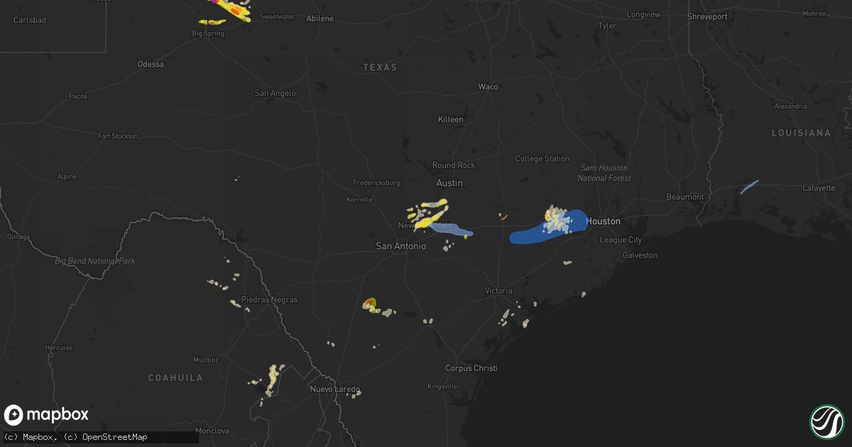
Hail Map on May 18, 2021
Get this storm
May 18 map
$229
one time, instant access
Download today. No call, no setup
Keep the $229
Bought the map and want the full workflow? Apply the entire $229 to a subscription within 7 days. None of it is wasted.
Every map, not just this one
This buys you this map. Subscription and you get every map we run, in the markets you choose from a few cities to whole states to nationwide. Plus real-time alerts the moment a storm fires.
Contact data
Name, contact info, occupancy, even credit band for addresses in the footprint. You go from where it hit to who to call.
Become the source they trust
Unlimited branding weather history reports on demand. You already have the documented answer ready for the property owner, and you are the one who showed up with it.
Property data and RoofTrace estimates
Pull up any address you have got, its value and the exact code rules for that jurisdiction, straight from One Click Code. Then RoofTrace estimates the squares, pitch, and roof value, priced the way you price.
States Impacted by Hail Map on May 18, 2021
Storm reports
New Mexico
| Date | Description |
|---|---|
| 05/17/20219:21 PM CDT | At 221 PM MDT, a severe thunderstorm was located 11 miles west of Sedan, or 20 miles northwest of Amistad, moving north at 10 mph. HAZARD...60 mph wind gusts and quarter size hail. SOURCE...Radar indicated. IMPACT...Hail damage to vehicles is expected. Expect wind damage to roofs, siding, and trees. This severe thunderstorm will remain over mainly rural areas of east central Union County. |
| 05/17/20219:16 PM CDT | At 215 PM MDT, a severe thunderstorm was located 14 miles west of Portales, moving northeast at 10 mph. HAZARD...60 mph wind gusts and quarter size hail. SOURCE...Radar indicated. IMPACT...Hail damage to vehicles is expected. Expect wind damage to roofs, siding, and trees. Locations impacted include... Portales and Floyd. |
Colorado
| Date | Description |
|---|---|
| 05/17/20218:28 PM CDT | At 128 PM CDT, a severe thunderstorm was located 8 miles west of Boise City, moving northwest at 20 mph. HAZARD...60 mph wind gusts and half dollar size hail. SOURCE...Radar indicated. IMPACT...Minor damage to roofs, siding, and trees is possible. Hail damage to vehicles is expected. Locations impacted include... Kenton, Wheeless, Black Mesa Park and Felt. |
Mississippi
| Date | Description |
|---|---|
| 05/18/20213:53 PM CDT | Corrects source from previous tornado report from 1 n pinola. This ef0 tornado touched just north of pinola along robert bush road... Where a tornado debris signature w |
| 05/18/20213:20 PM CDT | Corrects previous tornado report from 2 n pinola. Possible tornado - trees uprooted and snapped. Several limbs down. |
| 05/18/20212:59 PM CDT | Corrects date from previous tornado report from 1 nne prentiss. This ef0 tornado touched down along 2nd street and blount avenue in the northwest side of town in prenti |
| 05/18/20212:58 PM CDT | Possible tornado. Tree on house. Tree snapped near elementary school. |
| 05/18/20212:26 PM CDT | Possible tornado - trees twisted... Tin roof blown off of 2 apartment buildings... Limbs broken. |
| 05/18/20212:16 PM CDT | This ef1 tornado developed along n archusa ave near the intersection with n jackson ave and tracked northward roughly along highway 145... Crossing cr 141 and moving ac |
Louisiana
| Date | Description |
|---|---|
| 05/18/20212:35 AM CDT | Campers turned over near iowa... La. |
| 05/18/20212:10 AM CDT | 69 mph wind gust reported by the asos at the nws office. |
| 05/18/20212:00 AM CDT | Chimney came off of a house west of the lake charles regional airport. |
| 05/18/202112:26 AM CDT | At 525 AM CDT, a severe thunderstorm was located near Belle Chasse, moving northeast at 20 mph. HAZARD...60 mph wind gusts. SOURCE...Radar indicated. IMPACT...Expect damage to roofs, siding, and trees. Locations impacted include... New Orleans, Chalmette, Marrero, Harvey, East New Orleans, Timberlane, Belle Chasse, Metairie, Jefferson, Gretna, Westwego, Woodmere, Violet, Terrytown, Meraux, Poydras, Estelle, Arabi, Bridge City and Lakefront Airport.This includes the following Interstates... Interstate 10 in Louisiana between mile markers 231 and 248. Interstate 510 between mile markers 1 and 3. Interstate 610 between mile markers 1 and 4. |
| 05/17/202110:17 PM CDT | At 317 AM CDT, a severe thunderstorm was located near St. Rose, or near Metairie, moving north at 35 mph. HAZARD...60 mph wind gusts. SOURCE...Radar indicated. IMPACT...Expect damage to roofs, siding, and trees. Locations impacted include... Metairie, Jefferson, Harahan, Elmwood, River Ridge, St. Rose, Ama, Waggaman, Bridge City, Destrehan and New Orleans Armstrong Airport.This includes the following Interstates... Interstate 10 in Louisiana between mile markers 218 and 228. Interstate 310 between mile markers 1 and 4. |
Texas
| Date | Description |
|---|---|
| 05/18/20216:48 PM CDT | Phone calls from storm chasers reporting tornado on the ground...chaser video of a tornado on the ground...and later reported damage including powerlines down. Time and |
| 05/18/20216:28 PM CDT | A local report indicates 1.75 inch wind near 7 NNE LAMESA |
| 05/18/20216:03 PM CDT | Multiple reports of funnel cloud with rotating dust underneath for 3-5 minutes. Remained over open fields with no damage reported. |
| 05/18/20215:32 PM CDT | West texas mesonet |
| 05/18/20215:30 PM CDT | Brief landspout. No damage. |
| 05/18/20214:54 PM CDT | Video evidence and a nws storm survey confirmed a tornado touched down roughly one-mile northwest of sublime... South and east of cr 142. The tornado moved northwest an |
| 05/18/20214:50 PM CDT | Significant tree damage along with damage to a barn reported around sublime. |
| 05/18/20214:36 PM CDT | A local report indicates 1.00 inch wind near 2 N ASHMORE |
| 05/18/20214:23 PM CDT | Report from mping: quarter |
| 05/18/20214:20 PM CDT | Tree down on church street and power lines down. |
| 05/18/20214:20 PM CDT | Reports of damage including a few trees down and a trampoline thrown as well as several videos of strong winds from the buda area shared on local medias social media. T |
| 05/18/20214:09 PM CDT | A local report indicates 1.00 inch wind near 1 SE ADRIAN |
| 05/18/20214:09 PM CDT | Quarter hail reported in kyle with heavy rainfall. |
| 05/18/20213:50 PM CDT | A lot of nickel to quarter sized hail covering u.s. Hwy 83 east of seagraves. |
| 05/18/20213:36 PM CDT | 66 mph wind gusts reported by the new braunfels asos. Pea to dime sized wind driven hail. |
| 05/18/20213:24 PM CDT | Quarters and larger sized hail on the west side of new bruanfels from an nws employee. |
| 05/18/20212:14 PM CDT | A few long tree limbs down that were 4 to 5 inches in diameter in and around bulverde. |
| 05/18/20217:58 AM CDT | At 1258 AM CDT, a severe thunderstorm was located 11 miles south of Ramirez, or 13 miles west of Falfurrias, moving east at 35 mph. HAZARD...70 mph wind gusts and ping pong ball size hail. SOURCE...Radar indicated. IMPACT...People and animals outdoors will be injured. Expect hail damage to roofs, siding, windows, and vehicles. Expect considerable tree damage. Wind damage is also likely to mobile homes, roofs, and outbuildings. Locations impacted include... Falfurrias, Encino, Rachal, Agua Nueva, La Colonia Park, Airport Road Addition, Falfurrias Junior High School, Pleasant Park, Falfurrias Fire Station and Cantu Addition.This includes US Highway 281 between mile markers 708 and 734. |
| 05/18/20217:57 AM CDT | At 1257 AM CDT, severe thunderstorms were located along a line extending from near Benavides to near Falfurrias Junior High School, moving east at 45 mph. HAZARD...60 mph wind gusts and nickel size hail. SOURCE...Radar indicated. IMPACT...Expect damage to roofs, siding, and trees. Severe thunderstorms will be near... La Gloria around 105 AM CDT. Palito Blanco around 120 AM CDT. Ben Bolt around 130 AM CDT. Riviera around 135 AM CDT. Kingsville around 145 AM CDT.Other locations impacted by these severe thunderstorms include LakeAlice.This includes the following highways... US Highway 281 between mile markers 670 and 708. US Highway 77 between mile markers 694 and 708. |
| 05/18/20217:39 AM CDT | At 1238 AM CDT, severe thunderstorms were located along a line extending from 15 miles southwest of Freer to 7 miles southwest of Ramirez, moving east at 35 mph. HAZARD...60 mph wind gusts and nickel size hail. SOURCE...Radar indicated. IMPACT...Expect damage to roofs, siding, and trees. Severe thunderstorms will be near... Ramirez around 1245 AM CDT.This includes US Highway 59 near mile marker 798. |
| 05/18/20217:26 AM CDT | At 1226 AM CDT, a severe thunderstorm was located 8 miles south of South Fork Estates, or 10 miles south of Hebbronville, moving east at 35 mph. HAZARD...60 mph wind gusts and quarter size hail. SOURCE...Radar indicated. IMPACT...Hail damage to vehicles is expected. Expect wind damage to roofs, siding, and trees. Locations impacted include... Hebbronville, Agua Nueva, Las Lomitas, Gruy Stadium, Jim Hogg County Airport, Hebbronville High School, South Fork Estates and Hebbronville Border Patrol Station. |
| 05/18/20216:16 AM CDT | At 1115 PM CDT, a severe thunderstorm was located 8 miles southwest of Aguilares, or 21 miles southeast of Laredo, moving east at 25 mph. HAZARD...Ping pong ball size hail. SOURCE...Radar indicated. IMPACT...People and animals outdoors will be injured. Expect damage to roofs, siding, windows, and vehicles. Locations impacted include... Oilton, Mirando City and Aguilares. |
| 05/18/20216:10 AM CDT | A local report indicates 1.00 inch wind near 8 NW COAHOMA |
| 05/18/20214:51 AM CDT | At 951 PM CDT, severe thunderstorms were located along a line extending from Fairbanks / Northwest Crossing to near Sienna Plantation, moving east at 40 mph. HAZARD...60 mph wind gusts. SOURCE...Radar indicated. IMPACT...Expect damage to roofs, siding, and trees. Locations impacted include... Pasadena, Pearland, League City, Sugar Land, northwestern Baytown, Missouri City, Texas City, Friendswood, La Porte, Deer Park, southeastern Rosenberg, Alvin, Dickinson, Stafford, South Houston, Bellaire, West University Place, Seabrook, Richmond and Galena Park. |
| 05/18/20214:44 AM CDT | At 944 PM CDT, severe thunderstorms were located along a line extending from near Montgomery to near The Woodlands to near Hooks Airport, moving east at 30 mph. HAZARD...60 mph wind gusts. SOURCE...Radar indicated. IMPACT...Expect damage to roofs, siding, and trees. Locations impacted include... Conroe, Tomball, Willis, Pinehurst, The Woodlands, Spring, Oak Ridge North, Panorama Village, Shenandoah, Splendora, Patton Village, Magnolia, Woodbranch, Cut And Shoot, Montgomery, Stagecoach, Woodloch, The Woodlands Pavillion, Chateau Woods and Lake Conroe Dam. |
| 05/18/20214:38 AM CDT | At 937 PM CDT, a severe thunderstorm was located 7 miles west of Colorado City Airport, or 12 miles northwest of Colorado City, moving southeast at 25 mph. HAZARD...Golf ball size hail and 60 mph wind gusts. SOURCE...Radar indicated. IMPACT...People and animals outdoors will be injured. Expect hail damage to roofs, siding, windows, and vehicles. Expect wind damage to roofs, siding, and trees. Locations impacted include... Colorado City, Loraine, Colorado City Airport, Lake Colorado City, Lake Colorado City State Park, Inadale, Champion Creek Reservoir, Westbrook, Cuthbert, Buford, Dunn, Ira and Hermleigh.This includes Interstate 20 between mile markers 204 and 228. |
| 05/18/20214:25 AM CDT | At 924 PM CDT, a severe thunderstorm was located over Todd Mission, or 8 miles west of Pinehurst, moving northeast at 30 mph. HAZARD...60 mph wind gusts and quarter size hail. SOURCE...Radar indicated. IMPACT...Hail damage to vehicles is expected. Expect wind damage to roofs, siding, and trees. Locations impacted include... Tomball, Prairie View, Pinehurst, The Woodlands, Waller, Magnolia, Montgomery, Stagecoach, Todd Mission, Plantersville, Dobbin and Dacus. |
| 05/18/20214:10 AM CDT | At 910 PM CDT, severe thunderstorms were located along a line extending from Pine Island to Brookshire to near East Bernard, moving east at 30 mph. HAZARD...60 mph wind gusts and quarter size hail. SOURCE...Radar indicated. IMPACT...Hail damage to vehicles is expected. Expect wind damage to roofs, siding, and trees. Locations impacted include... Sugar Land, Rosenberg, Stafford, Katy, Richmond, Tomball, Jersey Village, Prairie View, Town West, Pecan Grove, Eldridge / West Oaks, Spring Branch West, First Colony, Addicks Park Ten, Mission Bend, Spring Branch North, Hockley, Meadows Place, Waller and Fulshear. |
| 05/18/20213:44 AM CDT | At 843 PM CDT, a severe thunderstorm was located 9 miles northwest of J B Thomas Reservoir, or 11 miles southeast of Gail, moving southeast at 25 mph. This is a very dangerous storm. HAZARD...80 mph wind gusts and tennis ball size hail. SOURCE...Radar indicated. IMPACT...Flying debris will be dangerous to those caught without shelter. Mobile homes will be heavily damaged. Expect considerable damage to roofs, windows, and vehicles. Extensive tree damage and power outages are likely. Locations impacted include... J B Thomas Reservoir, Ira, Vincent, Cuthbert and Knapp. |
| 05/18/20213:41 AM CDT | At 839 PM CDT, severe thunderstorms were located along a line extending from 9 miles west of Sealy to near Eagle Lake to 12 miles northwest of Pierce, moving east at 25 mph. HAZARD...60 mph wind gusts and quarter size hail. SOURCE...Radar indicated. IMPACT...Hail damage to vehicles is expected. Expect wind damage to roofs, siding, and trees. Locations impacted include... Western Rosenberg, Wharton, Sealy, Brookshire, Eagle Lake, East Bernard, Wallis, Fulshear, Simonton, San Felipe, Beasley, Pattison, Kendleton, Orchard, Weston Lakes, Monaville, Egypt, Cat Spring, Hungerford and Nada. |
| 05/18/20212:54 AM CDT | At 753 PM CDT, a severe thunderstorm was located near Gail, moving southeast at 25 mph. HAZARD...Tennis ball size hail and 70 mph wind gusts. SOURCE...Radar indicated. IMPACT...People and animals outdoors will be injured. Expect hail damage to roofs, siding, windows, and vehicles. Expect considerable tree damage. Wind damage is also likely to mobile homes, roofs, and outbuildings. Locations impacted include... Gail, J B Thomas Reservoir, Vincent, Knapp and Randalls Corner. |
| 05/18/20212:30 AM CDT | At 730 PM CDT, a severe thunderstorm was located 6 miles west of Skellytown, or 8 miles southeast of Borger, moving northeast at 20 mph. HAZARD...60 mph wind gusts and quarter size hail. SOURCE...Radar indicated. IMPACT...Minor damage to roofs, siding, and trees is possible. Hail damage to vehicles is expected. Locations impacted include... Borger, Stinnett, Skellytown and Pringle. |
| 05/18/20212:09 AM CDT | At 709 PM CDT, a severe thunderstorm was located 9 miles east of Lamesa Municipal Airport, or 12 miles east of Lamesa, moving east at 20 mph. HAZARD...Ping pong ball size hail and 60 mph wind gusts. SOURCE...Radar indicated. IMPACT...People and animals outdoors will be injured. Expect hail damage to roofs, siding, windows, and vehicles. Expect wind damage to roofs, siding, and trees. Locations impacted include... Key. |
| 05/18/20211:28 AM CDT | At 627 PM CDT, a severe thunderstorm was located near Lamesa Municipal Airport, or 8 miles northeast of Lamesa, moving east at 10 mph. HAZARD...Ping pong ball size hail and 60 mph wind gusts. SOURCE...Radar indicated. IMPACT...People and animals outdoors will be injured. Expect hail damage to roofs, siding, windows, and vehicles. Expect wind damage to roofs, siding, and trees. Locations impacted include... Hancock, Key and Arvana. |
| 05/18/202112:46 AM CDT | At 546 PM CDT, severe thunderstorms were located along a line extending from 5 miles south of Buffalo Lake to 3 miles northwest of Littlefield, moving east at 25 mph. HAZARD...60 mph wind gusts and quarter size hail. SOURCE...Radar indicated. IMPACT...Hail damage to vehicles is expected. Expect wind damage to roofs, siding, and trees. Locations impacted include... Littlefield, Tulia, Dimmitt, Olton, Hart, Earth, Amherst, Happy, Cotton Center, Fieldton, Halfway, Spade, Nazareth, Edmonson and Springlake. |
| 05/18/202112:44 AM CDT | At 543 PM CDT, a severe thunderstorm was located 9 miles southeast of Dilley, moving northeast at 20 mph. HAZARD...Golf ball size hail. SOURCE...Radar indicated. IMPACT...People and animals outdoors will be injured. Expect damage to roofs, siding, windows, and vehicles. This severe thunderstorm will remain over mainly rural areas of north central La Salle County. |
| 05/18/202112:42 AM CDT | At 541 PM CDT, a severe thunderstorm was located 9 miles east of Dilley, moving northeast at 15 mph. HAZARD...Golf ball size hail and 60 mph wind gusts. SOURCE...Radar indicated. IMPACT...People and animals outdoors will be injured. Expect hail damage to roofs, siding, windows, and vehicles. Expect wind damage to roofs, siding, and trees. Locations impacted include... Goldfinch, Schattel, Hindes and Davis. |
| 05/18/202112:41 AM CDT | At 541 PM CDT, a severe thunderstorm was located 8 miles southeast of New Moore, or 11 miles north of Lamesa, moving east at 20 mph. HAZARD...Golf ball size hail and 60 mph wind gusts. SOURCE...Radar indicated. IMPACT...People and animals outdoors will be injured. Expect hail damage to roofs, siding, windows, and vehicles. Expect wind damage to roofs, siding, and trees. Locations impacted include... Hancock, Key and Arvana. |
| 05/18/202112:19 AM CDT | At 519 PM CDT, severe thunderstorms were located along a line extending from 6 miles west of Valley De Oro to 4 miles south of Bushland, moving east at 20 mph. HAZARD...60 mph wind gusts and half dollar size hail. SOURCE...Radar indicated. IMPACT...Minor damage to roofs, siding, and trees is possible. Hail damage to vehicles is expected. Locations impacted include... Amarillo, Canyon, Lake Tanglewood, Bushland, Valley De Oro, Washburn, Boys Ranch, Mescalero Park, Four Way, Masterson, Lake Meredith, Timbercreek Canyon and Pantex. |
| 05/18/202112:03 AM CDT | At 501 AM CDT, severe thunderstorms were located along a line extending from near Silver to near Mertzon, moving east at 30 mph. HAZARD...60 mph wind gusts and quarter size hail. SOURCE...Radar indicated. IMPACT...Hail damage to vehicles is expected. Expect wind damage to roofs, siding, and trees. Severe thunderstorms will be near... Silver around 510 AM CDT. Sanco around 530 AM CDT. San Angelo and Christoval around 540 AM CDT. Blackwell and Fort Chadbourne around 600 AM CDT.Other locations impacted by these severe thunderstorms include TheIntersection Of Highway 208 And Ranch Road 2662, The Intersection OfHighway 158 And Ranch Road 2059, Us-87 Near The Coke-Tom Green County Line, Us-67 Near The Irion-Tom Green County Line and Oak Creek Reservoir. |
| 05/17/202111:58 PM CDT | At 458 PM CDT, a severe thunderstorm was located near Welch, or 18 miles northwest of Lamesa, moving east at 20 mph. HAZARD...60 mph wind gusts and half dollar size hail. SOURCE...Radar indicated. IMPACT...Hail damage to vehicles is expected. Expect wind damage to roofs, siding, and trees. Locations impacted include... Lamesa, Welch, Lamesa Municipal Airport, Los Ybanez, Punkin Center, Arvana and Hancock. |
| 05/17/202111:45 PM CDT | Broken tree limbs... Snapped power poles... And downed trees reported by public on social media due to strong winds at around 11:45 pm cdt. |
| 05/17/202111:39 PM CDT | At 439 PM CDT, a severe thunderstorm was located near Gonzales, moving east at 20 mph. HAZARD...60 mph wind gusts and quarter size hail. SOURCE...Radar indicated. IMPACT...Hail damage to vehicles is expected. Expect wind damage to roofs, siding, and trees. Locations impacted include... Gonzales, Flatonia, Moulton, Waelder, Muldoon, Komensky, Freyburg, Henkhaus, Moravia, Newtonville, Elm Grove, Engle, O'Quinn, Breslau, Nickle, Dilworth, Floy, Witting, Little New York and Thompsonville. |
| 05/17/202111:30 PM CDT | Multiple trees down in the devers area. |
| 05/17/202111:27 PM CDT | At 427 PM CDT, severe thunderstorms were located along a line extending from Austin Bergstrom Int Airport to near Palmeto State Park, moving northeast at 35 mph. HAZARD...60 mph wind gusts and quarter size hail. SOURCE...Radar indicated. IMPACT...Hail damage to vehicles is expected. Expect wind damage to roofs, siding, and trees. Locations impacted include... Austin, Lockhart, Elgin, Bastrop, Luling, Smithville, Austin Bergstrom Int Airport, Waelder, Mustang Ridge, Niederwald, Camp Swift, Circle D-KC Estates, Cedar Creek, Rosanky, Paige, Muldoon, Cistern, Wyldwood, Palmeto State Park and Hornsby Bend. |
| 05/17/202111:25 PM CDT | Public reports on social media of trees down and broken tree limbs near wayside drive and tidwell road in northeast houston around 11:25 pm cdt. |
| 05/17/202111:24 PM CDT | At 423 PM CDT, a severe thunderstorm was located 13 miles north of Nixon, or 15 miles southeast of Seguin, moving northeast at 15 mph. HAZARD...60 mph wind gusts and quarter size hail. SOURCE...Radar indicated. IMPACT...Hail damage to vehicles is expected. Expect wind damage to roofs, siding, and trees. Locations impacted include... Gonzales, Luling, Palmeto State Park, Leesville, Little New York, Oak Forest, Ottine, Belmont, Bebe, McNeil, Cost and Monthalia. |
| 05/17/202111:18 PM CDT | At 415 AM CDT, severe thunderstorms were located along a line extending from near Big Lake to 10 miles northwest of Sterling City, moving southeast at 30 mph. HAZARD...60 mph wind gusts and quarter size hail. SOURCE...Radar indicated. IMPACT...Hail damage to vehicles is expected. Expect wind damage to roofs, siding, and trees. Severe thunderstorms will be near... Barnhart around 445 AM CDT. Sterling City around 450 AM CDT. |
| 05/17/202111:15 PM CDT | Multiple trees down around angleton. |
| 05/17/202111:15 PM CDT | City of houston emergency management reports several trees down across northeast houston stretching from trinity and houston gardens to mount houston to greenwood park. |
| 05/17/202111:15 PM CDT | At 415 PM CDT, a severe thunderstorm was located 7 miles east of Seagraves Airport, or 9 miles east of Seagraves, moving northeast at 15 mph. HAZARD...Ping pong ball size hail and 60 mph wind gusts. SOURCE...Radar indicated. IMPACT...People and animals outdoors will be injured. Expect hail damage to roofs, siding, windows, and vehicles. Expect wind damage to roofs, siding, and trees. Locations impacted include... Loop. |
| 05/17/202111:00 PM CDT | City of houston emergency management reports several trees down across the heights region of northwest houston. |
| 05/17/202111:00 PM CDT | At 359 PM CDT, a severe thunderstorm was located 7 miles southeast of Adrian, or 8 miles west of Vega, moving northeast at 25 mph. HAZARD...60 mph wind gusts and quarter size hail. SOURCE...Radar indicated. IMPACT...Minor damage to roofs, siding, and trees is possible. Hail damage to vehicles is expected. Locations impacted include... Vega, Boys Ranch, Wildorado and Valley De Oro. |
| 05/17/202111:00 PM CDT | City of houston emergency management reports several trees down across the river oaks and montrose areas of houston. |
| 05/17/202110:55 PM CDT | Corrects previous tstm wnd dmg report from 1 ssw crosby. Broken tree limbs... Snapped power poles... And downed trees reported by public on social media due to strong w |
| 05/17/202110:53 PM CDT | At 352 AM CDT, a line of severe thunderstorms was located south of Garden City extending back to Crane, moving southeast at 25 mph. HAZARD...60 mph wind gusts and quarter size hail. SOURCE...Radar indicated. IMPACT...Hail damage to vehicles is expected. Expect wind damage to roofs, siding, and trees. Locations impacted include... Crane, McCamey, Rankin, Stiles, Midkiff, Crane County Airport, Best, Upton County Airport, Saint Lawrence and King Mountain. |
| 05/17/202110:50 PM CDT | City of houston emergency management reports several trees down across the mission bend region of southwest houston. |
| 05/17/202110:44 PM CDT | At 344 AM CDT, a severe thunderstorm was located over Lomax, or 12 miles southwest of Big Spring, moving northeast at 25 mph. This storm has a history of producing winds in excess of 80 mph near Lomax. This is a very dangerous storm. HAZARD...80 mph wind gusts and quarter size hail. SOURCE...Radar indicated. IMPACT...Flying debris will be dangerous to those caught without shelter. Mobile homes will be heavily damaged. Expect considerable damage to roofs, windows, and vehicles. Extensive tree damage and power outages are likely. Locations impacted include... Big Spring, Stanton, Lomax, Big Spring Country Club, Elbow and Big Spring McMahon-Wrinkle Airpark.This includes Interstate 20 between mile markers 159 and 184. |
| 05/17/202110:40 PM CDT | At 339 PM CDT, severe thunderstorms were located along a line extending from near Driftwood to near Zorn, moving east at 25 mph. HAZARD...60 mph wind gusts and quarter size hail. SOURCE...Radar indicated. IMPACT...Hail damage to vehicles is expected. Expect wind damage to roofs, siding, and trees. Locations impacted include... Austin, San Marcos, Kyle, Buda, Lockhart, Wimberley, Austin Bergstrom Int Airport, Woodcreek, Martindale, Uhland, Mustang Ridge, Niederwald, Onion Creek, Shady Hollow, Manchaca, Mountain City, San Leanna, Hays, Creedmoor and Maha. |
| 05/17/202110:35 PM CDT | At 334 PM CDT, a severe thunderstorm was located near New Braunfels, moving east at 25 mph. HAZARD...60 mph wind gusts and quarter size hail. SOURCE...Radar indicated. IMPACT...Hail damage to vehicles is expected. Expect wind damage to roofs, siding, and trees. Locations impacted include... New Braunfels, Seguin, Lockhart, Luling, McQueeney, Martindale, Kingsbury, Staples, Fentress, Geronimo, Zorn, Brownsboro, Hunter, Joliet, Stairtown, McNeil, Redwood, Freiheit, Gruene and New Braunfels Regional Airport. |
| 05/17/202110:30 PM CDT | Corrects previous tstm wnd dmg report from 6 nw jacinto city. City of houston emergency management reports several trees down across northeast houston stretching from t |
| 05/17/202110:30 PM CDT | Corrects previous tstm wnd dmg report from 6 nnw jacinto city. Public reports on social media of trees down and broken tree limbs near wayside drive and tidwell road in |
| 05/17/202110:29 PM CDT | At 329 PM CDT, a severe thunderstorm was located over Seagraves, moving northeast at 10 mph. HAZARD...60 mph wind gusts and quarter size hail. SOURCE...Radar indicated. IMPACT...Hail damage to vehicles is expected. Expect wind damage to roofs, siding, and trees. Locations impacted include... Seagraves, Seagraves Airport and Loop. |
| 05/17/202110:15 PM CDT | Corrects previous tstm wnd dmg report from 2 n west university place. City of houston emergency management reports several trees down across the heights region of north |
| 05/17/202110:15 PM CDT | Corrects previous tstm wnd dmg report from 1 ene west university place. City of houston emergency management reports several trees down across the river oaks and montro |
| 05/17/202110:15 PM CDT | Multiple trees down in the cut and shoot area. |
| 05/17/20219:55 PM CDT | Multiple trees down in the neighborhood. |
| 05/17/20219:54 PM CDT | A local report indicates 1.00 inch wind near 2 SW CUTHBERT |
| 05/17/20219:53 PM CDT | At 253 PM CDT, a severe thunderstorm was located 13 miles south of Glenrio, or 27 miles northwest of Friona, moving northeast at 10 mph. HAZARD...60 mph wind gusts and half dollar size hail. SOURCE...Radar indicated. IMPACT...Minor damage to roofs, siding, and trees is possible. Hail damage to vehicles is expected. Locations impacted include... Adrian, Glenrio, Bootleg and Simms. |
| 05/17/20219:51 PM CDT | At 250 PM CDT, a severe thunderstorm was located 7 miles southwest of Seagraves, moving northeast at 25 mph. HAZARD...60 mph wind gusts and quarter size hail. SOURCE...Radar indicated. IMPACT...Hail damage to vehicles is expected. Expect wind damage to roofs, siding, and trees. Locations impacted include... Seagraves, Seagraves Airport and Gaines County Park. |
| 05/17/20219:50 PM CDT | Corrects previous tstm wnd dmg report from 1 nw town west. City of houston emergency management reports several trees down across the mission bend region of southwest h |
| 05/17/20219:46 PM CDT | At 246 PM CDT, severe thunderstorms were located along a line extending from near Fischer to near Smithson Valley, moving east at 20 mph. HAZARD...60 mph wind gusts and nickel size hail. SOURCE...Radar indicated. IMPACT...Expect damage to roofs, siding, and trees. Locations impacted include... New Braunfels, San Marcos, Wimberley, Canyon Lake Dam, Canyon Lake, Bulverde, Woodcreek, Smithson Valley, Fischer, Hunter, Startzville, Sattler, Freiheit, Gruene, Hays City and New Braunfels Regional Airport. |
| 05/17/20219:44 PM CDT | A local report indicates 1.00 inch wind near 2 ESE CUTHBERT |
| 05/17/20219:43 PM CDT | At 242 AM CDT, a line of severe thunderstorms was located 9 miles northeast of Crane to south of Stanton, moving northeast at 10 mph. HAZARD...Ping pong ball size hail and 60 mph wind gusts. SOURCE...Radar indicated. IMPACT...People and animals outdoors will be injured. Expect hail damage to roofs, siding, windows, and vehicles. Expect wind damage to roofs, siding, and trees. Locations impacted include... Crane, Greenwood, Garden City, Lomax, Midkiff, Crane County Airport, Saint Lawrence, Skywest Airport, King Mountain, Spraberry and Pleasant Farms.This includes Interstate 20 between mile markers 160 and 172. |
| 05/17/20219:40 PM CDT | Trees down along fm 149 near keenan cutoff road and lake creek. |
| 05/17/20219:32 PM CDT | A local report indicates 1.75 inch wind near 14 NW COLORADO CITY |
| 05/17/20219:30 PM CDT | At 230 AM CDT, a severe thunderstorm was located 14 miles east of Grandfalls, or 15 miles west of Crane, moving east at 15 mph. HAZARD...Ping pong ball size hail and 60 mph wind gusts. SOURCE...Radar indicated. IMPACT...People and animals outdoors will be injured. Expect hail damage to roofs, siding, windows, and vehicles. Expect wind damage to roofs, siding, and trees. Locations impacted include... Crane, Imperial, Cordona Lake and Crane County Airport. |
| 05/17/20219:25 PM CDT | Trees down different parts of the city. |
| 05/17/20219:16 PM CDT | Emergency manager reports funnel cloud with dust cloud underneath looking wnw from ranch rd 1229. No damage reported... Preliminary rating efu. |
| 05/17/20219:16 PM CDT | At 216 AM CDT, severe thunderstorms were located along a line extending from near Dinero to West Sinton to near Annaville, moving northeast at 50 mph. HAZARD...60 mph wind gusts and penny size hail. SOURCE...Radar indicated. IMPACT...Expect damage to roofs, siding, and trees. Severe thunderstorms will be near... Odem around 220 AM CDT. St. Paul, Papalote and Tynan around 225 AM CDT. Sinton, Taft and Skidmore around 230 AM CDT.Other locations impacted by these severe thunderstorms includePernitas Point, Lake Corpus Christi, North San Pedro, Taft Southwestand Lakeside.This includes the following highways... Interstate 37 between mile markers 11 and 49. US Highway 281 between mile markers 644 and 646. US Highway 181 between mile markers 600 and 630. US Highway 77 between mile markers 642 and 658. |
| 05/17/20219:11 PM CDT | At 211 AM CDT, a severe thunderstorm was located near Sylvester, moving east at 10 mph. HAZARD...Ping pong ball size hail and 60 mph wind gusts. SOURCE...Radar indicated. IMPACT...People and animals outdoors will be injured. Expect hail damage to roofs, siding, windows, and vehicles. Expect wind damage to roofs, siding, and trees. This severe thunderstorm will be near... Sylvester around 225 AM CDT. Mccaulley around 245 AM CDT. Neinda and Noodle around 315 AM CDT.Other locations impacted by this severe thunderstorm include TheIntersection Of Us-180 And Ranch Road 126. |
| 05/17/20219:10 PM CDT | Tree was downed on a vehicle along hwy. 69 near jacksonville. |
| 05/17/20218:59 PM CDT | At 159 AM CDT, a severe thunderstorm was located over Vancourt, moving east at 20 mph. HAZARD...Half dollar size hail. SOURCE...Radar indicated. IMPACT...Damage to vehicles is expected. This severe thunderstorm will be near... Mereta around 215 AM CDT. Eola around 220 AM CDT.Other locations impacted by this severe thunderstorm include Vick,The Intersection Of Us-83 And Ranch Road 765, Us-83 Near The Concho-Runnels County Line, The Intersection Of Us-83 And Ranch Road 1929 and The Intersection Of Ranch Road 380 AndRanch Road 381. |
| 05/17/20218:51 PM CDT | At 151 PM CDT, severe thunderstorms were located along a line extending from near Sisterdale to near Fair Oaks Ranch, moving northeast at 15 mph. HAZARD...60 mph wind gusts and quarter size hail. SOURCE...Radar indicated. IMPACT...Hail damage to vehicles is expected. Expect wind damage to roofs, siding, and trees. Locations impacted include... Boerne, Blanco, Canyon Lake, Fair Oaks Ranch, Bulverde, Cross Mountain, Guadalupe River State Park, Kendalia, Smithson Valley, Leon Springs, Kreutzberg, Spring Branch, Twin Sisters, Bergheim, The Dominion, Timberwood Park, Sisterdale, Anhalt, Specht Store and Scenic Oaks. |
| 05/17/20218:50 PM CDT | At 149 AM CDT, a severe thunderstorm was located near Grandfalls, or 22 miles south of Monahans, moving northeast at 35 mph. HAZARD...60 mph wind gusts and half dollar size hail. SOURCE...Radar indicated. IMPACT...Hail damage to vehicles is expected. Expect wind damage to roofs, siding, and trees. Locations impacted include... Grandfalls, Royalty, Imperial, Imperial Reservoir and Cordona Lake. |
| 05/17/20218:50 PM CDT | At 150 AM CDT, a severe thunderstorm was located over Roby, moving northeast at 30 mph. HAZARD...60 mph wind gusts and quarter size hail. SOURCE...Radar indicated. IMPACT...Hail damage to vehicles is expected. Expect wind damage to roofs, siding, and trees. This severe thunderstorm will be near... Sylvester around 200 AM CDT. Mccaulley around 210 AM CDT. Hamlin around 215 AM CDT.Other locations impacted by this severe thunderstorm include Hitson. |
| 05/17/20218:43 PM CDT | At 143 AM CDT, a line of severe thunderstorms was located 21 miles south of Midland International Air and Space Port, or 21 miles southeast of Odessa, and is nearly stationary. HAZARD...60 mph wind gusts and half dollar size hail. SOURCE...Radar indicated. IMPACT...Hail damage to vehicles is expected. Expect wind damage to roofs, siding, and trees. Locations impacted include... Crane and Crane County Airport. |
| 05/17/20218:43 PM CDT | At 143 AM CDT, severe thunderstorms were located along a line extending from near Tecalote to Kingsville Naval Air Station to Riviera Beach, moving east at 50 mph. HAZARD...70 mph wind gusts and penny size hail. SOURCE...Radar indicated. IMPACT...Expect considerable tree damage. Damage is likely to mobile homes, roofs, and outbuildings. Severe thunderstorms will be near... Riviera Beach around 150 AM CDT. Alfred-South La Paloma around 200 AM CDT. Banquete around 210 AM CDT.Other locations impacted by these severe thunderstorms include LoyolaBeach, Pernitas Point, Agua Dulce, Lake Alice and Petronila.This includes the following highways... US Highway 281 between mile markers 656 and 708. US Highway 77 between mile markers 674 and 708. |
| 05/17/20218:38 PM CDT | Lots of small hail with quarter to half dollar size hail mixed in. There was localized roadway flooding in low lying areas. |
| 05/17/20218:29 PM CDT | A local report indicates 1.50 inch wind near 7 SSE GAIL |
| 05/17/20218:29 PM CDT | At 128 AM CDT, severe thunderstorms were located along a line extending from near Airport Road Addition to 8 miles northwest of Encino, moving east at 45 mph. HAZARD...70 mph wind gusts and nickel size hail. SOURCE...Radar indicated. IMPACT...Expect considerable tree damage. Damage is likely to mobile homes, roofs, and outbuildings. Locations impacted include... Falfurrias, Armstrong, Encino, Rachal, Sarita, La Colonia Park, Airport Road Addition, U S 77 Border Patrol Station, Falfurrias Junior High School and Pleasant Park.This includes the following highways... US Highway 77 between mile markers 710 and 734. US Highway 281 between mile markers 710 and 732. |
| 05/17/20218:23 PM CDT | A local report indicates 1.50 inch wind near 4 W GAIL |
| 05/17/20218:08 PM CDT | At 107 AM CDT, a severe thunderstorm was located near Wall, moving northeast at 25 mph. HAZARD...60 mph wind gusts and quarter size hail. SOURCE...Radar indicated. IMPACT...Hail damage to vehicles is expected. Expect wind damage to roofs, siding, and trees. This severe thunderstorm will be near... Wall around 120 AM CDT. Vancourt around 130 AM CDT. Eola and Mereta around 145 AM CDT.Other locations impacted by this severe thunderstorm include Vick andThe Intersection Of Ranch Road 380 And Ranch Road 381. |
| 05/17/20217:55 PM CDT | Trees blown down near cr-106 northwest of rock island - time estimated. |
| 05/17/20217:53 PM CDT | A local report indicates 1.75 inch wind near 6 W GAIL |
| 05/17/20217:42 PM CDT | Trees down near fm 532. |
| 05/17/20217:27 PM CDT | A local report indicates 1.00 inch wind near 16 W GAIL |
| 05/17/20217:12 PM CDT | Farm to market road 2171 and farm to market road 280. |
Oklahoma
| Date | Description |
|---|---|
| 05/18/20213:55 PM CDT | Tree snapped. |
| 05/18/20213:40 PM CDT | Tree down on sherry lane. |
| 05/18/20211:44 PM CDT | Reported relayed by emergency manager. |
| 05/17/202111:10 PM CDT | At 410 PM CDT, severe thunderstorms were located along a line extending from near Big Cedar to near Wickes to near De Queen, moving northeast at 45 mph. HAZARD...60 mph wind gusts and quarter size hail. SOURCE...Radar indicated. IMPACT...Hail damage to vehicles is expected. Expect wind damage to roofs, siding, and trees. Locations impacted include... Mena... Wickes... Grannis... Hatfield... Vandervoort... Beauchamp... Opal... Cossatot River State Park... Mountain Fork... Polk County Fairgrounds... Mena Intermountain Airport... Mccauley... Shady... Oliver... Hartley... Morgan Springs... Bard Springs Recreation Area... Caney Creek Wilderness... Queen Wilhelmina State Park... Cove... |
| 05/17/202111:07 PM CDT | At 407 PM CDT, severe thunderstorms were located along a line extending from 7 miles southeast of Albion to 4 miles northwest of Octavia to 9 miles west of Hatfield, moving northeast at 45 mph. HAZARD...60 mph wind gusts. SOURCE...Radar indicated. IMPACT...Expect damage to roofs, siding, and trees. Locations in or near the path include... Heavener... Talihina... Octavia... Talimena State Park... Heavener Runestone State Park... Lake Wister State Park... Whitesboro... Muse... Big Cedar... Hodgen... Summerfield... Honobia... |
| 05/17/202110:33 PM CDT | At 333 PM CDT, severe thunderstorms were located along a line extending from 17 miles northwest of Broken Bow to near Idabel to 9 miles north of Boxelder to near Wilkerson, moving east at 45 mph. HAZARD...60 mph wind gusts and quarter size hail. SOURCE...Radar indicated. IMPACT...Hail damage to vehicles is expected. Expect wind damage to roofs, siding, and trees. Locations impacted include... De Queen, Ashdown, Mineral Springs, Dierks, Horatio, Foreman, Umpire, Idabel, Broken Bow, Lockesburg, Wilton, Winthrop, Gillham, Ben Lomond, Arkinda, Athens, Richmond, Center Point, Wright City and Oak Grove. |
Arkansas
| Date | Description |
|---|---|
| 05/18/20216:45 PM CDT | A tree was blown down. |
| 05/18/20215:58 PM CDT | Shingles were blown off of a roof and limbs were blown down. |
| 05/18/20215:53 PM CDT | A tree was blown down onto power lines. |
| 05/18/20215:39 PM CDT | Trees down on hwy 27 n near mount ida. |
| 05/18/20214:33 PM CDT | Several trees were down on county roads in portions of mena. |
| 05/18/20213:34 AM CDT | At 834 PM CDT, a severe thunderstorm was located over Marche, or near Maumelle, moving north at 10 mph. HAZARD...60 mph wind gusts and penny size hail. SOURCE...Radar indicated. IMPACT...Expect damage to roofs, siding, and trees. Locations impacted include... Maumelle... Mayflower... Morgan... Marche... Oak Grove in Pulaski County... Camp Robinson... Cato... This includes Interstate 40 near mile marker 133, and between milemarkers 138 and 146. |
| 05/18/20211:40 AM CDT | At 640 PM CDT, severe thunderstorms were located along a line extending from near Hartman to Scranton to near Lake Dardanelle to Lake Dardanelle State Park, moving northeast at 30 mph. HAZARD...60 mph wind gusts and quarter size hail. SOURCE...Radar indicated. IMPACT...Hail damage to vehicles is expected. Expect wind damage to roofs, siding, and trees. Locations impacted include... Russellville... Clarksville... Dardanelle... Lamar... Dover... London... Knoxville... Subiaco... Hartman... Hector... Scranton... Lake Dardanelle State Park... Woodland... Hinkle... Broomfield... Mt Nebo State Park... Hoyt... Lake Dardanelle... Midway in Logan County... Spadra...This includes Interstate 40 between mile markers 44 and 84. |
| 05/18/20211:27 AM CDT | At 626 PM CDT, severe thunderstorms were located along a line extending from near Mt Nebo State Park to 8 miles northwest of Jessieville to near Mountain Pine, moving northeast at 30 mph. HAZARD...70 mph wind gusts and quarter size hail. SOURCE...Radar indicated. IMPACT...Hail damage to vehicles is expected. Expect considerable tree damage. Wind damage is also likely to mobile homes, roofs, and outbuildings. Locations impacted include... Hot Springs... Russellville... Hot Springs Village... Perryville... Dardanelle... Atkins... Pottsville... Ola... Oppelo... Mountain Pine... Perry... Adona... Sequoya Park... Happy Bend... Jessieville... Petit Jean River WMA... Lake Ouachita State Park... Lofton... Rockwell... Mosley...This includes Interstate 40 between mile markers 83 and 103. |
| 05/18/20211:06 AM CDT | At 606 PM CDT, severe thunderstorms were located along a line extending from 6 miles west of Danville to 9 miles southeast of Fourche Valley to 10 miles west of Lake Ouachita State Park to near Amity to 11 miles south of Glenwood, moving northeast at 35 mph. Wind damage has been reported with these thunderstorms! HAZARD...60 mph wind gusts and quarter size hail. SOURCE...Public. IMPACT...Hail damage to vehicles is expected. Expect wind damage to roofs, siding, and trees. Locations impacted include... Hot Springs... Hot Springs Village... Danville... Dardanelle... Ola... Mountain Pine... Amity... Meyers... Jessieville... Petit Jean River WMA... Lake Ouachita State Park... Lofton... Rockwell... Mosley... Hot Springs Memorial Field... Halfway... Plainview in Yell County... Hot Springs National Park... Belleville... Avant... |
| 05/18/202112:43 AM CDT | At 543 PM CDT, severe thunderstorms were located along a line extending from Muddy Creek WMA to Mount Ida to near Narrows Dam, moving east at 25 mph. HAZARD...60 mph wind gusts and quarter size hail. SOURCE...Radar indicated. IMPACT...Hail damage to vehicles is expected. Expect wind damage to roofs, siding, and trees. Locations impacted include... Murfreesboro... Mount Ida... Glenwood... Amity... Norman... Daisy... Daisy State Park... Narrows Dam... Meyers... Mauldin... Muddy Creek WMA... Avant... Black Springs... Fannie... Lodi... Nathan... Kirby... Story... Bear Creek Public Use Area... Chula... |
| 05/18/202112:10 AM CDT | At 510 PM CDT, severe thunderstorms were located along a line extending from near Waldron to 9 miles south of Cardiff to near Opal to 8 miles west of Daisy, moving northeast at 35 mph. HAZARD...60 mph wind gusts and quarter size hail. SOURCE...Radar indicated. IMPACT...Hail damage to vehicles is expected. Expect wind damage to roofs, siding, and trees. Locations impacted include... Waldron... Mount Ida... Norman... Oden... Daisy... Stonehouse Recreation Area... Cardiff... Mimosa... Little Missouri Falls Recreatio... Gravelly... Daisy State Park... Mauldin... Albert Pike Recreation Area... Muddy Creek WMA... Black Springs... Big Fork... Olio... Bluffton... Lodi... Langley... |
| 05/17/202110:37 PM CDT | At 337 PM CDT, severe thunderstorms were located along a line extending from 14 miles east of Cloudy to near Broken Bow to 6 miles northeast of Boxelder, moving northeast at 40 mph. HAZARD...60 mph wind gusts and quarter size hail. SOURCE...Radar indicated. IMPACT...Hail damage to vehicles is expected. Expect wind damage to roofs, siding, and trees. Locations impacted include... Wickes... Grannis... Vandervoort... Cossatot River State Park... Hartley... Mccauley... Cove... Hatton... Bogg Springs... |
| 05/17/20217:23 PM CDT | This brief tornado occurred immediately east of highway 9 south-southeast of the town of oppelo... Ar on the evening of may 18... 2021. A small number of farm outbuildi |
| 05/17/20217:10 PM CDT | Trees were blown down near hot springs village. |
Cities Impacted by Hail Map on May 18, 2021
- Snyder, TX
- San Marcos, TX
- Martindale, TX
- Maxwell, TX
- Laredo, TX
- Colorado City, TX
- Big Spring, TX
- Sealy, TX
- Brookshire, TX
- Ira, TX
- Gonzales, TX
- Port Lavaca, TX
- Seminole, TX
- New Braunfels, TX
- Borger, TX
- Skellytown, TX
- Gail, TX
- Panhandle, TX
- Rosenberg, TX
- Vega, TX
- Canyon Lake, TX
- Bulverde, TX
- Westbrook, TX
- Hermleigh, TX
- Coahoma, TX
- Seagraves, TX
- Eagle Lake, TX
- Boise City, OK
- Brownfield, TX
- Nixon, TX
- Lamesa, TX
- Odonnell, TX
- Katy, TX
- Kyle, TX
- Lockhart, TX
- Seguin, TX
- Welch, TX
- Loop, TX
- Adrian, TX
- Wallis, TX
- Tilden, TX
- Schertz, TX
- San Antonio, TX
- Cotulla, TX
- Port O'Connor, TX
- Seadrift, TX
- Buda, TX
- Wimberley, TX
- Fowlerton, TX
- Beeville, TX
- George West, TX
- Three Rivers, TX
- Boling, TX
- Pledger, TX
- La Grange, TX
- Tivoli, TX
- Spring Branch, TX
- Fulshear, TX
- Tucumcari, NM
- Amarillo, TX
- Fluvanna, TX
- Bellville, TX
- Fischer, TX
- Bay City, TX
- Cat Spring, TX
- Leesville, TX
- Marion, TX
- Plains, TX
- East Bernard, TX
- Hempstead, TX
- Richmond, TX
- Elida, NM
- Pearsall, TX
- Schulenburg, TX
- Harwood, TX
- Kingsbury, TX
- Luling, TX
- Amherst, TX
- Alleyton, TX
- Columbus, TX
- Sheridan, TX
- Sugar Land, TX
- Houston, TX
- Cypress, TX
- Weimar, TX
- Hallettsville, TX
- Garwood, TX
- Iowa, LA
- Lake Charles, LA
- Prentiss, MS
- Caddo Gap, AR
- Norman, AR