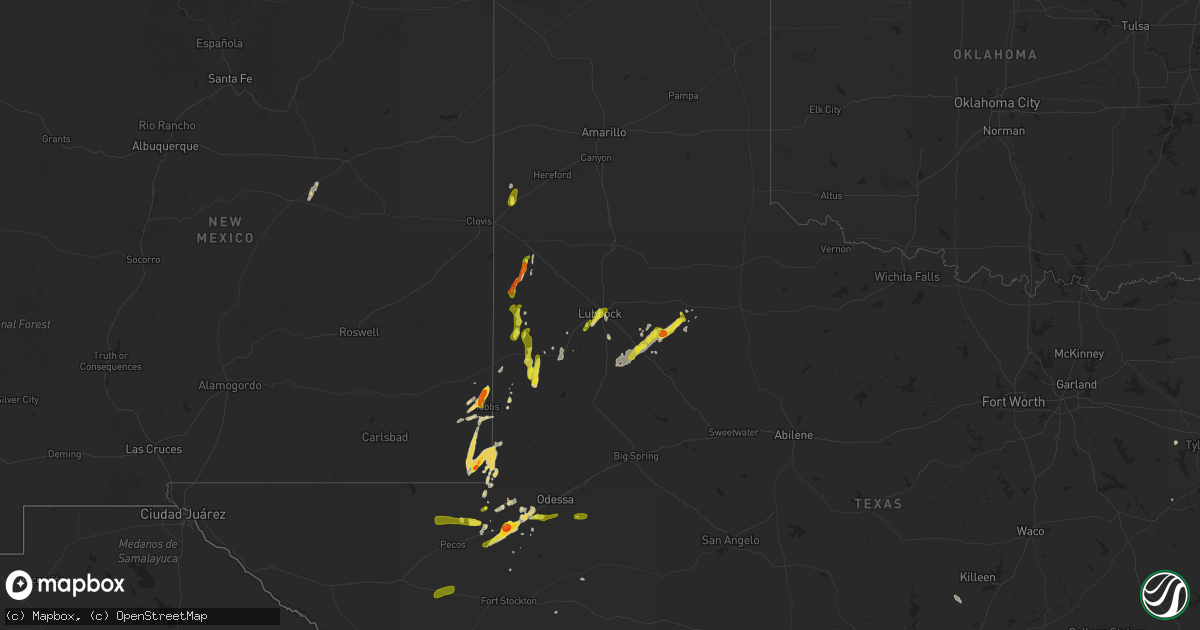
Hail Map on May 14, 2015
Get this storm
May 14 map
$229
one time, instant access
Download today. No call, no setup
Keep the $229
Bought the map and want the full workflow? Apply the entire $229 to a subscription within 7 days. None of it is wasted.
Every map, not just this one
This buys you this map. Subscription and you get every map we run, in the markets you choose from a few cities to whole states to nationwide. Plus real-time alerts the moment a storm fires.
Contact data
Name, contact info, occupancy, even credit band for addresses in the footprint. You go from where it hit to who to call.
Become the source they trust
Unlimited branding weather history reports on demand. You already have the documented answer ready for the property owner, and you are the one who showed up with it.
Property data and RoofTrace estimates
Pull up any address you have got, its value and the exact code rules for that jurisdiction, straight from One Click Code. Then RoofTrace estimates the squares, pitch, and roof value, priced the way you price.
States Impacted by Hail Map on May 14, 2015
Storm reports
Texas
| Date | Description |
|---|---|
| 05/14/20156:35 PM CDT | Several large trees uprooted along 16e west of 155 |
| 05/14/20156:28 PM CDT | Quarter size hail and 4 to 5 inch tree limbs blowing across highway 271 one-half mile south of us 271 and i20 |
| 05/14/20156:00 PM CDT | A local report indicates 1.75 inch wind near MONAHANS |
| 05/14/20155:30 PM CDT | A local report indicates 1.00 inch wind near 1 W SEAGRAVES |
| 05/14/20154:36 PM CDT | Quarter size hail reported |
| 05/14/20153:55 PM CDT | Trees down seven cove subdivision on lake conroe |
| 05/14/20153:50 PM CDT | Two porches torn off and a metal building destroyed in high winds. Shingles also blown off a house. Near blueberry hill rd and fm 1097. Winds were estimated between 60- |
| 05/14/20156:45 AM CDT | Deputy reported thunderstorm wind damage at the woodward area. |
| 05/14/20156:40 AM CDT | 2 barnes destroyed... 3 trees uprooted... Many branches broken. |
| 05/14/20156:29 AM CDT | Nws storm survey confirmed an ef-1 tornado touched down on a private ranch in rural nw lasalle county. Numerous large trees were snapped at their base and several were |
| 05/14/20153:10 AM CDT | Tree down on ramos st. In batesville blocking road. Time estimated from radar. |
| 05/13/20159:25 PM CDT | Estimated 60-70 mph. Just southeast of the intersection of i-20 and fm1788. |
| 05/13/20159:19 PM CDT | Received via spotternetwork. Wind gust as circulation moved overhead. |
| 05/13/20159:16 PM CDT | Hail currently falling 5 sw of kalgary. |
| 05/13/20159:00 PM CDT | Submitted via internet. |
| 05/13/20158:45 PM CDT | Reported via facebook on texas tech campus. |
| 05/13/20158:36 PM CDT | Nickel to quarter size hail reported by public at 34th and indiana. |
| 05/13/20158:12 PM CDT | Tree damage and roof lifted off a shed on west 4th street in post. |
| 05/13/20158:02 PM CDT | Hail just bigger than quarter size. Reported by off duty nws employee. |
| 05/13/20157:55 PM CDT | Reported by west texas mesonet. |
| 05/13/20157:17 PM CDT | Carport damaged by strong wind gust. Relayed by local media. |
New Mexico
| Date | Description |
|---|---|
| 05/14/20155:20 PM CDT | A local report indicates 1.75 inch wind near 1 W HOBBS |
| 05/14/20155:15 PM CDT | A local report indicates 1.00 inch wind near 1 S HOBBS |
| 05/14/20154:14 PM CDT | A local report indicates 1.75 inch wind near JAL |
| 05/14/20154:05 PM CDT | A local report indicates 60 MPH wind near 4 WNW SANTA TERESA |
Nebraska
| Date | Description |
|---|---|
| 05/14/20155:39 AM CDT | Estimated nickle to quarter size hail on west side of town near the rail yard. |
| 05/14/20155:25 AM CDT | Quarter to maybe half dollar size reported from 5th and silver in north platte. |
Missouri
| Date | Description |
|---|---|
| 05/13/20158:17 PM CDT | Two residences in mendon sustained some roof damage with a few trees nearby also sustaining damage. Picture submitted to kabc 17 in columbia missouri show a tornado ass |
| 05/13/20158:17 PM CDT | Two houses in mendon sustained some roof damage with a few trees nearby also sustaining damage. Reported as a tornado. |
Alabama
| Date | Description |
|---|---|
| 05/13/20157:04 PM CDT | Reports of several trees down in the lake harding area. |
Oklahoma
| Date | Description |
|---|---|
| 05/13/20158:03 PM CDT | Quarter size hail at sherriffs office in idabel |
| 05/13/20157:50 PM CDT | Dime to quarter size hail reported in idabel |
Utah
| Date | Description |
|---|---|
| 05/14/20154:00 PM CDT | West granite dpg31 sensor |
| 05/14/20151:50 PM CDT | A local report indicates 62 MPH wind near MILFORD |
| 05/14/20159:40 AM CDT | Sr12 at boulder summit sensor utbld |
| 05/14/20158:23 AM CDT | Bryce canyon raws bycu1 |
Cities Impacted by Hail Map on May 14, 2015
- Goldsmith, TX
- Odessa, TX
- Sylvan Grove, KS
- Sutherland, NE
- Hershey, NE
- Chandler, TX
- Ben Wheeler, TX
- Kanab, UT
- Seminole, TX
- Lovington, NM
- Hobbs, NM
- Brownfield, TX
- Seagraves, TX
- Monahans, TX
- North Platte, NE
- Post, TX
- Winona, TX
- Barstow, TX
- Pecos, TX
- Crane, TX
- Big Wells, TX
- Lubbock, TX
- Batesville, TX
- La Pryor, TX
- Plainville, KS
- Jal, NM
- Sudan, TX
- Spur, TX
- Plains, TX
- Andrews, TX
- Palestine, TX
- Quemado, TX
- Brady, NE
- Muleshoe, TX
- Friona, TX
- Bovina, TX
- Maxwell, NE
- Kermit, TX
- Tyler, TX
- Tipton, KS
- Ellsinore, MO
- Pyote, TX
- Roca, NE
- Martell, NE
- Catharine, KS
- Victoria, KS
- Wilson, TX
- Mentone, TX
- Hays, KS
- Ralls, TX
- Crosbyton, TX
- Justiceburg, TX
- Prairie View, KS
- Logan, KS
- Lorenzo, TX
- Wolfforth, TX
- Table Rock, NE
- Briggs, TX
- Bertram, TX
- Idabel, OK
- Encinal, TX
- Balmorhea, TX
- Enochs, TX
- Whitehouse, TX
- Uvalde, TX
- Whiteface, TX
- Denver City, TX
- Phillipsburg, KS
- Morton, TX
- Crete, NE
- Clatonia, NE
- Hallam, NE
- Long Island, KS
- Grant, NE
- Eunice, NM
- Carrizo Springs, TX
- Crystal City, TX
- Tahoka, TX
- Monument, NM
- Holly, CO
- Vaughn, NM
- Eagle Pass, TX
- Cotulla, TX
- De Kalb, TX
- Broken Bow, OK
- Midland, TX
- Wink, TX
- Ropesville, TX
- Tokio, TX
- Dickens, TX