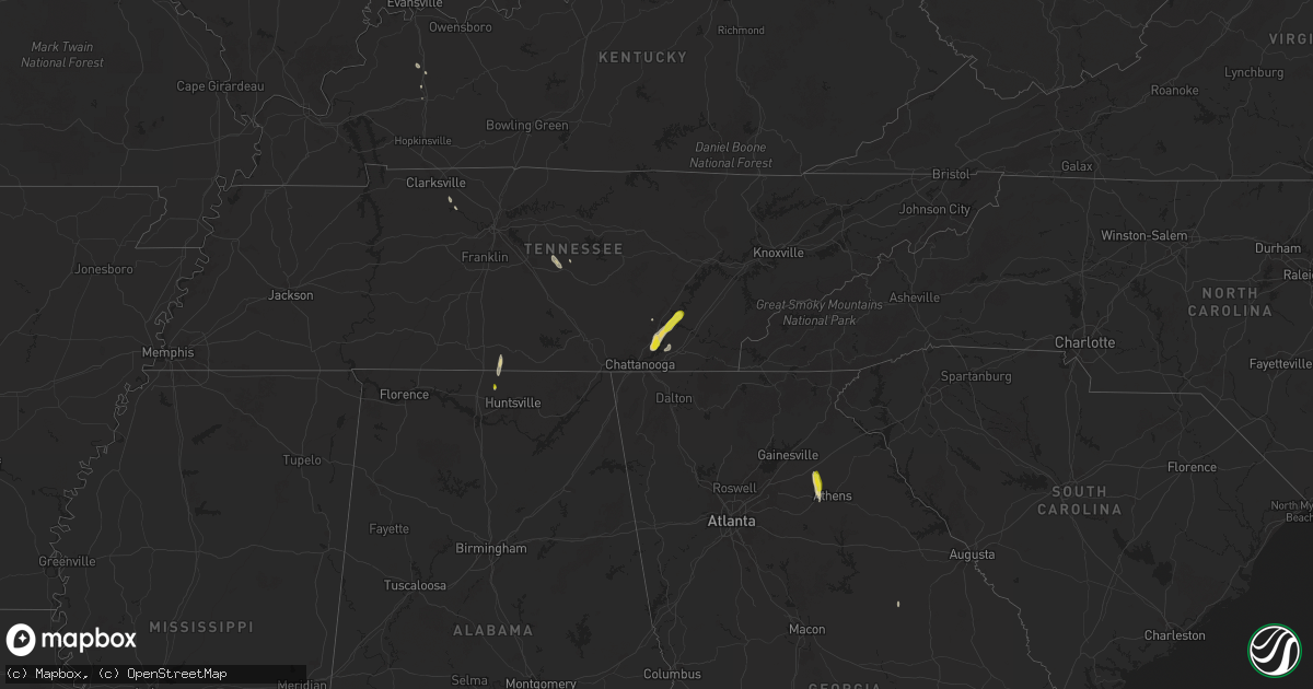
Hail Map on May 12, 2025
Get this storm
May 12 map
$229
one time, instant access
Download today. No call, no setup
Keep the $229
Bought the map and want the full workflow? Apply the entire $229 to a subscription within 7 days. None of it is wasted.
Every map, not just this one
This buys you this map. Subscription and you get every map we run, in the markets you choose from a few cities to whole states to nationwide. Plus real-time alerts the moment a storm fires.
Contact data
Name, contact info, occupancy, even credit band for addresses in the footprint. You go from where it hit to who to call.
Become the source they trust
Unlimited branding weather history reports on demand. You already have the documented answer ready for the property owner, and you are the one who showed up with it.
Property data and RoofTrace estimates
Pull up any address you have got, its value and the exact code rules for that jurisdiction, straight from One Click Code. Then RoofTrace estimates the squares, pitch, and roof value, priced the way you price.
States Impacted by Hail Map on May 12, 2025
Storm reports
North Carolina
| Date | Description |
|---|---|
| 05/12/20254:10 PM CDT | Trees down... Possible tornado damage. |
| 05/12/20254:06 PM CDT | An ef-1 tornado occurred in the southern terrace area of princeville... Nc... Then traveled northward into tarboro. Several large trees were snapped along the way befor |
| 05/12/20252:42 AM CDT | Confirmed with tds. |
| 05/12/20252:40 AM CDT | Structural damage and trees and power lines down at gay st. And school st.... Just upstream of krax-confirmed tornado |
| 05/12/20252:27 AM CDT | Ef-1 tornado was surveyed along route 258... Traveling northward for 2 minutes before dissipating near the intersection of otter creek church rd and wooten rd. |
| 05/11/202511:52 PM CDT | Tree down across the road at the intersection of mercer lane and henderson road. |
Alabama
| Date | Description |
|---|---|
| 05/12/20256:31 PM CDT | A tree was knocked down at riverton rose trail at eagle point drive. Time estimated by radar. |
Georgia
| Date | Description |
|---|---|
| 05/12/20255:48 PM CDT | Tree down across the road near the intersection of jefferson river rd and orrs school rd. |
| 05/12/20255:45 PM CDT | Quarter size hail in the city of jefferson near brockton rd and red tail rd. |
Florida
| Date | Description |
|---|---|
| 05/12/20255:20 PM CDT | Playground equipment knocked down... Chairs blown over... Small trees blown over/uprooted. |
| 05/12/20255:15 PM CDT | Several pictures showing uprooted trees... Torn tree branches... Pieces of a broken fence... And tilted/leaning chain-link fences. Reports coincide with a supercell tha |
| 05/11/20257:15 PM CDT | Trained spotter reported broken tree branches and strewn patio furniture in the canterbury neighborhood in boynton beach. Possible tornado. |
Montana
| Date | Description |
|---|---|
| 05/12/20254:45 PM CDT | Mesonet station ew1931 rudyard. Showers and the front combined to result in a 63 mph gust. |
| 05/11/202510:18 PM CDT | Poplar raws. |
| 05/11/20259:39 PM CDT | Asos station kolf wolf point airport. |
| 05/11/20259:00 PM CDT | Mesonet station mtm87 fort peck s. |
Tennessee
| Date | Description |
|---|---|
| 05/12/20255:12 PM CDT | Time estimated by radar. Dispatch reported many wind damage reports. Online power outage monitoring also indicated around ten percent of the county without power due to |
| 05/12/20254:34 PM CDT | Social media message reporting half dollar sized hail in lakesite tennessee. |
| 05/12/20254:23 PM CDT | Tree down on a home. Time estimated from radar. |
| 05/12/20254:15 PM CDT | 911 call center reported tree down on house. No injuries reported. |
| 05/12/20254:06 PM CDT | Tree down on house reported by 911 call center. No injuries. |
Cities Impacted by Hail Map on May 12, 2025
- Bowdon, GA
- Harvest, AL
- Ardmore, AL
- Toney, AL
- Hixson, TN
- Soddy Daisy, TN
- Taft, TN
- Harrison, TN
- Fayetteville, TN
- Birchwood, TN
- Decatur, TN
- Georgetown, TN
- Ooltewah, TN
- McRae Helena, GA
- Lumber City, GA
- Dayton, TN
- Alamo, GA
- Bogart, GA
- Watkinsville, GA
- Athens, GA
- Liberty, TN
- Statham, GA
- Jefferson, GA
- Woodbury, TN
- Readyville, TN
- Milton, TN
- Clarksville, TN
- Ashland City, TN
- McDonald, TN
- Chapmansboro, TN
- Vidalia, GA
- Madisonville, KY
- Hanson, KY
- Manitou, KY
- Ardmore, TN
- Nortonville, KY
- Pinetops, NC