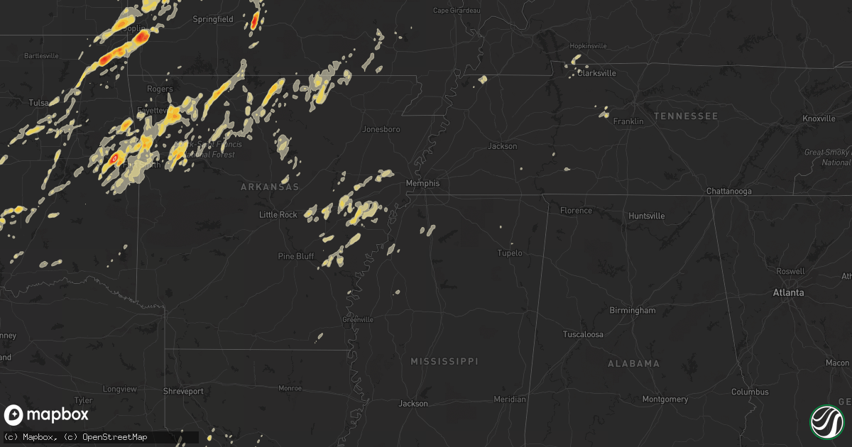
Hail Map on May 12, 2011
Get this storm
May 12 map
$229
one time, instant access
Download today. No call, no setup
Keep the $229
Bought the map and want the full workflow? Apply the entire $229 to a subscription within 7 days. None of it is wasted.
Every map, not just this one
This buys you this map. Subscription and you get every map we run, in the markets you choose from a few cities to whole states to nationwide. Plus real-time alerts the moment a storm fires.
Contact data
Name, contact info, occupancy, even credit band for addresses in the footprint. You go from where it hit to who to call.
Become the source they trust
Unlimited branding weather history reports on demand. You already have the documented answer ready for the property owner, and you are the one who showed up with it.
Property data and RoofTrace estimates
Pull up any address you have got, its value and the exact code rules for that jurisdiction, straight from One Click Code. Then RoofTrace estimates the squares, pitch, and roof value, priced the way you price.
States Impacted by Hail Map on May 12, 2011
Storm reports
Missouri
| Date | Description |
|---|---|
| 05/12/20116:55 PM CDT | A local report indicates 1.00 inch wind near 3 NW NEOSHO |
| 05/12/20116:47 PM CDT | A local report indicates 1.00 inch wind near LOUISBURG |
| 05/12/20116:45 PM CDT | Trees down near newport |
| 05/12/20116:43 PM CDT | Quarter hail in hazelgreen. |
| 05/12/20116:39 PM CDT | A local report indicates 1.75 inch wind near PITTSBURG |
| 05/12/20116:20 PM CDT | Minor siding damage to couple of homes and a couple of trees down. |
| 05/12/20116:20 PM CDT | Softball size hail |
| 05/12/20116:20 PM CDT | Also reported in oakland |
| 05/12/20116:16 PM CDT | A local report indicates 1.75 inch wind near SUNRISE BEACH |
| 05/12/20116:15 PM CDT | Tennis ball hail |
| 05/12/20116:15 PM CDT | A local report indicates 1.00 inch wind near CARL JUNCTION |
| 05/12/20116:14 PM CDT | A local report indicates 1.50 inch wind near 10 NW BOLIVAR |
| 05/12/20116:10 PM CDT | A local report indicates 1.50 inch wind near 9 N BOLIVAR |
| 05/12/20116:10 PM CDT | Also e60 mph winds |
| 05/12/20116:02 PM CDT | A local report indicates 1.25 inch wind near TIFFIN |
| 05/12/20116:00 PM CDT | A local report indicates 1.75 inch wind near 2 N FAIR PLAY |
| 05/12/20115:54 PM CDT | Public report of 1.5 inch hail at mount zion...time of report estimated by radar. |
| 05/12/20115:50 PM CDT | Just southeast of macks creek. |
| 05/12/20115:36 PM CDT | A local report indicates 1.75 inch wind near ARCOLA |
| 05/12/20115:30 PM CDT | A local report indicates 1.75 inch wind near OSCEOLA |
| 05/12/20115:25 PM CDT | A local report indicates 1.00 inch wind near OSCEOLA |
| 05/12/20115:21 PM CDT | A local report indicates 1.00 inch wind near ARCOLA |
| 05/12/20115:20 PM CDT | A local report indicates 2.00 inch wind near 4 ESE SYLVANIA |
| 05/12/20115:10 PM CDT | Baseball hail in cedar gap. Also quarter to half dollar hail reported by public. |
| 05/12/20115:00 PM CDT | A local report indicates 1.00 inch wind near 1 S BEARCREEK |
| 05/12/20114:45 PM CDT | Several large limbs down around town with isolated power outages. |
| 05/12/201112:08 AM CDT | Small trees knocked down. Penny size hail. |
| 05/11/201111:50 PM CDT | Many trees reported blown down south and west of steeelville. Power outages reported from trees falling on power lines in and around steelville. Window broken on a home |
| 05/11/201110:35 PM CDT | Many trees reported blown down south and west of steeelville. Power outages reported from trees falling on power lines in and around steelville. Window broken on a home |
| 05/11/201110:17 PM CDT | A local report indicates 60 MPH wind near ROLLA |
| 05/11/201110:17 PM CDT | A local report indicates 1.00 inch wind near ROLLA |
| 05/11/20119:40 PM CDT | Relayed through tv station ky3 |
| 05/11/20119:35 PM CDT | A couple of downed trees |
| 05/11/20119:14 PM CDT | A local report indicates 60 MPH wind near AVA |
| 05/11/20119:12 PM CDT | A local report indicates 1.00 inch wind near 6 ESE STOUTLAND |
| 05/11/20119:12 PM CDT | 16 inch trees down along highway a in rome...power is out |
| 05/11/20119:11 PM CDT | A local report indicates 60 MPH wind near 1 S LEBANON |
| 05/11/20119:04 PM CDT | A local report indicates 1.00 inch wind near 1 S DECATURVILLE |
| 05/11/20118:56 PM CDT | 100 feet of roofing off of a home |
| 05/11/20118:36 PM CDT | A local report indicates 1.00 inch wind near 3 NE MACON |
| 05/11/20118:34 PM CDT | 60 to 65 mph winds estimated in the eastern side of macon |
| 05/11/20118:31 PM CDT | Power line down near rogers and fremont. |
| 05/11/20118:25 PM CDT | At battlefield and golden |
| 05/11/20118:20 PM CDT | A local report indicates 1.75 inch wind near URBANA |
| 05/11/20117:55 PM CDT | A local report indicates 1.00 inch wind near URBANA |
| 05/11/20117:45 PM CDT | Large sign damaged |
| 05/11/20117:45 PM CDT | A local report indicates 1.00 inch wind near SUNRISE BEACH |
| 05/11/20117:41 PM CDT | Gust to 56 knots... 64 mph. |
| 05/11/20117:39 PM CDT | Jefferson farm and gardens |
| 05/11/20117:25 PM CDT | A local report indicates 1.00 inch wind near 2 W SARCOXIE |
| 05/11/20117:25 PM CDT | A local report indicates 1.75 inch wind near MACKS CREEK |
| 05/11/20117:18 PM CDT | No damage reported. |
| 05/11/20117:16 PM CDT | A local report indicates 1.00 inch wind near 4 W MACKS CREEK |
| 05/11/20117:15 PM CDT | Large tree down north side of california...tree took out power lines. |
| 05/11/20117:14 PM CDT | 8 inch tree limbs blown down in clarksburg |
| 05/11/20117:13 PM CDT | Egg size hail reported in almon. |
| 05/11/20117:05 PM CDT | A local report indicates 2.75 inch wind near 3 SW DIAMOND |
Florida
| Date | Description |
|---|---|
| 05/12/20115:31 PM CDT | Trained spotter reports hail larger than quarters just south of colonial boulevard on six mile cypress parkway. |
| 05/12/20115:25 PM CDT | Trained spotter reports half dollar size hail near the intersection of colonial boulevard and lee boulevard. |
Arkansas
| Date | Description |
|---|---|
| 05/12/20116:56 PM CDT | Downed power lines |
| 05/12/20116:23 PM CDT | A local report indicates 1.75 inch wind near WESLEY |
| 05/12/20116:18 PM CDT | Hailed for 10-15 minutes devil dens state park |
| 05/11/201110:40 PM CDT | Part of a roof was torn off a shop and a small horse barn was blown into a field. |
| 05/11/201110:05 PM CDT | Pieces of a tin roof were torn off a building. Several road signs and one highway sign were bent or damaged. There were also power outages and numerous small to medium |
| 05/11/20119:06 PM CDT | A local report indicates 1.75 inch wind near 1 SE MOUNTAIN HOME |
| 05/11/20119:06 PM CDT | A local report indicates 64 MPH wind near 1 SE MOUNTAIN HOME |
| 05/11/20118:45 PM CDT | Hail covered the ground up to three inches deep. Report relayed via ky3 in springfield. |
| 05/11/20118:36 PM CDT | Golf ball size hail 1 mile north of the harrison airport. |
| 05/11/20118:12 PM CDT | Quarter to half dollar size hail covering the ground...tree tops 4 inches in diameter snapped. |
| 05/11/20118:00 PM CDT | Golf ball size hail 1 mile north of the harrison airport. |
| 05/11/20117:48 PM CDT | A local report indicates 1.75 inch wind near OZARK |
| 05/11/20117:48 PM CDT | Tree down in ozark |
| 05/11/20117:44 PM CDT | A local report indicates 1.00 inch wind near VENDOR |
| 05/11/20117:10 PM CDT | A local report indicates 1.75 inch wind near NATURAL DAM |
Michigan
| Date | Description |
|---|---|
| 05/12/20115:09 PM CDT | A tree was reported down across gun lake rd near s yankee springs rd. |
| 05/12/20115:06 PM CDT | A local report indicates 1.00 inch wind near 4 WSW WAYLAND |
| 05/12/20114:50 PM CDT | A local report indicates 1.00 inch wind near 4 WSW WAYLAND |
| 05/12/20113:55 PM CDT | A local report indicates 1.00 inch wind near 3 S MIDDLEVILLE |
Texas
| Date | Description |
|---|---|
| 05/12/20111:50 PM CDT | Initial report of wind damage near travis middle school in port lavaca. |
| 05/12/201112:30 PM CDT | Trees down |
| 05/12/201112:25 PM CDT | A local report indicates 70 MPH wind near BRENHAM |
| 05/12/201112:00 PM CDT | Some branches broken from trees |
| 05/12/201111:40 AM CDT | Large tree down across hwy121 in town... Many limbs blow down |
| 05/12/201111:40 AM CDT | Large tree limbs down in la grange |
| 05/12/201111:30 AM CDT | Power lines down in the city of bryan. |
| 05/12/201111:20 AM CDT | Trees down on the golf course |
| 05/12/201111:00 AM CDT | A few trees blown down across the bastrop area |
| 05/12/201110:45 AM CDT | Large tree limbs and branches blown down |
| 05/12/201110:30 AM CDT | Some roof damage in down town seguin. |
| 05/12/201110:15 AM CDT | Hail along hwy 2688 |
| 05/12/201110:15 AM CDT | Hail along hwy 2688 |
| 05/12/201110:08 AM CDT | Pea to nickel size hail |
| 05/12/201110:01 AM CDT | Forwarded through ch4 |
| 05/12/201110:00 AM CDT | A local report indicates 1.75 inch wind near 2 NW KIRBY |
| 05/12/20119:45 AM CDT | Multiple trees blown down... Primarily on the west side of town |
| 05/12/20119:45 AM CDT | A local report indicates 1.00 inch wind near HELOTES |
| 05/12/20119:34 AM CDT | Fences blown down 1 mi se of kempner |
| 05/12/20119:32 AM CDT | High thunderstorm winds |
| 05/12/20119:25 AM CDT | Winds est 60 plus mph. Lots of tree damage city wide. |
| 05/12/20119:18 AM CDT | A local report indicates 1.75 inch wind near CARRIZO SPRINGS |
| 05/12/20119:16 AM CDT | Small hail but 2 large mesquite tree limbs snapped off |
| 05/12/20119:15 AM CDT | Damage to small portable building and small utility pole |
| 05/12/20119:15 AM CDT | Quarter to golf ball size hail on us hwy281 |
| 05/12/20119:15 AM CDT | A local report indicates 1.75 inch wind near 3 NNE CARRIZO SPRINGS |
| 05/12/20118:55 AM CDT | A local report indicates 1.00 inch wind near 1 E TANGLEWOOD FOREST |
| 05/12/20118:15 AM CDT | 60-70 mph winds dime to nickel sized hail |
| 05/12/20118:15 AM CDT | Small tree limbs down |
| 05/12/20117:55 AM CDT | Limbs broken from trees brief very heavy rain |
| 05/12/20117:40 AM CDT | Large tree blown onto roof knocking down chimney |
| 05/11/201110:15 PM CDT | Minor tree damages |
Iowa
| Date | Description |
|---|---|
| 05/12/20116:50 PM CDT | Half dollar sized hail and sprinkles of rain reported by spotter driving on highway 20 between galva and holstein. |
| 05/12/20116:39 PM CDT | A local report indicates 1.50 inch wind near 4 SW ANTHON |
| 05/12/20116:35 PM CDT | Golf ball sized hail just starting in oto. Pea sized hail and sprinkles had occurred earlier. |
| 05/12/20116:20 PM CDT | A local report indicates 2.75 inch wind near 3 E ONAWA |
| 05/12/20116:17 PM CDT | A local report indicates 2.75 inch wind near 1 S RODNEY |
| 05/12/20116:10 PM CDT | Baseball sized hail reported to emergency managers office from a location near the intersection of 16th and locust in smithland. |
| 05/12/20116:00 PM CDT | A local report indicates 1.50 inch wind near 4 SW HOLSTEIN |
| 05/12/20115:58 PM CDT | A local report indicates 2.75 inch wind near WHITING |
| 05/12/20115:52 PM CDT | A local report indicates 1.75 inch wind near 1 W WHITING |
| 05/11/201111:35 PM CDT | Pea to quarter size hail in the town of mason city... |
| 05/11/201111:30 PM CDT | Quarter size hail southeast of hampton...time estimated with radar... |
| 05/11/201110:28 PM CDT | Quarter size hail in the town of clarion... |
| 05/11/20118:49 PM CDT | Trained spotter reported quarter size hail west of lake city on hwy 175... |
| 05/11/20118:35 PM CDT | Caseys carry out pizza reported quarter size hail on west side of scranton...time estimated from radar |
| 05/11/20118:27 PM CDT | Nickel to quarter size hailstones.... |
| 05/11/20118:26 PM CDT | Mostly nickels...with a few quarter size hailstones |
| 05/11/20117:55 PM CDT | Mostly dimes and nickels...with a few quarter size hailstones.... |
| 05/11/20117:23 PM CDT | Hail up to the size of quarters covered the ground. |
| 05/11/20117:15 PM CDT | Pea to quarter sized hail covering the ground |
| 05/11/20117:15 PM CDT | A local report indicates 1.00 inch wind near 5 S GALVA |
| 05/11/20117:12 PM CDT | Hail varied from quarters to dimes. |
Tennessee
| Date | Description |
|---|---|
| 05/12/20116:04 PM CDT | A few trees were downed in hermitage. |
| 05/12/20115:52 PM CDT | Trees and power lines...along with damage to a section of a roof of a building...near the intersection of polk avenue and fesslers lane. |
| 05/12/20115:42 PM CDT | A large tree limb fell on a power line in west nashville. |
| 05/12/20115:00 PM CDT | A few trees were blown down in and just east of waynesboro. |
North Carolina
| Date | Description |
|---|---|
| 05/12/20116:15 PM CDT | Observer said that the 1 inch hail started to fall at 715 edt. |
| 05/12/20113:37 PM CDT | Reported at the davidson river campground. |
Kentucky
| Date | Description |
|---|---|
| 05/12/20115:20 PM CDT | Several trees down in the leitchfield and clarkson areas of grayson county. |
Virginia
| Date | Description |
|---|---|
| 05/12/20116:04 PM CDT | A local report indicates 1.00 inch wind near 1 WNW FRIES |
| 05/12/20116:03 PM CDT | A local report indicates 1.00 inch wind near NW FRIES |
| 05/12/20115:34 PM CDT | Lasted 5 minutes and covered the ground along pine brook drive |
| 05/12/20115:17 PM CDT | Hail at least quarter size fell for 20 minutes from 617 until 637 and is covering the ground. |
| 05/12/20115:10 PM CDT | At exit 14 on interstate 77. |
| 05/12/20115:00 PM CDT | A local report indicates 1.00 inch wind near 5 NW HILLSVILLE |
| 05/12/20114:18 PM CDT | Quarter size hail at the interstate 77 exit for hillsville |
| 05/12/20113:59 PM CDT | Quarter size hail was falling near the intersection of highway 52 and rotenizer drive. |
| 05/12/20113:45 PM CDT | A local report indicates 1.00 inch wind near BLACKSBURG |
| 05/12/20112:48 PM CDT | Round hailstone clusters 2.25 inches in diameter with some spikey looking hail 4 inches long. Dented top of pickup truck. |
| 05/12/201112:11 PM CDT | Reports of quarter size hail throughout the city |
Ohio
| Date | Description |
|---|---|
| 05/12/20116:20 PM CDT | A local report indicates 58 MPH wind near STEUBENVILLE |
| 05/12/20115:05 PM CDT | Two trees down near greenford. |
| 05/12/20114:15 PM CDT | Two trees down. |
| 05/12/20114:05 PM CDT | A local report indicates 1.00 inch wind near 2 S MEDINA |
| 05/12/20114:00 PM CDT | A local report indicates 1.00 inch wind near CLEVELAND |
| 05/12/20113:36 PM CDT | A local report indicates 1.00 inch wind near WARREN |
| 05/12/20113:35 PM CDT | A local report indicates 1.75 inch wind near MIDDLEFIELD |
| 05/12/20113:35 PM CDT | A few trees snapped off and partial damage to several roofs in valley city. |
| 05/12/20113:30 PM CDT | Estimated 60 to 70 mph winds. |
| 05/12/20113:05 PM CDT | A local report indicates 1.00 inch wind near CUYAHOGA FALLS |
| 05/12/20113:05 PM CDT | A local report indicates 1.00 inch wind near ASHLAND |
| 05/12/20113:00 PM CDT | A local report indicates 1.00 inch wind near 2 S NORWALK |
| 05/12/20112:57 PM CDT | A local report indicates 1.00 inch wind near ASHLAND |
| 05/12/20112:51 PM CDT | A local report indicates 1.75 inch wind near 4 S MIDDLEFIELD |
| 05/12/20112:50 PM CDT | A local report indicates 1.25 inch wind near CHARDON |
| 05/12/20112:44 PM CDT | A local report indicates 1.25 inch wind near CHARDON |
| 05/12/20119:41 AM CDT | A local report indicates 1.75 inch wind near OLD WASHINGTON |
| 05/12/20117:27 AM CDT | Event occurred between 812 am 05 12 2011 and 827 am 05 12 2011 |
West Virginia
| Date | Description |
|---|---|
| 05/12/20113:39 PM CDT | A local report indicates 1.00 inch wind near 1 ENE BUCK |
| 05/12/20113:15 PM CDT | Quarter size hail near forest hill |
| 05/12/20112:19 PM CDT | Quarter size hail on minnie dunn road |
| 05/12/20111:49 PM CDT | A local report indicates 1.00 inch wind near RUPERT |
| 05/12/201112:55 PM CDT | A local report indicates 1.75 inch wind near 2 NNE BIRCH RIVER |
| 05/12/201112:35 PM CDT | A local report indicates 1.75 inch wind near 2 NNE BIRCH RIVER |
| 05/12/201112:30 PM CDT | A local report indicates 1.50 inch wind near 2 E CHLOE |
| 05/12/201112:00 PM CDT | A local report indicates 1.00 inch wind near MOUNT ZION |
| 05/12/201112:00 PM CDT | A local report indicates 1.00 inch wind near GRANTSVILLE |
Oklahoma
| Date | Description |
|---|---|
| 05/12/20116:55 PM CDT | A local report indicates 1.00 inch wind near 8 S COWETA |
| 05/12/20116:50 PM CDT | Tree blown down across highway 3 |
| 05/12/20116:45 PM CDT | The hail was reported a half of a mile west of highways 9 and 99. |
| 05/12/20116:30 PM CDT | A local report indicates 1.00 inch wind near LEONARD |
| 05/12/20116:26 PM CDT | A local report indicates 2.00 inch wind near WYANDOTTE |
| 05/12/20116:13 PM CDT | A local report indicates 2.00 inch wind near SALLISAW |
| 05/12/20116:11 PM CDT | Hail was measured and photo was sent to kfsm |
| 05/12/20116:10 PM CDT | Lasted for about 7 minutes. Damaged windshields. |
| 05/12/20116:07 PM CDT | Broken windshields |
| 05/12/20116:05 PM CDT | A local report indicates 1.25 inch wind near 2 ESE SALLISAW |
| 05/12/20116:05 PM CDT | A local report indicates 1.75 inch wind near FAIRLAND |
| 05/12/20116:02 PM CDT | A local report indicates 1.50 inch wind near SALLISAW |
| 05/12/20116:01 PM CDT | A local report indicates 1.00 inch wind near 2 S MOUNDS |
| 05/12/20115:59 PM CDT | A local report indicates 1.25 inch wind near 5 NE PAULS VALLEY |
| 05/12/20115:58 PM CDT | A local report indicates 1.00 inch wind near SALLISAW |
| 05/12/20115:56 PM CDT | Golfball and tennis ball size hail broke windshields |
| 05/12/20115:55 PM CDT | A local report indicates 1.75 inch wind near 1 SE AFTON |
| 05/12/20115:53 PM CDT | A local report indicates 1.75 inch wind near 1 N STILWELL |
| 05/12/20115:44 PM CDT | A local report indicates 1.00 inch wind near BYARS |
| 05/12/20115:40 PM CDT | The report was relayed by weather affirmation. |
| 05/12/20115:36 PM CDT | A local report indicates 1.00 inch wind near PRAGUE |
| 05/12/20115:35 PM CDT | The hail was reported at the intersection of hwys 3e and 99a. |
| 05/12/20115:30 PM CDT | Very heavy rain...some hail to quarter size...and gusty winds for a brief time at the koa campground near pierce. |
| 05/12/20115:27 PM CDT | A local report indicates 1.00 inch wind near BIG CABIN |
| 05/12/20115:19 PM CDT | At intersection of hwy 3 and rock creek rd |
| 05/12/20115:10 PM CDT | A local report indicates 1.00 inch wind near 4 N WELCH |
| 05/12/20115:00 PM CDT | A local report indicates 1.00 inch wind near HANNA |
| 05/12/20115:00 PM CDT | A local report indicates 1.25 inch wind near 5 NW PRYOR |
| 05/12/20111:18 AM CDT | At intersection of hwy 3 and rock creek rd |
| 05/11/20118:20 PM CDT | A local report indicates 1.00 inch wind near ASHLAND |
| 05/11/20117:43 PM CDT | A local report indicates 1.25 inch wind near 2 N STONEWALL |
| 05/11/20117:32 PM CDT | A local report indicates 1.50 inch wind near GERTY |
| 05/11/20117:13 PM CDT | A local report indicates 70 MPH wind near SPIRO |
Illinois
| Date | Description |
|---|---|
| 05/12/20115:35 PM CDT | Two 10 inch diameter trees blocking broadway street...1/2 miles from keystone road. |
| 05/12/20115:20 PM CDT | School zone sign down by thunderstorm winds. Price rd and rt 47 |
| 05/12/20115:15 PM CDT | Horizontal rain and small tree branches down. |
| 05/12/20115:06 PM CDT | Intersection of nelson and heartland |
Wisconsin
| Date | Description |
|---|---|
| 05/12/20115:26 PM CDT | A local report indicates 1.75 inch wind near GREENVILLE |
| 05/12/20115:21 PM CDT | Tree limbs down. 1/4 inch hail. |
| 05/12/20115:07 PM CDT | A local report indicates 1.00 inch wind near ROTHSCHILD |
| 05/12/20115:00 PM CDT | A local report indicates 1.00 inch wind near SCHOFIELD |
| 05/12/20114:59 PM CDT | Penny to quarter size hail. |
Kansas
| Date | Description |
|---|---|
| 05/12/20116:00 PM CDT | A local report indicates 1.75 inch wind near RIVERTON |
| 05/12/20115:53 PM CDT | Trained spotter near state line also reporting e58 mph winds and a funnel cloud. |
| 05/12/20114:45 PM CDT | A local report indicates 1.75 inch wind near FRANKLIN |
Nebraska
| Date | Description |
|---|---|
| 05/12/20116:55 PM CDT | Pea to quarter size hail. |
| 05/12/20116:35 PM CDT | Near 48th and highway 2. |
| 05/12/20116:32 PM CDT | Near 40th and old cheney. |
| 05/12/20116:30 PM CDT | Quarter to golfball hail for fifteen minutes from 630 to 645 pm cdt. |
| 05/12/20116:25 PM CDT | 70th and pioneers |
| 05/12/20116:25 PM CDT | A local report indicates 1.00 inch wind near 7 NW FAIRBURY |
| 05/12/20116:08 PM CDT | Pea to quarter sized hail covered the ground. |
| 05/12/20115:37 PM CDT | Dime to quarter size hail. |
| 05/12/20115:20 PM CDT | Ground is white. |
| 05/12/20115:19 PM CDT | A local report indicates 1.00 inch wind near ST. LIBORY |
| 05/12/20115:15 PM CDT | Hail lasted 20 minutes. |
| 05/12/20114:57 PM CDT | Trained spotter reported small rope tornado. |
| 05/12/20114:55 PM CDT | A local report indicates 1.00 inch wind near RAVENNA |
| 05/12/20114:52 PM CDT | A local report indicates 1.00 inch wind near RAVENNA |
| 05/12/20114:52 PM CDT | A local report indicates a tornado near 2 N BRADSHAW |
| 05/12/20114:50 PM CDT | A local report indicates a tornado near 8 S AURORA |
| 05/12/20114:32 PM CDT | A local report indicates 1.50 inch wind near 6 S ROCKVILLE |
| 05/12/20114:28 PM CDT | A local report indicates 1.00 inch wind near 2 SW ROCKVILLE |
| 05/12/20114:10 PM CDT | A local report indicates 1.25 inch wind near 4 SW BENEDICT |
| 05/12/20114:07 PM CDT | A local report indicates 1.00 inch wind near 6 WSW ROCKVILLE |
| 05/12/20114:05 PM CDT | A local report indicates a tornado near 3 NE RAVENNA |
| 05/11/201110:17 PM CDT | Near 107th and ida streets far northwest omaha. |
| 05/11/201110:05 PM CDT | A local report indicates 1.00 inch wind near 2 NE GRETNA |
| 05/11/20119:08 PM CDT | Dime to quarter size |
| 05/11/20118:50 PM CDT | Est 60 mph...2-3 inch tree branch down |
| 05/11/20118:42 PM CDT | A local report indicates 1.00 inch wind near WYMORE |
| 05/11/20118:40 PM CDT | A local report indicates 1.25 inch wind near BLUE SPRINGS |
| 05/11/20118:31 PM CDT | A local report indicates 1.25 inch wind near WYMORE |
| 05/11/20118:12 PM CDT | A local report indicates 1.00 inch wind near SURPRISE |
| 05/11/20118:06 PM CDT | A local report indicates 1.75 inch wind near SEWARD |
| 05/11/20118:04 PM CDT | A local report indicates 1.00 inch wind near SEWARD |
| 05/11/20117:56 PM CDT | A local report indicates 1.00 inch wind near COLUMBUS |
| 05/11/20117:53 PM CDT | Quarter size hail covering the ground. |
| 05/11/20117:50 PM CDT | A local report indicates 1.00 inch wind near DAVEY |
| 05/11/20117:44 PM CDT | A local report indicates 1.50 inch wind near 3 E BRADSHAW |
| 05/11/20117:35 PM CDT | A local report indicates 1.50 inch wind near 1 NW EXETER |
| 05/11/20117:35 PM CDT | Fillmore county emergency manager reporting 3 inch hail one half mile south of exeter. |
| 05/11/20117:30 PM CDT | A local report indicates 1.00 inch wind near WYMORE |
| 05/11/20117:30 PM CDT | A local report indicates 1.50 inch wind near 2 N FAIRMONT |
| 05/11/20117:30 PM CDT | Dime to quarter size hail. |
| 05/11/20117:12 PM CDT | A local report indicates 1.00 inch wind near FAIRMONT |
| 05/11/20117:04 PM CDT | A local report indicates 1.00 inch wind near 3 S TOBIAS |
Cities Impacted by Hail Map on May 12, 2011
- Udell, IA
- Unionville, IA
- Port Washington, OH
- Newcomerstown, OH
- Coshocton, OH
- West Lafayette, OH
- Kimbolton, OH
- Beattie, KS
- Quinwood, WV
- Monroeville, OH
- Calvin, OK
- Allen, OK
- Middlefield, OH
- Novelty, OH
- Newbury, OH
- Chesterland, OH
- Chagrin Falls, OH
- Stilwell, OK
- Ashland, OH
- Half Way, MO
- Bolivar, MO
- Horseshoe Bend, AR
- San Antonio, TX
- Helotes, TX
- Lindside, WV
- Union, WV
- Ripplemead, VA
- Newport, VA
- Waiteville, WV
- New Castle, VA
- Greenville, WV
- Pembroke, VA
- Versailles, MO
- Flippin, AR
- Mountain Home, AR
- Marshall, AR
- Clifton Forge, VA
- Tulsa, OK
- Harrison, AR
- Alpena, AR
- Omaha, AR
- Mullin, TX
- Williamsville, MO
- Kyle, TX
- Rockdale, TX
- Anthon, IA
- Glidden, IA
- Monroe, NE
- Jefferson, PA
- Waynesburg, PA
- Carmichaels, PA
- Earlsboro, OK
- Asher, OK
- Maud, OK
- Seminole, OK
- Alvord, TX
- Hallettsville, TX
- Yoakum, TX
- Shiner, TX
- Lebanon, MO
- Porter, OK
- Vian, OK
- Uvalde, TX
- Lake City, MI
- Manton, MI
- North Jackson, OH
- Canfield, OH
- Doniphan, MO
- Grandin, MO
- Olean, MO
- Eldon, MO
- Stonewall, OK
- Shawnee, OK
- Seymour, MO
- Stuttgart, AR
- Ozark, AR
- Spiro, OK
- Alma, AR
- Stigler, OK
- West Fork, AR
- Winslow, AR
- Gans, OK
- Rudy, AR
- Cameron, OK
- Hackett, AR
- Natural Dam, AR
- Bokoshe, OK
- Uniontown, AR
- Keota, OK
- Wister, OK
- Mountainburg, AR
- Cedarville, AR
- Fort Smith, AR
- Van Buren, AR
- Chester, AR
- Arkoma, OK
- Muldrow, OK
- Roland, OK
- Shady Point, OK
- Pocola, OK
- Mccurtain, OK
- Sallisaw, OK
- Wausau, WI
- Austinville, VA
- Hillsville, VA
- Woodlawn, VA
- Mounds, OK
- Beggs, OK
- Iola, WI
- Scandinavia, WI
- Ogdensburg, WI
- Osceola, MO
- Columbia Station, OH
- Valley City, OH
- Litchfield, OH
- Strongsville, OH
- Medina, OH
- Brunswick, OH
- Grafton, OH
- Schell City, MO
- Rockville, MO
- Mansfield, LA
- Converse, LA
- Shelbyville, TX
- Evant, TX
- Goldthwaite, TX
- Galva, IA
- Battle Creek, IA
- Danbury, IA
- Arthur, IA
- Schaller, IA
- Ida Grove, IA
- Gentryville, IN
- Nemaha, IA
- Sac City, IA
- Springdale, AR
- Morris, OK
- Coweta, OK
- Taft, OK
- Boynton, OK
- Oktaha, OK
- Haskell, OK
- Muskogee, OK
- Okmulgee, OK
- Wagoner, OK
- Arlington, NE
- Valley, NE
- Lamar, MO
- Golden City, MO
- Sheldon, MO
- Jerico Springs, MO
- Lockwood, MO
- Jasper, MO
- Appleton City, MO
- Carthage, MO
- El Dorado Springs, MO
- Yutan, NE
- Ithaca, NE
- Ashland, NE
- Stoutland, MO
- Warsaw, MO
- Edwards, MO
- Immokalee, FL
- Gore, OK
- Sutton, WV
- Little Birch, WV
- Gassaway, WV
- Frametown, WV
- Birch River, WV
- Cowen, WV
- Cadillac, MI
- Polk, NE
- Gravois Mills, MO
- Swaledale, IA
- Thornton, IA
- Clear Lake, IA
- Goodell, IA
- Rockwell, IA
- Mason City, IA
- Nora Springs, IA
- Meservey, IA
- Adkins, TX
- Mount Judea, AR
- Mill Creek, OK
- Sulphur, OK
- Robeline, LA
- Gustine, TX
- Dublin, TX
- Fortuna, MO
- Florence, MO
- Sunrise Beach, MO
- Camdenton, MO
- Neosho, MO
- Claremore, OK
- Quapaw, OK
- Big Cabin, OK
- Miami, OK
- Vinita, OK
- Wyandotte, OK
- Seneca, MO
- Pryor, OK
- Afton, OK
- Diamond, MO
- Fairland, OK
- Granby, MO
- Adair, OK
- Joplin, MO
- Roff, OK
- White Bluff, TN
- Zephyr, TX
- Grand Island, NE
- Carrollton, OH
- Alton, MO
- Jay, OK
- Ketchum, OK
- Oxford, WI
- Bland, MO
- Owensville, MO
- Saint James, MO
- Cuba, MO
- Ozone, AR
- Clarksville, AR
- Mcalester, OK
- Hanna, OK
- Austin, TX
- Fairview, TN
- Bon Aqua, TN
- Burns, TN
- Checotah, OK
- Council Hill, OK
- Newell, IA
- Washington, PA
- Stover, MO
- Dunnegan, MO
- Humansville, MO
- Hastings, MI
- Middleville, MI
- Freeport, MI
- Hebron, IL
- Chardon, OH
- West Farmington, OH
- Bristolville, OH
- North Fairfield, OH
- Kempner, TX
- Schulenburg, TX
- Weimar, TX
- Cadiz, OH
- Quincy, MO
- Collins, MO
- Windyville, MO
- Coushatta, LA
- Brackettville, TX
- Pittsburg, MO
- Polk, MO
- Hermitage, MO
- Grovespring, MO
- Hartville, MO
- Clinton, MO
- Galax, VA
- Jacksonburg, WV
- Reader, WV
- Wynne, AR
- Parkin, AR
- Tow, TX
- Lampasas, TX
- San Saba, TX
- Burnet, TX
- Bluffton, TX
- Dixon, MO
- Rolla, MO
- Vichy, MO
- Vienna, MO
- Milligan, NE
- Exeter, NE
- Fairmont, NE
- Linn Creek, MO
- Lake Ozark, MO
- Osage Beach, MO
- Weyauwega, WI
- Waupaca, WI
- Fresno, OH
- Dripping Springs, TX
- Bulverde, TX
- Columbus, NE
- Provencal, LA
- Leesville, LA
- Natchitoches, LA
- Natchez, LA
- Newton Falls, OH
- Southington, OH
- Garrettsville, OH
- Windham, OH
- Carl Junction, MO
- Baxter Springs, KS
- Chetopa, KS
- Riverton, KS
- Pittsburg, KS
- Columbus, KS
- Webb City, MO
- Galena, KS
- Asbury, MO
- Delton, MI
- Plainwell, MI
- Shelbyville, MI
- Wayland, MI
- Blencoe, IA
- Onawa, IA
- Stephenville, TX
- Chippewa Lake, OH
- Seville, OH
- Ledbetter, TX
- Giddings, TX
- Clarksburg, OH
- Williamsport, OH
- Mio, MI
- Fairview, MI
- De Witt, AR
- Myrtle, MO
- Brinkley, AR
- Cotton Plant, AR
- Holly Grove, AR
- Whiting, IA
- Hornick, IA
- Hunt, TX
- Lead Hill, AR
- Compton, AR
- Green Forest, AR
- Ponca, AR
- Henderson, AR
- Gamaliel, AR
- Appleton, WI
- Greenville, WI
- Saint Libory, NE
- Cairo, NE
- Dannebrog, NE
- Chapman, NE
- Osceola, NE
- Schofield, WI
- Aniwa, WI
- Ringle, WI
- Vienna, OH
- Warren, OH
- Eddyville, IA
- Koshkonong, MO
- Salem, AR
- Evening Shade, AR
- Franklin, AR
- Couch, MO
- Thayer, MO
- Glencoe, AR
- Mammoth Spring, AR
- Violet Hill, AR
- Camp, AR
- Wiseman, AR
- Oxford, AR
- Hardy, AR
- Sage, AR
- Cherokee Village, AR
- Ash Flat, AR
- Wimberley, TX
- Round Mountain, TX
- Johnson City, TX
- Riviera, TX
- East Rochester, OH
- Mechanicstown, OH
- Minerva, OH
- Saint Joe, AR
- Holstein, IA
- Memphis, NE
- Waverly, NE
- Ceresco, NE
- Mead, NE
- Wahoo, NE
- Altus, AR
- Fort Myers, FL
- Old Washington, OH
- Cambridge, OH
- Lore City, OH
- Salesville, OH
- Marvell, AR
- Saint Charles, AR
- Clarendon, AR
- Forestburg, TX
- Broaddus, TX
- Somerset, TX
- Von Ormy, TX
- Glennie, MI
- Sarcoxie, MO
- Greenfield, MO
- Fort Dodge, IA
- Garland, NE
- Burton, OH
- Carrizo Springs, TX
- Arcola, MO
- Stockton, MO
- Geneva, NE
- Wanette, OK
- Hartshorne, OK
- Blanco, OK
- Pittsburg, OK
- Umatilla, FL
- Falls City, TX
- Hobson, TX
- Cole Camp, MO
- Lincoln, MO
- Looneyville, WV
- Eagle Pass, TX
- Bradshaw, NE
- Norwalk, OH
- Bellevue, OH
- Montrose, AR
- Hamburg, AR
- Naples, FL
- Lincoln, NE
- Ravenna, NE
- Hazard, NE
- Rockville, NE
- Omaha, NE
- Bennington, NE
- Kennard, NE
- Washington, NE
- Armstrong, TX
- Crocker, MO
- Smithland, IA
- Rodney, IA
- Bunch, OK
- Cookson, OK
- D Hanis, TX
- Hondo, TX
- Woodstock, IL
- Harvard, IL
- Circleville, OH
- Laurelville, OH
- Laredo, TX
- Staplehurst, NE
- York, NE
- Wautoma, WI
- Neshkoro, WI
- Washingtonville, OH
- Salem, OH
- Leetonia, OH
- Macks Creek, MO
- Dadeville, MO
- Aldrich, MO
- Urbana, MO
- Roach, MO
- Kaiser, MO
- Rocky Mount, MO
- Barnett, MO
- Eldridge, MO
- Flemington, MO
- Preston, MO
- Tunas, MO
- Fair Play, MO
- Climax Springs, MO
- La Fayette, KY
- Herndon, KY
- Stratford, OK
- Pauls Valley, OK
- Jacksboro, TX
- Tecumseh, OK
- Gillett, AR
- Tichnor, AR
- Perrin, TX
- Bridgeport, TX
- Cleveland, OH
- Wesley, AR
- Elkins, AR
- Wappapello, MO
- Batesville, TX
- Stuart, OK
- Broken Arrow, OK
- Lehigh, IA
- Dayton, IA
- Cecil, AR
- Arma, KS
- Franklin, KS
- Jbsa Lackland, TX
- Jbsa Ft Sam Houston, TX
- Pennsboro, WV
- Mulberry, KS
- Arcadia, KS
- Girard, KS
- Liberal, MO
- Bronaugh, MO
- Tobias, NE
- Blue Springs, NE
- Wymore, NE
- Bremen, KS
- Beatrice, NE
- Odell, NE
- Waterloo, NE
- Steelville, MO
- Grantsville, WV
- Arnoldsburg, WV
- Crystal City, TX
- Wilson, OK
- Overbrook, OK
- Dow City, IA
- Dunlap, IA
- Winigan, MO
- Bixby, OK
- Menasha, WI
- Troy, WV
- Linn, WV
- Coxs Mills, WV
- Burnsville, WV
- Glenville, WV
- Sand Fork, WV
- Endeavor, WI
- Irons, MI
- Wellston, MI
- Bear Creek, WI
- Manawa, WI
- Amherst, WI
- Inez, TX
- Byron Center, MI
- Byars, OK
- Huntsburg, OH
- Republic, OH
- Carlton, TX
- Vickery, OH
- Clyde, OH
- La Russell, MO
- Miller, MO
- South Greenfield, MO
- Jeromesville, OH
- Waynesboro, TN
- Bennington, OK
- Boswell, OK
- Atoka, OK
- Ava, MO
- Mulberry, AR
- Charleston, AR
- Branch, AR
- Ratcliff, AR
- Coal Hill, AR
- Thompson, OH
- Hindsville, AR
- Huntsville, AR
- Fayetteville, AR
- Mansfield, MO
- Wauseon, OH
- Colt, AR
- Earle, AR
- Lincoln, AR
- Deepwater, MO
- Shiocton, WI
- Squires, MO
- Soper, OK
- Clarks, NE
- Hazen, AR
- Bristow, OK
- Marianna, AR
- Castana, IA
- Seward, NE
- Eagle, NE
- New Milton, WV
- Lockhart, TX
- Maxwell, TX
- Sarita, TX
- Walkersville, WV
- Hacker Valley, WV
- Ireland, WV
- Napier, WV
- Richfield, OH
- Akron, OH
- Peninsula, OH
- Saint Paul, AR
- Barling, AR
- Dyer, AR
- Poteau, OK
- Kingston, AR
- Pettigrew, AR
- Lavaca, AR
- Combs, AR
- Prairie Grove, AR
- Greenwood, AR
- Witter, AR
- Berryville, AR
- Cadiz, KY
- Marble Falls, TX
- Sullivan, OH
- Miami, FL
- Union City, TN
- Valley Springs, AR
- Summit, AR
- Yellville, AR
- Westfield, WI
- Kellyville, OK
- Castle, OK
- Sapulpa, OK
- Fredericksburg, TX
- Victoria, TX
- Adena, OH
- New London, WI
- Fremont, WI
- Hortonville, WI
- Willard, OH
- Stromsburg, NE
- Shelby, NE
- Rose Hill, IA
- What Cheer, IA
- Uhrichsville, OH
- Decaturville, TN
- Bath Springs, TN
- Bloomingdale, OH
- Rayland, OH
- Dillonvale, OH
- Orlando, WV
- Richards, MO
- Rich Hill, MO
- Carlisle, AR
- Lonoke, AR
- Temple, TX
- Bandera, TX
- Pipe Creek, TX
- Belmond, IA
- Russellville, MO
- Lohman, MO
- Weaubleau, MO
- Marshfield, MO
- Augusta, AR
- Ada, OK
- Arcadia, FL
- Del Rio, TX
- Viola, AR
- Caldwell, TX
- Geneva, IA
- Ripon, WI
- Malcolm, NE
- Raymond, NE
- Pleasant Dale, NE
- Bedford, OH
- Brecksville, OH
- Northfield, OH
- Independence, OH
- Farmdale, OH
- Hiwassee, VA
- Dugspur, VA
- Campti, LA
- Kerrville, TX
- Leslie, AR
- Lodi, OH
- Spencer, OH
- Homerville, OH
- Diller, NE
- Caddo, OK
- Asherton, TX
- Everton, AR
- Paoli, OK
- Steele City, NE
- Orwell, OH
- Windsor, OH
- Rising City, NE
- Silver Creek, NE
- Ulysses, NE
- Benedict, NE
- Daykin, NE
- Gresham, NE
- Central City, NE
- Waco, NE
- Utica, NE
- Marquette, NE
- Dwight, NE
- Hampton, NE
- Denton, NE
- Ohiowa, NE
- Hordville, NE
- McCool Junction, NE
- Milford, NE
- Henderson, NE
- Surprise, NE
- Cowgill, MO
- Polo, MO
- Cross Timbers, MO
- Spicewood, TX
- Bennet, NE
- Walton, NE
- Jefferson, IA
- Lohrville, IA
- Farnhamville, IA
- Scranton, IA
- Churdan, IA
- Sloan, IA
- Davey, NE
- Elkhorn, NE
- Valparaiso, NE
- Gretna, NE
- Greenwood, NE
- College Station, TX
- Oxly, MO
- De Valls Bluff, AR
- Biscoe, AR
- Grinnell, IA
- Searsboro, IA
- Webbers Falls, OK
- Porum, OK
- Newburg, MO
- Belle, MO
- Aubrey, AR
- Moro, AR
- Flushing, OH
- Caney, OK
- Coleman, OK
- Kenefic, OK
- Dundee, OH
- Fredericksburg, OH
- Millersburg, OH
- Richland, MO
- Louisburg, MO
- Butler, MO
- Hulbert, OK
- Hilbert, WI
- Fife Lake, MI
- Middlebourne, WV
- Friendly, WV
- Weir, KS
- Pocahontas, AR
- Sycamore, OH
- Lisbon, OH
- Minter City, MS
- Ruleville, MS
- Martell, NE
- Washington, KS
- Waterford, OH
- Pelsor, AR
- Dover, AR
- Witts Springs, AR
- Hartman, AR
- Karnes City, TX
- Amsterdam, OH
- Bergholz, OH
- Marysville, KS
- Buffalo, MO
- Davis, OK
- Sherwood, WI
- Tipton, MO
- Syracuse, MO
- Big Wells, TX
- Somerville, TX
- Gonzales, TX
- Denison, IA
- Arion, IA
- Craigsville, WV
- Camden On Gauley, WV
- Tioga, WV
- Painesville, OH
- Mentor, OH
- Clarksburg, MO
- Latham, MO
- Edgemont, AR
- Pine Grove, WV
- Montreal, MO
- Sabinal, TX
- Medina, TX
- Hillsdale, MI
- Osseo, MI
- Mapleton, IA
- Decatur, NE
- Correctionville, IA
- Oto, IA
- Macy, NE
- Coon Rapids, IA
- Inola, OK
- Forest Hill, WV
- Hinton, WV
- Grayling, MI
- Roscommon, MI
- Oscoda, MI
- Sunset, TX
- Kingston, OH
- Rome, OH
- Calico Rock, AR
- Dolph, AR
- Elizabeth, AR
- Norfork, AR
- Marshfield, WI
- Piedmont, MO
- Ellsinore, MO
- Mill Spring, MO
- Tupelo, OK
- Wynnewood, OK
- Quemado, TX
- Marion, OH
- Fairbury, NE
- Bertram, TX
- Cotulla, TX
- Iberia, MO
- Catoosa, OK
- Spencer, WV
- Rosedale, WV
- Shock, WV
- Creston, WV
- Chloe, WV
- Millstone, WV
- Orma, WV
- Mount Zion, WV
- Milan, OH
- Huron, OH
- Berlin Heights, OH
- Freeport, OH
- Piedmont, OH
- Chelsea, MI
- West Salem, OH
- Polk, OH
- Boley, OK
- Okemah, OK
- Paden, OK
- Fox, AR
- Shirley, AR
- Johannesburg, MI
- Almyra, AR
- Humphrey, AR
- Groveland, FL
- Enola, AR
- Mount Vernon, AR
- Vilonia, AR
- McBain, MI
- New Martinsville, WV
- Homestead, FL
- Westville, OK
- Holly Springs, NC
- Fuquay Varina, NC
- Higden, AR
- Fairfield Bay, AR
- Western, NE
- Gatesville, TX
- Copperas Cove, TX
- Lowry City, MO
- Calhoun, MO
- Antlers, OK
- New Concord, OH
- Norwich, OH
- Onia, AR
- Dime Box, TX
- La Grange, TX
- Max Meadows, VA
- Uniontown, OH
- Wrightsboro, TX
- Smiley, TX
- Tunnelton, WV
- Rowlesburg, WV
- Bunceton, MO
- Prairie Home, MO
- Jamestown, MO
- California, MO
- Quinton, OK
- Eufaula, OK
- Des Arc, AR
- Senatobia, MS
- Como, MS
- Llano, TX
- Kingsland, TX
- Buchanan Dam, TX
- New Sharon, IA
- Boonville, MO
- Rockwell City, IA
- Platte Center, NE
- Boerne, TX
- Welch, OK
- Youngstown, OH
- Ravenna, OH
- Prosperity, PA
- Cushing, IA
- Lott, TX
- Flatwoods, WV
- Sandstone, WV
- Alderson, WV
- Comanche, TX
- Hampton, IA
- Baltic, OH
- Roca, NE
- Bexar, AR
- Geneva, OH
- Rock Creek, OH
- Prim, AR
- Marshall, MI
- Montville, OH
- Troy, TX
- Prague, OK
- Lewiston, MI
- Walthill, NE
- Green Castle, MO
- Novinger, MO
- Clinton, AR
- Red Oak, OK
- Lexington, TX
- Lincoln, TX
- Dorr, MI
- Rockbridge, OH
- Tarlton, OH
- Adelphi, OH
- Amanda, OH
- Stoutsville, OH
- Brevard, NC
- Pisgah Forest, NC
- Burnside, IA
- Freeburg, MO
- Morral, OH
- Hardy, NE
- Martindale, TX
- Waynesville, MO
- Canehill, AR
- Evansville, AR
- Wildwood, FL
- Concord, MI
- Senecaville, OH
- Byesville, OH
- Niangua, MO
- Boon, MI
- Harrietta, MI
- Rio Medina, TX
- Mico, TX
- Peel, AR
- Protem, MO
- Rothschild, WI
- Mosinee, WI
- Decatur, TX
- Oronogo, MO
- Windsor, MO
- Harriet, AR
- Big Flat, AR
- Punta Gorda, FL
- Encino, TX
- Lake City, IA
- Minden, NE
- Gnadenhutten, OH
- Konawa, OK
- Papillion, NE
- La Vista, NE
- Gowrie, IA
- Eucha, OK
- Salina, OK
- Colcord, OK
- Hopkins, MI
- Allegan, MI
- Hamilton, MI
- Tippecanoe, OH
- Pearsall, TX
- Labelle, FL
- Leakey, TX
- Boys Town, NE
- Norwood, MO
- Wytheville, VA
- Horseshoe Bay, TX
- La Coste, TX
- Castroville, TX
- Deer, AR
- Eagle Grove, IA
- Vincent, IA
- Fonda, IA
- Dover, TN
- Neenah, WI
- Lindsay, NE
- Genoa, NE
- Saint Edward, NE
- Haynes, AR
- Palestine, AR
- Monterville, WV
- Valley Head, WV
- Tiffin, OH
- Indian Mound, TN
- Liberty, NE
- Oketo, KS
- Charter Oak, IA
- Pilot Grove, MO
- Alta, IA
- Hagarville, AR
- Fremont, OH
- Junction, TX
- Rocksprings, TX
- Brillion, WI
- Munroe Falls, OH
- Stow, OH
- Normantown, WV
- Duck, WV
- Big Bend, WV
- Moulton, TX
- Sealy, TX
- Kingsville, TX
- Marianna, PA
- Amity, PA
- McCrory, AR
- Welch, WV
- Durant, OK
- Pleasanton, NE
- Vendor, AR
- Western Grove, AR
- Jasper, AR
- Hasty, AR
- Flatonia, TX
- Nova, OH
- New London, OH
- La Pryor, TX
- Falcon, MO
- Conway, MO
- Ulman, MO
- Brumley, MO
- Indianola, OK
- Big Rock, TN
- Bumpus Mills, TN
- Hemphill, TX
- Wideman, AR
- Scranton, AR
- Peterstown, WV
- Saint Robert, MO
- Laquey, MO
- Walnut Grove, MO
- Brinktown, MO
- Fort Leonard Wood, MO
- Wheatland, MO
- Goldfield, IA
- Clarion, IA
- Thor, IA
- Many, LA
- Woodlawn, TN
- Grand Marsh, WI
- Lytton, IA
- Centrahoma, OK
- Grady, AR
- Gould, AR
- Richland Springs, TX
- Rochelle, TX
- Hanoverton, OH
- Fries, VA
- Lakewood, OH
- Chrisney, IN
- Santa Claus, IN
- Tennyson, IN
- Moody, MO
- Grove, OK
- Sunset, SC
- Crawfordsville, AR
- Wadsworth, OH
- Summersville, WV
- Park Hill, OK
- Converse, TX
- Bryan, TX
- South Branch, MI
- Dawson, NE
- Stockport, OH
- Saltillo, MS
- Heaters, WV
- Canton, OH
- Louisville, OH
- Sherrodsville, OH
- Dellroy, OH
- Amma, WV
- Rogers, AR
- Mineral City, OH
- Nelson, MO
- Arrow Rock, MO
- Copen, WV
- Concepcion, TX
- Mora, MO
- Sedalia, MO
- Dickson, TN
- Clay, WV
- Schertz, TX
- Cibolo, TX
- Universal City, TX
- Jbsa Randolph, TX
- Cuyahoga Falls, OH
- Floresville, TX
- Wooldridge, MO
- Utopia, TX
- Ralston, IA
- Auburn, IA
- Salineville, OH
- Hammondsville, OH
- Coatsville, MO
- Lakemore, OH
- Salisbury, MO
- Morrisville, MO
- Center Point, TX
- Storm Lake, IA
- Kingsbury, TX
- Alum Bridge, WV
- Kensington, OH
- Macon, MO
- Romance, AR
- Mountain View, AR
- Quitman, AR
- Bloomville, OH
- Paris, AR
- Lehigh Acres, FL
- Boelus, NE
- Toronto, OH
- Irondale, OH
- Blacksburg, VA
- Auburn, WV
- Catarina, TX
- Lexa, AR
- Holland, TX
- Granger, TX
- Bartlett, TX
- Early, IA
- Odebolt, IA
- Saint Clairsville, OH
- Welling, OK
- Manchaca, TX
- Hanover, KS
- Cedarcreek, MO
- Theodosia, MO
- Rueter, MO
- Bethel Springs, TN
- Finger, TN
- Wright City, OK
- Concan, TX
- Sandusky, MI
- Milam, TX
- Browning, MO
- Milan, MO
- New Boston, MO
- Heber Springs, AR
- Priddy, TX
- Beemer, NE
- Cassville, MO
- Eagle Rock, MO
- Bridgeport, OH
- Glenpool, OK
- Albert City, IA
- Montgomery, IN
- Erbacon, WV
- Wellsville, OH
- Williford, AR
- Ravenden, AR
- Ravenden Springs, AR
- Mountain Home, TX
- Waelder, TX
- Harwood, TX
- Luling, TX
- Hot Springs, VA
- Garfield, AR
- Neck City, MO
- Scammon, KS
- Alba, MO
- Purcell, MO
- Rosman, NC
- East Canton, OH
- Hico, TX
- Montello, WI
- Wooster, OH
- Troy, TN
- Home, KS
- Frankfort, KS
- Ivanhoe, VA
- Axtell, KS
- Summerfield, KS
- Odem, TX
- Mathis, TX
- Robstown, TX
- Corpus Christi, TX
- Eagle Rock, VA
- Moundville, MO
- Winnfield, LA
- North Fort Myers, FL
- Solon, OH
- Twinsburg, OH
- Macedonia, OH
- Cecil, PA
- Muse, PA
- Canonsburg, PA
- McDonald, PA
- Selma, VA
- Covington, VA
- Summers, AR
- Oark, AR
- New Albany, MS
- Dumas, MS
- Marengo, IL
- Watson, OK
- Tilden, TX
- Charlotte, TX
- Fowlerton, TX
- Reeds, MO
- Coalgate, OK
- Lyon, MS
- Melrose, IA
- Montezuma, IA
- Phillipsburg, MO
- Wheatley, AR
- Marthaville, LA
- Arpin, WI
- Koeltztown, MO
- Aurora, NE
- Fowler, OH
- Cortland, OH
- West Union, WV
- Pullman, WV
- Coahoma, MS
- Clarksdale, MS
- Bern, KS
- Humboldt, NE
- Saint Jo, TX
- Blair, NE
- Barren Springs, VA
- Draper, VA
- Rose Bud, AR
- Lake Odessa, MI
- Paige, TX
- Williams, IA
- Blairsburg, IA
- Rich Creek, VA
- Seligman, MO
- San Marcos, TX
- Buda, TX
- Manor, TX