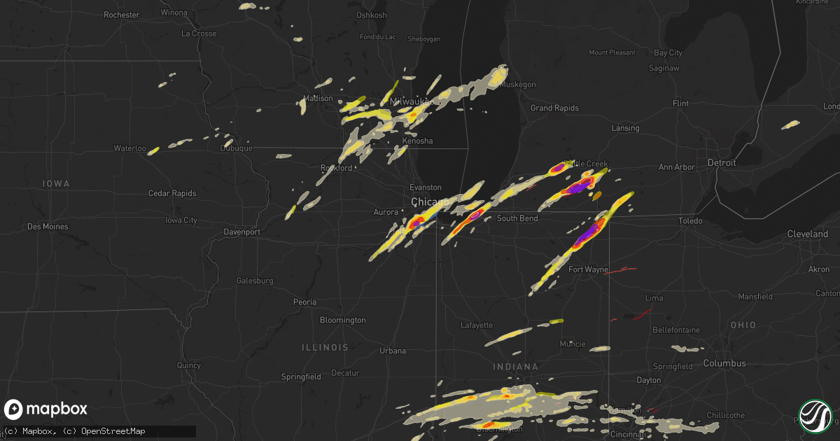
Hail Map on May 7, 2024
Get this storm
May 7 map
$229
one time, instant access
Download today. No call, no setup
Keep the $229
Bought the map and want the full workflow? Apply the entire $229 to a subscription within 7 days. None of it is wasted.
Every map, not just this one
This buys you this map. Subscription and you get every map we run, in the markets you choose from a few cities to whole states to nationwide. Plus real-time alerts the moment a storm fires.
Contact data
Name, contact info, occupancy, even credit band for addresses in the footprint. You go from where it hit to who to call.
Become the source they trust
Unlimited branding weather history reports on demand. You already have the documented answer ready for the property owner, and you are the one who showed up with it.
Property data and RoofTrace estimates
Pull up any address you have got, its value and the exact code rules for that jurisdiction, straight from One Click Code. Then RoofTrace estimates the squares, pitch, and roof value, priced the way you price.
States Impacted by Hail Map on May 7, 2024
Storm reports
Iowa
| Date | Description |
|---|---|
| 05/07/20246:40 PM CDT | Multiple tree limbs down... Largest was roughly 6 inches. |
| 05/07/20246:35 PM CDT | Large tree down in polk city. Time estimated from radar. |
| 05/07/20246:32 PM CDT | Snapped tree branches... Roughly 4 to 5 inches. Time estimated from radar. |
| 05/07/20246:31 PM CDT | Time estimated. |
| 05/07/20246:28 PM CDT | Trained spotter reported quarter size hail at the amazon facility in dubuque. |
| 05/07/20246:26 PM CDT | Large tree branches down. Image posted on social media. Time estimated from radar. |
| 05/07/20246:15 PM CDT | Spotter reported hail went from nickel size to now quarter size. |
| 05/07/20246:15 PM CDT | Spotter reported ha |
| 05/07/20245:10 PM CDT | Social media report with picture. |
| 05/07/20244:13 PM CDT | Spotter measured quarter size hail at this location. |
| 05/07/20244:09 PM CDT | A local report indicates 1.00 inch wind near 1 WNW Independence |
| 05/06/20247:50 PM CDT | Large tree limb snapped off and blocking the roadway. Tree appeared healthy. Time estimated. |
| 05/06/20247:14 PM CDT | Large branch down. Time estimated from radar. |
| 05/06/20247:08 PM CDT | Personal weather station kiaunion5. Time estimated. |
Tennessee
| Date | Description |
|---|---|
| 05/07/20246:25 AM CDT | Facebook report of a tree down in cottontown. |
| 05/07/20244:25 AM CDT | Report of trees down in the big rock area. |
Pennsylvania
| Date | Description |
|---|---|
| 05/07/20242:20 AM CDT | Trees down in southmont. |
| 05/07/20242:15 AM CDT | Numerous trees down near wilpen |
| 05/07/20242:09 AM CDT | Significant tree damage. Possible tornado. |
| 05/07/20242:09 AM CDT | Nws storm survey team found an ef1 tornado with maximum gusts of 95mph to 100mph. Additional details will be found in a future public information statement. |
| 05/07/202412:52 AM CDT | Wires down along hastings avenue. |
| 05/07/202412:52 AM CDT | Wires down along clinton avenue extension. |
| 05/07/202412:50 AM CDT | Metal debris on i-376 |
| 05/07/202412:49 AM CDT | **correction to date** nws storm survey team found an ef1 tornado along aten road. Details will be found in a public information statement. |
West Virginia
| Date | Description |
|---|---|
| 05/07/202412:15 AM CDT | Strong tornado damage |
| 05/07/202412:13 AM CDT | Homes heavily damaged on international road. Radar confirmed tornado. |
| 05/07/202412:13 AM CDT | *** 1 inj *** mobile homes damaged along sheperds valley road. |
| 05/07/202412:13 AM CDT | *** 1 inj *** one woman was injured by broken glass along international drive and taken to the hospital. |
| 05/07/202412:13 AM CDT | Trees and power lines down near locust hill road and route 8. Debris signature on radar. |
Wisconsin
| Date | Description |
|---|---|
| 05/07/20246:48 PM CDT | Dime to quarter size hail. |
| 05/07/20246:47 PM CDT | Report of 2 trees down in town of oxford and 1 tree down in village of westfield. Time estimated from radar. |
| 05/07/20246:33 PM CDT | Some quarter size... Most nickel size. Also reported by emergency manager. |
| 05/07/20245:30 PM CDT | Variable hail sizes up to 1 inch in diameter. Stripped leaves and branches off trees. |
| 05/07/20244:22 PM CDT | A local report indicates 1.75 inch wind near 3 SE Cumberland |
| 05/07/20243:42 PM CDT | Report from mping: quarter |
| 05/07/20243:38 PM CDT | Report from mping: quarter |
| 05/07/20243:36 PM CDT | Report from mping: quarter |
| 05/07/20243:32 PM CDT | Report |
| 05/07/20243:32 PM CDT | Report from mping: half dollar |
| 05/07/20243:31 PM CDT | Picture with measurement shown on wisn 12. |
| 05/07/20243:30 PM CDT | Photos of measured 1in hail from spotter on facebook. |
| 05/07/20243:30 PM CDT | Report from mping: quarter |
| 05/07/20243:30 PM CDT | A local report indicates 1.00 inch wind near 1 S South Milwaukee |
| 05/07/20243:30 PM CDT | Photos of hail provided via email. |
| 05/07/20242:38 PM CDT | Photos and video relayed by amateur radio showing snapped trees and tree limbs near prestwick drive in the geneva national golf community. Time estimated via radar. |
| 05/07/20242:24 PM CDT | A local report indicates 1.00 inch wind near Sussex |
| 05/07/20242:24 PM CDT | Semi rolled over near intersection of hwy 67 and us 14. Power lines down in area of walworth and fontana. Time estimated from radar. |
| 05/07/20242:23 PM CDT | Large tree branch down and leaning power pole near intersection of hwy 67 and county rd b. |
| 05/07/20242:21 PM CDT | Nws survey team confirmed an ef-0 with 80 mph winds across southern walworth county from east of sharon to west of walworth. |
| 05/07/20242:19 PM CDT | Nws storm survey confirmed a short lived ef-1 with 90 mph winds south of darien. |
| 05/07/20242:18 PM CDT | Report from mping: quarter |
| 05/06/20249:09 PM CDT | Report from mping: quarter |
| 05/06/20248:58 PM CDT | Several reports around town of trees... Limbs and power lines down. Time est by radar. |
| 05/06/20248:55 PM CDT | Multiple reports around town of trees... Limbs and power lines down. Time est by radar. |
| 05/06/20248:45 PM CDT | Tree down at the knob road and warren road intersection. Time estimated by radar. |
| 05/06/20248:45 PM CDT | Report from mping: quarter |
| 05/06/20248:39 PM CDT | Tree downed... Damaging a vehicle. |
| 05/06/20248:38 PM CDT | Public report of nickel to quarter size hail in mukwonago. Time estimated via radar. |
| 05/06/20248:35 PM CDT | Time estimated by radar. Report of tree down along sheridan springs road. |
| 05/06/20248:29 PM CDT | Multiple reports of trees and power lines down between southern delavan area and geneva area. No specific address at this time. Time estimated from radar. |
| 05/06/20248:25 PM CDT | Time estimated by radar. Trees damage reported across delavan. |
| 05/06/20248:25 PM CDT | Public report of broken tree limbs near the community of avalon. |
| 05/06/20247:41 PM CDT | Report of wires down at meadow lane/county rd vv. Time estimated by radar. |
| 05/06/20247:41 PM CDT | Report of wires down. Time estimated by radar. |
| 05/06/20247:00 PM CDT | Report from mping: quarter |
Arkansas
| Date | Description |
|---|---|
| 05/07/20245:52 AM CDT | Quarter-sized hail observed in the holub crossing area. |
| 05/07/20244:14 AM CDT | A local report indicates 1.00 inch wind near 2 N Stuttgart |
| 05/07/20243:18 AM CDT | A local report indicates 1.50 inch wind near Blakemore |
| 05/07/20242:38 AM CDT | Measured to 60 mph at lit adams field asos. |
| 05/07/20242:27 AM CDT | A local report indicates 1.25 inch wind near Kensington Place |
| 05/07/20242:21 AM CDT | Large tree blown over onto colonel glenn road near the humane society. |
| 05/07/20241:00 AM CDT | Image of damage from possible tornado. |
| 05/07/202412:52 AM CDT | A local report indicates 2.00 inch wind near 1 NNE Hot Springs |
| 05/07/202412:49 AM CDT | Video from public showing tornado over lake hamilton... With power flashes. Debris signature on radar shortly afterwards. |
| 05/07/202412:30 AM CDT | ***delayed report*** a storm survey determined that an ef2 tornado occurred across portions of garland county. Peak winds were estimated to be 120 mph... Max width was |
Missouri
| Date | Description |
|---|---|
| 05/07/20241:43 PM CDT | A tornado developed west of county road 2160 in randolph county during the early morning on may 7. It was initially weak... Damaging mainly trees along county road 2180 |
| 05/07/202410:59 AM CDT | Delayed report. Tree down over roadway at the 1000 and 1500 blocks of old springfield road. Time estimated from radar. |
| 05/07/20246:48 AM CDT | Social media report with photo. Time/location approximate... Augmented using radar. |
| 05/07/202412:56 AM CDT | Wind gusts estimated 50 to 60 mph along with pea size hail. |
| 05/07/202412:42 AM CDT | Time estimated from radar. |
Kentucky
| Date | Description |
|---|---|
| 05/07/20246:03 PM CDT | Trees down at natural bridge state park near the campground and hoedown island. The event time is radar estimated. |
| 05/07/20246:50 AM CDT | Report from mping of quarter |
| 05/07/20246:22 AM CDT | Tree on vehicle on meadow creek road. |
| 05/06/20248:45 PM CDT | Tree down. Time estimated from radar. |
| 05/06/20248:25 PM CDT | Several trees down north of the aa highway... Just west of vanceburg. |
Virginia
| Date | Description |
|---|---|
| 05/07/20246:32 PM CDT | A local report indicates 1.00 inch wind near 2 N Danville City |
| 05/07/20246:21 PM CDT | A local report indicates 1.00 inch wind near 4 NW Westover Hills |
Michigan
| Date | Description |
|---|---|
| 05/07/20246:43 PM CDT | Time estimated from radar. |
| 05/07/20246:22 PM CDT | Time estimated by radar. |
| 05/07/20246:18 PM CDT | Two trained spotters reporting a tornado touchdown in portage. |
| 05/07/20246:13 PM CDT | Multiple trees and power lines down across road. Possible tornado. |
| 05/07/20245:45 PM CDT | Trained spotter recorded video of a large cone tornado in colon. Time given by spotter. |
| 05/07/20245:17 PM CDT | A local report indicates 1.50 inch wind near Coldwater |
| 05/07/20245:14 PM CDT | Numerous trees and wires down in tekonsha. Time is estimated via radar. |
| 05/07/20245:14 PM CDT | Numerous trees and wires down in tekonsha. Time is estimated via radar. 0 to 60 feet high. |
| 05/07/20245:11 PM CDT | Picture shared on twitter of hail stone measuring upwards of 4 inches. |
| 05/07/20245:08 PM CDT | Photo on x/twitter shows a 4 inch diameter hailstone!. |
| 05/07/20245:07 PM CDT | A brief ef-1 tornado developed southwest of union city... Mi as larger tornado dissipated to the northwest |
| 05/07/20245:06 PM CDT | Fed ex building damaged. Possible tornado. |
| 05/07/20245:06 PM CDT | Estimated 3 foot diameter trees down. Estimated time via radar. |
| 05/07/20245:05 PM CDT | *** 1 inj *** a lady taking cover from possible tornado was hit by debris as she got out of her car. Her leg is broken. |
| 05/07/20245:01 PM CDT | A local report indicates 2.00 inch wind near 2 NW Portage |
| 05/07/20245:00 PM CDT | Tree damage near glenwood. |
| 05/07/20245:00 PM CDT | Video of debris being lofted in sherwood. Time estimated by tds on radar. Relayed by trained spotter. |
| 05/07/20245:00 PM CDT | Tree damage reported in leonidas by broadcast media. |
| 05/07/20245:00 PM CDT | Pictures shared of up to tennis ball size hail. |
| 05/07/20245:00 PM CDT | Tornado damage in sherwood along arney road relayed by trained spotters. Trees snapped and damage to at least one house. Time estimated from radar. |
| 05/07/20245:00 PM CDT | Photo of a tornado in mendon and time of occurrence relayed by broadcast media. Several photos from x/twitter show a large tornado on the ground in and near mendon mi. |
| 05/07/20245:00 PM CDT | Radar confirmed tornado. Time estimated via radar. |
| 05/07/20244:56 PM CDT | A local report indicates 1.75 inch wind near 2 NNW Fairfax |
| 05/07/20244:55 PM CDT | Large trees down... Power lines down... Shingles scattered around. Possible tornado. Time estimated based on radar. |
| 05/07/20244:55 PM CDT | The ef2 tornado touched down near the intersection of south 10th street and west r avenue and traveled east/northeast for around 11 miles until it lifted north of east |
| 05/07/20244:53 PM CDT | Reports of trees down and farm damage on farrand rd... West of the roundabout. |
| 05/07/20244:53 PM CDT | Corrects previous tstm wnd dmg report from 1 wnw colon. Reports of trees down and farm damage on farrand rd... West of the roundabout. |
| 05/07/20244:52 PM CDT | Trees snapped near colon... Likely from a tornado. Photos sent in by a trained spotter. Confirmed tds on radar. Time estimated by radar. |
| 05/07/20244:50 PM CDT | Corrects time of previous tornado report from colon. Trained spotter recorded video of a large cone tornado in colon. |
| 05/07/20244:50 PM CDT | Damage to a home and trees snapped in colon. Time estimated by tds on radar. |
| 05/07/20244:50 PM CDT | Report from mping: quarter |
| 05/07/20244:50 PM CDT | A local report indicates a tornado near 3 ESE Mendon |
| 05/07/20244:43 PM CDT | Photo on facebook of a large tornado on the ground between centreville and colon... Just north of nottawa. Time estimated by radar. |
| 05/07/20244:42 PM CDT | Video on facebook shows tornado on the ground near centreville mi. Time estimated from radar. |
| 05/07/20244:41 PM CDT | A tornado touched down in st. Joseph county on the south side of centreville and then tracked northeast... Passing north of colon... Crossing into branch county near ha |
| 05/07/20244:32 PM CDT | Chaser provided photos of several trees uprooted and snapped just south of decatur. Time is estimated by radar. |
| 05/07/20244:30 PM CDT | Delayed report. Time estimated by radar. |
| 05/07/20244:15 PM CDT | Time estimated by radar. Facebook photo shows two center pivots flipped and damaged. At the intersection of atwood road and gage street. |
| 05/07/20244:15 PM CDT | Photos on facebook show heavy tree damage near twin lakes... Just northeast of dowagiac. Numerous trees of varying sizes snapped or uprooted. Time estimated by radar. |
| 05/07/20244:11 PM CDT | An ef-1 tornado with maximum wind speeds of 95 mph occurred in the early evening of may 7th in cass county... Mi. The tornado touched down in a field just north of the |
| 05/07/20244:00 PM CDT | Delayed report. |
| 05/07/20243:38 PM CDT | A local report indicates 1.00 inch wind near New Buffalo |
| 05/06/20248:43 PM CDT | St. Clair county dispatch relayed a report of fence and property damage to a home along ruskin ave. |
| 05/06/20248:38 PM CDT | Damage to a garage door and exterier wall occurred. |
| 05/06/20248:28 PM CDT | Measured at m-18 midot site. |
| 05/06/20248:28 PM CDT | Measured at m-18 midot site |
| 05/06/20248:28 PM CDT | Boat storage structure blown down at a marina in harrison township. |
| 05/06/20248:23 PM CDT | Tree downed on house near harvard shore dr and jefferson ave. |
Indiana
| Date | Description |
|---|---|
| 05/07/20246:58 PM CDT | A local report indicates 1.00 inch wind near Manilla |
| 05/07/20246:56 PM CDT | Report from mping: quarter |
| 05/07/20246:47 PM CDT | Late report of efu tornado with unknown peak wind...path length 0.77 miles. Max width 30 yards...clear video and drone ir image showed swirl yet no damage crossing fiel |
| 05/07/20246:45 PM CDT | Late report of ef1 tornado with peak wind 110 mph...path length 0.16 miles. Max width 30 yards...metal barn hit but nearby silos untouched. |
| 05/07/20246:31 PM CDT | Late report of ef0 tornado with peak wind 85 mph...path length 0.78 miles. Max width 50 yards...numerous uprooted trees and little home damage. Ended in shelby co. |
| 05/07/20246:27 PM CDT | Report from mping: quarter |
| 05/07/20246:25 PM CDT | Delayed report. Report from mping: baseball |
| 05/07/20246:22 PM CDT | Report from mping: quarter |
| 05/07/20246:22 PM CDT | A local report indicates 3.50 inch wind near Ashley |
| 05/07/20246:22 PM CDT | A local report indicates 1.00 inch wind near New Whiteland |
| 05/07/20246:18 PM CDT | Facebook photo of several 3 inch hailstones. |
| 05/07/20246:15 PM CDT | Delayed report relayed by broadcast media. Ping pong ball hail near trine university in angola. Time estimated by radar. |
| 05/07/20246:15 PM CDT | A local report indicates 1.75 inch wind near 1 S Angola |
| 05/07/20246:12 PM CDT | A local report indicates 1.75 inch wind near Pleasant Lake |
| 05/07/20246:09 PM CDT | Time estimated by radar. |
| 05/07/20246:09 PM CDT | Time estimated from radar. |
| 05/07/20246:05 PM CDT | Several 3 inch hailstones per facebook reports. |
| 05/07/20246:05 PM CDT | Hail damage reported in corunna to car... Siding... And roofs. Hailstones up to 3 inches in diameter fell. Time estimated by radar. |
| 05/07/20246:00 PM CDT | A local report indicates 1.00 inch wind near 1 N Hudson |
| 05/07/20245:57 PM CDT | Time estimated by radar. |
| 05/07/20245:55 PM CDT | Damage to cars... Windows... And siding on homes in kendallville due to hailstones up to 3 inches in diameter. |
| 05/07/20245:55 PM CDT | Time estimated by radar. Large tree... Estimated 1 to 2 feet in diameter... Uprooted in albion. |
| 05/07/20245:55 PM CDT | A local report indicates 1.75 inch wind near 2 NW Brooklyn |
| 05/07/20245:54 PM CDT | A local report indicates 1.75 inch wind near 2 W Lisbon |
| 05/07/20245:53 PM CDT | Hail occurred between 6:50 and 6:55 pm. |
| 05/07/20245:52 PM CDT | Delayed report and time estimated by radar. Several healthy tree branches around 12in in diameter broken and a couple more uprooted just west of n 350 e. Also hail dama |
| 05/07/20245:50 PM CDT | A local report indicates 3.00 inch wind near Kendallville |
| 05/07/20245:39 PM CDT | Along sr 135. |
| 05/07/20245:35 PM CDT | Photos on facebook shows several barns damaged in larwill. Time estimated from radar. |
| 05/07/20245:35 PM CDT | Time estimated by radar. Photo on facebook of a large tree snapped at the base in columbia city. Estimated to be 1 to 2 feet in diameter. |
| 05/07/20245:34 PM CDT | Time estimated by radar. Large tree snapped in columbia city... Estimated 12 t |
| 05/07/20245:34 PM CDT | Time estimated by radar. Large tree snapped in columbia city... Estimated 12 to 18 inches in diameter. |
| 05/07/20245:30 PM CDT | Winds gusting to estimated 45 mph. |
| 05/07/20245:27 PM CDT | A local report indicates 1.00 inch wind near 1 S North Manchester |
| 05/07/20245:27 PM CDT | Barn downed in south whitley. Unknown how strong wind speeds were. Time estimated by radar. |
| 05/07/20245:27 PM CDT | Time estimated by radar. Barn downed in south whitley. |
| 05/07/20245:26 PM CDT | Thunderstorm winds downed a few 12 inch diameter trees along fairview road at leaning tree road and peterman road. Some fences down and some roofs damaged. Time estimat |
| 05/07/20245:26 PM CDT | Minor limb damage. |
| 05/07/20245:25 PM CDT | Large tree limbs down. Time estimated by radar. |
| 05/07/20245:22 PM CDT | Powerlines down. Some roads are being blocked off. |
| 05/07/20245:22 PM CDT | Tornado near 200w just north of us 20. |
| 05/07/20245:22 PM CDT | Also recorded a 51 mph gust on an anemometer. |
| 05/07/20245:20 PM CDT | Delayed report. Report of a few trees down and a few large limbs. Time estimated from radar. |
| 05/07/20245:15 PM CDT | Video on facebook shows powerlines snapped on state road 13. Also a report half a mile down the road of a barn destroyed. |
| 05/07/20245:15 PM CDT | Large tree branches snapped in north manchester |
| 05/07/20245:12 PM CDT | Report of 3 damaged residences... Roof off one of them... As well uprooted trees and power lines down. On state route 13 between 1000 and 1100 north. |
| 05/07/20245:11 PM CDT | We can confirm a brief ef-u tornado touched down in a field north of w 100 n and west of w landis road at 6:11 pm edt on tuesday... May 7th. The tornado dissipated over |
| 05/07/20245:11 PM CDT | Numerous reports of a funnel cloud were received from west of angola to north of angola including in the area of crooked and loon lakes. Video footage confirms a brief |
| 05/07/20244:50 PM CDT | Delayed report. Tree damage near intersection of 400n/100e. |
| 05/07/20244:40 PM CDT | A local report indicates 1.25 inch wind near 2 NNE Belle Union |
| 05/07/20244:10 PM CDT | A local report indicates 1.50 inch wind near Reelsville |
| 05/07/20244:08 PM CDT | Report from mping. |
| 05/07/20244:00 PM CDT | Hail damage to vehicles in downtown michigan city. Public report of 2 to 2.5 inch hailstones. |
| 05/07/20244:00 PM CDT | Wind briefly reaching 50-60 mph amid t |
| 05/07/20244:00 PM CDT | Wind briefly reaching 50-60 mph amid torrential rain with no hail. |
| 05/07/20243:56 PM CDT | A local report indicates 1.00 inch wind near 2 N Staunton |
| 05/07/20243:40 PM CDT | A local report indicates 1.00 inch wind near Terre Haute |
| 05/07/20243:35 PM CDT | Report from mping: quarter |
| 05/07/20243:28 PM CDT | A local report indicates 1.00 inch wind near 1 W Michiana Shores |
| 05/07/20243:28 PM CDT | A local report indicates 1.00 inch wind near 1 W Michiana Shores |
| 05/07/20243:26 PM CDT | Reported by trained spotter. |
| 05/07/20243:23 PM CDT | A local report indicates 2.50 inch wind near Michigan City |
| 05/07/20243:23 PM CDT | A local report indicates 2.50 inch wind near Michigan City |
| 05/07/20243:22 PM CDT | A local report indicates 1.75 inch wind near 1 NW Michigan City |
| 05/07/20243:22 PM CDT | A local report indicates 1.75 inch wind near 1 NW Michigan City |
| 05/07/20243:20 PM CDT | A local report indicates 2.00 inch wind near 1 S Michigan City |
| 05/07/20243:16 PM CDT | A local report indicates 1.25 inch wind near Town of Pines |
| 05/07/20243:16 PM CDT | An nws storm survey found that tree and vehicle damage in and near the town of pines area was caused by a microburst and wind-driven large hail. |
| 05/07/20243:15 PM CDT | A local report indicates 3.50 inch wind near Michigan City |
| 05/07/20243:11 PM CDT | Cr50 and us 20 tree down on road. |
| 05/07/20243:07 PM CDT | Large trees snapped near base. |
| 05/07/20243:06 PM CDT | Trees down. |
| 05/07/20243:05 PM CDT | Numerous trees reported down in area. |
| 05/07/20243:05 PM CDT | A local report indicates 1.25 inch wind near 2 NNE Porter |
| 05/07/20242:57 PM CDT | Photo shared on social media showing quarter size hail in portage. Time estimated from radar. |
| 05/07/20242:52 PM CDT | Time estimated by radar. Relayed via mping. |
| 05/07/20242:49 PM CDT | A local report indicates 1.50 inch wind near 2 SE Hobart |
| 05/07/20242:30 PM CDT | Corrects previous tornado report from 3 wsw michigan city. A storm survey of the area near town of pines found vehicle and tree damage consistent with a microburst as w |
| 05/07/20242:30 PM CDT | Public report of vehicle damage and tree limbs down across 6 acres of land on the porter and la porte county line. They said they had a sudden burst of wind followed by |
| 05/07/20241:16 AM CDT | Several trees uprooted and branches snapped on the southeast side of tell city. |
| 05/06/202410:26 PM CDT | Large tree limb over sr 135. |
| 05/06/20249:50 PM CDT | A local report indicates 1.75 inch wind near 1 W Ellettsville |
| 05/06/20248:43 PM CDT | Widespread tree damage along route 1... North of guilford. |
| 05/06/20248:27 PM CDT | A local report indicates 1.00 inch wind near 3 SE Greensburg |
| 05/06/20248:25 PM CDT | Trees down on us-31. |
| 05/06/20248:23 PM CDT | Light debris on i-65 near perry crossing. |
| 05/06/20248:23 PM CDT | The nws in louisville conducted a storm survey and found ef0 85 mph wind damage. The tornado was 0.41 miles long with a width of 60 yards. For more information... Pleas |
| 05/06/20248:19 PM CDT | Tree down near finks road and county road 700 north near osgood. Time estimated from radar. |
| 05/06/20248:17 PM CDT | Tree down near state route 229 and 1300 north near batesville. |
| 05/06/20248:14 PM CDT | Tree down on underpass road and county line road near batesville. |
| 05/06/20248:06 PM CDT | Roof and siding damage to a home. Tree damage. Possible tornado. Time estimated. |
| 05/06/20247:56 PM CDT | Ef1 tornado confirmed northeast of brookville in franklin county indiana. Maximum winds of 110 mph. |
| 05/06/20247:41 PM CDT | On old union church rd just south of east rainforth rd... Trees and power lines down... And carport blown in the road. Time estimated from radar. |
| 05/06/20247:33 PM CDT | Thunderstorm winds snapped off tops of trees 50 to 60 feet high. |
| 05/06/20247:31 PM CDT | A local report indicates 1.00 inch wind near 1 E Saint Paul |
| 05/06/20247:25 PM CDT | Late report of ef0 tornado with peak wind 81 mph...path length 4.48 miles. Max width 100 yards...utility poles downed on county roads 500 east and 700 east. |
| 05/06/20247:18 PM CDT | Touched down in a field east of milroy. Nearby trees and power lines damaged. |
| 05/06/20247:15 PM CDT | Third hail producing storm following pea hail in first two rounds. |
| 05/06/20247:08 PM CDT | Numerous large and healthy trees downed. |
| 05/06/20247:06 PM CDT | Trees blown down... Location estimated. |
| 05/06/20247:05 PM CDT | Late report of trees downed by thunderstorm winds with power outages. |
| 05/06/20247:01 PM CDT | Thunderstorm winds downed 2 foot diameter tree onto road. |
Georgia
| Date | Description |
|---|---|
| 05/06/20248:37 PM CDT | Tree down in road at 500 block of welco |
| 05/06/20248:37 PM CDT | Tree down in road at 500 block of welcome hill rd near club dr. |
| 05/06/20248:37 PM CDT | Tree down at w halls valley rd and old highway 27. |
| 05/06/20248:37 PM CDT | Tree down at longhollow rd and browns rd. |
Kansas
| Date | Description |
|---|---|
| 05/07/20246:55 AM CDT | Report from mping: half dollar |
| 05/07/20246:54 AM CDT | Mostly quarters but one hail stone was 2 inches in diameter. |
North Carolina
| Date | Description |
|---|---|
| 05/07/20246:58 PM CDT | Tree downed by thunderstorm winds near the intersection of lakeview drive and fairway drive. |
| 05/07/20246:10 PM CDT | A business on denny road reported hail slightly larger than the size of a quarter. |
| 05/07/20246:06 PM CDT | Report of a couple trees blown down at scotts creek road near stevenson farm rd. Time estimated from radar. |
| 05/07/20245:59 PM CDT | Tree down blocking one lane of old winston road. |
| 05/07/20245:42 PM CDT | Tree down in the 290 block of siloam church road... North of the city of siloam. Time estimated from radar data. |
| 05/07/20245:37 PM CDT | Tree and power line down across both lanes of the roadway in the 6900 block of siloam road near siloam baptist church. |
| 05/07/20245:35 PM CDT | A local report indicates 1.75 inch wind near 1 SE Dobson |
| 05/07/20245:32 PM CDT | A local report indicates 1.75 inch wind near 2 ESE Fairview |
| 05/07/20245:11 PM CDT | Tree down in the 700 block of west mount herman church road... Northeast of elkin. Time estaimted from radar data. |
| 05/07/20244:56 PM CDT | A couple trees blown down on willie mcleod rd. Time estimated from radar. |
| 05/07/20244:40 PM CDT | One tree blown down by thunderstorm winds on u.s. Highway 421 south. |
| 05/07/20244:29 PM CDT | At least one tree blown down near n. Wilkesboro. |
| 05/07/20244:24 PM CDT | One tree blown down by thunderstorm winds north of moravian falls. |
| 05/07/20244:13 PM CDT | Large limbs down across yard. |
| 05/07/20244:11 PM CDT | A local report indicates 1.00 inch wind near 3 S Wentworth |
| 05/07/20244:08 PM CDT | A local report indicates 1.00 inch wind near 3 ESE Reidsville |
| 05/07/20243:54 PM CDT | Trees blown down on bethany church rd. Time estimated from radar. |
| 05/07/20243:48 PM CDT | Trees blown down on piney ridge rd. Time estimated from radar. |
| 05/07/20243:36 PM CDT | Trees blown down on clark rd. Time estimated from radar. |
| 05/07/20243:00 PM CDT | Tree down blocking both lanes at pat nixon road and adams ridge road. |
| 05/06/20247:37 PM CDT | Tree downed by thunderstorm winds near the intersection of rockingham lake road and competition court. |
Illinois
| Date | Description |
|---|---|
| 05/07/20246:18 PM CDT | Spotter reported lots of pea to dime size hail with a few up to quarters. Report relayed by em. |
| 05/07/20246:18 PM CDT | Corrects previous hail report from 2 w galva. Spotter reported lots of pea to dime size hail with a few up to quarters. Report relayed by em. |
| 05/07/20242:45 PM CDT | Large branches down... Road impassable by cars on rt 47 and vander karr. |
| 05/07/20242:38 PM CDT | A local report indicates 1.00 inch wind near 1 SW Auburn-Gresham |
| 05/07/20242:35 PM CDT | Barn collapse. |
| 05/07/20242:30 PM CDT | Corrects time on previous hail report from 1 sw auburn-gresham. |
| 05/07/20242:30 PM CDT | A local report indicates 2.00 inch wind near 2 N Tinley Park |
| 05/07/20242:29 PM CDT | Multiple reports of tree damage across the south side of chicago. The damage appeared to be most concentrated in the washington heights... Roseland... Chatham... Avalon |
| 05/07/20242:27 PM CDT | Relayed via mping. Time estimated via radar. |
| 05/07/20242:26 PM CDT | Report from mping: quarter |
| 05/07/20242:25 PM CDT | Report from mping: half dollar |
| 05/07/20242:25 PM CDT | Corrects time on previous hail report from alsip. |
| 05/07/20242:23 PM CDT | Time estimated by radar. Relayed via mping. |
| 05/07/20242:23 PM CDT | Report from mping: quarter |
| 05/07/20242:23 PM CDT | Report from mping: quarter |
| 05/07/20242:23 PM CDT | Corrects time on previous hail report from crestwood. |
| 05/07/20242:22 PM CDT | A local report indicates 1.00 inch wind near Homer Glen |
| 05/07/20242:22 PM CDT | A local report indicates 1.50 inch wind near Palos Heights |
| 05/07/20242:22 PM CDT | A local report indicates 1.00 inch wind near Homer Glen |
| 05/07/20242:20 PM CDT | Reports of minor gutter damage to homes. O 18 inches in diameter. |
| 05/07/20242:20 PM CDT | A local report indicates 1.25 inch wind near Orland Park |
| 05/07/20242:20 PM CDT | A local report indicates 1.00 inch wind near Tinley Park |
| 05/07/20242:20 PM CDT | Corrects time on previous hail report from 2 n tinley park. |
| 05/07/20242:20 PM CDT | Reports of minor gutter damage to homes. |
| 05/07/20242:20 PM CDT | A local report indicates 1.00 inch wind near 1 W Palos Park |
| 05/07/20242:20 PM CDT | A local report indicates 1.25 inch wind near Alsip |
| 05/07/20242:20 PM CDT | A local report indicates 1.25 inch wind near Crestwood |
| 05/07/20242:19 PM CDT | Large tree downed on fence... Photo relayed via service account email. Time estimated by radar. |
| 05/07/20242:18 PM CDT | A local report indicates 1.75 inch wind near 1 N Tinley Park |
| 05/07/20242:17 PM CDT | Corrects previous tstm wnd dmg report from 6 nnw harvard. Barn collapse. |
| 05/07/20242:17 PM CDT | Orland park/tinley park - 159th and harlem ave. |
| 05/07/20242:17 PM CDT | Report from mping: quarter |
| 05/07/20242:16 PM CDT | A local report indicates 2.00 inch wind near Orland Park |
| 05/07/20242:16 PM CDT | A local report indicates 1.50 inch wind near Orland Park |
| 05/07/20242:13 PM CDT | 179th near southwest highway. |
| 05/07/20242:12 PM CDT | Photo shared on social media showing hail that fell in mokena. The largest hailstone was approximately 1.5 inches in diameter with most other hailstones being under 1 i |
| 05/07/20242:12 PM CDT | Corrects time on previous hail report from homer glen. |
| 05/07/20242:07 PM CDT | Report from mping: quarter |
| 05/07/20242:07 PM CDT | Report from mping: quarter . |
| 05/07/20242:05 PM CDT | An ef-0 tornado began northwest of capron in northern boone county... Crossed into northwest mchenry county where a barn was destroyed... Then continued across the stat |
| 05/07/20241:56 PM CDT | Report from mping: quarter |
| 05/07/20241:56 PM CDT | Report from mping: quarter . |
| 05/07/20241:53 PM CDT | A local report indicates 1.00 inch wind near Beverly - Chicago |
| 05/07/20241:52 PM CDT | A local report indicates 1.00 inch wind near Merrionette Park |
| 05/07/20241:52 PM CDT | A local report indicates 1.00 inch wind near Merrionette Park |
| 05/07/20241:43 PM CDT | Photos shared on social media showing quarter size hail in channahon. Time estimated from radar. |
| 05/07/202412:33 PM CDT | A local report indicates 1.00 inch wind near Grimes Addition |
| 05/07/202412:24 PM CDT | A local report indicates 1.00 inch wind near 4 NW Tampico |
| 05/07/20247:00 AM CDT | Roof blown off a farm shop on south edge of gridley. |
| 05/07/20241:12 AM CDT | Healthy tree approximately 15 inches in diameter across joppa road. Took power lines down as well. |
| 05/06/20249:33 PM CDT | Asos station klwv lawrenceville ap. |
| 05/06/20248:33 PM CDT | Picture relayed via social media of a large tree branch down. Time estimated via radar. |
| 05/06/20248:23 PM CDT | Mesonet station kilauror58... 64.4 mph wind gust... Matched time and location with tord... Tmdw... And klot wind max. |
| 05/06/20248:14 PM CDT | Several 3-5 inch diameter branches blown down. |
Oklahoma
| Date | Description |
|---|---|
| 05/07/20247:45 AM CDT | Damaged power pole. Facebook report with picture. Time est. From radar. |
Ohio
| Date | Description |
|---|---|
| 05/07/20246:58 PM CDT | Large branches down; home insolation scattered. |
| 05/07/20246:51 PM CDT | Structural damage in macedon... Oh. Time estimated from radar. Possible tornado. |
| 05/07/20246:50 PM CDT | Ef2 tornado confirmed west of coldwater in mercer county ohio. Maximum winds of 120 mph. |
| 05/07/20246:45 PM CDT | Tree uprooted and branches down on sr49 and siegrist-jutte road. Time estimated from radar. Possible tornado. |
| 05/07/202412:20 PM CDT | Large tree and wires down near ridgeland place and montgomery road. |
| 05/07/202410:49 AM CDT | Multiple trees down... One of which causing damage to back porch of residence near intersection of rain rock road and rocky ford road. |
| 05/07/20248:21 AM CDT | Large tree branches thrown and several uprooted. Possible tornado. Time estimated. |
| 05/07/20248:21 AM CDT | Large tree branches thrown and several uprooted. Possible tornado. Time estimated. |
| 05/07/20242:12 AM CDT | Tree and power lines down. Time estimated from radar. |
| 05/07/20242:00 AM CDT | Tree down. Blocking both lanes of state route 522 in the 6700 block. Time estimated from radar. |
| 05/07/20241:54 AM CDT | Tree down blocking both lanes of county road 210. Time estimated from radar. |
| 05/07/202412:00 AM CDT | Damage to houses... Barns... And outbuildings. Possible tornado. |
| 05/07/202412:00 AM CDT | Radar confirmed tornado. Damage to trees and homes near county road 55. Time estimated on radar. |
| 05/06/202411:47 PM CDT | Wires down on heller drive. |
| 05/06/202411:27 PM CDT | House roof ripped off. Widespread trees/power lines down. Time estimated from tcmh tdwr and kpbz wsr-88d velocity data. |
| 05/06/202411:26 PM CDT | Significant wind damage with numerous trees down on vehicles in the neighborhood vicinity of township road 285. Area within about 3/4 mile radius has wind damage. Time |
| 05/06/202411:18 PM CDT | Nws storm survey team found an ef1 tornado with maximum gusts of 105mph that occurred early wednesday morning west of conesville. Additional details will be found in a |
| 05/06/202411:16 PM CDT | Several trees down in the franklin township area. |
| 05/06/202411:15 PM CDT | Major roof damage to house and downed trees. Garage destroyed. |
| 05/06/202411:14 PM CDT | Trees onto homes and garage destroyed. Possible tornado. |
| 05/06/202411:12 PM CDT | Multiple trees down. Time estimated by radar. |
| 05/06/202411:10 PM CDT | Downed power lines. |
| 05/06/202411:09 PM CDT | Corrects date for previous tstm wnd dmg report from 3 nnw frazeysburg. Possible tornado. New garage damaged. Time estimated from tcmh tdwr velocity signature. |
| 05/06/202411:03 PM CDT | Nws storm survey team found an ef1 tornado with maximum gusts of 100mph that occurred early wednesday morning north of frazeysburg. Additional details will be found in |
| 05/06/202411:00 PM CDT | Damage to barn and outbuilding in the 6800 block of licking valley road. Public report to nws pittsburgh relayed to nws wilmington. |
| 05/06/202410:59 PM CDT | Tree down along stoney road. |
| 05/06/202410:49 PM CDT | Nws storm survey confirms an ef0 tornado with maximum estimated wind speeds of 75 mph and a path length of 3.1 miles. Damage primarily to trees and outbuildings. |
| 05/06/20249:54 PM CDT | Report from mping: quarter |
| 05/06/20249:35 PM CDT | Tree fell into two houses. Time estimated from radar data. |
| 05/06/20249:29 PM CDT | Large tree snapped. Time estimated from radar. |
| 05/06/20249:27 PM CDT | Ef0 tornado confirmed north of blanchester in clinton county ohio. Maximum winds of 85 mph. |
| 05/06/20249:27 PM CDT | Ef0 tornado confirmed west of clarksville in warren county ohio. Maximum winds of 80 mph. |
| 05/06/20249:25 PM CDT | Numerous trees down near 92 irvin road near blanchester. Barn destroyed near the intersection of irvin road and route 133. |
| 05/06/20249:18 PM CDT | Large tree down... Damaging 2 houses. Time estimated from radar. |
| 05/06/20249:18 PM CDT | Ef0 tornado confirmed northeast of morrow in warren county ohio. Maximum winds of 80 mph. |
| 05/06/20249:16 PM CDT | Multiple trees and power poles down along mason morrow millgrove road. Time estimated from radar data. |
| 05/06/20249:15 PM CDT | Ef1 tornado confirmed near morrow in warren county ohio. Maximum winds of 95 mph. |
| 05/06/20249:14 PM CDT | Ef-0 tornado confirmed 2e lebanon in warren county ohio. Max winds of 65 mph. |
| 05/06/20249:13 PM CDT | Multiple trees and power lines down. Time estimated from radar data. |
| 05/06/20249:13 PM CDT | Report from mping: quarter |
| 05/06/20249:10 PM CDT | Ef-1 tornado confirmed 2ne south lebanon in warren county ohio. Max winds of 90 mph. |
| 05/06/20249:02 PM CDT | Multiple large trees damaged; outbuilding damage. Possible tor with cc dropout. |
| 05/06/20249:00 PM CDT | Several pine trees snapped. |
| 05/06/20248:57 PM CDT | Ef0 tornado confirmed in middletown in butler county ohio. Maximum winds of 80 mph. |
| 05/06/20248:56 PM CDT | Siding pulled from a metal building. Semi trailer rolled. Time estimated. |
| 05/06/20248:20 PM CDT | Ef1 tornado confirmed south-southeast of oxford... Ohio. Maximum winds of 110 mph. |
| 05/06/20248:17 PM CDT | Flying debris damaged a car. Time estimated. Possible tornado. |
| 05/06/20248:14 PM CDT | Approximately 50 trees downed in the pond run area of nile township. Time estimated. |
| 05/06/20248:13 PM CDT | Approximately 100 trees down in shawnee state forest per forest service manager. Time estimated. |
| 05/06/20247:56 PM CDT | Trained spotter observed a very brief tornado about 2 miles sse of belmore. A friend closer to the storm confirmed it visually on the ground for a few seconds. |
| 05/06/20247:54 PM CDT | A trained spotter reported a brief tornado touched down south of belmore... Oh at 8:54 pm edt may 7th. Videos confirm that a tornado did touch down in a field just east |
| 05/06/20247:44 PM CDT | Damage to multiple farm buildings. Possible tornado. |
| 05/06/20247:40 PM CDT | Numerous photos on facebook of a funnel cloud nearly on the ground between melrose and oakwood. Additional photos show the tornado on the ground near oakwood. Fairly ce |
| 05/06/20247:36 PM CDT | Photo on x/twitter between melrose and leipsic of a tornado on the ground. Time estimated by radar. |
| 05/06/20247:35 PM CDT | Corrects previous tstm wnd dmg report from 1 n greenville. Roof damage. Trees down on parkside drive. |
| 05/06/20247:31 PM CDT | Multiple trees down... Structural damage. Roofs destroyed. Possible tornado. |
| 05/06/20247:29 PM CDT | Tree blown down in front of house on south side of rhoades ave in greenville. |
| 05/06/20247:29 PM CDT | Small tree down on wagner avenue. Time estimated from radar data. |
| 05/06/20247:28 PM CDT | Damage to harmon field and press box is destroyed. Time estimated from radar. |
| 05/06/20247:28 PM CDT | Press box damaged at greenville high school football stadium. Time estimated from radar data. |
| 05/06/20247:24 PM CDT | Ef1 tornado confirmed in and near greenville in darke county ohio. Maximum winds of 110 mph. |
| 05/06/20247:20 PM CDT | Ef2 tornado confirmed west of new knoxville in mercer and auglaize counties in ohio. Maximum winds of 130 mph. |
| 05/06/20247:19 PM CDT | Mostly pea-sized hail... But a few stones as large as a quarter mixed in. |
| 05/06/20247:16 PM CDT | Emergency management sent drone footage which shows scoured dirt through a freshly plowed field along road 166 between road 191 and ohio 66. The track terminates near a |
| 05/06/20247:13 PM CDT | Report of tornado with visible soil lofted along highway 613 west of oakwood. |
| 05/06/20247:11 PM CDT | Several reports of funnel clouds and a touchdown were received from near latty east to south of melrose and west of oakwood. The most extensive damage occurred north of |
| 05/06/20247:09 PM CDT | Corrects time of previous tornado report from 2 w melrose. Additional review by emergency management and nws found damage near belmore... So the time and path length of |
| 05/06/20247:08 PM CDT | Van wert county ema relayed a photo of a tornado. Further investigation confirmed this damaged the house of a relative. Time estimated. |
| 05/06/20247:06 PM CDT | Small to medium limbs downed. |
Cities Impacted by Hail Map on May 7, 2024
- Alma, AR
- Mulberry, AR
- Ozark, AR
- Melvin, TX
- Mount Washington, KY
- Prophetstown, IL
- Milledgeville, IL
- Polo, IL
- Sterling, IL
- Rock Falls, IL
- Lyndon, IL
- Dixon, IL
- Baileyville, IL
- Oregon, IL
- Mount Morris, IL
- Leaf River, IL
- Kinsman, IL
- Verona, IL
- Morris, IL
- Mazon, IL
- Winnebago, IL
- Byron, IL
- Channahon, IL
- Wilmington, IL
- Coal City, IL
- Minooka, IL
- Joliet, IL
- Rockford, IL
- Elwood, IL
- Shorewood, IL
- Forreston, IL
- Alsip, IL
- Homer Glen, IL
- Franklin Grove, IL
- Machesney Park, IL
- Roscoe, IL
- Loves Park, IL
- Clinton, WI
- Plainfield, IL
- Chicago, IL
- New Lenox, IL
- Manhattan, IL
- Mokena, IL
- Lockport, IL
- Evergreen Park, IL
- Orland Park, IL
- Lemont, IL
- Waukesha, WI
- Wales, WI
- Delafield, WI
- Oak Lawn, IL
- Caledonia, IL
- South Beloit, IL
- Poplar Grove, IL
- Tinley Park, IL
- Belvidere, IL
- Garden Prairie, IL
- Janesville, WI
- Romeoville, IL
- Beloit, WI
- Dousman, WI
- Capron, IL
- Harvard, IL
- Crest Hill, IL
- Morehead, KY
- Oak Forest, IL
- Palos Heights, IL
- Palos Park, IL
- Frankfort, IL
- Crestwood, IL
- Midlothian, IL
- Whitewater, WI
- Avalon, WI
- Delavan, WI
- Sharon, WI
- Darien, WI
- Pewaukee, WI
- Palos Hills, IL
- Worth, IL
- Chicago Ridge, IL
- Robbins, IL
- Blue Island, IL
- Riverdale, IL
- Verona, WI
- Owingsville, KY
- Salt Lick, KY
- Hickory Hills, IL
- Lyons, IL
- La Grange, IL
- Brookfield, IL
- Sussex, WI
- Hartland, WI
- Belleville, WI
- Walworth, WI
- Mount Horeb, WI
- Bridgeview, IL
- Willow Springs, IL
- Marengo, IL
- Cross Plains, WI
- Williams Bay, WI
- Cedar Lake, IN
- Elkhorn, WI
- Lake Geneva, WI
- Fontana, WI
- Hometown, IL
- La Grange Park, IL
- Burbank, IL
- Hobart, IN
- Portage, IN
- Merrillville, IN
- Menomonee Falls, WI
- Colgate, WI
- Valparaiso, IN
- Germantown, WI
- Richfield, WI
- Chesterton, IN
- Eagle, WI
- Martinsville, IL
- Panther, WV
- Casey, IL
- Burlington, WI
- Crown Point, IN
- Mohawk, WV
- Marshall, IL
- East Troy, WI
- Rochester, WI
- Waterford, WI
- Springfield, WI
- Hebron, IL
- Beverly Shores, IN
- Michigan City, IN
- Markham, IL
- Westville, IN
- Mukwonago, WI
- Mchenry, IL
- Iaeger, WV
- Ringwood, IL
- Spring Grove, IL
- Dennison, IL
- West Terre Haute, IN
- Franklin, WI
- Ingleside, IL
- Fox Lake, IL
- New Buffalo, MI
- Trevor, WI
- Salem, WI
- Round Lake, IL
- Antioch, IL
- Lake Villa, IL
- Franksville, WI
- Muskego, WI
- Oak Creek, WI
- Caledonia, WI
- Terre Haute, IN
- Union Pier, MI
- Dobson, NC
- Racine, WI
- South Milwaukee, WI
- Cudahy, WI
- Lakeside, MI
- Jesup, IA
- Clinton, IN
- La Porte, IN
- Bridgman, MI
- Baroda, MI
- Buchanan, MI
- Sawyer, MI
- Kenosha, WI
- Rutherfordton, NC
- Bristol, WI
- Gary, IN
- Sturtevant, WI
- Three Oaks, MI
- Downers Grove, IL
- Lisle, IL
- Woodridge, IL
- Union Grove, WI
- Berrien Springs, MI
- Brazil, IN
- Independence, IA
- Homewood, IL
- Country Club Hills, IL
- Harvey, IL
- Matteson, IL
- Hazel Crest, IL
- Flossmoor, IL
- New Troy, MI
- Staunton, IN
- Turtle Lake, WI
- Almena, WI
- Hillsdale, IN
- Darlington, IN
- Berrien Center, MI
- Eau Claire, MI
- Charleston, IL
- Reidsville, NC
- Harmony, IN
- Reelsville, IN
- Sodus, MI
- White Pigeon, MI
- Constantine, MI
- Dowagiac, MI
- Westfield, IL
- South Holland, IL
- Clarks Hill, IN
- Colfax, IN
- Frankfort, IN
- Dolton, IL
- Cumberland, WI
- Comstock, WI
- Calumet City, IL
- Knightsville, IN
- Saint Joseph, MI
- Benton Harbor, MI
- Union, MI
- Edwardsburg, MI
- Winthrop, IA
- Ferguson, NC
- Crawfordsville, IN
- Greencastle, IN
- Jones, MI
- Millers Creek, NC
- Wilkesboro, NC
- Decatur, MI
- Hartford, MI
- Lenoir, NC
- Boomer, NC
- Colfax, WI
- Wheeler, WI
- New Berlin, WI
- Michigantown, IN
- Vandalia, MI
- Cassopolis, MI
- Cloverdale, IN
- Osseo, WI
- Three Rivers, MI
- Mendon, MI
- Fillmore, IN
- North Wilkesboro, NC
- Hebron, IN
- Taylorsville, NC
- Highland, IN
- Hammond, IN
- Griffith, IN
- Masonville, IA
- Centreville, MI
- Tipton, IN
- Kempton, IN
- Forest, IN
- Paris, IL
- Carbon, IN
- Rosedale, IN
- Paw Paw, MI
- Lawton, MI
- Lake Station, IN
- Jamestown, IN
- Russiaville, IN
- Leonidas, MI
- Fulton, MI
- Putnamville, IN
- Coatesville, IN
- Colon, MI
- Athens, MI
- Sherwood, MI
- Union City, MI
- Kalamazoo, MI
- Jacksonville, NC
- Dundee, IA
- Whitestown, IN
- Lebanon, IN
- Mattawan, MI
- Calmar, IA
- Peru, IN
- Manchester, IA
- Stilesville, IN
- Sharpsville, IN
- Burlington, MI
- Portage, MI
- Tekonsha, MI
- North Manchester, IN
- Laketon, IN
- Camp Lejeune, NC
- Roann, IN
- Wabash, IN
- Denver, IN
- Westfield, IN
- Sheridan, IN
- Decorah, IA
- Tomah, WI
- Warrens, WI
- West Union, IL
- Harbert, MI
- Windfall, IN
- Greentown, IN
- Farmersburg, IN
- Shelburn, IN
- Elkin, NC
- Angola, IN
- Coldwater, MI
- Greenwood, IN
- Indianapolis, IN
- Mooresville, IN
- Ceresco, MI
- East Leroy, MI
- Liberty Mills, IN
- Claypool, IN
- South Whitley, IN
- State Road, NC
- Climax, MI
- Scotts, MI
- Galesburg, MI
- Marshall, MI
- Vicksburg, MI
- Pimento, IN
- Lewis, IN
- Martinsville, IN
- Stevensville, MI
- West Newton, IN
- Camby, IN
- Columbia City, IN
- Pierceton, IN
- Larwill, IN
- Jonesboro, IN
- Fairmount, IN
- Fairbanks, IN
- Whitehall, MI
- Montague, MI
- Battle Creek, MI
- Urbana, IN
- Lagro, IN
- Greeley, IA
- Edgewood, IA
- Churubusco, IN
- Albion, IN
- Huntington, IN
- Morgantown, IN
- Clay City, IN
- Trafalgar, IN
- Homer, MI
- Earlville, IA
- Dyersville, IA
- New Vienna, IA
- Poland, IN
- Cassville, WI
- Monrovia, IN
- Marion, IN
- Gas City, IN
- Upland, IN
- Avilla, IN
- Kendallville, IN
- Corunna, IN
- Waterloo, IN
- Hudson, IN
- Ashley, IN
- Siloam, NC
- Pinnacle, NC
- Watervliet, MI
- Laotto, IN
- Garrett, IN
- Albion, MI
- Franklin, IN
- Bargersville, IN
- Quincy, IN
- Beech Grove, IN
- Clayton, IN
- Cory, IN
- Coal City, IN
- Bowling Green, IN
- Durango, IA
- Dubuque, IA
- Peosta, IA
- Patricksburg, IN
- Plainfield, IN
- Shelbyville, IN
- Edinburgh, IN
- King, NC
- Pilot Mountain, NC
- Ronda, NC
- Silver Lake, IN
- Linden, WI
- Livingston, WI
- Montfort, WI
- Avon, IN
- Cascade, VA
- Axton, VA
- Danville, VA
- Brooklyn, IN
- Rice Lake, WI
- Stony Point, NC
- Ellettsville, IN
- Bloomington, IN
- Gosport, IN
- Sherrill, IA
- Spencer, IN
- Greenfield, IN
- Auburn, IN
- Dodgeville, WI
- Pleasant Lake, IN
- Hamilton, IN
- Wisconsin Dells, WI
- Guttenberg, IA
- Holy Cross, IA
- Manilla, IN
- Waldron, IN
- Germanton, NC
- Walnut Cove, NC
- New Market, AL
- Muncie, IN
- Montgomery, MI
- Fremont, IN
- Hazel Green, AL
- Warsaw, IN
- Whiteland, IN
- Milroy, IN
- Saint Paul, IN
- Schoolcraft, MI
- Cuba City, WI
- Oxford, WI
- Reading, MI
- Camden, MI
- Eden, NC
- Ararat, NC
- Boonville, NC
- Elora, TN
- Hillsdale, MI
- Needham, IN
- Homer, IN
- Boggstown, IN
- Fairland, IN
- Rushville, IN
- Richland, MI
- Augusta, MI
- Flintville, TN
- Edon, OH
- Osseo, MI
- North Adams, MI
- Jerome, MI
- Saint Meinrad, IN
- Ferdinand, IN
- Bristow, IN
- Evanston, IN
- Winchester, IN
- Farmland, IN
- Ruffin, NC
- Glenwood, IN
- Birdseye, IN
- Connersville, IN
- Wolcottville, IN
- Union City, IN
- Camp Douglas, WI
- Stockton, IL
- Laurel, IN
- Black River Falls, WI
- Rome City, IN
- Topeka, IN
- Nineveh, IN
- Greensburg, IN
- Coldwater, OH
- Fort Recovery, OH
- Dry Fork, VA
- Monroeville, IN
- Payne, OH
- Deforest, WI
- Waunakee, WI
- Madison, WI
- Lena, IL
- Lagrange, IN
- Flat Rock, IN
- Union City, OH
- Wawaka, IN
- Latty, OH
- Paulding, OH
- Haviland, OH
- Oakwood, OH
- Melrose, OH
- New Bremen, OH
- Saint Marys, OH
- New Knoxville, OH
- Wapakoneta, OH
- Sun Prairie, WI
- Windsor, WI
- Bronson, MI
- English, IN
- Stinesville, IN
- Metamora, IN
- Liberty, IN
- New Palestine, IN
- Westport, IN
- Fort Atkinson, WI
- Jefferson, WI
- Brookville, IN
- Milton, WI
- Edgerton, WI
- Oldenburg, IN
- Louisville, IL
- Cambridge, WI
- Depauw, IN
- Milltown, IN
- Leavenworth, IN
- Unionville, IN
- Columbus, IN
- Rio, WI
- Osgood, IN
- Sulphur, IN
- Johnson Creek, WI
- Helenville, WI
- Watertown, WI
- Sullivan, WI
- Deerfield, WI
- Columbus, WI
- Marshall, WI
- Waterloo, WI
- Ramsey, IN
- Oxford, OH
- Bath, IN
- Cedar Grove, IN
- Ingraham, IL
- Noble, IL
- Clay City, IL
- Palmyra, WI
- West Harrison, IN
- Okeana, OH
- Pittsford, MI
- Sunman, IN
- Batesville, IN
- Lake Mills, WI
- Waldron, MI
- North Prairie, WI
- Reeseville, WI
- Adams, WI
- Menlo, GA
- Concord, MI
- Hanover, MI
- Hope, IN
- Newton, IL
- Corydon, IN
- Big Bend, WI
- Hamilton, OH
- Trion, GA
- Summerville, GA
- Sainte Marie, IL
- Willow Hill, IL
- Oblong, IL
- Robinson, IL
- West Liberty, IL
- La Fayette, GA
- Milwaukee, WI
- Hutsonville, IL
- Sullivan, IN
- Stoy, IL
- West York, IL
- Guilford, IN
- Lawrenceburg, IN
- Elm Grove, WI
- Brookfield, WI
- Middletown, OH
- Fairfield, OH
- West Chester, OH
- Cable, OH
- Urbana, OH
- Trenton, OH
- Morrow, OH
- Lebanon, OH
- Oregonia, OH
- Cedarburg, WI
- Grafton, WI
- Greendale, WI
- Hales Corners, WI
- Cincinnati, OH
- Monroe, OH
- Woodstock, OH
- Mechanicsburg, OH
- Holton, IN
- Harrison, OH
- Kansasville, WI
- Cleves, OH
- South Lebanon, OH
- Clarksville, OH
- Roaring River, NC
- Loveland, OH
- Maineville, OH
- Butlerville, IN
- Mason, OH
- Jasonville, IN
- Ikes Fork, WV
- Lawrenceville, IL
- Irwin, OH
- Milford Center, OH
- Plain City, OH
- Marysville, OH
- Freedom, IN
- Worthington, IN
- Milan, IN
- Saukville, WI
- West Bend, WI
- Paragon, IN
- Riley, IN
- Centerpoint, IN
- Goshen, OH
- Clifford, IN
- Milford, OH
- Pleasant Plain, OH
- Solsberry, IN
- Bloomfield, IN
- Hartsville, IN
- Aurora, IN
- Moores Hill, IN
- Midland, OH
- Blanchester, OH
- Springville, IN
- Lynchburg, OH
- Martinsville, OH
- Jackson, MO
- Batavia, OH
- Fayetteville, OH
- Miamiville, OH
- Nashville, IN
- Makanda, IL
- Hillsboro, OH
- Amelia, OH
- Goreville, IL
- Marion, IL
- New Vienna, OH
- Williamsburg, OH
- Mount Orab, OH
- Bedford, IN
- Carbondale, IL
- Heltonville, IN
- Bridgeport, IL
- Norman, IN
- Creal Springs, IL
- Greenfield, OH
- Bainbridge, OH
- Seymour, IN
- Brownstown, IN
- Freetown, IN
- Pittsburg, IL
- Norris City, IL
- Waverly, OH
- Peebles, OH
- Stonefort, IL
- Carrier Mills, IL
- Mount Vernon, IN
- Chillicothe, OH
- Thompsonville, IL
- New Burnside, IL
- Harrisburg, IL
- Galatia, IL
- Junction, IL
- Equality, IL
- Ozark, IL
- Cairo, IL
- Hammondsville, OH
- Irondale, OH
- New Cumberland, WV
- Toronto, OH
- Chester, WV
- Georgetown, PA
- Weiner, AR
- Shawneetown, IL
- Wellsville, OH
- Eddyville, IL
- Amagon, AR
- Newport, AR
- Herod, IL
- Royal, AR
- Williamsville, MO
- Bonnerdale, AR
- Mound City, IL
- Beaver, PA
- Beaver Falls, PA
- McClure, IL
- Jonesboro, IL
- Jonesboro, AR
- Wappapello, MO
- Greenville, MO
- New Brighton, PA
- Mountain Pine, AR
- Hot Springs National Park, AR
- Sturgis, KY
- Anna, IL
- Pearcy, AR
- Buncombe, IL
- Morganfield, KY
- Advance, MO
- Mounds, IL
- Lewisport, KY
- Russellville, OH
- McGee, MO
- Barlow, KY
- La Center, KY
- Kevil, KY
- Tell City, IN
- Oran, MO
- Metropolis, IL
- Grand Chain, IL
- Stout, OH
- Bismarck, AR
- Hot Springs Village, AR
- Lonsdale, AR
- Burna, KY
- Olmsted, IL
- Golconda, IL
- Villa Ridge, IL
- Angola, NY
- Cannelton, IN
- Benton, AR
- Eden, NY
- Salem, KY
- Marion, KY
- Derby, NY
- Hamburg, NY
- Rome, IN
- Stephensport, KY
- Union Star, KY
- Hardinsburg, KY
- Elizabeth, IN
- Webster, KY
- Alexander, AR
- Penfield, NY
- Fairport, NY
- Macedon, NY
- Paron, AR
- Bryant, AR
- Little Rock, AR
- North Little Rock, AR
- Scott, AR
- Bardstown, KY
- Mabelvale, AR
- Clermont, KY
- Shepherdsville, KY
- Coxs Creek, KY
- Bauxite, AR
- Sherwood, AR
- Brookport, IL
- Cecilia, KY
- Elizabethtown, KY
- Boston, KY
- England, AR
- Rineyville, KY
- Hensley, AR
- Lexington, KY
- Lonoke, AR
- Keo, AR
- Bardwell, KY
- Wickliffe, KY
- Charleston, MO
- Orbisonia, PA
- Shade Gap, PA
- Carlisle, AR
- Humnoke, AR
- Blairs Mills, PA
- Cunningham, KY
- Redfield, AR
- Stuttgart, AR
- Hazen, AR
- Puryear, TN
- Hazel, KY
- Buchanan, TN
- West Paducah, KY
- Sheridan, AR
- Tucker, AR
- Ulm, AR
- New Concord, KY
- Murray, KY
- Cub Run, KY
- Munfordville, KY
- Bonnieville, KY
- Sonora, KY
- Upton, KY
- Magnolia, KY
- Hardin, KY
- Benton, KY
- Kirksey, KY
- Wabbaseka, AR
- Roe, AR
- De Valls Bluff, AR
- Humphrey, AR
- Dover, TN
- Mayfield, KY
- Paducah, KY
- Clarendon, AR
- Brinkley, AR
- Holly Grove, AR
- Almo, KY
- Hodgenville, KY
- Webster Springs, WV
- Big Rock, TN
- Indian Mound, TN
- Dexter, KY
- Cadiz, KY
- Bumpus Mills, TN
- Clarksville, TN
- Trenton, KY
- Woodlawn, TN
- Fort Campbell, KY
- La Fayette, KY
- Allensville, KY
- Guthrie, KY
- Herndon, KY
- Martin, TN
- Fountain Run, KY
- Scottsville, KY
- Oak Grove, KY
- Moro, AR
- Marianna, AR
- Dresden, TN
- Olmstead, KY
- Adairville, KY
- Aubrey, AR
- Russellville, KY
- Wingo, KY
- Adams, TN
- Cedar Hill, TN
- Springfield, TN
- Elkton, KY
- Franklin, KY
- Lebanon Junction, KY
- Greenbrier, TN
- Portageville, MO
- Orlinda, TN
- Cross Plains, TN
- Portland, TN
- Greeley, KS
- Parker, KS
- Lane, KS
- Garnett, KS
- Palmersville, TN
- Farmington, KY
- Paola, KS
- La Cygne, KS
- White House, TN
- Adolphus, KY
- Westmoreland, TN
- Osawatomie, KS
- Bethpage, TN
- Fontana, KS
- Hughes, AR
- Gallatin, TN
- Tiptonville, TN
- New Madrid, MO
- Louisburg, KS
- Drexel, MO
- Adrian, MO
- Amsterdam, MO
- Lilbourn, MO
- Marston, MO
- Hickman, KY
- Hendersonville, TN
- Cottontown, TN
- Sedalia, KY
- Burkesville, KY
- Lafayette, TN
- Albany, KY
- Scalf, KY
- Flat Lick, KY
- Walker, KY
- Harrisonville, MO
- Archie, MO
- Union City, TN
- Troy, TN
- Hornbeak, TN
- Manchester, KY
- Olathe, KS
- Garden City, MO
- Freeman, MO
- Overland Park, KS
- Hartsville, TN
- Ashland City, TN
- Gardner, KS
- Edgerton, KS
- Spring Hill, KS
- Elkhart, IN
- Borden, IN
- Memphis, IN
- Sellersburg, IN
- Sherwood, OH
- Cecil, OH