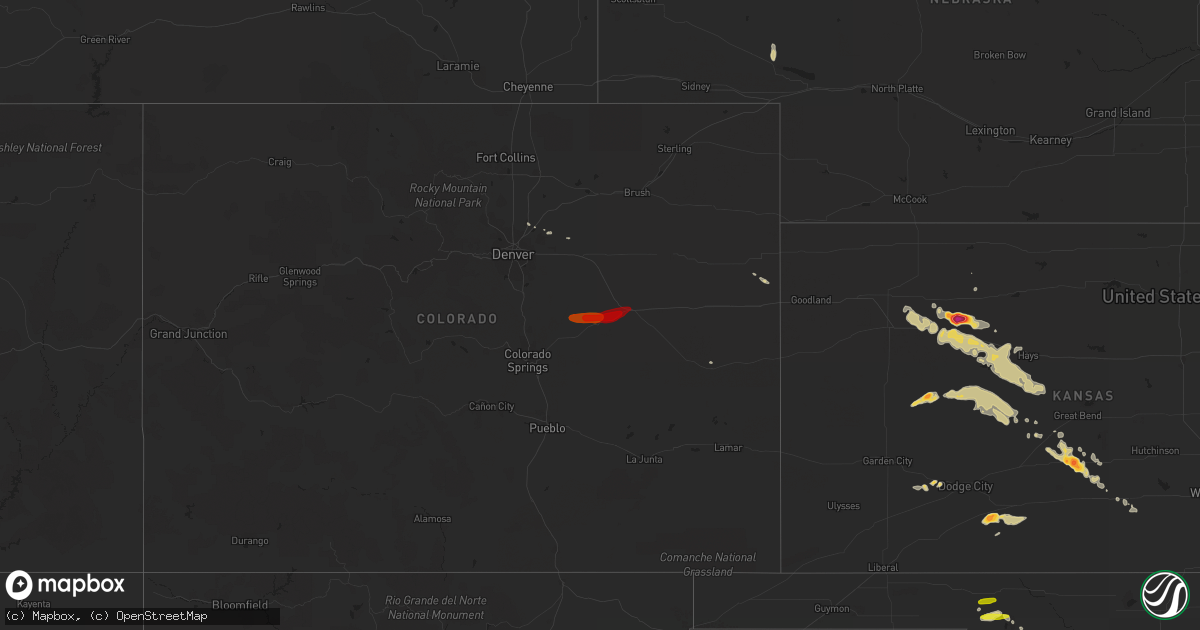
Hail Map on May 7, 2013
Get this storm
May 7 map
$229
one time, instant access
Download today. No call, no setup
Keep the $229
Bought the map and want the full workflow? Apply the entire $229 to a subscription within 7 days. None of it is wasted.
Every map, not just this one
This buys you this map. Subscription and you get every map we run, in the markets you choose from a few cities to whole states to nationwide. Plus real-time alerts the moment a storm fires.
Contact data
Name, contact info, occupancy, even credit band for addresses in the footprint. You go from where it hit to who to call.
Become the source they trust
Unlimited branding weather history reports on demand. You already have the documented answer ready for the property owner, and you are the one who showed up with it.
Property data and RoofTrace estimates
Pull up any address you have got, its value and the exact code rules for that jurisdiction, straight from One Click Code. Then RoofTrace estimates the squares, pitch, and roof value, priced the way you price.
Storm reports
Oklahoma
| Date | Description |
|---|---|
| 05/06/201310:10 PM CDT | A local report indicates 68 MPH wind near 7 WNW SEILING |
| 05/06/20137:04 PM CDT | A local report indicates 1.00 inch wind near 4 NE LAVERNE |
Kansas
| Date | Description |
|---|---|
| 05/07/20136:57 PM CDT | They received a measured 1.05 inches of rain. |
| 05/07/20136:45 PM CDT | A local report indicates 1.25 inch wind near 7 S UTICA |
| 05/07/20136:40 PM CDT | A local report indicates 1.00 inch wind near LENORA |
| 05/07/20136:40 PM CDT | The storm spotter reports quarter to ping pong ball size hail was soft like slushballs. |
| 05/07/20136:25 PM CDT | A local report indicates 1.75 inch wind near 4 ESE KINGSDOWN |
| 05/07/20135:45 PM CDT | A local report indicates 1.75 inch wind near 3 N DIGHTON |
| 05/07/20135:33 PM CDT | A local report indicates 1.75 inch wind near 6 ENE AMY |
| 05/07/20135:33 PM CDT | A local report indicates 1.00 inch wind near 4 ENE AMY |
| 05/07/20135:22 PM CDT | A local report indicates 1.00 inch wind near 7 SW DIGHTON |
| 05/06/201311:53 PM CDT | Powerlines and homes damaged northwest of great bend. Mass power outage as well. |
| 05/06/201310:30 PM CDT | A local report indicates 2.00 inch wind near 2 ESE DILLWYN |
| 05/06/20139:49 PM CDT | A local report indicates 1.00 inch wind near 4 NNE CEDAR BLUFF |
| 05/06/20139:40 PM CDT | The hail was mostly dime to nickel size. |
| 05/06/20139:23 PM CDT | A local report indicates 1.00 inch wind near WAKEENEY |
| 05/06/20139:13 PM CDT | A local report indicates 1.00 inch wind near 4 ESE VODA |
| 05/06/20139:12 PM CDT | A local report indicates 1.25 inch wind near ROZEL |
| 05/06/20138:30 PM CDT | A local report indicates 1.00 inch wind near 9 NNW BURDETT |
| 05/06/20138:15 PM CDT | Soft/slushy hail. Time estimated from radar. |
| 05/06/20137:40 PM CDT | Delayed report from last evening. Time estimated from doppler radar. |
| 05/06/20137:40 PM CDT | The hail was soft |
| 05/06/20137:35 PM CDT | A local report indicates 1.00 inch wind near DODGE CITY |
| 05/06/20137:30 PM CDT | Quarter size hail was falling on the north side of dodge city. |
| 05/06/20137:30 PM CDT | The hail covered the ground from pea to quarter size and 2.05 inches of rain fell in 40 minutes. |
| 05/06/20137:10 PM CDT | A local report indicates 1.00 inch wind near ELLIS |
Virginia
| Date | Description |
|---|---|
| 05/07/20133:08 PM CDT | Quarter size hail reported on route 890 between south of figsboro. |
| 05/07/20132:50 PM CDT | Reported at the fieldale cafe on marshall way |
| 05/07/20132:06 PM CDT | Quarter size hail |
| 05/07/20132:02 PM CDT | Quarter size hail |
Texas
| Date | Description |
|---|---|
| 05/06/20139:30 PM CDT | Reports of quater hail mixed with some smaller hail just west of snyder at fm 1609 and w 37th. Hail covering roadway. |
| 05/06/20138:00 PM CDT | Sheriffs office reports 1 inch hail mixed with smaller hail. |
Cities Impacted by Hail Map on May 7, 2013
- Hoxie, KS
- Morland, KS
- Wakeeney, KS
- Hill City, KS
- Bucklin, KS
- Ford, KS
- Minneola, KS
- Dighton, KS
- Healy, KS
- Fluvanna, TX
- Snyder, TX
- Macksville, KS
- Gail, TX
- Arrington, VA
- Wingina, VA
- Gladstone, VA
- Norwood, VA
- Shipman, VA
- St John, KS
- Quinter, KS
- Collyer, KS
- McCracken, KS
- Ogallah, KS
- Hays, KS
- Ellis, KS
- Ransom, KS
- Ness City, KS
- Alexander, KS
- Brownell, KS
- Utica, KS
- Bazine, KS
- Beeler, KS
- Burdett, KS
- Nekoma, KS
- Rush Center, KS
- Turon, KS
- Cunningham, KS
- Kingman, KS
- Post, TX
- Larned, KS
- Stafford, KS
- Laverne, OK
- May, OK
- Fargo, OK
- Park, KS
- Grainfield, KS
- Henrico, VA
- Glen Allen, VA
- Rozel, KS
- Mullinville, KS
- Haviland, KS
- Lewellen, NE
- Ingalls, KS
- Chester, OK
- Cimarron, KS
- Burlington, CO
- Buffalo, OK
- Fort Supply, OK
- Brighton, CO
- Seiling, OK
- Woodward, OK
- Pawnee Rock, KS
- Hudson, CO
- Bumpass, VA
- Mineral, VA
- Idalia, CO
- Oakley, KS
- Colby, KS
- Bingham, NE
- Gordon, NE
- Liebenthal, KS
- La Crosse, KS
- Bison, KS
- Selden, KS
- Richmond, VA
- Ira, TX
- Montpelier, VA
- Montezuma, KS
- Schoenchen, KS
- Crawford, NE
- Bennett, CO
- Ramah, CO
- Simla, CO
- Elbert, CO
- Calhan, CO
- Matheson, CO
- Agate, CO
- Limon, CO