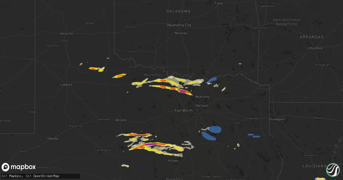
Hail Map on May 4, 2023
Get this storm
May 4 map
$229
one time, instant access
Download today. No call, no setup
Keep the $229
Bought the map and want the full workflow? Apply the entire $229 to a subscription within 7 days. None of it is wasted.
Every map, not just this one
This buys you this map. Subscription and you get every map we run, in the markets you choose from a few cities to whole states to nationwide. Plus real-time alerts the moment a storm fires.
Contact data
Name, contact info, occupancy, even credit band for addresses in the footprint. You go from where it hit to who to call.
Become the source they trust
Unlimited branding weather history reports on demand. You already have the documented answer ready for the property owner, and you are the one who showed up with it.
Property data and RoofTrace estimates
Pull up any address you have got, its value and the exact code rules for that jurisdiction, straight from One Click Code. Then RoofTrace estimates the squares, pitch, and roof value, priced the way you price.
States Impacted by Hail Map on May 4, 2023
Storm reports
Texas
| Date | Description |
|---|---|
| 05/04/20236:43 PM CDT | Delayed report: downed tree limbs. Trampoline and charcoal grill blown around. |
| 05/04/20236:43 PM CDT | A local report indicates 1.00 inch wind near 7 WNW OWENS |
| 05/04/20236:16 PM CDT | Strong thunderstorm winds damaged |
| 05/04/20235:47 PM CDT | West texas mesonet site recorded a 68 mph gust. |
| 05/04/20234:55 PM CDT | A local report indicates 63 MPH wind near 3 NW SEYMOUR |
| 05/04/20234:55 PM CDT | Powerlines down. |
| 05/04/20234:34 PM CDT | Video on twitter; time estimated from radar. |
| 05/04/202312:58 AM CDT | Widespread reports of trees and power lines down across nacogdoches co. This includes nacogdoches proper... As well as many locations on the north end of the county. |
| 05/04/202312:55 AM CDT | Numerous trees and power lines were downed throughout the city of nacogdoches. |
| 05/04/202312:48 AM CDT | A tree was downed in the brachfield community. |
| 05/04/202312:25 AM CDT | A tree was downed in reklaw. |
| 05/04/202312:19 AM CDT | Large limbs were downed in rusk. Portions of the city are without power. |
| 05/04/202312:14 AM CDT | Law enforcement reports scattered trees down across the county. No reports of power lines or structural damage. |
| 05/04/202312:05 AM CDT | A power line was downed on ragsdale street in jacksonville. |
| 05/03/202311:45 PM CDT | Tree and roof damage was reported in the frankston area. |
| 05/03/20239:49 PM CDT | Time estimated via radar. |
| 05/03/20239:48 PM CDT | Ping pong size hail resulting in vehicle dents when traveling north on highway 83 near the town of las colonias. Time estimated via radar. |
| 05/03/20239:46 PM CDT | Destroyed vehicle windshields and windows from hail up to baseball size. Time estimated via radar. |
| 05/03/20239:38 PM CDT | Golf ball size hail 6w sanger. |
| 05/03/20239:17 PM CDT | Half dollar size hail 5e slidell. Trees shredded. |
| 05/03/20239:16 PM CDT | Up to tennis ball size hail reported near the flying t o ranch airport in western zavala county. |
| 05/03/20239:13 PM CDT | Half dollar size hail covering ground 3e slidell. |
| 05/03/20239:13 PM CDT | 67 mph gust measured on sh-289 half-mile south of us 82 west of sherman. |
| 05/03/20238:51 PM CDT | Broadcast media relayed report of measured wind near whitesboro. |
| 05/03/20238:28 PM CDT | 60 mph estimated winds on fm1202 north of gainesville. |
| 05/03/20237:38 PM CDT | 2 inch hail 3s democrat. |
| 05/03/20237:28 PM CDT | Quarter size hail between zephyr and democrat. |
| 05/03/20237:05 PM CDT | Powerlines down. Tree damage. Time estimated based on radar. |
Utah
| Date | Description |
|---|---|
| 05/04/20235:10 PM CDT | I-80 at mile post 29. |
| 05/04/20233:40 PM CDT | Simpson springs mesonet site. |
| 05/03/20237:45 PM CDT | Vernon hill mesonet site. |
Kansas
| Date | Description |
|---|---|
| 05/03/20239:09 PM CDT | Off-duty nws employee reported cone tornado in progress. |
| 05/03/20237:08 PM CDT | Time estimated from radar. |
California
| Date | Description |
|---|---|
| 05/04/202310:56 AM CDT | A second tornado occurred in the los angeles area this morning. A weak tornado developed in compton near the intersection of greenleaf blvd. And s. Santa fe ave. Video |
| 05/04/202310:56 AM CDT | Corrects end-point intersection of previous tornado report from 1 se compton. A second tornado occurred in the los angeles area this morning. A weak tornado developed i |
| 05/04/202310:45 AM CDT | Updates information from previous tornado report from 2 wsw compton. This was the first of two tornadoes in the los angeles area from this morning. Brief weak tornado o |
| 05/04/202310:45 AM CDT | Brief weak tornado occurred this morning based on photographic and video evidence in the carson-compton area. Concentrated short path of minor damage to a couple of bui |
Colorado
| Date | Description |
|---|---|
| 05/04/20234:33 PM CDT | Corrects previous non-tstm wnd gst report from 2 sse centennial. Asos station kapa centennial airport. |
Idaho
| Date | Description |
|---|---|
| 05/04/20236:30 PM CDT | Mesonet station svb 2.4 sw ketchum |
| 05/04/20236:00 PM CDT | Mesonet station rwm inl radioactive waste mgmt. |
| 05/04/20236:00 PM CDT | Mesonet station 690 inl central facilities. |
| 05/04/20235:40 PM CDT | Mesonet station sum big southern butte. |
| 05/04/20233:45 PM CDT | Malta agrimet mali. |
Nevada
| Date | Description |
|---|---|
| 05/04/20235:11 PM CDT | I-80 pilot station... Pprnv. Elevation 4651 feet. |
| 05/04/20234:42 PM CDT | Antelope lake raws... Alrn2. Elevation 5460 feet. |
Nebraska
| Date | Description |
|---|---|
| 05/03/20238:10 PM CDT | Public reported lots of small hail of penny to nickel sized with some quarter sized hail mixed in. |
Wyoming
| Date | Description |
|---|---|
| 05/03/20237:24 PM CDT | Asos station klnd lander airport. |
Washington
| Date | Description |
|---|---|
| 05/03/20238:30 PM CDT | A couple of social media reports of strong winds and minor damage to trees and property near and north of curlew. Time and location estimated based on radar. |
Cities Impacted by Hail Map on May 4, 2023
- Canistota, SD
- Montrose, SD
- Humboldt, SD
- Walters, OK
- Frederick, OK
- Loveland, OK
- Davidson, OK
- Salem, SD
- Lockney, TX
- Matador, TX
- Seymour, TX
- Crowell, TX
- Del Rio, TX
- Comstock, TX
- Paducah, TX
- Holliday, TX
- Coleman, TX
- Winters, TX
- Anton, CO
- Childress, TX
- Lagrange, WY
- Burkett, TX
- Rockwood, TX
- Gouldbusk, TX
- Santa Anna, TX
- Brookesmith, TX
- Wichita Falls, TX
- Henrietta, TX
- Cross Plains, TX
- Brownwood, TX
- May, TX
- Windthorst, TX
- Sidney, TX
- Comanche, TX
- Early, TX
- Zephyr, TX
- Bangs, TX
- Bellevue, TX
- Richfield, KS
- Mullin, TX
- Nocona, TX
- Bowie, TX
- Montague, TX
- Hugoton, KS
- Utica, KS
- Dighton, KS
- Blanket, TX
- Priddy, TX
- Goldthwaite, TX
- Hamilton, TX
- Pottsville, TX
- Beeler, KS
- Saint Jo, TX
- Muenster, TX
- Sunset, TX
- Tryon, NE
- Sutherland, NE
- Forestburg, TX
- Gainesville, TX
- Alvord, TX
- Burwell, NE
- Bassett, NE
- Jonesboro, TX
- Quemado, TX
- Decatur, TX
- Whitesboro, TX
- Eagle Pass, TX
- Sanger, TX
- Crystal City, TX
- Krum, TX
- Gatesville, TX
- Valley Mills, TX
- Lometa, TX
- Star, TX
- Sherman, TX
- Denison, TX
- Pottsboro, TX
- Evant, TX
- Bells, TX
- Denton, TX
- Aubrey, TX
- Pilot Point, TX
- Crawford, TX
- Savoy, TX
- Ravenna, TX
- Hendrix, OK
- Oglesby, TX
- McGregor, TX
- Carrizo Springs, TX
- Ivanhoe, TX
- Big Wells, TX
- Telephone, TX
- Compton, CA
- Powell, TX
- Corsicana, TX
- Rice, TX
- Kerens, TX
- Trinidad, TX
- Mabank, TX
- Kemp, TX
- Purdon, TX
- Barry, TX
- Wortham, TX
- Richland, TX
- Dawson, TX
- Mexia, TX
- Streetman, TX
- Long Beach, CA
- Carson, CA
- Weskan, KS
- Centerville, SD
- Bayard, NE
- Gurley, NE
- Lindsay, TX
- Lake Andes, SD
- Rising Star, TX
- Brady, TX
- Hext, TX
- Mason, TX
- Ringgold, TX
- Beresford, SD
- Winona, KS
- Leoti, KS
- Vermillion, SD
- Burbank, SD
- Novice, TX
- Tonasket, WA
- Prairie City, OR
- Stuart, NE
- Healy, KS
- Weinert, TX
- Atkinson, NE
- Laurel, NE
- Newcastle, NE
- Geddes, SD
- Dublin, TX
- Gustine, TX
- Lohn, TX
- Ness City, KS
- Valera, TX
- Bethune, CO
- Burlington, CO
- Talpa, TX
- Rosston, TX
- Thackerville, OK
- Eustace, TX
- Athens, TX
- Malakoff, TX
- Fairfield, TX
- Laneville, TX
- Mount Enterprise, TX
- Long Branch, TX
- Garrison, TX
- Timpson, TX
- Grapeland, TX
- Mason City, NE
- Crofton, NE
- Windom, TX
- Honey Grove, TX
- Bonham, TX
- Dodd City, TX
- Paxton, NE
- Ansley, NE
- Ector, TX
- Era, TX
- Valley View, TX
- West, TX
- Waco, TX
- Aquilla, TX
- China Spring, TX
- Elm Mott, TX
- Cooper, TX
- Pecan Gap, TX
- Woodway, TX
- Sadler, TX
- Ben Franklin, TX
- Roxton, TX
- Ladonia, TX
- Enders, NE
- Wauneta, NE
- Elkhart, TX
- Howe, TX
- Elsie, NE
- Rusk, TX
- Moody, TX
- Copperas Cove, TX
- Lampasas, TX
- Riesel, TX
- Mart, TX
- Frost, TX
- Blooming Grove, TX
- Collinsville, TX
- Alto, TX
- Fort Hood, TX
- Purmela, TX
- Plaquemine, LA
- Addis, LA
- Grosse Tete, LA
- Sunshine, LA
- Saint Gabriel, LA
- Geismar, LA
- Baton Rouge, LA
- Port Allen, LA
- Gonzales, LA
- Prairieville, LA
- Arnaudville, LA
- Church Point, LA
- Opelousas, LA
- Port Barre, LA
- Sunset, LA
- Rattan, OK
- Denham Springs, LA
- Gray, LA
- Thibodaux, LA
- Morgan City, LA
- Gibson, LA
- Donner, LA
- Schriever, LA
- Raceland, LA
- Livingston, LA
- Theriot, LA
- Saint Amant, LA
- Maurepas, LA
- French Settlement, LA