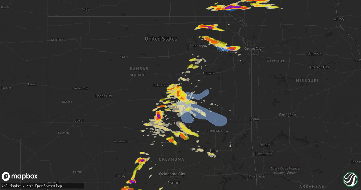
Hail Map on April 30, 2024
Get this storm
April 30 map
$229
one time, instant access
Download today. No call, no setup
Keep the $229
Bought the map and want the full workflow? Apply the entire $229 to a subscription within 7 days. None of it is wasted.
Every map, not just this one
This buys you this map. Subscription and you get every map we run, in the markets you choose from a few cities to whole states to nationwide. Plus real-time alerts the moment a storm fires.
Contact data
Name, contact info, occupancy, even credit band for addresses in the footprint. You go from where it hit to who to call.
Become the source they trust
Unlimited branding weather history reports on demand. You already have the documented answer ready for the property owner, and you are the one who showed up with it.
Property data and RoofTrace estimates
Pull up any address you have got, its value and the exact code rules for that jurisdiction, straight from One Click Code. Then RoofTrace estimates the squares, pitch, and roof value, priced the way you price.
States Impacted by Hail Map on April 30, 2024
Storm reports
Oklahoma
| Date | Description |
|---|---|
| 04/30/20245:48 PM CDT | Report from mping: half dollar |
| 04/30/20245:45 PM CDT | Digital caliper measurement. Radar estimated time. |
| 04/30/20245:45 PM CDT | Digital caliper measurement. Radar estimated time. |
| 04/30/20245:44 PM CDT | A local report indicates 3.00 inch wind near 4 WSW Cloud Chief |
| 04/30/20245:31 PM CDT | Report from mping: tennis ball |
| 04/30/20245:30 PM CDT | Multiple visual reports. Damage reported in cordell. Additional details pending. Radar estimated time. |
| 04/30/20245:25 PM CDT | Report from mping: golf ball |
| 04/30/20245:24 PM CDT | Report from mping: quarter |
| 04/30/20245:21 PM CDT | Report from mping: quarter |
| 04/30/20245:19 PM CDT | Report from mping: golf ball |
| 04/30/20245:11 PM CDT | A local report indicates 1.00 inch wind near Kremlin |
| 04/30/20244:35 PM CDT | Relayed image. Radar estimated time. |
| 04/30/20244:35 PM CDT | Relayed im |
| 04/30/20244:27 PM CDT | Phone call report. |
| 04/30/20244:23 PM CDT | Report from mping: half dollar |
| 04/30/20244:22 PM CDT | Phone call report. |
| 04/30/20243:55 PM CDT | Report from mping: half dollar |
| 04/30/20246:00 AM CDT | A local report indicates 1.00 inch wind near Chickasha |
| 04/30/20244:36 AM CDT | A local report indicates 1.00 inch wind near Hitchcock |
| 04/30/202412:00 AM CDT | Ringling mesonet. |
| 04/29/202411:10 PM CDT | Grandfield mesonet. |
| 04/29/202410:50 PM CDT | Social media image showing a tree uprooted. Radar estimated time. |
| 04/29/202410:45 PM CDT | Grandfield mesonet. |
| 04/29/202410:32 PM CDT | Report from mping: quarter |
| 04/29/202410:21 PM CDT | Tds noted. Additional details pending. |
| 04/29/202410:20 PM CDT | Damage to fence and roof partially removed from barn. Also occasional tree damage. |
| 04/29/202410:15 PM CDT | A local report indicates 1.75 inch wind near Manitou |
| 04/29/20249:42 PM CDT | Tds noted along with visual confirmation. Additional details pending. |
| 04/29/20249:33 PM CDT | Kfdr. |
| 04/29/20249:28 PM CDT | Report from mping: half dollar |
| 04/29/20248:56 PM CDT | A local report indicates 1.75 inch wind near Manitou |
| 04/29/20248:45 PM CDT | Report from mping: golf ball |
| 04/29/20248:35 PM CDT | Medford mesonet. |
| 04/29/20248:20 PM CDT | Social media image. |
| 04/29/20248:12 PM CDT | A local report indicates 1.50 inch wind near Frederick |
| 04/29/20248:11 PM CDT | A local report indicates 1.00 inch wind near 1 W Frederick |
| 04/29/20248:08 PM CDT | Report from mping: quarter |
| 04/29/20247:58 PM CDT | 1.9 inch diameter hail reported by trained storm spotter. |
| 04/29/20247:35 PM CDT | Multiple social media images. Additional details pending. Radar estimated time. |
| 04/29/20247:19 PM CDT | A local report indicates 1.00 inch wind near Manitou |
South Carolina
| Date | Description |
|---|---|
| 04/29/20248:58 PM CDT | Quarter size hail reported by the public near ehrhardt rd and pocketville rd... Nw of ehrhardt. Time estimated. |
Texas
| Date | Description |
|---|---|
| 04/30/20246:33 PM CDT | Report from mping: quarter |
| 04/30/20246:25 PM CDT | Picture of hail with quarter for reference. Spotter measured ping pong ball size. |
| 04/30/20246:22 PM CDT | Possibly as big as baseballs. Skylights and windows busted out in westbrook. |
| 04/30/20246:06 PM CDT | Photos and video of hail and broken windshields. |
| 04/30/20244:20 PM CDT | Reports broken windshields and ground covered with hail. |
Missouri
| Date | Description |
|---|---|
| 04/30/20246:35 PM CDT | Golf ball sized hail reported by emergency manager. |
| 04/30/20246:35 PM CDT | Emergency manager reports golf ball sized hail 5 miles south of maryville. |
| 04/30/20246:32 PM CDT | Social media report of ping pong ball size hail northwest of barnard. Time estimated from radar. |
| 04/30/20246:26 PM CDT | Public reported baseball-sized hail on social media. |
| 04/30/20246:14 PM CDT | Social media report of hail near tennis ball size southwest of maryville. Time and location estimated from radar and social media report. |
| 04/30/20246:12 PM CDT | Emergency manager reported quarter sized hail. |
| 04/30/20246:00 PM CDT | Public posted picture of 3 inch sized hail. |
| 04/30/20245:57 PM CDT | Social media report of baseball size hail north of mound city. Vehicle with broken windshield. Time and location estimated using radar and social media report. |
| 04/30/20245:41 PM CDT | Law enforcement reported 60-70 mph wind gusts. |
| 04/30/20245:41 PM CDT | Golf ball-sized hail reported by law enforcement. |
| 04/30/20245:36 PM CDT | Significant damage to police patrol car. |
| 04/30/20245:29 PM CDT | Private weather station reported a 65 mph gust at 529 pm. |
| 04/29/20248:54 PM CDT | Emergency manager reported 58mph gust on bethany high school automated station-. |
| 04/29/20248:54 PM CDT | Emergency manager reported 58mph gust on bethany high s |
| 04/29/20248:00 PM CDT | Emergency manager reported ping pong ball size hail. |
| 04/29/20248:00 PM CDT | Delayed social media report of golf ball size hail in gentry. Time estimated from radar. |
| 04/29/20247:58 PM CDT | Storm spotters reported ping pong-sized hail. |
| 04/29/20247:56 PM CDT | Emergency manager reported quarter-sized hail in hatfield... Mo. |
| 04/29/20247:48 PM CDT | Public reported golf ball-sized hail. |
| 04/29/20247:42 PM CDT | Golf ball-sized hail reported by emergency manager. |
| 04/29/20247:37 PM CDT | Social media reported quarter-sized hail. |
| 04/29/20247:22 PM CDT | Emergency manager reported hail in worth county. Occasional ping pong ball size. |
| 04/29/20247:20 PM CDT | Emergency manager reported golf ball-sized hail. |
Nebraska
| Date | Description |
|---|---|
| 04/30/20245:05 PM CDT | A local report indicates 1.75 inch wind near Stella |
| 04/30/20244:52 PM CDT | Quarter |
| 04/30/20244:50 PM CDT | A local report indicates 1.00 inch wind near 4 NE Julian |
| 04/30/20244:31 PM CDT | A local report indicates 1.00 inch wind near 6 E Elk Creek |
| 04/30/20243:32 PM CDT | A local report indicates 1.25 inch wind near Herman |
| 04/30/20243:01 PM CDT | A local report indicates 1.00 inch wind near 2 E Hartington |
| 04/30/20242:51 PM CDT | A local report indicates 1.00 inch wind near 3 N Ames |
| 04/30/20242:40 PM CDT | Quarter |
Iowa
| Date | Description |
|---|---|
| 04/30/20246:48 PM CDT | Em relayed image of quarter sized hail just north of garden grove. Time estimated from radar. |
| 04/30/20246:43 PM CDT | Near green valley lake. |
| 04/30/20246:43 PM CDT | Up to quarter sized hail. |
| 04/30/20246:43 PM CDT | Variety of change hail. Biggest size is quarters. |
| 04/30/20246:38 PM CDT | Up to quarter sized hail. |
| 04/30/20246:38 PM CDT | Spotter relayed hail up to 1 inch in size just west of i-35 between osceola and truro. Copious amounts of hail overall. Time estimated from radar. |
| 04/30/20246:28 PM CDT | Spotter relayed copious amounts of hail... Up to quarter in size. Just west of i-35 between osceola and truro. Location and time estimated from radar. |
| 04/30/20246:24 PM CDT | Report from mping: quarter |
| 04/30/20246:20 PM CDT | Report from mping: half dollar |
| 04/30/20246:18 PM CDT | Up to quarter sized hail near east county line. |
| 04/30/20246:15 PM CDT | Photo from who tv viewer. |
| 04/30/20246:13 PM CDT | Report from mping: half dollar |
| 04/30/20246:12 PM CDT | Delayed report by trained spotter... Measured up to 1.75 inch hail stones. Shredded leaves. |
| 04/30/20246:11 PM CDT | A local report indicates 1.00 inch wind near Lorimor |
| 04/30/20246:08 PM CDT | Relayed by broadcast meteorologist. Delayed report... Time estimated by radar. |
| 04/30/20246:05 PM CDT | A local report indicates 1.00 inch wind near Rippey |
| 04/30/20246:03 PM CDT | Near rea rd and creamery rd. Time estimated from radar. |
| 04/30/20246:03 PM CDT | A local report indicates 1.00 inch wind near 1 S Truro |
| 04/30/20245:57 PM CDT | Storm inflow gust on personal weather station. |
| 04/30/20245:54 PM CDT | Trees in road. |
| 04/30/20245:51 PM CDT | A local report indicates 1.00 inch wind near Bagley |
| 04/30/20245:40 PM CDT | Report from mping: ping pong ball |
| 04/30/20245:33 PM CDT | Nickel to quarter sized hail. |
| 04/30/20245:28 PM CDT | Damage to trees and damage to house. Time estimated by radar. |
| 04/30/20245:24 PM CDT | A local report indicates 1.00 inch wind near 3 WNW Orient |
| 04/30/20245:22 PM CDT | A local report indicates 1.00 inch wind near 2 ESE Orient |
| 04/30/20245:21 PM CDT | A local report indicates 1.00 inch wind near 5 SE Riverton |
| 04/30/20244:59 PM CDT | A local report indicates 1.00 inch wind near 3 S Bridgewater |
| 04/30/20244:38 PM CDT | Up to quarter sized hail. |
| 04/30/20244:37 PM CDT | Delayed report. |
| 04/30/20244:26 PM CDT | A local report indicates 1.00 inch wind near 1 NNE Grant |
| 04/30/20244:13 PM CDT | Personal weather station. |
| 04/30/20244:05 PM CDT | A local report indicates 1.75 inch wind near Elliott |
| 04/30/20244:04 PM CDT | A local report indicates 1.00 inch wind near 6 S Granville |
| 04/30/20243:47 PM CDT | A local report indicates 2.25 inch wind near Malvern |
| 04/30/20243:33 PM CDT | Corrects previous hail report from malvern. Time based on radar. |
| 04/30/20243:33 PM CDT | A local report indicates 1.75 inch wind near Malvern |
| 04/30/20243:25 PM CDT | A local report indicates 1.75 inch wind near 4 ESE Glenwood |
| 04/30/20243:25 PM CDT | Dot automated station. |
| 04/30/20243:24 PM CDT | A local report indicates 1.00 inch wind near 2 SE Malvern |
| 04/29/20248:30 PM CDT | A local report indicates 1.00 inch wind near 2 E Melrose |
| 04/29/20247:50 PM CDT | Delayed report - social media picture of hail north of centerville. |
| 04/29/20247:35 PM CDT | Rathbun lake - appanoose co 911. |
| 04/29/20247:28 PM CDT | Delayed report via social media. |
| 04/29/20247:20 PM CDT | Suspected brief tornado near millerton with damage |
Montana
| Date | Description |
|---|---|
| 04/30/20244:45 PM CDT | Convective outflow wind gust to 62 mph. Sustained wind near 49 mph. Mesonet station gw3478 tctiber. |
| 04/30/20244:30 PM CDT | Convective outflow wind gust. Mesonet station gw3478 tctiber. |
Pennsylvania
| Date | Description |
|---|---|
| 04/30/20246:58 PM CDT | A few trees reported down across plainfield township. Some power outages and cell phone reception outages in the area. Time estimated from radar. |
| 04/30/20246:55 PM CDT | Updates previous hail report from north catasauqua. 16 minutes of dime to quarter sized hail in north catasauqua. Hail briefly grew to half dollar size. Time estimated |
| 04/30/20246:55 PM CDT | 16 minutes of dime to quarter sized hail in north catasauqua. Time estimated from radar. |
| 04/30/20246:53 PM CDT | A local report indicates 1.00 inch wind near Whitehall Twp |
| 04/30/20246:52 PM CDT | Trained spotter reports max hail size of 1.25 inches fell from 7:52-7:56pm. |
| 04/30/20246:50 PM CDT | Report from mping: quarter |
| 04/30/20246:49 PM CDT | A few trees reported down across moore township. Power outages in the area as well. Time estimated from radar. |
| 04/30/20246:45 PM CDT | Report from cocorahs station schnecksville 1.7 ene. |
| 04/30/20246:35 PM CDT | Updates previous hail report in slatington. |
| 04/30/20241:52 PM CDT | Tree down blocking roadway. Time estimated from radar. |
| 04/30/20241:52 PM CDT | A local report indicates 1.00 inch wind near Harford |
| 04/30/20241:25 PM CDT | Tree down. Time estimated from radar. |
| 04/30/20241:25 PM CDT | A local report indicates 1.00 inch wind near Montrose |
Kansas
| Date | Description |
|---|---|
| 04/30/20246:58 PM CDT | Report from mping: 3-inch tree limbs broken; power poles broken. Time estimated from radar data. |
| 04/30/20246:56 PM CDT | Social media report. |
| 04/30/20246:54 PM CDT | Estimated 70-80 mph winds. |
| 04/30/20246:49 PM CDT | Estimated 60 mph winds in derby. Delayed report. Time estimated by radar. |
| 04/30/20246:48 PM CDT | 12-14 inch diameter limb down and another 8-inch diameter tree down. |
| 04/30/20246:46 PM CDT | A local report indicates a tornado near 2 NW Grantville |
| 04/30/20246:45 PM CDT | A local report indicates 86 MPH wind near 3 ENE Topeka |
| 04/30/20246:45 PM CDT | A local report indicates 65 MPH wind near 3 NNW Topeka |
| 04/30/20246:43 PM CDT | A local report indicates 72 MPH wind near 3 NE Topeka |
| 04/30/20246:42 PM CDT | Destroyed barn doors... Multiple trees down... Shingles uplifted. Between highway 24 and 31st st. |
| 04/30/20246:40 PM CDT | Delayed report. Time estimated by radar. |
| 04/30/20246:40 PM CDT | A local report indicates 1.75 inch wind near Andover |
| 04/30/20246:39 PM CDT | Delayed report. Several trees uprooted or snapped and blown to the east along k4 highway between 35th and 39th street. Time estimated from radar. |
| 04/30/20246:35 PM CDT | Quarter size hail. Time estimated from radar. |
| 04/30/20246:35 PM CDT | A local report indicates 65 MPH wind near 1 WSW El Dorado |
| 04/30/20246:34 PM CDT | Delayed report. Several trees damaged and uprooted along meriden road... Blown down to the east. Damage to a fence also. Time estimated from radar. |
| 04/30/20246:34 PM CDT | A local report indicates 1.00 inch wind near 1 WSW El Dorado |
| 04/30/20246:33 PM CDT | Power pole down. |
| 04/30/20246:32 PM CDT | Delayed report. Several tree limbs down in excess of 10 inches in diameter. Time estimated by radar. |
| 04/30/20246:32 PM CDT | A local report indicates 1.00 inch wind near Andover |
| 04/30/20246:30 PM CDT | A local report indicates 1.00 inch wind near Clearwater |
| 04/30/20246:30 PM CDT | A local report indicates 1.00 inch wind near 1 ESE East Wichita |
| 04/30/20246:19 PM CDT | A local report indicates 1.75 inch wind near Norwich |
| 04/30/20246:18 PM CDT | A local report indicates 1.00 inch wind near Norwich |
| 04/30/20246:14 PM CDT | A local report indicates 1.00 inch wind near 1 WNW Benton |
| 04/30/20246:05 PM CDT | Quarter sized hail with up to 50 mph winds. |
| 04/30/20246:02 PM CDT | A local report indicates 1.50 inch wind near Park City |
| 04/30/20245:58 PM CDT | A local report indicates 1.75 inch wind near 3 N Kechi |
| 04/30/20245:57 PM CDT | A local report indicates 1.00 inch wind near 4 S Whitewater |
| 04/30/20245:56 PM CDT | A local report indicates 1.00 inch wind near 2 W Whitewater |
| 04/30/20245:43 PM CDT | A local report indicates 1.00 inch wind near Colwich |
| 04/30/20245:41 PM CDT | A local report indicates 1.00 inch wind near 4 E Wilsey |
| 04/30/20245:40 PM CDT | Delayed report. Power poles down at 125th and meridian. Time estimated by radar. |
| 04/30/20245:37 PM CDT | Delayed report. Irrigation pivot blew onto the roadway at 60th and emma creek. Time estimated by radar. |
| 04/30/20245:34 PM CDT | Picture received via facebook. |
| 04/30/20245:34 PM CDT | A local report indicates 1.75 inch wind near 2 S Newton |
| 04/30/20245:31 PM CDT | A local report indicates 1.25 inch wind near 4 S Mt Vernon |
| 04/30/20245:17 PM CDT | Radar estimated with approx time from social media report. |
| 04/30/20245:11 PM CDT | A local report indicates 1.00 inch wind near 4 NW Burdick |
| 04/30/20245:11 PM CDT | A local report indicates 1.00 inch wind near Mount Hope |
| 04/30/20245:10 PM CDT | Tornado hit a house at this location. |
| 04/30/20245:04 PM CDT | Visual confirmation of tornado southeast of vermillion. |
| 04/30/20245:00 PM CDT | A local report indicates 1.00 inch wind near White City |
| 04/30/20244:52 PM CDT | A local report indicates 1.00 inch wind near 5 NW Halstead |
| 04/30/20244:41 PM CDT | Tornado reported near westmoreland. Damage to residential structures on the west side of westmoreland has been reported. |
| 04/30/20244:40 PM CDT | [landspout] multiple pictures of a landspout west of halstead. |
| 04/30/20244:28 PM CDT | A local report indicates 2.00 inch wind near 3 E Centralia |
| 04/30/20244:22 PM CDT | Estimated from photo. |
| 04/30/20244:17 PM CDT | A local report indicates 1.00 inch wind near 5 E Olsburg |
| 04/30/20244:08 PM CDT | Estimated from photo. Time estimated from radar. |
| 04/30/20243:58 PM CDT | A local report indicates 1.75 inch wind near Frankfort |
| 04/30/20243:50 PM CDT | Larger than golf ball size. |
| 04/29/20249:37 PM CDT | A local report indicates 60 MPH wind near Coffeyville Airport |
| 04/29/20249:36 PM CDT | Aso |
| 04/29/20249:36 PM CDT | Asos station kcfv coffeyville municipal airpt. |
| 04/29/20249:24 PM CDT | A local report indicates 60 MPH wind near 3 W Tyro |
| 04/29/20249:05 PM CDT | A local report indicates 60 MPH wind near 3 NW Tyro |
| 04/29/20248:41 PM CDT | Also had some limbs and trees down. |
| 04/29/20248:38 PM CDT | A local report indicates 70 MPH wind near 7 SW Winfield |
| 04/29/20248:33 PM CDT | Asos station kwld strother field airport. |
| 04/29/20248:22 PM CDT | Brief tornado touchdown that came in via social media. |
| 04/29/20248:14 PM CDT | Report from mping: trees uprooted or snapped; roof blown off. |
| 04/29/20248:13 PM CDT | Report from mping: 3-inch tree limbs broken; power poles broken. |
| 04/29/20248:08 PM CDT | Downed power lines and power outages near crest drive. Time estimated from radar. |
| 04/29/20248:05 PM CDT | Downed power lines and power outages near woodland drive. Time estimated from radar. |
| 04/29/20248:02 PM CDT | Report from mping: 1-inch tree limbs broken; shingles blown off. |
| 04/29/20248:00 PM CDT | Large tree down. Report came in via social media. |
| 04/29/20247:57 PM CDT | Report from mping: 1-inch tree limbs broken; shingles blown off. |
| 04/29/20247:57 PM CDT | Downed power lines and power outages near parallel parkway. Time estimated from radar. |
| 04/29/20247:50 PM CDT | Downed power lines and power outages near wolcott drive. Time estimated from radar. |
| 04/29/20247:46 PM CDT | A local report indicates 70 MPH wind near Burden |
| 04/29/20247:40 PM CDT | Downed power lines and power outages near hollingsworth road. Time estimated from radar. |
| 04/29/20247:29 PM CDT | Report from mping: quarter |
| 04/29/20247:25 PM CDT | Video of up to baseball size hail in anthony. Public call corroborates this video. Most of the hail is golf ball size. |
| 04/29/20247:16 PM CDT | A local report indicates 1.00 inch wind near 4 SW Mclouth |
| 04/29/20247:11 PM CDT | A local report indicates 1.75 inch wind near 3 E Williamstown |
| 04/29/20247:10 PM CDT | A local report indicates 1.50 inch wind near Anthony |
| 04/29/20247:09 PM CDT | A local report indicates 1.00 inch wind near 5 N Williamstown |
| 04/29/20247:08 PM CDT | Report from mping: 1-inch tree limbs broken; shingles blown off. |
| 04/29/20247:06 PM CDT | A local report indicates 2.00 inch wind near Williamstown |
| 04/29/20247:04 PM CDT | Rain wrapped tornado. |
| 04/29/20247:04 PM CDT | At lakeside village. |
| 04/29/20247:03 PM CDT | Report from mping: ping pong ball |
| 04/29/20247:03 PM CDT | Report from mping: quarter |
| 04/29/20247:02 PM CDT | A local report indicates 1.00 inch wind near Williamstown |
| 04/29/20247:01 PM CDT | Video sent via social media. |
| 04/29/20247:00 PM CDT | A local report indicates 1.00 inch wind near 2 E Harper |
Florida
| Date | Description |
|---|---|
| 04/30/20242:30 PM CDT | Steel gazebo was lifted into the air and damaged the gutter/and part of the roof of a home. |
| 04/30/20241:33 PM CDT | Power line blown down in holley. Verified by holley-navarre fire. |
Cities Impacted by Hail Map on April 30, 2024
- Clarkson, NE
- Leigh, NE
- Creston, NE
- Madison, NE
- Stanton, NE
- Pilger, NE
- Ballston Lake, NY
- Ballston Spa, NY
- Dodge, NE
- Howells, NE
- West Point, NE
- Saratoga Springs, NY
- Brewton, AL
- Andalusia, AL
- Elliott, IA
- Griswold, IA
- Cumberland, IA
- Massena, IA
- Montrose, PA
- Lawton, PA
- Westville, FL
- Bonifay, FL
- New Milford, PA
- Kingsley, PA
- Geneva, AL
- Harford, PA
- Susquehanna, PA
- Jackson, PA
- Thompson, PA
- Cooperstown, NY
- North Bend, NE
- Morse Bluff, NE
- Union Dale, PA
- Ames, NE
- Hooper, NE
- Cedar Bluffs, NE
- Scribner, NE
- Otoe, NE
- Nebraska City, NE
- Nehawka, NE
- Dunbar, NE
- Fremont, NE
- Blair, NE
- Nickerson, NE
- Arlington, NE
- Herman, NE
- Union, NE
- Modale, IA
- Missouri Valley, IA
- Thurman, IA
- Pacific Junction, IA
- Tabor, IA
- Glenwood, IA
- Malvern, IA
- Plattsmouth, NE
- Murray, NE
- Hartington, NE
- Craig, NE
- Mondamin, IA
- Hastings, IA
- Tekamah, NE
- Emerson, IA
- Blue Rapids, KS
- Frankfort, KS
- Pisgah, IA
- Logan, IA
- Woodbine, IA
- Little Sioux, IA
- Iraan, TX
- Moorhead, IA
- Dunlap, IA
- Fort Stockton, TX
- Henderson, IA
- Red Oak, IA
- Vermillion, KS
- Fay, OK
- Oakwood, OK
- Thomas, OK
- Le Mars, IA
- Mangum, OK
- Scranton, PA
- Remsen, IA
- Granite, OK
- Centralia, KS
- Steinauer, NE
- Elk Creek, NE
- Humboldt, NE
- Table Rock, NE
- Grant, IA
- Villisca, IA
- Watonga, OK
- Lewis, IA
- Carson, IA
- Oakland, IA
- Canton, OK
- Marysville, KS
- Home, KS
- Westmoreland, KS
- Olsburg, KS
- Lone Wolf, OK
- Auburn, NE
- Corning, IA
- Seneca, KS
- Westphalia, IA
- Earling, IA
- Panama, IA
- Portsmouth, IA
- Harlan, IA
- Custer City, OK
- Paullina, IA
- Marcus, IA
- Granville, IA
- Dill City, OK
- Corning, KS
- Nodaway, IA
- Onaga, KS
- Sentinel, OK
- Cordell, OK
- Goff, KS
- Kirkman, IA
- Irwin, IA
- Defiance, IA
- Manilla, IA
- Midkiff, TX
- Midland, TX
- Ringwood, OK
- Meno, OK
- Johnson, NE
- Halstead, KS
- Braddyville, IA
- Elmo, MO
- Ute, IA
- Burrton, KS
- Corn, OK
- Taloga, OK
- Ozona, TX
- Garden City, TX
- Hobart, OK
- White City, KS
- Sedgwick, KS
- Junction City, KS
- Mount Hope, KS
- Clarinda, IA
- Bedford, IA
- New Market, IA
- Peru, NE
- Bridgewater, IA
- Stella, NE
- Manning, IA
- Prescott, IA
- Fontanelle, IA
- Orient, IA
- Stanton, IA
- Haven, KS
- Shambaugh, IA
- Clearmont, MO
- Herington, KS
- Aspinwall, IA
- Greenfield, IA
- Clinton, OK
- Council Grove, KS
- Creston, IA
- Arapaho, OK
- Sabetha, KS
- Shubert, NE
- Nemaha, NE
- Newton, KS
- Gravity, IA
- Colwich, KS
- Weatherford, OK
- Peabody, KS
- Hillsboro, KS
- Dawson, NE
- Carroll, IA
- Arcadia, IA
- Halbur, IA
- Wamego, KS
- Jet, OK
- Audubon, IA
- Marion, KS
- Lost Springs, KS
- Rock Port, MO
- Hamburg, IA
- Merrill, IA
- Walton, KS
- Enid, OK
- Primghar, IA
- Sutherland, IA
- Burdick, KS
- Lincolnville, KS
- Wetmore, KS
- Kremlin, OK
- Bentley, KS
- Belvue, KS
- Saint Marys, KS
- Emmett, KS
- Delia, KS
- Soldier, KS
- Havensville, KS
- Geary, OK
- Murdock, KS
- Chillicothe, TX
- Vernon, TX
- Cheney, KS
- Wilsey, KS
- Paducah, TX
- Coon Rapids, IA
- Pond Creek, OK
- Nash, OK
- Sharpsburg, IA
- Clearfield, IA
- Riverton, IA
- Westboro, MO
- Alta Vista, KS
- Dwight, KS
- Templeton, IA
- Dedham, IA
- Gray, IA
- Falls City, NE
- Fairfax, MO
- Verdon, NE
- Quanah, TX
- Wiota, IA
- Scranton, IA
- Whitewater, KS
- Macksburg, IA
- Lorimor, IA
- Winterset, IA
- Big Spring, TX
- Maize, KS
- Valley Center, KS
- Garden Plain, KS
- Goddard, KS
- North Newton, KS
- Andale, KS
- Craig, MO
- Seymour, TX
- Kingman, KS
- Diagonal, IA
- Benton, IA
- Florence, KS
- Northboro, IA
- Shenandoah, IA
- Bayard, IA
- Afton, IA
- Viola, KS
- Milton, KS
- Wichita, KS
- Eldorado, OK
- Netawaka, KS
- Whiting, KS
- Mayetta, KS
- Hoyt, KS
- Rulo, NE
- Mound City, MO
- Maitland, MO
- Skidmore, MO
- Olustee, OK
- Gotebo, OK
- Jefferson, IA
- Bagley, IA
- Ellston, IA
- Tingley, IA
- Rossville, KS
- Coin, IA
- College Springs, IA
- Blanchard, IA
- Hiawatha, KS
- Peru, IA
- Silver Lake, KS
- Norwich, KS
- Kellerton, IA
- Mount Ayr, IA
- Topeka, KS
- Jamaica, IA
- Harper, KS
- Danville, KS
- Attica, KS
- Crowell, TX
- Benton, KS
- Kechi, KS
- Greenwich, KS
- Douglass, KS
- Coahoma, TX
- Westbrook, TX
- Rippey, IA
- Robinson, KS
- Medford, OK
- Glidden, IA
- Ralston, IA
- Nesquehoning, PA
- Alma, KS
- Allen, KS
- Grand River, IA
- Spivey, KS
- Truro, IA
- Saint Charles, IA
- Yale, IA
- Ogden, IA
- Perry, IA
- Murray, IA
- Dawson, IA
- Colorado City, TX
- Andover, KS
- Grand Junction, IA
- Boone, IA
- Woodward, IA
- Madrid, IA
- Sheffield, TX
- New Virginia, IA
- Indianola, IA
- Saint Marys, IA
- Thayer, IA
- Osceola, IA
- Lenox, IA
- Redfield, IA
- Clearwater, KS
- Winfield, KS
- Oxford, KS
- Weldon, IA
- Van Wert, IA
- Decatur, IA
- Leon, IA
- Argonia, KS
- Anthony, KS
- Augusta, KS
- Graham, MO
- Towanda, KS
- Meriden, KS
- Grantville, KS
- Shannon City, IA
- Garden Grove, IA
- Humeston, IA
- El Dorado, KS
- Leon, KS
- Schnecksville, PA
- Slatington, PA
- Rose Hill, KS
- Derby, KS
- Coplay, PA
- Laurys Station, PA
- Allentown, PA
- Orefield, PA
- Whitehall, PA
- Northampton, PA
- Tecumseh, KS
- Catasauqua, PA
- Barnard, MO
- Maryville, MO
- Udall, KS
- Cassoday, KS
- Mcconnell Afb, KS
- Conway Springs, KS
- Burlington Junction, MO
- Cromwell, IA
- Seiling, OK
- Luther, IA
- Walnutport, PA
- Elmer, OK
- Longdale, OK
- Burns, KS
- Peck, KS
- Haysville, KS
- Matfield Green, KS
- Slatedale, PA
- Milo, IA
- Lamont, OK
- Cherryville, PA
- Atlanta, KS
- Perry, KS
- Ozawkie, KS
- Frederick, OK
- Tipton, OK
- Roosevelt, OK
- Bluff City, KS
- Pickering, MO
- Dryden, TX
- Corydon, IA
- Lehighton, PA
- Conception Junction, MO
- Guilford, MO
- Germansville, PA
- Jim Thorpe, PA
- Woodburn, IA
- Bethlehem, PA
- Hopkins, MO
- Sheridan, MO
- Parnell, MO
- Ravenwood, MO
- Oskaloosa, KS
- Lecompton, KS
- Ames, IA
- Prole, IA
- Rock, KS
- Mulvane, KS
- Millerton, IA
- Chariton, IA
- Russell, IA
- McLouth, KS
- Lawrence, KS
- Stanberry, MO
- Conception, MO
- Loraine, TX
- Caldwell, KS
- Belle Plaine, KS
- Wellington, KS
- Mayfield, KS
- Ackworth, IA
- Lacona, IA
- Snyder, OK
- Tonganoxie, KS
- Freeport, KS
- Burden, KS
- Rosalia, KS
- Eureka, KS
- Piedmont, KS
- Beaumont, KS
- Latham, KS
- Leavenworth, KS
- Cambridge, KS
- Grenola, KS
- Hamilton, KS
- Promise City, IA
- Plano, IA
- Melrose, IA
- Waldron, KS
- Amorita, OK
- Kiowa, KS
- Alva, OK
- Hazelton, KS
- Mystic, IA
- Moravia, IA
- Centerville, IA
- Mountain View, OK
- Burlington, OK
- Lawton, OK
- Lucas, IA
- Liberty Center, IA
- Worth, MO
- Grant City, MO
- Denver, MO
- Southard, OK
- Eudora, KS
- Mountain Park, OK
- Patterson, IA
- Gentry, MO
- Moulton, IA
- Udell, IA
- Cedar Vale, KS
- Dexter, KS
- Carnegie, OK
- Derby, IA
- Martinsville, MO
- Hatfield, MO
- Eagleville, MO
- Hermleigh, TX
- De Soto, KS
- Hitchcock, OK
- Manchester, OK
- Albia, IA
- Clyde, MO
- Okeene, OK
- Fluvanna, TX
- Albany, MO
- Hollister, OK
- Ridgeway, MO
- Unionville, IA
- McCaulley, TX
- Big Lake, TX
- Bloomfield, IA
- Snyder, TX
- New Hampton, MO
- Elk Falls, KS
- Altus, OK
- Blair, OK
- Longton, KS
- Wakita, OK
- South Haven, KS
- Sedan, KS
- Elgin, OK
- Apache, OK
- Bethany, MO
- Moline, KS
- Fredonia, KS
- Headrick, OK
- Pulaski, IA
- Geuda Springs, KS
- Peru, KS
- Niotaze, KS
- Havana, KS
- Gilman City, MO
- Blakesburg, IA
- Ehrhardt, SC
- Cherokee, OK
- Fairfax, SC
- Olar, SC
- Brunson, SC
- Braman, OK
- Lodge, SC
- Ottumwa, IA
- Elk City, KS
- Howard, KS
- Independence, KS
- Pawhuska, OK
- Chautauqua, KS
- Caney, KS
- Copan, OK
- Loveland, OK
- Indiahoma, OK
- Spickard, MO
- Newkirk, OK
- Princeton, MO
- Cache, OK
- Blackwell, OK
- Arkansas City, KS
- Maple City, KS
- Wann, OK
- Dearing, KS
- Tyro, KS
- Coffeyville, KS
- Ponca City, OK
- Edgerton, KS
- Drakesville, IA
- Liberty, KS
- Lenapah, OK
- S Coffeyville, OK
- Dewey, OK
- Floris, IA
- Selma, IA
- Bamberg, SC
- Branchville, SC
- Dennis, KS
- Kaw City, OK
- Burbank, OK
- Douds, IA
- Fairfax, OK
- Chattanooga, OK
- Walters, OK
- Tonkawa, OK
- Nowata, OK
- Delaware, OK
- Red Rock, OK
- Grandfield, OK
- Bartlesville, OK
- Marland, OK
- Davidson, OK
- Ralston, OK
- Pawnee, OK
- Hunter, OK
- Garber, OK
- Comanche, OK
- Devol, OK
- Duncan, OK
- Pryor, OK
- Goltry, OK
- Billings, OK
- Loco, OK
- Ratliff City, OK
- Jennings, OK
- Yale, OK
- Mannford, OK
- Perry, OK
- Randlett, OK
- Maramec, OK
- Terlton, OK
- Healdton, OK
- Graham, OK
- Springer, OK
- Hennepin, OK
- Wilson, OK
- Wichita Falls, TX
- Petrolia, TX
- Sand Springs, OK
- Sapulpa, OK
- Davis, OK
- Byers, TX
- Covington, OK
- Waurika, OK
- Ringling, OK
- Ryan, OK
- Lone Grove, OK
- Tulsa, OK
- Jenks, OK
- Bixby, OK
- Cleveland, OK
- Carmen, OK
- Dacoma, OK
- Farragut, IA
- Waukomis, OK
- Helena, OK
- Heavener, OK
- Nardin, OK
- Lookeba, OK
- Hinton, OK
- Binger, OK
- Chickasha, OK
- Foster, OK
- Lindsay, OK
- Elmore City, OK
- Calumet, OK
- Okarche, OK
- Cyril, OK
- Purcell, OK