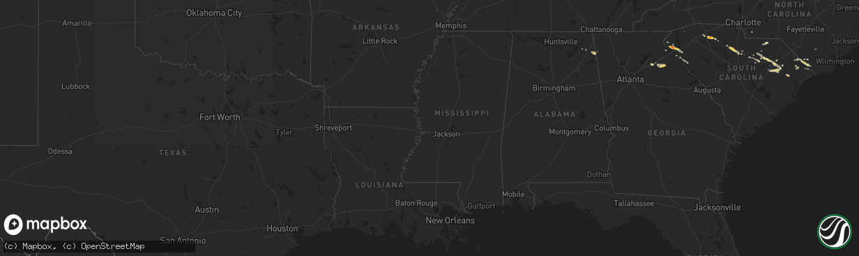
Hail Map on April 27, 2012
The weather event on April 27, 2012 includes Hail map. 10 states and 329 cities were impacted and suffered possible damage. The total estimated number of properties impacted is 0.
Want more than just the map?
Turn this storm into a full workflow.
- Owner + property data so you know who to knock
- OnDemand branded weather history reports to win the "did we even have hail?" argument
- RoofTrace estimate so reps stop guessing numbers at the door
Bought this map? Upgrade within 7 days and we'll credit the $230. (10-15 min setup call)
Hail
0
Estimated number of impacted properties by a 1.00" hail or larger10,970
Estimated number of impacted properties by a 1.75" hail or larger0
Estimated number of impacted properties by a 2.50" hail or largerStates Impacted by Hail Map on April 27, 2012
Storm reports
Missouri
| Date | Description |
|---|---|
| 04/27/201210:55 AM CDT | A local report indicates 1.00 inch wind near FAIR GROVE |
| 04/26/20129:42 PM CDT | A local report indicates 1.00 inch wind near 3 E EL DORADO SPRINGS |
South Carolina
| Date | Description |
|---|---|
| 04/27/20126:30 PM CDT | Public reported penny to quarter size hail at blackstock. |
| 04/27/20126:25 PM CDT | A local report indicates 1.00 inch wind near BLACKSTOCK |
| 04/27/20125:55 PM CDT | Large limbs down and quarter size hail |
| 04/27/20125:38 PM CDT | Chesterfield county sheriff reported trees down on powerlines in the city of chesterfield. |
| 04/27/20125:15 PM CDT | A local report indicates 1.00 inch wind near 1 N COWARD |
| 04/27/20124:49 PM CDT | Quarter size hail |
| 04/27/20124:35 PM CDT | Mainly pea size hail. Some nickle size with a few quarter size. Lasted 5 minutes. |
| 04/27/20124:32 PM CDT | Public reported dime to quarter size hail along timber creek road. It hailed for 10 to 15 minutes and covered the ground. |
| 04/27/20124:31 PM CDT | Trees down on trotter rd at highway 29 and nearby on travis road at mt olive baptist church. |
| 04/27/20124:27 PM CDT | Tree down along old hunts bridge road at faith dr. |
| 04/27/20124:16 PM CDT | Tree down on roadway on west seven pines rd. Reported by sc highway patrol. |
| 04/27/20124:15 PM CDT | Em reports a roof off a mobile home partially lifted and a large tree down on a liquor store |
| 04/27/20124:05 PM CDT | Dacusville fire department removed a tree from powerlines on connelly road. |
| 04/27/20123:51 PM CDT | Golf ball hail reported on highway 215 at foster mill circle. |
| 04/27/20123:30 PM CDT | Multiple trees down across westminster. |
| 04/27/20123:30 PM CDT | Quarter sized hail. |
| 04/27/20123:28 PM CDT | A local report indicates 1.00 inch wind near FAIR PLAY |
| 04/27/20123:25 PM CDT | Mini mart in bethune reported quarter size hail in the city. |
| 04/27/20123:25 PM CDT | A local report indicates 2.00 inch wind near 5 SSE WESTMINSTER |
North Carolina
| Date | Description |
|---|---|
| 04/27/20126:06 PM CDT | Nickel and quarter sized hail fell |
| 04/27/20125:48 PM CDT | Quarter sized hail mixed in with a lot of smaller stones |
Iowa
| Date | Description |
|---|---|
| 04/27/201212:07 AM CDT | Tree fell on car in cedar falls...estimated 50 mph winds with passing storms. |
Kansas
| Date | Description |
|---|---|
| 04/27/20126:59 PM CDT | Several outbuildings damaged...trees uprooted |
| 04/27/20126:55 PM CDT | A local report indicates 60 MPH wind near 3 SSW AUBURN |
| 04/27/20126:55 PM CDT | Near burlingame and 125th street. |
| 04/27/20126:48 PM CDT | Numerous tree limbs down at intersection of west 125th and hoch roads. Largest are just over 3 inches in diameter. Time estimated by radar. |
| 04/27/20126:45 PM CDT | A local report indicates 1.00 inch wind near 6 NE HARVEYVILLE |
| 04/27/20126:43 PM CDT | A local report indicates 1.00 inch wind near 3 NE HARVEYVILLE |
| 04/27/20126:37 PM CDT | A local report indicates 1.75 inch wind near SW HARVEYVILLE |
| 04/27/20126:27 PM CDT | A local report indicates 1.00 inch wind near 10 WNW OSAGE CITY |
| 04/27/20125:59 PM CDT | Delayed report. Multiple storm chasers reported a brief 30 second touchdown in northern morris county. No damage from this tornado has been reported. |
| 04/27/20125:42 PM CDT | A local report indicates 1.00 inch wind near 2 SW DWIGHT |
| 04/27/20125:35 PM CDT | 3 inch diameter tree limb blown down. |
| 04/27/20125:22 PM CDT | A local report indicates 1.00 inch wind near JUNCTION CITY |
| 04/27/20125:01 PM CDT | A local report indicates 1.00 inch wind near 3 W WOODBINE |
| 04/27/20124:38 PM CDT | Brief touchdown reported. |
| 04/27/20124:20 PM CDT | A local report indicates 1.75 inch wind near 5 N DELPHOS |
| 04/27/20124:18 PM CDT | Hail covering the ground. |
| 04/27/20124:12 PM CDT | A local report indicates 1.00 inch wind near 3 W DELPHOS |
| 04/27/20123:33 PM CDT | Quarter size hail at solomon rapids |
| 04/27/20123:08 PM CDT | A local report indicates 1.00 inch wind near GLEN ELDER |
| 04/27/20123:06 PM CDT | Hail falling at glen elder reservoir. |
| 04/27/20122:16 PM CDT | A local report indicates 1.25 inch wind near 2 SW TIPTON |
| 04/27/20127:40 AM CDT | A local report indicates 1.00 inch wind near 3 S VODA |
| 04/26/20129:48 PM CDT | Speed limit sign blown over...6-8 inch diameter tree limbs broken...weather vane blown off roof |
| 04/26/20128:55 PM CDT | A local report indicates 1.75 inch wind near 4 S DEERFIELD |
| 04/26/20128:45 PM CDT | A local report indicates 1.00 inch wind near 5 S LAKIN |
| 04/26/20128:22 PM CDT | A local report indicates 1.00 inch wind near 6 W LAKIN |
| 04/26/20128:20 PM CDT | Mainly quarter but a few half dollar size hail |
| 04/26/20128:08 PM CDT | A local report indicates 1.00 inch wind near 1 E SYRACUSE |
| 04/26/20128:02 PM CDT | A local report indicates 1.00 inch wind near 4 WNW SYRACUSE |
| 04/26/20127:26 PM CDT | Hail reported at 21st street and washburn |
| 04/26/20127:24 PM CDT | Hail reported at 21st street and oakley. |
Cities Impacted by Hail Map on April 27, 2012
- Lyerly, GA
- Mentone, AL
- Gaylesville, AL
- Waldo, KS
- Osborne, KS
- Paradise, KS
- Garden City, KS
- Townville, SC
- Westminster, SC
- Fair Play, SC
- Seneca, SC
- Topeka, KS
- Chester, SC
- Green Sea, SC
- El Dorado Springs, MO
- Stockton, MO
- Collins, MO
- Osceola, MO
- Glasco, KS
- Delphos, KS
- Chesterfield, SC
- Concordia, KS
- Maple Hill, KS
- Paxico, KS
- Clifton, KS
- Beloit, KS
- Hill City, KS
- Mullins, SC
- Loris, SC
- Nichols, SC
- Tabor City, NC
- Fair Bluff, NC
- Lenora, KS
- Jefferson, GA
- Florence, SC
- Clyde, KS
- Minneapolis, KS
- Morganville, KS
- Aurora, KS
- Humansville, MO
- Grove, OK
- Timmonsville, SC
- Lamar, SC
- Darlington, SC
- Bishopville, SC
- Hartsville, SC
- Luray, KS
- Alda, NE
- Wood River, NE
- Saint Edward, NE
- Genoa, NE
- Hartwell, GA
- Overbrook, KS
- Lawrence, KS
- Effingham, SC
- Rainsville, AL
- Fyffe, AL
- Kensington, KS
- Falcon, MO
- Lebanon, MO
- Smith Center, KS
- Gaylord, KS
- Cedar, KS
- Athol, KS
- Hays, KS
- Alta Vista, KS
- Strong City, KS
- Alma, KS
- White City, KS
- Wilsey, KS
- Dwight, KS
- Burdick, KS
- Council Grove, KS
- Springfield, MO
- Fair Grove, MO
- Scranton, SC
- Coward, SC
- Olanta, SC
- Pamplico, SC
- Lynchburg, SC
- Casey, IA
- Adair, IA
- Guthrie Center, IA
- Ava, MO
- Kearney, NE
- Spartanburg, SC
- Pauline, SC
- Roebuck, SC
- McClelland, IA
- Underwood, IA
- Willard, MO
- Conway, MO
- Monroe, NE
- Woodston, KS
- Wakefield, KS
- Milford, KS
- Clay Center, KS
- Leonardville, KS
- Junction City, KS
- Riley, KS
- Nevada, MO
- Buffalo, MO
- Elkland, MO
- Pickens, SC
- Rockville, MO
- Eads, CO
- Johnsonville, SC
- Penokee, KS
- Weston, NE
- Blackstock, SC
- Winnsboro, SC
- Ellis, KS
- Henderson, IA
- Reading, KS
- Admire, KS
- Longford, KS
- Silver Lake, KS
- Osage City, KS
- Jerico Springs, MO
- Glen Elder, KS
- Wilcox, NE
- Jonesville, SC
- Kennard, NE
- Clinton, MO
- Auburn, KS
- Long Lane, MO
- Logan, IA
- Persia, IA
- Burlingame, KS
- Harveyville, KS
- Juniata, NE
- Roseland, NE
- Kenesaw, NE
- Lucas, KS
- Tipton, KS
- Fort Riley, KS
- Chapman, KS
- Hope, KS
- Woodbine, KS
- Enterprise, KS
- Solomon, KS
- Salina, KS
- New Cambria, KS
- Abilene, KS
- Fulton, KS
- Mapleton, KS
- Fort Scott, KS
- Clarendon, NC
- Grantville, KS
- Emporia, KS
- Allen, KS
- Camden, SC
- Cassatt, SC
- Albion, NE
- Louisburg, MO
- Pomona, MO
- West Plains, MO
- Nicholson, GA
- Hull, GA
- Fullerton, NE
- Minden, NE
- Bogue, KS
- Half Way, MO
- Mankato, KS
- Brainard, NE
- Jamestown, KS
- Wakeeney, KS
- Colbert, GA
- Commerce, GA
- Hoschton, GA
- Bethune, SC
- Simpson, KS
- Gibbon, NE
- Randall, KS
- Jewell, KS
- Stockton, KS
- Clarks, NE
- Red Cloud, NE
- Inavale, NE
- Bladen, NE
- Riverdale, NE
- Hunter, KS
- Leon, KS
- Centerville, KS
- Bolivar, MO
- Brighton, MO
- Norway, KS
- Esbon, KS
- Ridgeway, SC
- Holdrege, NE
- Republican City, NE
- Naponee, NE
- Downs, KS
- Wahoo, NE
- Ceresco, NE
- Union, SC
- Pleasanton, KS
- Silver City, IA
- Ithaca, NE
- Monroe, NC
- Clarkton, NC
- Carroll, IA
- Birch Tree, MO
- Morrisville, MO
- Eastanollee, GA
- Strafford, MO
- Wayne, NE
- Exira, IA
- Audubon, IA
- Kimballton, IA
- McFarland, KS
- Rossville, KS
- Eskridge, KS
- Saint Marys, KS
- Bunker Hill, KS
- Cawker City, KS
- Rogers, NE
- Bloomington, NE
- Hildreth, NE
- Linn, KS
- Palmer, KS
- Barnard, KS
- Shelton, NE
- Little Sioux, IA
- Mondamin, IA
- Blencoe, IA
- Pisgah, IA
- Onawa, IA
- Rembert, SC
- Mayetta, KS
- Hoyt, KS
- Amherst, NE
- Holstein, NE
- Cairo, NE
- Bruno, NE
- Chadbourn, NC
- Whiteville, NC
- Delia, KS
- Ingalls, KS
- Lowndesville, SC
- Calhoun Falls, SC
- Iva, SC
- Hancock, IA
- Bennington, NE
- Newman Grove, NE
- Gresham, NE
- Shelby, NE
- Fort Payne, AL
- Ravenna, NE
- Braselton, GA
- Marshfield, MO
- Butler, MO
- Upland, NE
- Russell, KS
- Mountain View, MO
- Franklin, NE
- Danielsville, GA
- Athens, GA
- Valparaiso, NE
- Bee, NE
- Grand Island, NE
- Kirwin, KS
- Schell City, MO
- Harwood, MO
- Toccoa, GA
- Anderson, SC
- Warsaw, MO
- Windsor, MO
- Gypsum, KS
- Galivants Ferry, SC
- Phillipsburg, KS
- Glade, KS
- Stromsburg, NE
- Pendergrass, GA
- Vanzant, MO
- Drury, MO
- Riverton, NE
- Niangua, MO
- Carroll, NE
- Winside, NE
- Malvern, IA
- Glenwood, IA
- Elba, NE
- Campbell, NE
- Axtell, NE
- Wakarusa, KS
- Carbondale, KS
- Portis, KS
- Agra, KS
- Walker, MO
- Lakin, KS
- Danbury, IA
- David City, NE
- Staplehurst, NE
- Ulysses, NE
- Seward, NE
- Norwood, MO
- Ayr, NE
- El Dorado, KS
- Doniphan, NE
- Hastings, NE
- Aynor, SC
- Osceola, NE
- Silver Creek, NE
- Carson, IA
- McBee, SC
- Heartwell, NE
- Haddam, KS
- Agenda, KS
- Alma, NE
- Omaha, NE
- Duncan, SC
- Moore, SC
- Mountain Grove, MO
- Cedar Rapids, NE
- Scranton, KS
- Appleton City, MO
- Cerro Gordo, NC
- Arcadia, NE
- Shelby, IA
- Portsmouth, IA
- Ash Grove, MO
- Craig, MO
- Palco, KS
- Damar, KS
- Courtland, KS
- Magnolia, IA
- Lebanon, KS
- Hoskins, NE