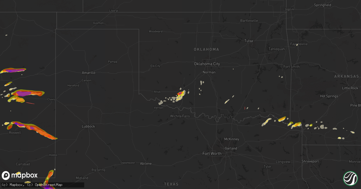
Hail Map on April 26, 2025
Get this storm
April 26 map
$229
one time, instant access
Download today. No call, no setup
Keep the $229
Bought the map and want the full workflow? Apply the entire $229 to a subscription within 7 days. None of it is wasted.
Every map, not just this one
This buys you this map. Subscription and you get every map we run, in the markets you choose from a few cities to whole states to nationwide. Plus real-time alerts the moment a storm fires.
Contact data
Name, contact info, occupancy, even credit band for addresses in the footprint. You go from where it hit to who to call.
Become the source they trust
Unlimited branding weather history reports on demand. You already have the documented answer ready for the property owner, and you are the one who showed up with it.
Property data and RoofTrace estimates
Pull up any address you have got, its value and the exact code rules for that jurisdiction, straight from One Click Code. Then RoofTrace estimates the squares, pitch, and roof value, priced the way you price.
States Impacted by Hail Map on April 26, 2025
Storm reports
Oklahoma
| Date | Description |
|---|---|
| 04/26/20256:12 PM CDT | Powerlines down. |
| 04/26/20255:38 PM CDT | A local report indicates 60 MPH wind near Haworth |
| 04/26/20255:35 PM CDT | A local report indicates 1.00 inch wind near Haworth |
| 04/26/20255:35 PM CDT | Tree downed onto power lines on east arkansas avenue in haworth. |
| 04/26/20252:30 PM CDT | Chaser reported tornado that lasted several minutes. Location estimated. |
| 04/26/20257:30 AM CDT | A local report indicates 1.75 inch wind near 3 WNW Lawton |
| 04/26/20257:25 AM CDT | A local report indicates 1.00 inch wind near 3 W Lawton |
| 04/26/20257:11 AM CDT | A local report indicates 1.75 inch wind near 3 SW Lawton |
South Carolina
| Date | Description |
|---|---|
| 04/26/20256:41 PM CDT | Received a report of quarter size hail... Some stones approaching ping pong ball size. Time estimated using radar data. |
| 04/26/20255:10 PM CDT | Hail up to 2 inches deep... Some up to quarter sized. |
Colorado
| Date | Description |
|---|---|
| 04/25/20257:48 PM CDT | Report from mping: ping pong ball |
| 04/25/20257:33 PM CDT | Report via x. Time estimated based on radar. |
New Mexico
| Date | Description |
|---|---|
| 04/26/20256:48 PM CDT | A local report indicates a tornado near 12 NNW Bitter Lake Wild |
| 04/26/20256:42 PM CDT | Tornado photographed 3 miles north of location. |
| 04/26/20256:15 PM CDT | A local report indicates 2.00 inch wind near 9 SE Variadero |
| 04/26/20255:58 PM CDT | A local report indicates 1.50 inch wind near 7 ENE Yeso |
| 04/26/20255:51 PM CDT | A local report indicates 1.00 inch wind near 2 S Yeso |
| 04/25/20258:55 PM CDT | Storm chasers reported ping pong sized hail 3 miles east of tatum... Nm. |
| 04/25/20258:55 PM CDT | The tatum mesonet recorded a wind speed of 59 mph. |
| 04/25/20258:50 PM CDT | A storm chaser reported 2 inch hail approximately 2.4 miles to the east of tatum... Nm and blew out windshield of vehicle. |
| 04/25/20258:46 PM CDT | A storm chaser reported half dollar sized hail in downtown tatum... Nm at 02:46z. |
| 04/25/20257:32 PM CDT | Trained spotter reported half dollar sized hail 6 miles north of jal... Nm at 00:32z. |
| 04/25/20257:21 PM CDT | A trained spotter reported quarter sized hail in jal... Nm at 00:21z. |
| 04/25/20257:06 PM CDT | Social media video shows tornado on the ground near acme nm. |
| 04/25/20257:05 PM CDT | A local report indicates 2.50 inch wind near 8 NNE Bitter Lake Wildl |
Arkansas
| Date | Description |
|---|---|
| 04/26/20256:59 PM CDT | A local report indicates 65 MPH wind near Jenny Lind |
| 04/26/20256:50 PM CDT | Quarter-sized hail reported near the sheriffs office. |
| 04/26/20256:39 PM CDT | Tree partially blocking the road. |
| 04/26/202512:40 AM CDT | A local report indicates 1.00 inch wind near 1 WSW El Dorado |
Texas
| Date | Description |
|---|---|
| 04/26/20256:50 PM CDT | An emergency manager in pecos county reported golf ball and tennis ball sized hail. |
| 04/26/20256:47 PM CDT | Corrects previous hail report from 1 n pecos. Multiple reports of golf ball to hen egg size hail in pecos. Time verified by reports and radar. |
| 04/26/20256:47 PM CDT | Corrects previous hail report from 1 n pecos. Multiple reports of golf ball to hen egg size hail in pecos. Time verified by rep |
| 04/26/20256:38 PM CDT | Corrects previous hail report from 1 ssw pecos. Golf ball size hail reported per broadcast media source. Time estimated by radar and report. |
| 04/26/20256:36 PM CDT | Quarter size hail reported on state hwy 302 per spotter network. |
| 04/26/20255:47 PM CDT | Multiple reports of golf ball to hen egg size hail in pecos. Time verified by reports and radar. |
| 04/26/20255:38 PM CDT | Golf ball size hail reported per broadcast media source. Time estimated by radar and report. |
| 04/25/20258:15 PM CDT | Storm chaser jeff piotrowski reported 5 inch hail se of fort stockton... Tx. |
| 04/25/20258:06 PM CDT | Baseball sized hail reported on the west side of the city of fort stockton... Tx at approximately 01:06z. |
| 04/25/20258:05 PM CDT | Kwes reported tennis ball sized hail in the city of fort stockton... Tx. |
| 04/25/20257:55 PM CDT | Report from mping: hen egg |
| 04/25/20257:48 PM CDT | Pecos county em reported golf ball sized hail 1 mile south of fort stockton on us 385. |
| 04/25/20257:41 PM CDT | Pecos county em reported golf ball sized hail in the city of fort stockton... Tx. |
| 04/25/20257:22 PM CDT | Emergency manager reported tennis ball size hail on i-10 at mm 254 west of fort stockton. |
Connecticut
| Date | Description |
|---|---|
| 04/26/20255:51 PM CDT | Eversource reports 75 customers without power. |
| 04/26/20255:51 PM CDT | Eversource reports 75 customers without power. |
North Carolina
| Date | Description |
|---|---|
| 04/25/20258:25 PM CDT | Trees down blocking both lanes of highway 903... Near beasleys road. |
Cities Impacted by Hail Map on April 26, 2025
- Cache, OK
- Faxon, OK
- Lawton, OK
- Vernon, TX
- Fort Sill, OK
- Frederick, OK
- Davidson, OK
- Marlow, OK
- Duncan, OK
- Elgin, OK
- Loveland, OK
- Hollister, OK
- Rush Springs, OK
- Chattanooga, OK
- Walters, OK
- Geronimo, OK
- Bradley, OK
- Lindsay, OK
- Alex, OK
- Paris, TX
- Bokchito, OK
- Caddo, OK
- Blossom, TX
- Santa Rosa, NM
- Murrells Inlet, SC
- Detroit, TX
- Bennington, OK
- La Loma, NM
- Las Vegas, NM
- Mill Creek, OK
- Tishomingo, OK
- Ridgeland, SC
- Bagwell, TX
- Stonewall, OK
- Soper, OK
- Garita, NM
- Clarksville, TX
- Hugo, OK
- Yeso, NM
- Travelers Rest, SC
- Taylors, SC
- Idabel, OK
- Balmorhea, TX
- Capitan, NM
- Roswell, NM
- Greenville, SC
- Lane, SC
- Andrews, SC
- Simpsonville, SC
- Pecos, TX
- Haworth, OK
- Fort Sumner, NM
- De Kalb, TX
- Foreman, AR
- Samson, AL
- Defuniak Springs, FL
- Saint Stephen, SC
- Bokoshe, OK
- Shady Point, OK
- Barstow, TX
- New Boston, TX
- Conchas Dam, NM
- Pyote, TX
- Bonneau, SC
- Fort Stockton, TX
- Mentone, TX
- Hooks, TX
- Ashdown, AR
- Wink, TX
- Huger, SC
- Cordesville, SC
- Imperial, TX
- Coyanosa, TX
- Kermit, TX
- Jal, NM
- Newkirk, NM
- Hugo, CO
- Karval, CO
- Hope, AR
- Fulton, AR
- Cimarron, NM
- Texarkana, AR
- Monahans, TX
- Ogden, AR
- Turkey, NC
- Taiban, NM
- Warsaw, NC
- House, NM
- Tatum, NM
- Emmet, AR
- Rosston, AR
- Floyd, NM
- Melrose, NM
- Grandfalls, TX
- Buckner, AR
- Prescott, AR
- Waldo, AR
- Willisville, AR
- Crane, TX
- Dryden, TX
- Camden, AR
- Plains, TX
- Carlsbad, NM
- Clovis, NM
- Hermitage, AR
- Jersey, AR
- El Dorado, AR
- Farmington, AR
- Fayetteville, AR
- Hampton, AR
- Salters, SC