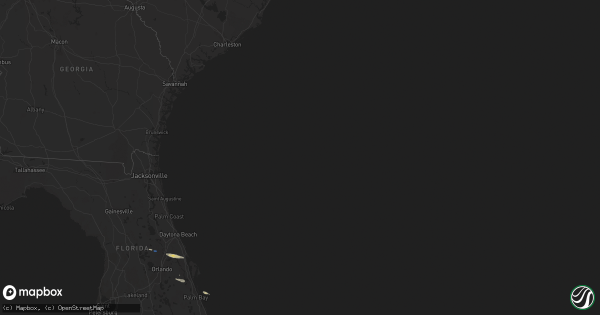
Hail Map on April 25, 2021
Get this storm
April 25 map
$229
one time, instant access
Download today. No call, no setup
Keep the $229
Bought the map and want the full workflow? Apply the entire $229 to a subscription within 7 days. None of it is wasted.
Every map, not just this one
This buys you this map. Subscription and you get every map we run, in the markets you choose from a few cities to whole states to nationwide. Plus real-time alerts the moment a storm fires.
Contact data
Name, contact info, occupancy, even credit band for addresses in the footprint. You go from where it hit to who to call.
Become the source they trust
Unlimited branding weather history reports on demand. You already have the documented answer ready for the property owner, and you are the one who showed up with it.
Property data and RoofTrace estimates
Pull up any address you have got, its value and the exact code rules for that jurisdiction, straight from One Click Code. Then RoofTrace estimates the squares, pitch, and roof value, priced the way you price.
Storm reports
California
| Date | Description |
|---|---|
| 04/25/202112:14 AM CDT | At 511 PM PDT, a severe thunderstorm was located near Los Molinos, or 10 miles northeast of Corning, moving northeast at 20 mph. HAZARD...Quarter size hail. Signicant hail accumulations of several inches possible along highway 99 near Los Molinos. SOURCE...Radar indicated. IMPACT...Damage to agriculture and hazardous driving. Locations impacted include... Corning, Tehama, Richfield, Gerber-Las Flores, Vina and Los Molinos. |
| 04/24/20217:46 PM CDT | A tornado briefly touched down on post ave. Between 4th and 5th ave. In capay on april 25. Minor damage was caused to 2 homes... Including roof tiles... A carport roof. |
| 04/24/20217:44 PM CDT | A brief tornado touchdown was observed in a farm field in capay on april 25. No damage has been reported. A video with swirling dust confirmed this was a tornado. The t |
Florida
| Date | Description |
|---|---|
| 04/25/20217:36 AM CDT | At 1236 AM EDT, a severe thunderstorm was located 10 miles northeast of Jasper, moving east at 45 mph. HAZARD...60 mph wind gusts and quarter size hail. Possible tornado. SOURCE...Radar indicated. IMPACT...Hail damage to vehicles is expected. Expect wind damage to roofs, siding, and trees. Locations impacted include... Fargo and Needmore. |
| 04/25/20214:44 AM CDT | At 943 AM EDT, a severe thunderstorm was located near Osteen, or near Geneva, moving east at 25 mph. HAZARD...60 mph wind gusts and quarter size hail. SOURCE...Radar indicated. IMPACT...Hail damage to vehicles is expected. Expect wind damage to roofs, siding, and trees. Locations impacted include... Deltona, Sanford, Oak Hill, Mims and Geneva. |
| 04/25/20213:39 AM CDT | At 838 AM EDT, a severe thunderstorm was located near Paisley, moving east at 30 mph. HAZARD...60 mph wind gusts and penny size hail. SOURCE...Radar indicated. IMPACT...Expect damage to roofs, siding, and trees. Locations impacted include... Deltona, Sanford, Lake Mary, Orange City and Cassia. |
| 04/24/20219:06 PM CDT | At 206 AM EDT, a severe thunderstorm was located near Wellborn, or 8 miles west of Lake City, moving east at 50 mph. HAZARD...60 mph wind gusts and quarter size hail. SOURCE...Radar indicated. IMPACT...Hail damage to vehicles is expected. Expect wind damage to roofs, siding, and trees. Locations impacted include... Lake City, Wellborn, Five Points, Watertown, Winfield, Olustee, Suwannee Valley and Sanderson. |
Georgia
| Date | Description |
|---|---|
| 04/25/20217:33 AM CDT | At 1233 AM EDT, a severe thunderstorm was located over Brunswick, moving east at 45 mph. HAZARD...60 mph wind gusts and quarter size hail. SOURCE...Radar indicated. IMPACT...Hail damage to vehicles is expected. Expect wind damage to roofs, siding, and trees. Locations impacted include... Brunswick, St. Simons Island, Dock Junction, Country Club Estates, Sea Island, Jekyll Island and Dover Bluff. |
| 04/25/20217:07 AM CDT | At 1206 AM EDT, a severe thunderstorm was located near Screven, or near Jesup, moving east at 60 mph. HAZARD...60 mph wind gusts and quarter size hail. SOURCE...Radar indicated. IMPACT...Hail damage to vehicles is expected. Expect wind damage to roofs, siding, and trees. Locations impacted include... Jesup, Gardi, Screven and Doctortown. |
| 04/25/20217:01 AM CDT | At 1201 AM EDT, a severe thunderstorm was located 7 miles east of Hickox, or 7 miles southeast of Nahunta, moving east at 40 mph. HAZARD...60 mph wind gusts and quarter size hail. Possible tornado. SOURCE...Radar indicated. IMPACT...Hail damage to vehicles is expected. Expect wind damage to roofs, siding, and trees. Locations impacted include... Brunswick, Woodbine, Dock Junction, Country Club Estates, Waverly, Waynesville, Jekyll Island, Tarboro and Dover Bluff. |
| 04/24/20219:12 PM CDT | At 212 AM EDT, a severe thunderstorm was located near St. George, or 16 miles southwest of Callahan, moving east at 50 mph. HAZARD...60 mph wind gusts and quarter size hail. SOURCE...Radar indicated. IMPACT...Hail damage to vehicles is expected. Expect wind damage to roofs, siding, and trees. Locations impacted include... Fernandina Beach, Callahan, Jacksonville International Arpt, Yulee, Cisco Gardens, Nassau Village-Ratliff, Ratliff, St. George, Oceanway and Little Talbot Island. |
| 04/24/20218:15 PM CDT | At 115 AM EDT, a severe thunderstorm was located near Jasper, moving east at 50 mph. HAZARD...60 mph wind gusts and quarter size hail. SOURCE...Radar indicated. IMPACT...Hail damage to vehicles is expected. Expect wind damage to roofs, siding, and trees. Locations impacted include... Jasper, Taylor and Belmont. |