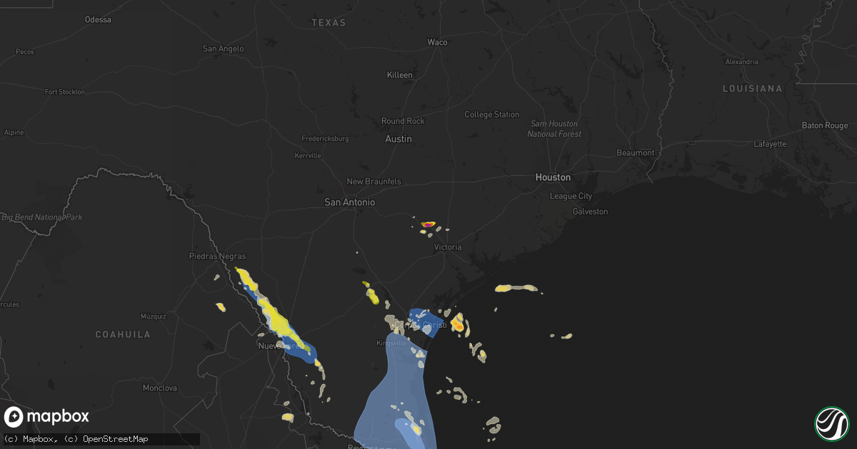
Hail Map on April 23, 2023
Get this storm
April 23 map
$229
one time, instant access
Download today. No call, no setup
Keep the $229
Bought the map and want the full workflow? Apply the entire $229 to a subscription within 7 days. None of it is wasted.
Every map, not just this one
This buys you this map. Subscription and you get every map we run, in the markets you choose from a few cities to whole states to nationwide. Plus real-time alerts the moment a storm fires.
Contact data
Name, contact info, occupancy, even credit band for addresses in the footprint. You go from where it hit to who to call.
Become the source they trust
Unlimited branding weather history reports on demand. You already have the documented answer ready for the property owner, and you are the one who showed up with it.
Property data and RoofTrace estimates
Pull up any address you have got, its value and the exact code rules for that jurisdiction, straight from One Click Code. Then RoofTrace estimates the squares, pitch, and roof value, priced the way you price.
Storm reports
Texas
| Date | Description |
|---|---|
| 04/23/20232:12 PM CDT | Large metal structure destroyed and blown onto highway 100 about a mile or two west of downtown los fresnos. |
| 04/23/20232:00 PM CDT | Power lines down near idea robindale school. |
| 04/23/20231:53 PM CDT | Multiple large tree branches down in residential area. |
| 04/23/20231:53 PM CDT | Wood paneled fence and gate blown down at the sa recyling facility. |
| 04/23/20231:47 PM CDT | A local report indicates 59 MPH wind near 4 ESE BROWNSVILLE |
| 04/23/20231:45 PM CDT | Siding damage to house in north los fresnos. Location and timing are approximated. |
| 04/23/20231:38 PM CDT | A local report indicates 68 MPH wind near 4 NE BAYVIEW |
| 04/23/20231:03 PM CDT | A local report indicates 61 MPH wind near 3 NE HARLINGEN |
| 04/23/20231:02 PM CDT | A local report indicates 68 MPH wind near 2 S MCALLEN |
| 04/23/202312:30 PM CDT | Roof peeled back. |
| 04/23/202311:04 AM CDT | Corpus christi nas asos reported peak wind of 51 kts. |
| 04/23/202310:48 AM CDT | Awos station knqi kingsville nas. |
| 04/23/202310:42 AM CDT | A local report indicates 60 MPH wind near 3 NW CC NAS |
| 04/23/202310:15 AM CDT | Awos station klrd laredo. |
| 04/23/202310:01 AM CDT | Asos station kali alice. |
| 04/23/202310:00 AM CDT | Photo of tree uprooted at texas a&m international university campus. Reported by trained spotter. Time estimated by radar. |
| 04/23/20239:55 AM CDT | Wooden fence blown down. |
| 04/23/20239:52 AM CDT | Quarter-size hail picture reported in central laredo. |
| 04/23/20239:39 AM CDT | Report from mping: 1-inch tree limbs broken; shingles blown off. |
| 04/23/20237:20 AM CDT | Reports of golf ball size hail at the intersection of tulley rd and bubba palmer rd in cuero. Report relayed via broadcast media. |
| 04/23/20237:15 AM CDT | Public report of ping pong ball size hail near the intersection of e clayton st and n clinton st in cuero. Time estimated from radar. Report relayed via social media. |
| 04/23/20237:12 AM CDT | Golf ball size hail in cuero. Time estimated from radar. |
Cities Impacted by Hail Map on April 23, 2023
- Eagle Pass, TX
- Carrizo Springs, TX
- Asherton, TX
- Laredo, TX
- Mirando City, TX
- Hebbronville, TX
- Sinton, TX
- Port Aransas, TX
- Portland, TX
- Corpus Christi, TX
- Ingleside, TX
- Odem, TX
- Aransas Pass, TX
- Gregory, TX
- Taft, TX
- George West, TX
- Three Rivers, TX
- Orange Grove, TX
- Sandia, TX
- Cuero, TX
- Yoakum, TX
- Kingsville, TX
- Bishop, TX
- Riviera, TX
- Armstrong, TX
- Sarita, TX
- Linn, TX
- San Perlita, TX
- Port Mansfield, TX
- Raymondville, TX
- Lyford, TX
- Harlingen, TX
- Edcouch, TX
- Rockport, TX
- Mathis, TX
- Robstown, TX
- Zapata, TX
- Inez, TX
- Victoria, TX
- Yorktown, TX
- Guerra, TX
- Alice, TX
- Rio Hondo, TX
- Los Fresnos, TX
- Sebastian, TX
- Combes, TX
- Santa Rosa, TX
- San Benito, TX
- South Padre Island, TX
- Encino, TX
- Donna, TX
- Mcallen, TX
- Mission, TX
- Mercedes, TX
- Edinburg, TX
- Weslaco, TX
- Hargill, TX
- Elsa, TX
- La Villa, TX
- Alamo, TX
- Pharr, TX
- La Feria, TX
- San Juan, TX
- La Joya, TX
- Hidalgo, TX
- Progreso, TX
- Olmito, TX
- Brownsville, TX
- Port Isabel, TX
- Roma, TX
- Rio Grande City, TX
- Punta Gorda, FL