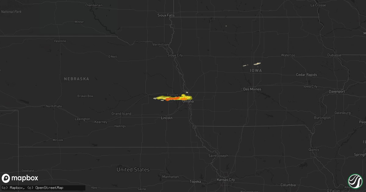
Hail Map on April 21, 2025
Get this storm
April 21 map
$229
one time, instant access
Download today. No call, no setup
Keep the $229
Bought the map and want the full workflow? Apply the entire $229 to a subscription within 7 days. None of it is wasted.
Every map, not just this one
This buys you this map. Subscription and you get every map we run, in the markets you choose from a few cities to whole states to nationwide. Plus real-time alerts the moment a storm fires.
Contact data
Name, contact info, occupancy, even credit band for addresses in the footprint. You go from where it hit to who to call.
Become the source they trust
Unlimited branding weather history reports on demand. You already have the documented answer ready for the property owner, and you are the one who showed up with it.
Property data and RoofTrace estimates
Pull up any address you have got, its value and the exact code rules for that jurisdiction, straight from One Click Code. Then RoofTrace estimates the squares, pitch, and roof value, priced the way you price.
States Impacted by Hail Map on April 21, 2025
Storm reports
Pennsylvania
| Date | Description |
|---|---|
| 04/21/20254:29 PM CDT | Tree down at highway 86 and hodges ln... Time estimated via radar. |
| 04/21/20254:28 PM CDT | Tree down on mcclellan st. Exd. |
| 04/21/20254:26 PM CDT | Tree down at highway 98 and coleman rd. |
Nebraska
| Date | Description |
|---|---|
| 04/21/20255:53 PM CDT | A local report indicates 58 MPH wind near 4 SE Lynch |
| 04/21/20254:31 PM CDT | A local report indicates 62 MPH wind near 6 S Springview |
| 04/21/20254:00 PM CDT | A local report indicates 62 MPH wind near 8 NE Johnstown |
| 04/21/20252:15 PM CDT | A local report indicates 59 MPH wind near 2 WNW Bingham |
| 04/20/202511:04 PM CDT | Report from mping: ping pong ball |
| 04/20/202511:04 PM CDT | A local report indicates 1.25 inch wind near 3 NNE Omaha |
| 04/20/202511:03 PM CDT | A local report indicates 1.50 inch wind near 6 NNE Omaha |
| 04/20/202511:03 PM CDT | Report from mping: half dollar |
| 04/20/202510:58 PM CDT | Report from mping: ping pong ball |
| 04/20/202510:55 PM CDT | A local report indicates 1.75 inch wind near 3 NW Omaha |
| 04/20/202510:54 PM CDT | A local report indicates 1.00 inch wind near 4 NW Omaha |
| 04/20/202510:54 PM CDT | A local report indicates 1.00 inch wind near 5 N Omaha |
| 04/20/202510:53 PM CDT | A local report indicates 1.00 inch wind near 6 SSE Fort Calhoun |
| 04/20/202510:52 PM CDT | 680 and blair high rd. |
| 04/20/202510:52 PM CDT | A local report indicates 1.00 inch wind near 4 NNE Boys Town |
| 04/20/202510:52 PM CDT | A local report indicates 1.00 inch wind near 4 NE Boys Town |
| 04/20/202510:47 PM CDT | A local report indicates 1.75 inch wind near 4 NNW Boys Town |
| 04/20/202510:44 PM CDT | Report from mping: ping pong ball |
| 04/20/202510:42 PM CDT | Half dollar. |
| 04/20/202510:42 PM CDT | Report from mping: quarter |
| 04/20/202510:42 PM CDT | Report from mping: quarter |
| 04/20/202510:40 PM CDT | Report from mping: quarter |
| 04/20/202510:38 PM CDT | Report from mping: half dollar |
| 04/20/202510:26 PM CDT | Somewhat flat... Disk-shaped hail up to 1.5 inches in diameter. The largest hail was similar to cauliflower... A congealed hailstone made up of many very small hailston |
| 04/20/202510:19 PM CDT | A local report indicates 1.50 inch wind near Leshara |
| 04/20/202510:06 PM CDT | Snowball-like hail. |
New York
| Date | Description |
|---|---|
| 04/21/20255:18 PM CDT | Delayed report. Multiple trees down near the town line between gerry and ellicott. |
| 04/21/20255:15 PM CDT | Tree on a house. Multiple wires down. Time estimated based on radar. |
| 04/21/20255:15 PM CDT | Delayed report. Multiple trees down on route 60 near the jamestown airport. |
| 04/21/20255:07 PM CDT | Delayed report. Multiple trees down in the town of stow. |
Missouri
| Date | Description |
|---|---|
| 04/21/20255:18 PM CDT | An nws survey team found high-end ef1 tornado damage along a path extending from highway 763 and northeast through columbia... Mo. This tornado was on the ground from 5 |
Montana
| Date | Description |
|---|---|
| 04/21/20254:55 PM CDT | [landspout] time approximated. Spotter reported that it dissipated shortly after he first saw it. Location approximated based upon spotter seeing it at the border of c |
Cities Impacted by Hail Map on April 21, 2025
- Baytown, TX
- Dickinson, TX
- League City, TX
- Bacliff, TX
- Texas City, TX
- Port Mansfield, TX
- Bay City, TX
- Lorman, MS
- Parrish, AL
- Forest, MS
- Cordova, AL
- Walnut Grove, MS
- Conehatta, MS
- Morton, MS
- Union, MS
- Dora, AL
- Decatur, MS
- Philadelphia, MS
- Sebastopol, MS
- Quinton, AL
- Sumiton, AL
- Hazlehurst, MS
- Crystal Springs, MS
- Bellwood, NE
- David City, NE
- Linwood, NE
- Bruno, NE
- Abie, NE
- Prague, NE
- Morse Bluff, NE
- Malmo, NE
- Cedar Bluffs, NE
- Colon, NE
- Fremont, NE
- Mead, NE
- Valley, NE
- Yutan, NE
- Bennington, NE
- Elkhorn, NE
- Waterloo, NE
- Omaha, NE
- Kennard, NE
- Blair, NE
- Fort Calhoun, NE
- Crescent, IA
- Honey Creek, IA
- Carter Lake, IA
- Council Bluffs, IA
- Underwood, IA
- Missouri Valley, IA
- Stratford, IA
- Radcliffe, IA
- Ellsworth, IA
- Story City, IA
- Hubbard, IA