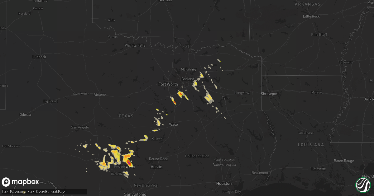
Hail Map on April 21, 2014
Get this storm
April 21 map
$229
one time, instant access
Download today. No call, no setup
Keep the $229
Bought the map and want the full workflow? Apply the entire $229 to a subscription within 7 days. None of it is wasted.
Every map, not just this one
This buys you this map. Subscription and you get every map we run, in the markets you choose from a few cities to whole states to nationwide. Plus real-time alerts the moment a storm fires.
Contact data
Name, contact info, occupancy, even credit band for addresses in the footprint. You go from where it hit to who to call.
Become the source they trust
Unlimited branding weather history reports on demand. You already have the documented answer ready for the property owner, and you are the one who showed up with it.
Property data and RoofTrace estimates
Pull up any address you have got, its value and the exact code rules for that jurisdiction, straight from One Click Code. Then RoofTrace estimates the squares, pitch, and roof value, priced the way you price.
Storm reports
Texas
| Date | Description |
|---|---|
| 04/21/20146:56 PM CDT | Quarter size hail in waxahachie |
| 04/21/20146:46 PM CDT | A local report indicates 2.00 inch wind near 2 WSW WILLOW CITY |
| 04/21/20146:43 PM CDT | Pea to quarter sized hail covering the ground in willow city |
| 04/21/20146:43 PM CDT | Golfball size hail 2 miles northwest of waxahachie |
| 04/21/20146:38 PM CDT | A local report indicates 1.75 inch wind near 5 W WILLOW CITY |
| 04/21/20146:13 PM CDT | A local report indicates 1.00 inch wind near 12 SE MASON |
| 04/21/20146:09 PM CDT | A local report indicates 1.75 inch wind near 13 S LLANO |
| 04/21/20146:07 PM CDT | Quarter size hail in lampasas |
| 04/21/20146:02 PM CDT | A local report indicates 2.00 inch wind near 6 NNW ENCHANTED ROCK ST |
| 04/21/20145:50 PM CDT | Hail sizes ranged from half inch to 1.50 inches |
| 04/21/20145:43 PM CDT | Quarter size hail in ennis |
| 04/21/20145:39 PM CDT | Reported at the airport in mason. |
| 04/21/20145:29 PM CDT | Quarter size hail 5 miles north of meridian |
| 04/21/20145:28 PM CDT | A local report indicates 1.50 inch wind near MASON |
| 04/21/20145:28 PM CDT | A local report indicates 1.00 inch wind near 1 SSE MASON |
| 04/21/20145:18 PM CDT | A local report indicates 1.50 inch wind near 4 E CHAPPEL |
| 04/21/20145:13 PM CDT | Time estimated from radar |
| 04/21/20145:00 PM CDT | A local report indicates 1.25 inch wind near 10 NE MASON |
| 04/21/20144:25 PM CDT | A local report indicates 1.25 inch wind near 2 S LLANO |
| 04/21/20144:07 PM CDT | A local report indicates 1.00 inch wind near 1 N LLANO |
| 04/21/20144:00 PM CDT | A local report indicates 1.00 inch wind near 1 ESE LLANO |
| 04/20/201410:31 PM CDT | Hail stripped the leaves off of the trees. Report relayed by wfo ewx. Time radar estimated. |
| 04/20/20149:40 PM CDT | A local report indicates 1.00 inch wind near 6 WSW HARPER |
| 04/20/20148:38 PM CDT | A local report indicates 1.00 inch wind near 2 SE BANKERSMITH |
| 04/20/20148:22 PM CDT | Some quarter size hail mixed with mostly smaller pieces. |
| 04/20/20148:16 PM CDT | Time radar estimated. |
| 04/20/20148:05 PM CDT | A local report indicates 1.25 inch wind near 2 SE KATEMCY |
| 04/20/20147:45 PM CDT | A local report indicates 1.00 inch wind near KATEMCY |
| 04/20/20147:25 PM CDT | Ping pong ball size hail in itasca |
| 04/20/20147:10 PM CDT | Location is 3.5 miles north of stonewall |
| 04/20/20147:03 PM CDT | A local report indicates 1.00 inch wind near 12 N FREDERICKSBURG |
Cities Impacted by Hail Map on April 21, 2014
- Wills Point, TX
- Ennis, TX
- Palmer, TX
- Waxahachie, TX
- Menard, TX
- Llano, TX
- Doss, TX
- Mason, TX
- Fredericksburg, TX
- Mountain Home, TX
- Harper, TX
- Junction, TX
- Lampasas, TX
- Kempner, TX
- Crawford, TX
- Eldorado, TX
- Midlothian, TX
- Red Oak, TX
- Clifton, TX
- Valley Mills, TX
- Gatesville, TX
- Johnson City, TX
- Stonewall, TX
- Willow City, TX
- Castell, TX
- Terrell, TX
- Quinlan, TX
- Mabank, TX
- Eustace, TX
- Canton, TX
- Athens, TX
- Murchison, TX
- Itasca, TX
- Grandview, TX
- Cranfills Gap, TX
- Kaufman, TX
- London, TX
- Palestine, TX
- Frankston, TX
- Meridian, TX
- Rusk, TX
- Comfort, TX
- Cedar Hill, TX
- Malakoff, TX
- Lone Oak, TX
- Emory, TX
- Walnut Springs, TX
- Crandall, TX
- Royse City, TX
- Rockwall, TX
- Forney, TX
- San Saba, TX
- Cherokee, TX
- Lancaster, TX
- Milford, TX
- Pecan Gap, TX
- Klondike, TX
- Larue, TX
- Art, TX
- Pontotoc, TX
- Boerne, TX
- Grand Saline, TX
- Greenville, TX
- Campbell, TX
- Alvarado, TX
- Justin, TX
- Dike, TX
- Caddo Mills, TX
- Valley Spring, TX
- Sulphur Springs, TX
- Saltillo, TX
- Brady, TX
- Fredonia, TX
- Lake Creek, TX
- Paris, TX
- Christoval, TX
- Dallas, TX
- Commerce, TX
- Cumby, TX
- Rocksprings, TX
- Jonesboro, TX
- Fredonia, KS
- Point, TX
- De Kalb, TX
- Kendalia, TX