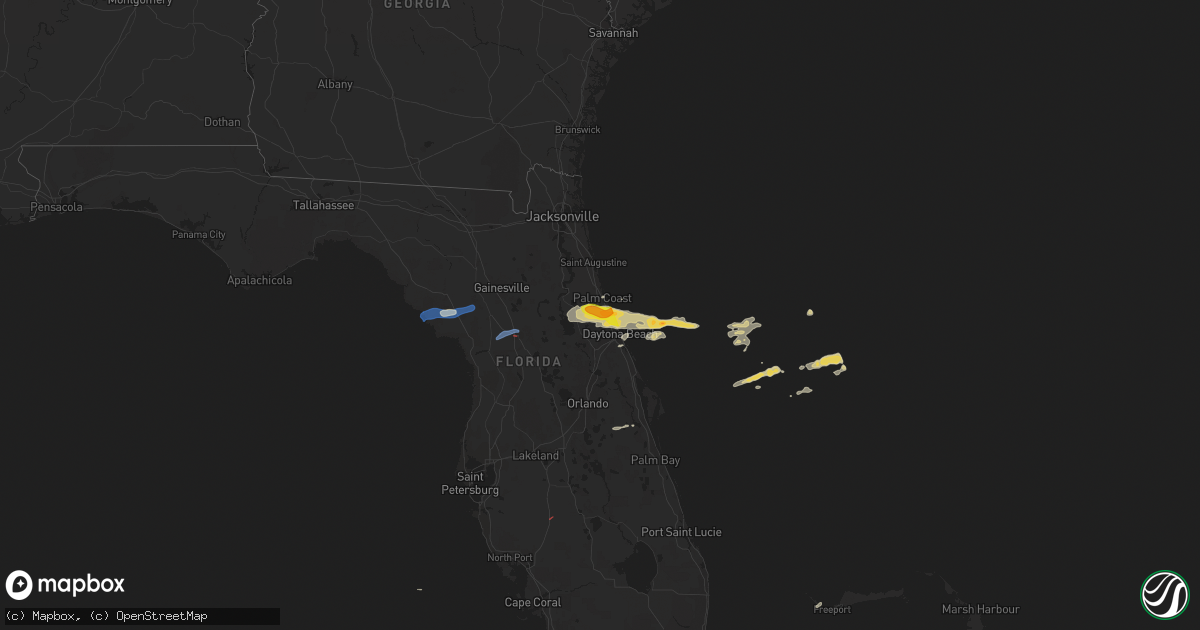
Hail Map on April 18, 2021
Get this storm
April 18 map
$229
one time, instant access
Download today. No call, no setup
Keep the $229
Bought the map and want the full workflow? Apply the entire $229 to a subscription within 7 days. None of it is wasted.
Every map, not just this one
This buys you this map. Subscription and you get every map we run, in the markets you choose from a few cities to whole states to nationwide. Plus real-time alerts the moment a storm fires.
Contact data
Name, contact info, occupancy, even credit band for addresses in the footprint. You go from where it hit to who to call.
Become the source they trust
Unlimited branding weather history reports on demand. You already have the documented answer ready for the property owner, and you are the one who showed up with it.
Property data and RoofTrace estimates
Pull up any address you have got, its value and the exact code rules for that jurisdiction, straight from One Click Code. Then RoofTrace estimates the squares, pitch, and roof value, priced the way you price.
States Impacted by Hail Map on April 18, 2021
Storm reports
Florida
| Date | Description |
|---|---|
| 04/18/20216:23 PM CDT | Emergency management reported a large warehouse damaged along state road 40 east of i-75. Power lines are down and a large live oak tree in an open field was blown down |
| 04/18/202110:07 AM CDT | Broadcast media relayed photos of up to ping pong size hail shared through social media. |
| 04/18/20219:45 AM CDT | Emergency mangager relayed multiple reports from seminole woods section of palm coast south of sr 100 of up to quarter to half dollar size hail posted in images and vid |
| 04/18/20219:43 AM CDT | Quarter size hail was observed along seminole woods section in palm coast. |
| 04/18/20219:41 AM CDT | Trained spotter reported 0.5 inch to 1 inch hail along the volusia/flagler county line... But on the volusia side. |
| 04/18/20219:41 AM CDT | Broadcast media relayed photos of up to ping pong size hail shared through social media near john anderson hwy and walter broadman rd |
| 04/18/20219:35 AM CDT | Flagler county fire rescue reported mutliple trees down along state road 11 for a stretch of 4 miles... From 1 mile south of bunnell to 5 miles south of bunnell. |
| 04/18/20218:19 AM CDT | Reports of tree and power lines down off court st in bronson... Fl. |
| 04/18/20215:25 AM CDT | At 1025 AM EDT, a severe thunderstorm was located near Bunnell, moving east at 45 mph. HAZARD...60 mph wind gusts and penny size hail. SOURCE...Radar indicated. IMPACT...Expect damage to roofs, siding, and trees. Locations impacted include... Palm Coast, Flagler Beach, Bunnell, Beverly Beach and Espanola. |
| 04/18/20213:51 AM CDT | At 851 AM EDT, a severe thunderstorm was located near Bronson, moving east at 45 mph. HAZARD...60 mph wind gusts and penny size hail. SOURCE...Radar indicated. IMPACT...Expect damage to roofs, siding, and trees. Locations impacted include... Williston, Chiefland, Bronson, East Bronson and Otter Creek. |